
Yancey County is a county located in the U.S. state of North Carolina. As of the 2010 census, the population was 17,818. Its county seat is Burnsville.
Scouting in South Carolina has a long history, from the 1910s to the present day, serving thousands of youth in programs that suit the environment in which they live.

Burnsville is a town in, and the county seat of, Yancey County, North Carolina, United States. The population was 1,693 at the 2010 census.

The Tennessee River is the largest tributary of the Ohio River. It is approximately 652 miles (1,049 km) long and is located in the southeastern United States in the Tennessee Valley. The river was once popularly known as the Cherokee River, among other names, as the Cherokee people had their homelands along its banks, especially in what are now East Tennessee and northern Alabama. In addition, its tributary the Little Tennessee River, flows into it from Western North Carolina and northeastern Georgia, where it also was bordered by numerous Cherokee towns. Its current name is derived from the Cherokee town, Tanasi, which was located on the Tennessee side of the Appalachian Mountains.

U.S. Route 19 (US 19) is a north–south U.S. Highway in the Eastern United States. Despite encroaching Interstate Highways, the route has remained a long-haul route, connecting the Gulf of Mexico with Lake Erie.

The Nolichucky River is a 115-mile (185 km) river that flows through Western North Carolina and East Tennessee, in the southeastern United States. Traversing the Pisgah National Forest and the Cherokee National Forest in the Blue Ridge Mountains, the river's watershed is home to some of the highest mountains in the Appalachians, including Mount Mitchell in North Carolina, the highest point in the eastern United States. The river is a tributary of the French Broad River, and is impounded by Nolichucky Dam near Greeneville, Tennessee.

In the United States, A National Heritage Area (NHA) is a site designated by Act of Congress, intended to encourage historic preservation of the area and an appreciation of the history and heritage of the site. There are currently 55 NHAs, some of which use variations of the title, such as National Heritage Corridor.
The Natchez District was one of two areas established in the Kingdom of Great Britain's West Florida colony during the 1770s – the other being the Tombigbee District. The first Anglo settlers in the district came primarily from other parts of British America. The district was recognized to be the area east of the Mississippi River from Bayou Sara in the south and Bayou Pierre in the north.

Pisgah National Forest is a National Forest in the Appalachian Mountains of western North Carolina. It is administered by the United States Forest Service, part of the United States Department of Agriculture. The Pisgah National Forest is completely contained within the state of North Carolina. The forest is managed together with the other three North Carolina National Forests from common headquarters in Asheville, North Carolina. There are local ranger district offices located in Pisgah Forest, Mars Hill, and Nebo.

The Black Mountains are a mountain range in western North Carolina, in the southeastern United States. They are part of the Blue Ridge Province of the Southern Appalachian Mountains. The Black Mountains are the highest mountains in the Eastern United States. The range takes its name from the dark appearance of the red spruce and Fraser fir trees that form a spruce-fir forest on the upper slopes which contrasts with the brown or lighter green appearance of the deciduous trees at lower elevations. The Eastern Continental Divide, which runs along the eastern Blue Ridge crest, intersects the southern tip of the Black Mountain range.
U.S. Route 19E (US 19E) is a divided highway of US 19 in the U.S. states of North Carolina and Tennessee. The U.S. Highway, which is complemented by US 19W to the west, travels 75.9 miles (122.1 km) from US 19 and US 19W at Cane River, North Carolina, north to US 11E, US 19, and US 19W in Bluff City, Tennessee. US 19E connects Asheville, North Carolina, and Bristol, Tennessee, with Burnsville, Spruce Pine, and Elk Park in North Carolina and Roan Mountain and Elizabethton in Tennessee. US 19E also has an unsigned concurrency with Tennessee State Route 37 (SR 37) for its entire course in Tennessee.
U.S. Route 19W traverses approximately 63 miles (101 km) from Cane River, North Carolina to Bluff City, Tennessee.

The Sumter National Forest is one of two forests in South Carolina that are managed together by the United States Forest Service, the other being the Francis Marion National Forest. The Sumter National Forest consists of 370,442 acres (1,499.13 km2) which are divided into 3 distinct sections in western and central South Carolina. The Enoree Ranger District is the largest, comprising roughly 170,000 acres in Chester, Fairfield, Laurens, Newberry, and Union counties. Next is the Long Cane Ranger District, comprising about 120,000 acres in Abbeville, Edgefield, Greenwood, McCormick, and Saluda counties. The smallest district is the Andrew Pickens Ranger District comprising over 85,000 acres which lies entirely in Oconee county and is part of the Appalachian Mountains. Forest headquarters of both South Carolina forests are located together in the state's capital city of Columbia.
Cane Creek Mountains is a small mountain range that lies south of Burlington, North Carolina. The range covers an area including Alamance County, Guilford County, Randolph County, and Chatham County in North Carolina.
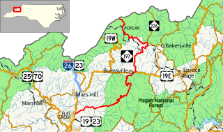
North Carolina Highway 197 is a north/south state highway in Western North Carolina. The route is approximately 58 miles (93 km) in length and with its continuation into Tennessee as SR 395 connects Erwin, Tennessee to Flat Creek, North Carolina. Portions of this highway lie within the Pisgah National Forest and is one of the few highways in the state with an unpaved portion.
U.S. Route 19 (US 19) traverses 145 miles (233 km) across Western North Carolina; from the Georgia state line, at the community of Bellview, to Cane River, where US 19 splits into US 19E and US 19W, which take separate routes into Tennessee.
Cane or caning may refer to:
The Cane Creek Friends Meeting, founded in 1751, is considered the first established Quaker community in the Piedmont region of North Carolina. The site was occupied by British troops during the American Revolutionary War.

Arundinaria gigantea is a species of bamboo known as giant cane and river cane. It is endemic to the south-central and southeastern United States as far west as Oklahoma and Texas and as far north as New York. This species is divided into two subspecies. The subspecies tecta is sometimes treated as a species in its own right, Arundinaria tecta, and is the taxon generally called switch cane. It is very similar to the nominate subspecies (gigantea), but is often smaller and tends to grow in wetter habitats.
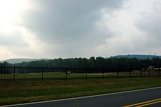
The Cane River is a 38.3-mile (61.6 km) river in Yancey County, North Carolina. It originates from the confluence of Beech Nursery Creek, off the western slope of Mount Mitchell, and Blue Sea Creek, off the northeastern slope of Blackstock Knob, in the Black Mountains. A tributary in the French Broad River basin, it flows northward to join the North Toe River, forming the Nolichucky River.

