Orange County, often known by its initials O.C., is a county located in the Los Angeles metropolitan area in Southern California, United States. As of the 2020 census, the population was 3,186,989, making it the third-most-populous county in California, the sixth-most-populous in the United States, and more populous than 19 American states and Washington, D.C. Although largely suburban, it is the second-most-densely-populated county in the state behind San Francisco County. The county's three most-populous cities are Anaheim, Santa Ana, and Irvine, each of which has a population exceeding 300,000. Santa Ana is also the county seat. Six cities in Orange County are on the Pacific coast: Seal Beach, Huntington Beach, Newport Beach, Laguna Beach, Dana Point, and San Clemente.

State Route 1 (SR 1) is a major north–south state highway that runs along most of the Pacific coastline of the U.S. state of California. At 656 miles (1,056 km), it is the longest state route in California, and the second-longest in the US after Montana Highway 200. SR 1 has several portions designated as either Pacific Coast Highway (PCH), Cabrillo Highway, Shoreline Highway, or Coast Highway. Its southern terminus is at Interstate 5 (I-5) near Dana Point in Orange County and its northern terminus is at U.S. Route 101 (US 101) near Leggett in Mendocino County. SR 1 also at times runs concurrently with US 101, most notably through a 54-mile (87 km) stretch in Ventura and Santa Barbara counties, and across the Golden Gate Bridge.
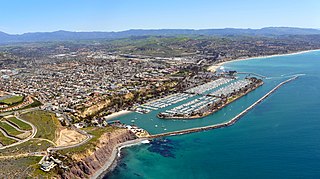
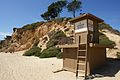
Dana Point is a city located in southern Orange County, California, United States. The population was 33,107 at the 2020 census. It has one of the few harbors along the Orange County coast, and with ready access via State Route 1, it is a popular local destination for surfing.

Laguna Niguel is a city in Orange County, California, United States. The name Laguna Niguel is derived from the words "Laguna" and "Niguili". As of the 2020 census, the population was 64,355. Laguna Niguel is located in the San Joaquin Hills in the southeastern corner of Orange County, close to the Pacific Ocean, and borders the cities of Aliso Viejo, Dana Point, Laguna Beach, Laguna Hills, Mission Viejo, and San Juan Capistrano.

San Clemente is a city in Orange County, California, United States. Located in the Orange Coast region of the South Coast of California, San Clemente's population was 64,293 in at the 2020 census. Situated roughly midway between Los Angeles and San Diego, San Clemente is a popular tourist destination in Southern California, known for its beaches, Spanish Colonial Revival architecture, and hospitality industry. San Clemente's city slogan is "Spanish Village by the Sea".
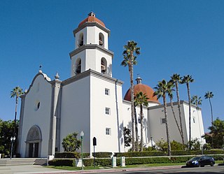
San Juan Capistrano is a city in southern Orange County, California, United States. The population was 35,253 at the 2020 Census.

Santa Monica Bay is a bight of the Pacific Ocean in Southern California, United States. Its boundaries are slightly ambiguous, but it is generally considered to be the part of the Pacific within an imaginary line drawn between Point Dume, in Malibu, and the Palos Verdes Peninsula. Its eastern shore forms the western boundary of the Los Angeles Westside and South Bay regions. Although it was fed by the Los Angeles River until the river's catastrophic change of course in 1825, the only stream of any size now flowing into it is Ballona Creek. Smaller waterways draining into the bay include Malibu Creek, Topanga Creek, and Santa Monica Creek.
Capistrano Unified School District (CUSD) is the largest school district in Orange County, California, United States. It is the 9th largest district in the state and the 78th largest in the country. The district currently has 54,036 students and administers 33 elementary schools, two K-8 schools, ten middle schools, six comprehensive high schools, five charter schools, and multiple alternative education programs.

Doheny State Beach is known as the first state beach in the California state park system. Located on the Pacific Ocean in the city of Dana Point, the beach is adjacent to several surf spots and scenic beaches including Salt Creek Beach, Baby Beach, and Capistrano Beach. Along with its neighbors, Doheny beach is a popular surf spot located at the mouth of San Juan Creek, which flows from the Santa Ana Mountains southwest to the beach, where it forms a fresh-water lagoon.

The San Joaquin Hills are a low mountain range of the Peninsular Ranges System, located in coastal Orange County, California.

Rancho San Pedro was one of the first California land grants and the first to win a patent from the United States. The Spanish Crown granted the 75,000 acres (300 km2) of land to soldier Juan José Domínguez in 1784, with his descendants validating their legal claim with the Mexican government at 48,000 acres (190 km2) in 1828, and later maintaining their legal claim through a United States patent validating 43,119 acres (174.50 km2) in 1858. The original Spanish land grant included what today consists of the Pacific coast cities of Los Angeles harbor, San Pedro, the Palos Verdes peninsula, Torrance, Redondo Beach, Hermosa Beach, and Manhattan Beach, and east to the Los Angeles River, including the cities of Lomita, Gardena, Harbor City, Wilmington, Carson, Compton, and western portions of Long Beach and Paramount.

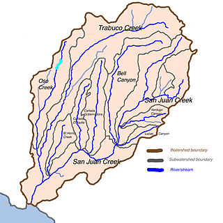
San Juan Creek, also called the San Juan River, is a 29-mile (47 km) long stream in Orange and Riverside Counties, draining a watershed of 133.9 square miles (347 km2). Its mainstem begins in the southern Santa Ana Mountains in the Cleveland National Forest. It winds west and south through San Juan Canyon, and is joined by Arroyo Trabuco as it passes through San Juan Capistrano. It flows into the Pacific Ocean at Doheny State Beach. State Route 74, the Ortega Highway, crosses the Santa Ana Mountains via San Juan Canyon.

Aliso Creek is a 19.8-mile (31.9 km)-long, mostly urban stream in south Orange County, California. Originating in the Cleveland National Forest in the Santa Ana Mountains, it flows generally southwest and empties into the Pacific Ocean at Laguna Beach. The creek's watershed drains 34.9 square miles (90 km2), and it is joined by seven main tributaries. As of 2018, the watershed had a population of 144,000 divided among seven incorporated cities.

Sulphur Creek is an approximately 4.5-mile (7.2 km) tributary of Aliso Creek in Orange County, California. The creek drains about 6 square miles (16 km2) in the suburban cities of Laguna Niguel and Laguna Hills. Although most of its watershed has been utilized for master planned residential development, the creek retains a natural channel with riparian and wetland habitat in parts of Laguna Niguel Regional Park and Aliso and Wood Canyons Regional Park. Urban runoff has changed the once seasonal creek into a perennial stream.

Bell Canyon is a major drainage of the Santa Ana Mountains in Orange County, California in the United States. Bell Creek flows about 14.4 miles (23.2 km) in a southerly direction to its confluence with San Juan Creek. The Bell Canyon drainage is located to the east and parallel to Cañada Gobernadora, and to the south of Trabuco Creek. After Trabuco Creek, it is the second largest tributary of San Juan Creek in terms of length and its watershed area of 26 square miles (67 km2).
Trampas Canyon is a short tributary of San Juan Creek in southern Orange County the U.S. state of California. It rises in forks on steep slopes of the southern Santa Ana Mountains, and flows north to where it is dammed by Trampas Canyon Dam. Trampas Canyon 1795-006 Dam (33.498359°N 117.587548°W) forms a small lake that branches into four forks running east–west. Exiting the dam, the creek flows north and turns slightly to the west, where it joins San Juan Creek on the left bank, near the confluence of Cañada Gobernadora. Trampas Canyon Creek is ephemeral and only flows during storm events or while Trampas Canyon Dam is releasing, and is not a primary tributary of San Juan Creek.
Rancho Niguel was a 13,316-acre (53.89 km2) Mexican land grant in the San Joaquin Hills, within present-day Orange County, California.
Rancho Boca de la Playa was a 6,607-acre (26.74 km2) Mexican land grant in present-day Orange County, California given in 1846 by Governor Pío Pico to Emigdio Véjar. The name refers to the wetlands estuary at the 'mouth of the beach,' or 'boca de la playa' in Spanish. This is the most southerly grant in Orange County, and extended along the Pacific coast from San Juan Creek in the south of present-day San Juan Capistrano south to San Clemente.
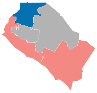
The 2018 Orange County Board of Supervisors elections was on June 5, 2018 as part of the primary election on June 5, 2018. Three of the five seats of the Orange County, California Board of Supervisors were up for election.