Related Research Articles
Washington Union Station, known locally as Union Station, is a major train station, transportation hub, and leisure destination in Washington, D.C. Designed by Daniel Burnham and opened in 1907, it is Amtrak's headquarters, the railroad's second-busiest station, and North America's 10th-busiest railroad station. The station is the southern terminus of the Northeast Corridor, an electrified rail line extending north through major cities including Baltimore, Philadelphia, New York City, and Boston, and the busiest passenger rail line in the nation. In 2015, it served just under five million passengers.

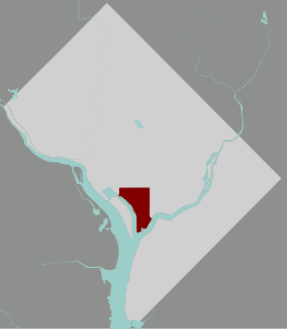
Southwest is the southwestern quadrant of Washington, D.C., the capital of the United States, and is located south of the National Mall and west of South Capitol Street. It is the smallest quadrant of the city, and contains a small number of named neighborhoods and districts, including Bellevue, Southwest Federal Center, the Southwest Waterfront, Buzzard Point, and the military installation known as Joint Base Anacostia–Bolling.

Downtown Crossing station is an underground Massachusetts Bay Transportation Authority (MBTA) rapid transit station located in the Downtown Crossing retail district in the downtown core of Boston, Massachusetts. It is served by the Orange Line and Red Line, and is one of four "hub stations" on the MBTA subway system. Downtown Crossing is also a major bus transfer location serving 13 MBTA bus routes, including one Silver Line route. It is the second busiest subway station in the MBTA network, with an average of 24,074 entries per weekday in FY2019.

L'Enfant Plaza is a complex of four commercial buildings grouped around a large plaza in the Southwest section of Washington, D.C., United States. Immediately below the plaza and the buildings is La Promenade shopping mall.
Pentagon City is an unincorporated neighborhood located in the southeast portion of Arlington County, Virginia, near the Pentagon and Arlington National Cemetery.

Interstate 395 (I-395) in Washington, D.C., and Virginia is a 13.79-mile-long (22.19 km) spur route of I-95 that begins at an interchange with I-95 in Springfield and ends at an interchange with US Route 50 (US 50) in Northwest Washington, D.C. It passes underneath the National Mall near the US Capitol and ends at a junction with US 50 at New York Avenue, roughly one mile (1.6 km) north of the 3rd Street Tunnel. Despite its proximity to I-395 in Maryland, the route is unrelated and unconnected.

Constitution Avenue is a major east–west street in the northwest and northeast quadrants of the city of Washington, D.C., in the United States. It was originally known as B Street, and its western section was greatly lengthened and widened between 1925 and 1933. It received its current name on February 26, 1931, though it was almost named Jefferson Avenue in honor of Thomas Jefferson.

New York Avenue is a diagonal avenue radiating northeast from the White House in Washington, D.C. to the border with Maryland. It is a major east–west route in the city's Northwest and Northeast quadrants and connects downtown with points east and north of the city via Cheverly, Maryland, the John Hanson Highway, the Baltimore–Washington Parkway, and eventually, Interstate 95.

Massachusetts Avenue is a major diagonal transverse road in Washington, D.C., and the Massachusetts Avenue Historic District is a historic district that includes part of it.

Downtown Portland is the central business district of Portland, Oregon, United States. It is on the west bank of the Willamette River in the northeastern corner of the southwest section of the city and where most of the city's high-rise buildings are found.

The name "M Street" refers to two major roads in the United States capital of Washington, D.C. Because of the Cartesian coordinate system used to name streets in Washington, the name "M Street" can be used to refer to any east-west street located twelve blocks north or south of the dome of the United States Capitol. Thus, in all four quadrants of the city there are streets called "M Street", which are disambiguated by quadrant designations, namely, M Street NW, NE, SW, and SE.
The Southwest Waterfront is a neighborhood in Southwest Washington, D.C. The Southwest quadrant is the smallest of Washington's four quadrants, and the Southwest Waterfront is one of only two residential neighborhoods in the quadrant; the other is Bellevue, which, being east of the Anacostia River, is frequently, if mistakenly, regarded as being in Southeast

Navy Yard, also known as Near Southeast, is a neighborhood on the Anacostia River in Southeast Washington, D.C. Navy Yard is bounded by Interstate 695 to the north and east, South Capitol Street to the west, and the Anacostia River to the south. Approximately half of its area is occupied by the Washington Navy Yard, which gives the neighborhood its name. The neighborhood is located in D.C.'s Ward 8, currently represented by Trayon White. It is served by the Navy Yard – Ballpark Metro station on the Green Line.

Downtown is the central business district of Washington, D.C., located in Northwest D.C. It is the fourth largest central business district in the United States. The "Traditional Downtown" has been defined as an area roughly between Union Station in the east and 16th Street NW in the west, and between the National Mall on the south and Massachusetts Avenue on the north, including Penn Quarter. However, nowadays, Downtown D.C. usually refers to a larger area, as the DC Office of Planning states:
…most residents, workers, and visitors think of Downtown in a broader sense — including areas as far north as Dupont Circle, as far west as Foggy Bottom, and as far east as Capitol Hill. Only about half of the central city workforce is located within the city’s traditional Downtown.

Capitol View is a historic in-town southwest Atlanta neighborhood 2.5 miles from downtown Atlanta, Georgia that was named for its view of the Georgia State Capitol building. Its boundaries include Metropolitan Parkway to the east, Lee Street to the west, and the Beltline to the north. On the south, the border follows Arden Street, Deckner Avenue, and Perkerson Park.

The District Department of Transportation is an agency of the government of the District of Columbia, in the United States, which manages and maintains publicly owned transportation infrastructure in the District of Columbia. DDOT is the lead agency with authority over the planning, design, construction, and maintenance of alleys, bridges, sidewalks, streets, street lights, and traffic signals in the District of Columbia.

CityCenterDC, sometimes colloquially called CityCenter, is a mixed-use development consisting of two condominium buildings, two rental apartment buildings, two office buildings, a luxury hotel, and public park in downtown Washington, D.C. It encompasses 2,000,000 square feet (190,000 m2) and covers more than five city blocks. The $950 million development began construction on April 4, 2011, on the site of the former Washington Convention Center—a 10.2-acre (4.1 ha) site bounded by New York Avenue NW, 9th Street NW, H Street NW, and 11th Street NW. Most of the development was completed and open for business by summer 2015. The luxury hotel Conrad Washington, DC, opened in February 2019.
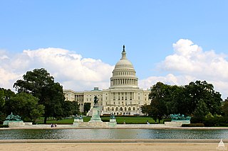
Union Square is an 11-acre public plaza at the foot of Capitol Hill in Washington, D.C., United States. It encompasses the Ulysses S. Grant Memorial (1924) and the 6-acre Capitol Reflecting Pool (1971) and is just west of the United States Capitol building. Views differ as to whether the Square is just east of the National Mall or is itself the eastern end.

Mount Vernon Triangle is a neighborhood and community improvement district in the northwest quadrant of Washington, D.C. The neighborhood is located adjacent to Mount Vernon Square. Originally a working-class neighborhood established in the 19th century, present-day Mount Vernon Triangle experienced a decline in the mid-20th century as it transitioned from residential to commercial and industrial use.
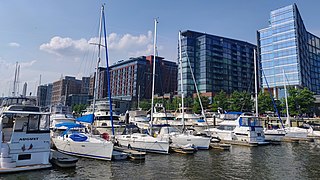
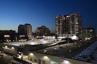
The Wharf, formally The District Wharf, is a multi-billion dollar mixed-use development on the Southwest Waterfront in Washington, D.C. It contains the city's historic Maine Avenue Fish Market, hotels, residential buildings, restaurants, shops, parks, piers, docks and marinas, and live music venues. The first phase of The Wharf opened in October 2017 and the second and final phase was completed in October 2022. The neighborhood encompasses 24 acres of land, 50 acres of water, and contain 3.2 million square feet (300,000 m2) of retail, residential, and entertainment space along 1 mile (1.6 km) of the Potomac River shoreline from the Francis Case Memorial Bridge to Fort McNair.
References
- 1 2 3 Goldchain, Michelle. "Capitol Crossing: What to Expect from One of D.C.'s Largest Revitalization Projects", "DC Government", 6 April 2016.
- ↑ Banister, Jon. "$1.3B CAPITOL CROSSING PROJECT BEGINS TO GO VERTICAL", "Bisnow", 15 June 2016.
- ↑ Capitol Crossing Washington D.C.
- 1 2 Sherwood, Tom. "$1.3 Billion Capitol Crossing Project Will Be One of D.C.'s Biggest Projects Ever -- But Drivers, Beware", "NBC", 13 June 2015.
- ↑ Sadon, Rachel. "Five Things To Know About The Capitol Crossing Project, DCist" Archived 2016-05-18 at the Wayback Machine , "Gothamist", 12 May 2015.
- ↑ Capitol Crossing: Sustainability Features
- ↑ Fox, Kohn. "Capitol Crossing DC", "Architect", 12 May 2015.
- ↑ Lazo, Luz. "Major work for Capitol Crossing project is set to begin on I-395", "The Washington Post", 23 June 2015.