Carnegie, Oklahoma

Last updated

Carnegie, Oklahoma
The Liberty Theatre.jpg
The Carnegie Liberty Theatre in Carnegie
OKMap-doton-Carnegie.PNG
Location of Carnegie, Oklahoma
Coordinates: 35°06′10″N98°35′59″W / 35.10278°N 98.59972°W / 35.10278; -98.59972
Country United States
State Oklahoma
County Caddo
Town founded1903
Government
  Town Board of TrusteesMayor
Wesley Taylor
Vice-Mayor
Johnnie Goergen
Members
Delores Bartosovsky
Angela Dodson
  Other city officialsTown Clerk
Debbie Clinton
Town Treasurer
Judy Patterson
Town Judge
Jim Hines
Area
[1]
  Total1.33 sq mi (3.45 km2)
  Land1.33 sq mi (3.45 km2)
  Water0.00 sq mi (0.00 km2)
Elevation
[2]
1,339 ft (408 m)
Population
 (2020)
  Total1,430
  Density1,072.77/sq mi (414.28/km2)
Time zone UTC-6 (Central (CST))
  Summer (DST) UTC-5 (CDT)
ZIP code
73015
Area code 580
FIPS code 40-12050 [3]
GNIS feature ID2413171 [2]
Website Town website

Carnegie is a town in Caddo County, Oklahoma, United States. The population was 1,430 as of the 2020 United States census. [4]

Contents

History and culture

Carnegie was named after the famous Scottish American industrialist and philanthropist, Andrew Carnegie. The initial name of the town was Latham. The town was originally platted as North and South Latham, with North Latham being north of the Washita River, and South Latham being south of it. North Latham was intended to be the commercial hub, with the Chicago, Rock Island and Pacific Railway expected to go along the north side of the river. [5] However, the tracks ended up running along the south bank of the Washita, so South Latham became the commercial hub and North Latham withered and/or was never developed. [5]

Leaders of the town decided shortly after incorporation in 1903 to rename the town Carnegie in the hopes the industrialist would build a library there. [lower-alpha 1] Although the town acquired a library, Andrew Carnegie did not provide it. Of note, there is unofficially a "Carnegie Hall", known more properly as the Carnegie Memorial Auditorium, where community events are held. While currently on hiatus, for several years there was an annual "Stars of Carnegie Hall" talent show showcasing individuals across the region and state in a local talent show, in which both local and regional talents were represented.

Carnegie High School has won three state titles in boys basketball (1988, 1992, 1996), as well as three titles in girls cross country (2002, 2003, 2004). Carnegie High also has three won state titles in boys cross country (1999, 2000, 2020). The Kiowa Tribe of Oklahoma headquarters are located in Carnegie.

Geography

According to the United States Census Bureau, the town has a total area of 1.37 square miles (3.55 km2), all land. [6]

The town is on the south bank of the Washita River, 27 miles (43 km) west of Anadarko, at the intersection of state highways 9 and 58. [5]

Climate

Climate data for Carnegie, Oklahoma
MonthJanFebMarAprMayJunJulAugSepOctNovDecYear
Mean daily maximum °F (°C)49.7
(9.8)
54.9
(12.7)
64.8
(18.2)
74.8
(23.8)
82.3
(27.9)
90.5
(32.5)
96.2
(35.7)
94.9
(34.9)
86.4
(30.2)
76.3
(24.6)
62.4
(16.9)
52.1
(11.2)
73.8
(23.2)
Mean daily minimum °F (°C)24.0
(−4.4)
29.1
(−1.6)
38.0
(3.3)
48.3
(9.1)
57.3
(14.1)
66.1
(18.9)
70.5
(21.4)
68.8
(20.4)
61.4
(16.3)
49.6
(9.8)
37.8
(3.2)
27.7
(−2.4)
48.2
(9.0)
Average precipitation inches (mm)0.9
(23)
1.4
(36)
2.0
(51)
2.4
(61)
5.1
(130)
4.0
(100)
2.0
(51)
2.3
(58)
4.0
(100)
2.4
(61)
1.6
(41)
1.1
(28)
29.2
(740)
Source 1: weather.com
Source 2: Weatherbase.com [7]

Demographics

Historical population
CensusPop.Note
1910 835
1920 1,15037.7%
1930 2,06379.4%
1940 1,740−15.7%
1950 1,719−1.2%
1960 1,500−12.7%
1970 1,72314.9%
1980 2,01617.0%
1990 1,593−21.0%
2000 1,6372.8%
2010 1,7235.3%
2020 1,430−17.0%
U.S. Decennial Census [8]

As of the census [3] of 2000, there were 1,637 people, 636 households, and 429 families residing in the town. The population density was 1,468.0 inhabitants per square mile (566.8/km2). There were 774 housing units at an average density of 694.1 per square mile (268.0/km2). The racial makeup of the town was 64.63% White, 1.22% African American, 23.58% Native American, 8.80% from other races, and 1.77% from two or more races. Hispanic or Latino of any race were 12.28% of the population.

There were 636 households, out of which 31.4% had children under the age of 18 living with them, 48.3% were married couples living together, 15.3% had a female householder with no husband present, and 32.4% were non-families. 30.0% of all households were made up of individuals, and 19.5% had someone living alone who was 65 years of age or older. The average household size was 2.49 and the average family size was 3.10.

In the town, the population was spread out, with 27.4% under the age of 18, 8.0% from 18 to 24, 23.3% from 25 to 44, 20.3% from 45 to 64, and 21.0% who were 65 years of age or older. The median age was 38 years. For every 100 females, there were 88.8 males. For every 100 females age 18 and over, there were 83.8 males.

The median income for a household in the town was $20,987, and the median income for a family was $24,737. Males had a median income of $21,917 versus $14,868 for females. The per capita income for the town was $12,432. About 24.9% of families and 30.5% of the population were below the poverty line, including 42.2% of those under age 18 and 18.6% of those age 65 or over.

Government

Carnegie is governed by a five-member Town Board of Trustees, as authorized by the Oklahoma Constitution. Members are elected at large from within the town limits for four-year terms. Other public officials include a town clerk and a town treasurer. [9]

The Town of Carnegie operates and maintains a solid waste/sanitation service, and also a water and sewer service, operated through the Carnegie Public Works Authority. [10]

The town has a 19-member volunteer fire department. [11]

The Carnegie Tri-County Municipal Hospital Authority owns a critical-access hospital and clinic facility within the town that provides residents of the area with primary care, radiology, physical therapy, and medical laboratory services. Limited surgical services are also provided. The Carnegie Tri-County Municipal Hospital has three doctors and one nurse practitioner on staff. The hospital is managed and operated by Carnegie Tri-County Hospital Management, Inc. [12]

The Carnegie Library Board, appointed by the Town Board of Trustees, operates a library facility for area residents, providing internet access and a large collection of books, magazines, and audio books.

Economy

Agriculture has been the basis of Carnegie's economy throughout its history. The main production has been cotton, wheat, broomcorn, cattle, hogs and poultry. Oil production replaced agriculture briefly during the 1970s, but declined in economic importance after 1980. [5]

Community

Carnegie is home to Liberty Theater, the oldest continually operated movie theater in Oklahoma.

Carnegie is host to many community events, including the Carnegie Tri-County Free Fair, the Carnegie Round-Up Club Rodeo, the World Championship Domino Tournament, as well as various other community events throughout the year.

Carnegie also is the home of the Kiowa Tribe of Oklahoma, which has tribal offices located on the west edge of town.

Transportation

The Town of Carnegie operates and maintains the Carnegie Municipal Airport (Location ID: 86F). There is one asphalt runway, 35/17, 3300 ft long. There are no refueling services available at the airport.

Utilities

Notable people

Notes

  1. According to the Encyclopedia of Oklahoma History and Culture, the town was renamed in 1901 because there was another community named Latham in Oklahoma Territory. This source also says that Carnegie incorporated in 1906. [5]

Related Research Articles

<span class="mw-page-title-main">Washita County, Oklahoma</span> County in Oklahoma, United States

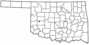
Washita County is a county located in the U.S. state of Oklahoma. As of the 2020 census, the population was 10,924. Its county seat is New Cordell. The county seat was formerly located in Cloud Chief. The county was created in 1891.

<span class="mw-page-title-main">Roger Mills County, Oklahoma</span> County in Oklahoma, United States

Roger Mills County is a county located in the western part of the U.S. state of Oklahoma. As of the 2020 census, the population was 3,442, making it the fourth-least populous county in Oklahoma. Its county seat is Cheyenne. The county was created in 1891.

<span class="mw-page-title-main">Kiowa County, Oklahoma</span> County in Oklahoma, United States

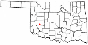
Kiowa County is a county located in the southwestern part of the U.S. state of Oklahoma. As of the 2020 census, the population was 8,509. Its county seat is Hobart. The county was created in 1901 as part of Oklahoma Territory. It was named for the Kiowa people.

<span class="mw-page-title-main">Carter County, Oklahoma</span> County in Oklahoma, United States

Carter County is a county in the U.S. state of Oklahoma. As of the 2020 census, the population was 48,003. Its county seat is Ardmore. The county was named for Captain Ben W. Carter, a Cherokee who lived among the Chickasaw.

<span class="mw-page-title-main">Caddo County, Oklahoma</span> County in Oklahoma, United States

Caddo County is a county located in the U.S. state of Oklahoma. As of the 2020 census, the population was 26,945. Its county seat is Anadarko. Created in 1901 as part of Oklahoma Territory, the county is named for the Caddo tribe who were settled here on a reservation in the 1870s. Caddo County is immediately west of the seven-county Greater Oklahoma City metro area, and although is not officially in the metro area, it has many economic ties in this region.

<span class="mw-page-title-main">Anadarko, Oklahoma</span> City in Oklahoma, United States

Anadarko is a city and county seat of Caddo County, Oklahoma, United States. The city is fifty miles (80.5 km) southwest of Oklahoma City. The population was 5,745 at the 2020 census.

<span class="mw-page-title-main">Apache, Oklahoma</span> Town in Oklahoma, United States

Apache is a town in Caddo County, Oklahoma, United States. The population was 1,444 at the 2010 census.

<span class="mw-page-title-main">Binger, Oklahoma</span> Town in Oklahoma, United States

Binger is a town in Caddo County, Oklahoma, United States. The population was 672 at the 2010 census. It is the headquarters of the Caddo Nation of Oklahoma, who were settled in the area during the 1870s.

<span class="mw-page-title-main">Fort Cobb, Oklahoma</span> Town in Oklahoma, United States

Fort Cobb is a town in Caddo County, Oklahoma, United States. The population was 518 at the 2020 census.

<span class="mw-page-title-main">Sterling, Oklahoma</span> Town in Oklahoma, United States

Sterling is a town in Comanche County, Oklahoma, United States. The population was 793 at the 2010 census. It is part of the Lawton Metropolitan Statistical Area.

<span class="mw-page-title-main">Lindsay, Oklahoma</span> City in Oklahoma, United States

Lindsay is a city in Garvin County, Oklahoma, United States. The population was 2,840 at the 2010 census. It once promoted itself as "The Broomcorn Capital of the World" but no longer uses that slogan, as broomcorn is no longer raised in the area.

<span class="mw-page-title-main">Maysville, Oklahoma</span> Town in Oklahoma, United States

Maysville is a town in Garvin and McClain counties, Oklahoma, United States. The population was 1,232 at the 2010 census, down from 1,313 in 2000.

<span class="mw-page-title-main">Verden, Oklahoma</span> Town in Oklahoma, United States

Verden is a town in western Grady County, Oklahoma, United States. It abuts the Caddo County line, and is probably best known as the site of the 1865 Camp Napoleon Council. The population was 580 at the 2020 census, a decline from 530 in 2010.

<span class="mw-page-title-main">Tishomingo, Oklahoma</span> City in Oklahoma

Tishomingo is the largest city in, and the county seat of, Johnston County, Oklahoma, United States. The population was 3,034 at the 2010 census, a decline of 4.1 percent from the figure of 3,162 in 2000. It was the first capital of the Chickasaw Nation, from 1856 until Oklahoma statehood in 1907. The city is home to Murray State College, a community college with an annual enrollment of 3,015 students. Tishomingo is part of the Texoma region.

<span class="mw-page-title-main">Hobart, Oklahoma</span> City in Oklahoma, United States

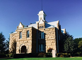
Hobart is a city in, and the county seat of, Kiowa County, Oklahoma, United States. It is west-southwest of Oklahoma City, and northwest of Lawton. It was named for Garret Hobart, the 24th Vice President of the United States. The population was 3,413 at the 2020 Census. It is served by Hobart Regional Airport. It also has two museums: the General Tommy Franks Museum and the Kiowa County Museum.

<span class="mw-page-title-main">Smith Village, Oklahoma</span> Town in Oklahoma, United States

Smith Village is a town in Oklahoma County, Oklahoma, United States, and a part of the Oklahoma City Metropolitan Area. The population was 66 at the 2010 census.

<span class="mw-page-title-main">Foss, Oklahoma</span> Town in Oklahoma, United States

Foss is a town in Washita County, Oklahoma, United States. As of the 2010 census, the town population was 151, an 18.9 percent increase from 127 at the 2000 census.

<span class="mw-page-title-main">New Cordell, Oklahoma</span> City in Oklahoma, United States

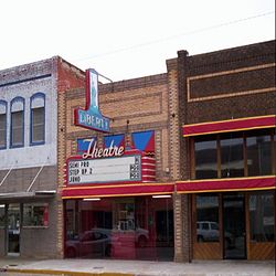
New Cordell is a city in, and county seat of, Washita County, Oklahoma, United States. It lies along U.S. Route 183. The population was 2,915 at the 2010 census. The community was previously established a few miles from the current site, but was moved about 1900. It was named for a U.S. Postal Service employee in Washington D. C., Wayne W. Cordell. The official name is New Cordell, though it is now commonly called Cordell.

<span class="mw-page-title-main">Rocky, Oklahoma</span> Town in Oklahoma, United States

Rocky is a town in Washita County, Oklahoma, United States. The population was 162 at the 2010 United States Census, a 6.9 percent decline from the figure of 174 in 2000. The town lies along U.S. Route 183.

<span class="mw-page-title-main">Lake Kiowa, Texas</span> Census-designated place in Texas, United States

Lake Kiowa is a census-designated place (CDP) in Cooke County, Texas, United States, the majority of which consists of the gated community of the same name.

References

  1. "ArcGIS REST Services Directory". United States Census Bureau. Retrieved September 20, 2022.
  2. 1 2 U.S. Geological Survey Geographic Names Information System: Carnegie, Oklahoma
  3. 1 2 "U.S. Census website". United States Census Bureau . Retrieved January 31, 2008.
  4. "Carnegie (town), Oklahoma". U.S. Census Bureau. Retrieved March 19, 2024.
  5. 1 2 3 4 5 Cynthia Savage, "Carnegie," Encyclopedia of Oklahoma History and Culture. Accessed April 17, 2015.
  6. "Geographic Identifiers: 2010 Demographic Profile Data (G001): Carnegie town, Oklahoma". U.S. Census Bureau, American Factfinder. Archived from the original on February 5, 2015. Retrieved February 5, 2015.
  7. "Historical Weather for Carnegie, Oklahoma, United States".
  8. "Census of Population and Housing". Census.gov. Retrieved June 4, 2015.
  9. "Town of Carnegie website "About"". Archived from the original on August 10, 2014. Retrieved August 6, 2014.
  10. Town of Carnegie website "Water & Sewer Service".
  11. "Town of Carnegie website. "Public Safety"". Archived from the original on August 10, 2014. Retrieved August 6, 2014.
  12. "Town of Carnegie website – Hospital". Archived from the original on August 5, 2014. Retrieved August 6, 2014.