Carol City, Florida

Last updated
Carol City
Neighborhood of Miami Gardens
FLMap-doton-CarolCity.PNG
Location in the state of Florida
Coordinates: 25°56′32″N80°16′12″W / 25.94222°N 80.27000°W / 25.94222; -80.27000
Country Flag of the United States.svg  United States
State Flag of Florida.svg  Florida
County Flag of Miami-Dade County, Florida.png Miami-Dade
City  Miami Gardens, Florida
Area
  Total7.7 sq mi (20.0 km2)
  Land7.6 sq mi (19.7 km2)
  Water0.1 sq mi (0.3 km2)
Population
 (2010)
  Total61,233
  Density8,057.0/sq mi (3,108.0/km2)
Time zone UTC-5 (Eastern (EST))
  Summer (DST) UTC-4 (EDT)
ZIP codes
33055-33056
Area code 305
FIPS code 12-10650 [1]

Carol City is a neighborhood in Miami Gardens, Florida, United States. The population was 61,233 at the 2010 census. It was formerly a census-designated place.

Contents

History

Julius Gaines, the developer, had originally planned to name it Coral City. However, under threat of a lawsuit by Coral Gables, he changed the name, switching the O and A. [2]

In the 1960s, much of Carol City included farmland. [3] As the decades progressed, many people in Miami Gardens blamed the public housing in the area, including the developments around Carol City High School, of importing crime and recreational drugs into the area. In 2007, Mayor Shirley Gibson of Miami Gardens announced she would not allow any more public housing projects to open in Miami Gardens. [4]

On July 27, 1977, six people were killed and a further two were injured during a mass shooting at a house in Carol City. At the time, the shooting was the largest case of mass murder in Miami-Dade County history. [5]

Geography

Carol City is located at 25°56′32″N80°16′12″W / 25.94222°N 80.27000°W / 25.94222; -80.27000 (25.942121, -80.269920). [6] According to the United States Census Bureau, the community has a total area of 20.0 km2 (7.7 mi2). 19.7 km2 (7.6 mi2) of it is land and 0.3 km2 (0.1 mi2) of it (1.42%) is water.

Notable people

Demographics

Historical population
CensusPop.Note
1960 21,749
1970 27,36125.8%
1980 47,34973.1%
1990 53,33112.6%
2000 59,44311.5%
2010 61,2333.0%
U.S. Decennial Census [7]
1990 [8] 2000 [9]

As of the census [1] of 2000, there were 59,443 people, 16,402 households, and 14,089 families residing in the community. The population density was 3,012.0/km2 (7,796.0/mi2). There were 17,049 housing units at an average density of 863.9/km2 (2,236.0/mi2). The racial makeup of the CDP was 52.10% African American, 38.11% White (6.4% were Non-Hispanic White,). [10] 0.55% Asian, 0.19% Native American, 0.04% Pacific Islander, 5.53% from other races, and 3.48% from two or more races. Hispanic or Latino of any race were 42.00% of the population.

There were 16,402 households, out of which 42.7% had children under the age of 18 living with them, 52.4% were married couples living together, 26.5% had a female householder with no husband present, and 14.1% were non-families. 10.8% of all households were made up of individuals, and 2.6% had someone living alone who was 65 years of age or older. The average household size was 3.58 and the average family size was 3.75.

In the area the population was spread out, with 31.0% under the age of 18, 9.7% from 18 to 24, 28.6% from 25 to 44, 22.4% from 45 to 64, and 8.2% who were 65 years of age or older. The median age was 32 years. For every 100 females, there were 92.5 males. For every 100 females age 18 and over, there were 87.1 males.

The median income for a household in the community was $38,652, and the median income for a family was $39,596. Males had a median income of $26,079 versus $22,169 for females. The per capita income for the community was $12,600. About 14.3% of families and 16.5% of the population were below the poverty line, including 21.5% of those under age 18 and 18.2% of those age 65 or over.

As of 2000, before being annexed to Miami Gardens, English as a first language accounted for 53.73% of all residents, Spanish accounted for 43.16%, and French Creole made up 2.15% of the population. [11]

As of 2000, the Carol City section of Miami Gardens had the twenty-seventh highest percentage of Cuban residents in the US, with 18.75% of the populace. [12] It had the nineteenth highest percentage of Jamaican residents in the U.S. at 5.80% (which tied with Lake Park, Florida,) [13] and the thirty-ninth highest percentage of Dominican residents in the U.S. at 3% of its population. [14] It had the fifty-sixth most Haitians in the U.S. at 2.50% (tied with five other areas in the U.S., including Plantation and Taft, Florida) [15] while it had the twentieth highest percentage of Nicaraguans at 2.20% of all residents. [16] The Carol City neighborhood of Miami Gardens is home to the seventieth highest percentage of Colombian residents in the U.S. at 2.15% of the population. [17]

Education

Miami Carol City High School Carolcityhigh.jpg
Miami Carol City High School

Carol City is within the Miami-Dade Public Schools district.

Elementary schools within the former CDP that are now in Miami Gardens include Brentwood, Carol City, Barbara Hawkins, Miami Gardens, Myrtle Grove, and Skyway. Elementary schools within the former CDP that are in unincorporated areas include Lake Stevens, North Glade, and Charles David Wyche, Jr. [18]

Carol City Middle School is located in Miami Gardens and in the former CDP. Lake Stevens Middle School is located in an unincorporated area and in the former CDP. Miami Carol City High School is located within Miami Gardens and in the former Carol City CDP. [18] It opened in fall 1963. [3]

The North Campus of Sandor Weiner School of Opportunity, a charter school, is located in the former CDP and in an unincorporated area. [18] [19]

The Roman Catholic Archdiocese of Miami formerly operated the Saint Monica School in the Carol City CDP. [20] [21]

See also

Related Research Articles

<span class="mw-page-title-main">Lauderdale Lakes, Florida</span> City in Florida

Lauderdale Lakes is a city in Broward County, Florida, United States. It is part of the Miami metropolitan area of South Florida. As of the 2020 United States Census, the city's population was 35,954.

Miami Gardens was a census-designated place (CDP) in Broward County, Florida, United States. The population was 2,706 at the 2000 census.

<span class="mw-page-title-main">Miramar, Florida</span> City in Florida, United States

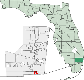
Miramar is a city in southern Broward County, Florida, United States. It is a key suburb of the Miami metropolitan area, which was home to 6.14 million people in 2020. As of the 2020 census, the population was 134,721, making it the second-largest city in Broward County, the fourth-largest city in the Miami metro area, and the 11th-largest city in Florida.

<span class="mw-page-title-main">North Lauderdale, Florida</span> City in Florida

North Lauderdale is a city in Broward County, Florida, United States. It is a principal city of the Miami metropolitan area. As of the 2020 census, the city's population was 44,794.

<span class="mw-page-title-main">Oakland Park, Florida</span> City in Florida, United States

Oakland Park, officially the City of Oakland Park, is a city in Broward County, Florida, United States. It is part of the South Florida metropolitan area, which was home to 6,166,488 people at the 2020 census. As of the 2020 United States Census, the city's population was 44,229.

<span class="mw-page-title-main">Pembroke Park, Florida</span> Town in the state of Florida, United States

Pembroke Park is a town in Broward County, Florida, United States. The town took its name from its location along Pembroke Road. It is part of the South Florida metropolitan area. Almost one-half of its residents live in mobile homes. As of the 2020 census, the population was 6,260.

<span class="mw-page-title-main">Andover, Florida</span> Neighborhood of Miami Gardens in Miami-Dade, Florida, United States

Andover is a neighborhood in Miami Gardens, Florida. It was formerly a census-designated place. The population was 8,489 at the 2000 census. Transmitters for several Miami television stations are located in Andover.

<span class="mw-page-title-main">Bunche Park, Florida</span> Neighborhood of Miami Gardens in Miami-Dade, Florida, United States

Bunche Park is a neighborhood in Miami Gardens, Florida, United States. It was formerly a census-designated place.

<span class="mw-page-title-main">Golden Glades, Florida</span> Census-designated place in Florida

Biscayne Gardens is a census-designated place (CDP) in Miami-Dade County, Florida, United States. It is part of the Miami metropolitan area of South Florida. The population was 32,499 at the 2020 US census.

<span class="mw-page-title-main">Goulds, Florida</span> Census-designated place in Florida

Goulds is an unincorporated community and census-designated place (CDP) in Miami-Dade County, Florida, United States. The area was originally populated as the result of a stop on the Florida East Coast Railroad. The railroad depot was located near the current Southwest 224th Street. The community was named after its operator, Lyman Gould, who cut trees for railroad ties. It is part of the Miami metropolitan area of South Florida. As of the 2020 US census, the population stood at 11,446, up from 10,103 in 2010 US census.

<span class="mw-page-title-main">Lake Lucerne, Florida</span> Neighborhood of Miami Gardens in Miami-Dade, Florida, United States

Lake Lucerne is a neighborhood in Miami Gardens, Florida. It is formerly a census-designated place. The population was 9,132 at the time of the 2000 United States census.

Norland, also known as Norwood, is a former census-designated place located in northern Miami-Dade County, Florida. The population was 22,995 at the 2000 census. The latest estimated population stands at 23,500. In 2003 the majority of this CDP was incorporated into the city of Miami Gardens, and it now serves as one of the city's neighborhoods.

<span class="mw-page-title-main">North Miami Beach, Florida</span> City in Florida

North Miami Beach is a city in Miami-Dade County, Florida, United States. The City of North Miami Beach is part of the Miami metropolitan area of South Florida. Originally named "Fulford-by-the-Sea" in 1926, after Captain William H. Fulford of the U.S. Coast Guard, the city was renamed "North Miami Beach" in 1931. The population was 43,676 at the 2020 US census.

<span class="mw-page-title-main">Opa-locka North, Florida</span> Neighborhood of Miami Gardens in Miami-Dade, Florida, United States

Opa-locka North is a neighborhood in Miami Gardens, Florida, United States. It was formerly a census-designated place. The population was 6,224 at the 2000 census.

<span class="mw-page-title-main">Scott Lake, Florida</span> Neighborhood of Miami Gardens in Miami-Dade, Florida, United States

Scott Lake is a neighborhood in Miami Gardens, Florida. It was formerly its own census-designated place. The population was 14,401 at the 2000 census.

<span class="mw-page-title-main">Atlantis, Florida</span> City in Florida, United States

Atlantis is a city in Palm Beach County, Florida, United States. It is part of the Miami metropolitan area of South Florida. As of the 2020 census, the city had a population of 2,142.

<span class="mw-page-title-main">Highland Beach, Florida</span> Town in the state of Florida, United States

Highland Beach is a town in Palm Beach County, Florida, United States. It is part of the Miami metropolitan area of South Florida, and situated 50 miles north of Miami and 28 miles south of Palm Beach. As of the 2020 US census, the population was 4,295.

<span class="mw-page-title-main">Lake Park, Florida</span> Town in the state of Florida, United States

Lake Park is a town in Palm Beach County, Florida, United States. Lake Park is part of the Miami metropolitan area of South Florida. The population was 9,047 at the 2020 US census.

<span class="mw-page-title-main">Mangonia Park, Florida</span> Town in the state of Florida, United States

Mangonia Park is a town in Palm Beach County, Florida, United States. It is a part of the Miami metropolitan area of South Florida as well as Uptown West Palm, which includes the cities of Riviera Beach and West Palm Beach. As of 2020, the population recorded by the U.S. Census Bureau was 2,142.

<span class="mw-page-title-main">West Park, Florida</span> City in Florida

West Park, officially the City of West Park, is a municipality in Broward County, Florida, United States. It was created on March 1, 2005. West Park is part of Miami metropolitan area of South Florida. It is located in the southeastern part of the county and consists of the neighborhoods of Carver Ranches, Lake Forest, Miami Gardens, and Utopia. A large portion of the city lies west of the town of Pembroke Park, so the new city was called "West Park". The city has a population of 15,130 as of the 2020 census.

References

  1. 1 2 "U.S. Census website". United States Census Bureau . Retrieved 2008-01-31.
  2. Morris, Allan (1995). Florida Place Names: Alachua to Zolfo Springs. Sarasota, Florida: Pineapple Press, Inc. p. 44. ISBN   1-56164-084-0.
  3. 1 2 Garcia-Roberts, Gus. "The Curse." Miami New Times . February 10, 2009. 1. Retrieved on February 11, 2009.
  4. Garcia-Roberts, Gus. "The Curse." Miami New Times . February 10, 2009. 2 Archived 2009-02-20 at the Wayback Machine . Retrieved on February 11, 2009.
  5. Ovalle, David (October 15, 2012). "Pending execution casts spotlight on horrific Miami murder spree in late '70s". The Bradenton Herald . Archived from the original on April 2, 2017. Retrieved May 9, 2022.
  6. "US Gazetteer files: 2010, 2000, and 1990". United States Census Bureau. 2011-02-12. Retrieved 2011-04-23.
  7. "Decennial Census of Population and Housing by Decades". US Census Bureau.
  8. "1990 Census of Population - Summary Social, Economic, and Housing Characteristics - Florida" (PDF). US Census Bureau . 1990.
  9. "2000 Census of Population - General Population Characteristics - Florida" (PDF). United States Census Bureau. 2000.
  10. "Demographics of Carol City, Florida". MuniNetGuide.com. Archived from the original on 2008-04-15. Retrieved 2007-11-04.
  11. "MLA Data Center Results of Carol City, Florida". Modern Language Association . Retrieved 2007-11-04.
  12. "Ancestry Map of Cuban Communities". Epodunk.com. Archived from the original on 2012-11-22. Retrieved 2007-11-04.
  13. "Ancestry Map of Jamaican Communities". Epodunk.com. Archived from the original on 2007-10-11. Retrieved 2007-11-04.
  14. "Ancestry Map of Dominican Communities". Epodunk.com. Archived from the original on 2010-10-17. Retrieved 2007-11-04.
  15. "Ancestry Map of Haitian Communities". Epodunk.com. Archived from the original on 2012-09-23. Retrieved 2007-11-04.
  16. "Ancestry Map of Nicaraguan Communities". Epodunk.com. Archived from the original on 2010-10-17. Retrieved 2007-11-04.
  17. "Ancestry Map of Colombian Communities". Epodunk.com. Archived from the original on 2007-10-11. Retrieved 2007-11-04.
  18. 1 2 3 "Carol City CDP, Florida [ permanent dead link ]." U.S. Census Bureau . Retrieved on September 27, 2009.
  19. "Contact Us Archived 2010-06-20 at the Wayback Machine ." Sandor Weiner School of Opportunity. Retrieved on September 27, 2009.
  20. "Elementary Schools". Roman Catholic Archdiocese of Miami. 2000-10-18. Archived from the original on 2000-10-18. Retrieved 2020-05-10.
  21. "2000 Census Block Map: Carol City CDP" (PDF). U.S. Census Bureau . Retrieved 2020-05-10. - Location with St. Monica is on page 2

Further reading