Carolina Forest, South Carolina

Last updated

Carolina Forest, South Carolina
Carolina Forest Sign.jpg
Sign at the entrance to Carolina Forest at the intersection of US 501 and Carolina Forest Boulevard
USA South Carolina location map.svg
Red pog.svg
Carolina Forest, SC
Usa edcp location map.svg
Red pog.svg
Carolina Forest, SC
Coordinates: 33°45′29″N78°58′1″W / 33.75806°N 78.96694°W / 33.75806; -78.96694
Country United States
State South Carolina
County Horry
Area
[1]
  Total17.29 sq mi (44.77 km2)
  Land16.82 sq mi (43.55 km2)
  Water0.47 sq mi (1.22 km2)
Elevation
39 ft (12 m)
Population
 (2020) [2]
  Total23,342
  Density1,388.17/sq mi (535.97/km2)
Time zone UTC-5 (EST)
ZIP Code
29579 (Myrtle Beach)
Area code 843
FIPS code 45-11833

Carolina Forest is a census-designated place (CDP) in Horry County, South Carolina, United States. It was first listed as a CDP in the 2020 census with a population of 23,342. [3]

Contents

It is located west of Myrtle Beach and east of Conway in an area planned by International Paper in the late 1990s. Most of the development follows the Carolina Forest Master Plan, developed cooperatively between International Paper and the Horry County Government.

Carolina Forest also includes the unincorporated community of Pine Island.

Geography

Carolina Forest is situated west of the Intracoastal Waterway; between U.S. Route 501 and International Drive. Carolina Forest was developed in and around existing Longleaf Pine forests and savannas, within the Waccamaw River watershed, part of the greater lower watershed of the Pee Dee River. The topography of the region between the Waccamaw River and the Intracoastal Waterway is spotted with Carolina Bays, which are elliptical-shaped depressions in the land, often filled with thick vegetation and rich in biodiversity.

History

Carolina Forest was once part of a larger tract of land in eastern Horry County called the Buist Tract. Originally owned by Burroughs & Chapin, International Paper bought the 30,000-acre (121 km2) Buist Tract in 1937. It was used as part of the Conway Bombing and Gunnery Range during World War II. In 1960, the company donated part of the tract for what is now Coastal Carolina University (located several miles away from Carolina Forest). In 1989, approximately 9,000 acres (36 km2) north of Carolina Forest were donated to the state to form the Lewis Ocean Bay Heritage Preserve.

In June 1994, Kylee Mueller sold 125 acres (0.51 km2) of the remaining 21,000 acres (85 km2) of the Buist Tract to Horry County Schools for development of Carolina Forest Elementary School, Carolina Forest Middle School, and Carolina Forest High School. In addition, 350 acres (1.4 km2) were sold to form a golf course and residential property.

By the end of 1994, International Paper began to sell more of its land. Due to the lack of funding from other sources for road infrastructure, the first 1.25 miles (2.01 km) of Carolina Forest Boulevard were completed by November 1995 by International Paper. Further expansions of both Carolina Forest Boulevard and River Oaks Drive (creating an 11-mile (18 km) loop) would open up 11,000 acres (45 km2) to development west of the Intracoastal Waterway. Carolina Forest Boulevard was completed in December 1996, with River Oaks Drive being completed in December 1997. [4]

On December 2, 1997, Horry County council voted to freeze zoning rules in an 11 square miles (28 km2) area of Carolina Forest for 20 years in exchange for land to build parks and roads in an 8–3 vote on the development agreement. An estimated 35,000 people would live in the 7,073 acres (29 km2) covered by the agreement. In the agreement, Horry County did not require International Paper to widen Carolina Forest Boulevard or River Oaks Drive to four lanes. Land would be given to the county at no cost for the then-future SC Highway 31 north and south of the Robert Grissom Parkway bridge. Approximately 140 acres (0.57 km2) was set aside for future schools, which would include Ocean Bay Elementary and Middle Schools. Because nearly half of Carolina Forest was open space, the area was exempt from future open space directives set by Horry County. [5]

According to the 2010 census, Carolina Forest's population increased from 3400 in 2000 to 21,000. [6]

Education

Carolina Forest has a public library, a branch of the Horry County Memorial Library. [7]

Demographics

Historical population
CensusPop.Note
2020 23,342
U.S. Decennial Census [8]
2020 [9] [2]

2020 census

Carolina Forest CDP, South Carolina – Demographic Profile
(NH = Non-Hispanic)
Race / EthnicityPop 2020 [9] % 2020
White alone (NH)17,86776.54%
Black or African American alone (NH)1,8057.73%
Native American or Alaska Native alone (NH)520.22%
Asian alone (NH)6462.77%
Pacific Islander alone (NH)200.09%
Some Other Race alone (NH)1780.76%
Mixed Race/Multi-Racial (NH)1,0764.61%
Hispanic or Latino (any race)1,6987.27%
Total23,342100.00%

Note: the US Census treats Hispanic/Latino as an ethnic category. This table excludes Latinos from the racial categories and assigns them to a separate category. Hispanics/Latinos can be of any race.

Related Research Articles

<span class="mw-page-title-main">Horry County, South Carolina</span> County in South Carolina, United States

Horry County is the easternmost county in the U.S. state of South Carolina. As of the 2020 census, its population was 351,029. It is the fourth-most populous county in South Carolina. The county seat is Conway.

<span class="mw-page-title-main">Georgetown County, South Carolina</span> County in South Carolina, United States

Georgetown County is a county located in the U.S. state of South Carolina. As of the 2020 census, the population was 63,404. Its county seat is Georgetown. The county was founded in 1769. It is named for George III of the United Kingdom.

<span class="mw-page-title-main">Brunswick County, North Carolina</span> County in North Carolina, United States

Brunswick County is the southernmost county in the U.S. state of North Carolina. As of the 2020 census, the population was 136,693. Its population was only 73,143 in 2000, making it one of the fastest-growing counties in the state. With a nominal growth rate of approximately 47% in ten years, much of the growth is centered in the eastern section of the county in the suburbs of Wilmington such as Leland, Belville and Southport. The county seat is Bolivia, which at a population of around 150 people is among the least populous county seats in the state.

<span class="mw-page-title-main">Woodlawn, Baltimore County, Maryland</span> Place in Maryland, United States

Woodlawn is an unincorporated community and census-designated place in Baltimore County, Maryland. Per the 2020 census, the population was 39,986. It is home to the headquarters of the Social Security Administration (SSA) and the Centers for Medicare and Medicaid Services (CMS). It is bordered by Catonsville on the south, by the Patapsco River and Howard County on the west, by Randallstown and Lochearn to the north, and by the City of Baltimore to the east. Parts of Woodlawn are sometimes informally referred to as Security, Maryland, due to the importance of the SSA's headquarters as well as nearby Security Boulevard and Security Square Mall.

<span class="mw-page-title-main">White Oak, Maryland</span> Census-designated place in Maryland, United States

White Oak is a census-designated place and unincorporated area in Montgomery County, Maryland, United States. It had a population of 16,347 in 2020.

<span class="mw-page-title-main">Forest Oaks, North Carolina</span> Census-designated place in North Carolina, United States

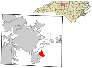
Forest Oaks is a census-designated place (CDP) in Guilford County, North Carolina, United States. The population was 3,890 as of the 2010 census, up from 3,241 in 2000.

<span class="mw-page-title-main">Murrells Inlet, South Carolina</span> Census-designated place in South Carolina, United States

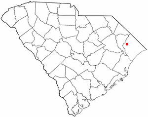
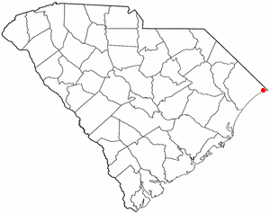
Murrells Inlet is an unincorporated area and census-designated place in Georgetown County, South Carolina, United States. The population was 7,547 at the 2010 census. It is about 13 miles south of Myrtle Beach, South Carolina and 21 miles north of Georgetown, the county seat.

<span class="mw-page-title-main">Aynor, South Carolina</span> Town in South Carolina, United States

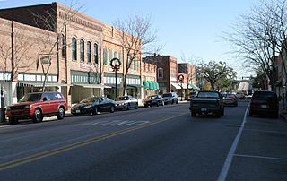
Aynor is a small town in Horry County, South Carolina, United States, south of Galivants Ferry. The population was 560 at the 2010 census and estimated in 2018 to be 934. Aynor High School consistently ranks as one of the best schools in Horry County and South Carolina.

<span class="mw-page-title-main">Briarcliffe Acres, South Carolina</span> Town in South Carolina, United States

Briarcliffe Acres is a town in Horry County, South Carolina, United States, located between Myrtle Beach and North Myrtle Beach. The population was 457 at the 2010 census.

<span class="mw-page-title-main">Bucksport, South Carolina</span> Census-designated place in South Carolina, United States

Bucksport is an unincorporated community and census-designated place (CDP) in Horry County, South Carolina, United States. The population was 876 at the 2010 census. It is a rural port on the Atlantic Intracoastal Waterway at the merger point with the Waccamaw River. The port has some services available for boaters and is also home to the Bucksport Restaurant.

<span class="mw-page-title-main">Conway, South Carolina</span> City in South Carolina, United States

Conway is a city and the county seat of Horry County, South Carolina, United States. The population was 24,849 at the 2020 census, up from 17,103 in the 2010 census, making it the 18th-most populous city in the state. The city is part of the Myrtle Beach metropolitan area. It is the home of Coastal Carolina University.

<span class="mw-page-title-main">Little River, South Carolina</span> CDP in South Carolina, United States

Little River is a census-designated place (CDP) in Horry County, South Carolina, United States. The population was 11,711 at the 2020 census.

<span class="mw-page-title-main">Myrtle Beach, South Carolina</span> City in South Carolina, United States

Myrtle Beach is a resort city on the east coast of the United States in Horry County, South Carolina. It is located in the center of a long and continuous 60-mile (97 km) stretch of beach known as the "Grand Strand” in the northeastern part of the state. Its year-round population was 35,682 as of the 2020 census, making it the 13th-most populous city in South Carolina.

<span class="mw-page-title-main">North Myrtle Beach, South Carolina</span> City in South Carolina, United States

North Myrtle Beach is a city in Horry County, South Carolina, United States. It was created in 1968 from four existing municipalities, and is located about 15 miles (24 km) northeast of Myrtle Beach. It serves as one of the primary tourist destinations along the Grand Strand. As of the 2010 census, the population was 13,752, and in 2019 the estimated population was 16,819. It is part of the Myrtle Beach-Conway-North Myrtle Beach, SC Metropolitan Statistical Area, which had a combined population of 449,295 as of 2016.

<span class="mw-page-title-main">Red Hill, South Carolina</span> Census-designated place in South Carolina, United States

Red Hill is a census-designated place (CDP) in Horry County, South Carolina, United States. The population was 13,223 at the 2010 census, up from 10,509 at the 2000 census.

<span class="mw-page-title-main">Waccamaw River</span> River in the United States of America

The Waccamaw River is a river, approximately 140 miles (225 km) long, in southeastern North Carolina and eastern South Carolina in the United States. It drains an area of approximately 1,110 square miles (2886 km²) in the coastal plain along the eastern border between the two states into the Atlantic Ocean. Along its upper course, it is a slow-moving, blackwater river surrounded by vast wetlands, passable only by shallow-draft watercraft such as canoe. Along its lower course, it is lined by sandy banks and old plantation houses, providing an important navigation channel with a unique geography, flowing roughly parallel to the coast.

<span class="mw-page-title-main">South Carolina Highway 31</span> State highway in South Carolina

South Carolina Highway 31 (SC 31), also known as the Carolina Bays Parkway, is a 28.097-mile (45.218 km) six-lane, limited-access highway that parallels the Intracoastal Waterway around Myrtle Beach. The first phase opened on December 17, 2002, completing a 22-mile (35 km) link between U.S. Route 501 (US 501) and SC 9. The second phase opened in March 2005, running from US 501 southwest to S.C. Highway 544. The third phase opened on November 7, 2019, extending to SC 707. While usually referred to only as the Carolina Bays Parkway, the highway is also dedicated the John B. Singleton Parkway in memory of John B. Singleton, a former Myrtle Beach City Council member and police commissioner.

Dutch Island is an unincorporated community and census-designated place (CDP) in Chatham County, Georgia, United States. It is part of the Savannah Metropolitan Statistical Area, and at the 2020 census, its population was 1,238.

Lewis Ocean Bay Heritage Preserve is a 10,427-acre natural preserve near Carolina Forest, South Carolina.

Live Oak is an unincorporated community and census-designated place (CDP) in Horry County, South Carolina, United States. As of the 2020 census it had a population of 93.

References

  1. "ArcGIS REST Services Directory". United States Census Bureau. Retrieved October 15, 2022.
  2. 1 2 "Census Population API". United States Census Bureau. Retrieved October 15, 2022.
  3. "Carolina Forest CDP, South Carolina". United States Census Bureau . Retrieved April 7, 2022.
  4. "IP Asks Permission to Lengthen Road," Mike Soraghan, The Sun News, July 4, 1996
  5. "Horry County Approves Carolina Forest Pact," Mike Soraghan, The Sun News, December 3, 1997
  6. "Carolina Forest community hoping for benefits from redistricting," Brad Dickerson, The Sun News, June 16, 2011
  7. "Locations & Hours". Greenville County Library System. Retrieved June 8, 2019.
  8. "Decennial Census of Population and Housing by Decades". US Census Bureau.
  9. 1 2 "P2 HISPANIC OR LATINO, AND NOT HISPANIC OR LATINO BY RACE – 2020: DEC Redistricting Data (PL 94-171) – Carolina Forest CDP, South Carolina". United States Census Bureau .