Cassoday, Kansas

Last updated

Cassoday, Kansas
Butler County Kansas Incorporated and Unincorporated areas Cassoday Highlighted.svg
Location within Butler County and Kansas
Map of Butler Co, Ks, USA.png
Coordinates: 38°02′19″N96°38′19″W / 38.03861°N 96.63861°W / 38.03861; -96.63861 [1]
Country United States
State Kansas
County Butler
Incorporated 1960 [2]
Named for John B. Cassoday
Government
[2]
  Type Mayor–Council
   Mayor David Hinde
Area
[3]
  Total0.34 sq mi (0.88 km2)
  Land0.34 sq mi (0.88 km2)
  Water0.00 sq mi (0.00 km2)
Elevation
[1]
1,476 ft (450 m)
Population
 (2020) [4]
  Total113
  Density330/sq mi (130/km2)
Time zone UTC-6 (CST)
  Summer (DST) UTC-5 (CDT)
ZIP code
66842
Area code 620
FIPS code 20-10925
GNIS ID 2393768 [1]

Cassoday is a city in Butler County, Kansas, United States. [1] It is known as the "Prairie Chicken Capital of the World". [5] As of the 2020 census, the population of the city was 113. [4]

Contents

History

Early history

For many millennia, the Great Plains of North America was inhabited by nomadic Native Americans. From the 16th century to 18th century, the Kingdom of France claimed ownership of large parts of North America. In 1762, after the French and Indian War, France secretly ceded New France to Spain, per the Treaty of Fontainebleau.

19th century

In 1802, Spain returned most of the land to France. In 1803, most of the land for modern day Kansas was acquired by the United States from France as part of the 828,000 square mile Louisiana Purchase for 2.83 cents per acre.

In 1854, the Kansas Territory was organized, then in 1861 Kansas became the 34th U.S. state. In 1855, Butler County was established within the Kansas Territory, which included the land for modern day Cassoday.

Cassoday was named for John B. Cassoday, chief justice of the Wisconsin Supreme Court. [6]

The first post office was in Cassoday was established on July 9, 1906. [7]

Geography

Cassoday is located at 38°2′19″N96°38′18″W / 38.03861°N 96.63833°W / 38.03861; -96.63833 (38.038545, -96.638252), [8] in the scenic Flint Hills. According to the United States Census Bureau, the city has a total area of 0.39 square miles (1.01 km2), all of it land. [9]

Climate

The climate in this area is characterized by hot, humid summers and generally mild to cool winters. According to the Köppen Climate Classification system, Cassoday has a humid subtropical climate, abbreviated "Cfa" on climate maps. [10]

Area events

Area attractions

Demographics

Historical population
CensusPop.Note
1970 123
1980 122−0.8%
1990 95−22.1%
2000 13036.8%
2010 129−0.8%
2020 113−12.4%
U.S. Decennial Census

2020 census

The 2020 United States census counted 113 people, 43 households, and 29 families in Cassoday. [14] [15] The population density was 332.4 per square mile (128.3/km2). There were 57 housing units at an average density of 167.6 per square mile (64.7/km2). [15] [16] The racial makeup was 89.38% (101) white or European American (89.38% non-Hispanic white), 0.0% (0) black or African-American, 0.0% (0) Native American or Alaska Native, 0.0% (0) Asian, 0.0% (0) Pacific Islander or Native Hawaiian, 0.88% (1) from other races, and 9.73% (11) from two or more races. [17] Hispanic or Latino of any race was 4.42% (5) of the population. [18]

Of the 43 households, 23.3% had children under the age of 18; 48.8% were married couples living together; 14.0% had a female householder with no spouse or partner present. 25.6% of households consisted of individuals and 7.0% had someone living alone who was 65 years of age or older. [15] The average household size was 2.5 and the average family size was 3.0. [19] The percent of those with a bachelor’s degree or higher was estimated to be 22.1% of the population. [20]

26.5% of the population was under the age of 18, 7.1% from 18 to 24, 17.7% from 25 to 44, 32.7% from 45 to 64, and 15.9% who were 65 years of age or older. The median age was 42.3 years. For every 100 females, there were 82.3 males. [15] For every 100 females ages 18 and older, there were 76.6 males. [15]

The 2016-2020 5-year American Community Survey estimates show that the median household income was $63,750 (with a margin of error of +/- $23,907) and the median family income was $78,750 (+/- $22,763). [21] Males had a median income of $50,625 (+/- $11,417) versus $23,125 (+/- $9,497) for females. The median income for those above 16 years old was $35,357 (+/- $12,820). [22] Approximately, 5.0% of families and 8.8% of the population were below the poverty line, including 21.9% of those under the age of 18 and 0.0% of those ages 65 or over. [23] [24]

2010 census

As of the census [25] of 2010, there were 129 people, 55 households, and 36 families residing in the city. The population density was 330.8 inhabitants per square mile (127.7/km2). There were 70 housing units at an average density of 179.5 per square mile (69.3/km2). The racial makeup of the city was 95.3% White, 1.6% African American, 0.8% Asian, 0.8% Pacific Islander, and 1.6% from two or more races.

There were 55 households, of which 34.5% had children under the age of 18 living with them, 49.1% were married couples living together, 5.5% had a female householder with no husband present, 10.9% had a male householder with no wife present, and 34.5% were non-families. 30.9% of all households were made up of individuals, and 7.2% had someone living alone who was 65 years of age or older. The average household size was 2.35 and the average family size was 2.94.

The median age in the city was 42.8 years. 27.9% of residents were under the age of 18; 7.1% were between the ages of 18 and 24; 17.9% were from 25 to 44; 29.6% were from 45 to 64; and 17.8% were 65 years of age or older. The gender makeup of the city was 51.2% male and 48.8% female.

2000 census

As of the census [26] of 2000, there were 130 people, 54 households, and 36 families residing in the city. The population density was 393.4 inhabitants per square mile (151.9/km2). There were 57 housing units at an average density of 172.5 per square mile (66.6/km2). The racial makeup of the city was 100.00% White. Hispanic or Latino of any race were 3.85% of the population.

There were 54 households, out of which 25.9% had children under the age of 18 living with them, 59.3% were married couples living together, 7.4% had a female householder with no husband present, and 31.5% were non-families. 29.6% of all households were made up of individuals, and 14.8% had someone living alone who was 65 years of age or older. The average household size was 2.41 and the average family size was 3.00.

In the city, the population was spread out, with 26.2% under the age of 18, 5.4% from 18 to 24, 26.9% from 25 to 44, 21.5% from 45 to 64, and 20.0% who were 65 years of age or older. The median age was 37 years. For every 100 females, there were 78.1 males. For every 100 females age 18 and over, there were 84.6 males.

The median income for a household in the city was $41,250, and the median income for a family was $49,688. Males had a median income of $31,875 versus $30,833 for females. The per capita income for the city was $17,807. There were 5.1% of families and 7.8% of the population living below the poverty line, including 19.0% of under eighteens and none of those over 64.

Government

The Cassoday government consists of a mayor and five council members. The council meets once a month. [2]

Education

The community is served by Flinthills USD 492 public school district. The Flinthills High School mascot is Flinthills Mustangs. [27]

Cassoday High School was closed through school unification. The Cassoday High School mascot was Cassoday Longhorns. [28]

Media

Print

Infrastructure

Transportation

K-177 Highway and Southern Transcon main line of BNSF Railway both go through Matfield Green, while the Kansas Turnpike toll road passes immediately north of the city with a toll plaza connected to Cassoday.

Utilities

Fox Lake

See also

Related Research Articles

<span class="mw-page-title-main">Benton, Kansas</span> City in Butler County, Kansas

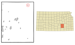
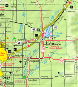
Benton is a city in Butler County, Kansas, United States. As of the 2020 census, the population of the city was 943. It is located northeast of Wichita along K-254 highway.

<span class="mw-page-title-main">Burlington, Kansas</span> City in Coffey County, Kansas, United States

Burlington is a city in and the county seat of Coffey County, Kansas, United States. As of the 2020 census, the population of the city was 2,634.

<span class="mw-page-title-main">Waverly, Kansas</span> City in Coffey County, Kansas

Waverly is a city in Coffey County, Kansas, United States. As of the 2020 census, the population of the city was 574.

<span class="mw-page-title-main">Hepler, Kansas</span> City in Crawford County, Kansas

Hepler is a city in Crawford County, Kansas, United States. As of the 2020 census, the population of the city was 90.

<span class="mw-page-title-main">Jennings, Kansas</span> City in Decatur County, Kansas

Jennings is a city in Decatur County, Kansas, United States. As of the 2020 census, the population of the city was 81.

<span class="mw-page-title-main">Norcatur, Kansas</span> City in Decatur County, Kansas

Norcatur is a city in Decatur County, Kansas, United States. As of the 2020 census, the population of the city was 159.

<span class="mw-page-title-main">Kinsley, Kansas</span> City in Edwards County, Kansas

Kinsley is a city in and the county seat of Edwards County, Kansas, United States. As of the 2020 census, the population of the city was 1,456. It is located along Highway 50.

<span class="mw-page-title-main">Howard, Kansas</span> City in Elk County, Kansas

Howard is a city in and the county seat of Elk County, Kansas, United States. As of the 2020 census, the population of the city was 570.

<span class="mw-page-title-main">Gove City, Kansas</span> City in Gove County, Kansas

Gove City, more commonly known as Gove, is a city in and the county seat of Gove County, Kansas, United States. As of the 2020 census, the population of the city was 80.

<span class="mw-page-title-main">Hamilton, Kansas</span> City in Greenwood County, Kansas

Hamilton is a city in Greenwood County, Kansas, United States. As of the 2020 census, the population of the city was 182.

<span class="mw-page-title-main">Mankato, Kansas</span> City in Jewell County, Kansas

Mankato is a city in and the county seat of Jewell County, Kansas, United States. As of the 2020 census, the population of the city was 836.

<span class="mw-page-title-main">Mission, Kansas</span> City in Kansas, United States

Mission is a city in Johnson County, Kansas, United States, and part of the Kansas City Metropolitan Area. As of the 2020 census, the population of the city was 9,954.

<span class="mw-page-title-main">Kingman, Kansas</span> City in Kingman County, Kansas

Kingman is a city in and the county seat of Kingman County, Kansas, United States. As of the 2020 census, the population of the city was 3,105.

<span class="mw-page-title-main">Lincolnville, Kansas</span> City in Marion County, Kansas

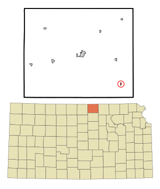
Lincolnville is a city in Marion County, Kansas, United States. As of the 2020 census, the population of the city was 168. The city was named after Abraham Lincoln, the 16th president of the United States. It is located northeast of Marion, west of the intersection of U.S. Route 77 highway and 290th Street next to the Union Pacific Railroad.

<span class="mw-page-title-main">Ramona, Kansas</span> City in Marion County, Kansas

Ramona is a city in Marion County, Kansas, United States. As of the 2020 census, the population of the city was 78. The city name is a Spanish name. It is located southwest of Herington next to a railroad.

<span class="mw-page-title-main">Meade, Kansas</span> City in Meade County, Kansas

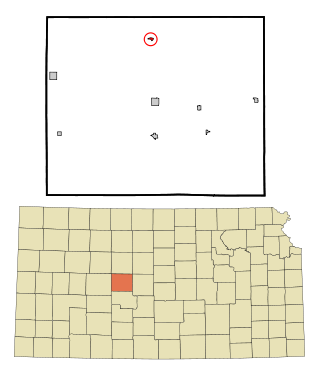
Meade is a city in and the county seat of Meade County, Kansas, United States. As of the 2020 census, the population of the city was 1,505.

<span class="mw-page-title-main">Onaga, Kansas</span> City in Pottawatomie County, Kansas

Onaga is a city in Pottawatomie County, Kansas, United States. As of the 2020 census, the population of the city was 679.

<span class="mw-page-title-main">Agenda, Kansas</span> City in Republic County, Kansas

Agenda is a city in Republic County, Kansas, United States. As of the 2020 census, the population of the city was 47.

<span class="mw-page-title-main">Liebenthal, Kansas</span> City in Rush County, Kansas

Liebenthal is a city in Rush County, Kansas, United States. As of the 2020 census, the population of the city was 92. It is located 8 miles north of La Crosse.

<span class="mw-page-title-main">St. John, Kansas</span> City in Stafford County, Kansas

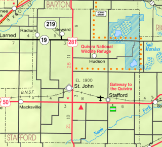
St. John is a city in and the county seat of Stafford County, Kansas, United States. As of the 2020 census, the population of the city was 1,228.

References

  1. 1 2 3 4 U.S. Geological Survey Geographic Names Information System: Cassoday, Kansas
  2. 1 2 3 "Information about City of Cassoday". The League of Kansas Municipalities. Retrieved January 25, 2019.
  3. "2019 U.S. Gazetteer Files". United States Census Bureau. Retrieved July 24, 2020.
  4. 1 2 "Profile of Cassoday, Kansas in 2020". United States Census Bureau. Archived from the original on November 12, 2021. Retrieved November 12, 2021.
  5. 1 2 City of Cassoday
  6. Heim, Michael (2007). Exploring Kansas Highways. p. 12. ISBN   9780974435886.
  7. "Kansas Post Offices, 1828-1961 (archived)". Kansas Historical Society. Archived from the original on October 9, 2013. Retrieved June 5, 2014.
  8. "US Gazetteer files: 2010, 2000, and 1990". United States Census Bureau. February 12, 2011. Retrieved April 23, 2011.
  9. "US Gazetteer files 2010". United States Census Bureau. Archived from the original on July 2, 2012. Retrieved July 6, 2012.
  10. Climate Summary for Cassoday, Kansas
  11. Cassoday Bike Run 1
  12. Cassoday Bike Run 2
  13. Cassoday Bike Run 3 Archived June 15, 2011, at the Wayback Machine
  14. "US Census Bureau, Table P16: HOUSEHOLD TYPE". data.census.gov. Retrieved January 2, 2024.
  15. 1 2 3 4 5 "US Census Bureau, Table DP1: PROFILE OF GENERAL POPULATION AND HOUSING CHARACTERISTICS". data.census.gov. Retrieved January 2, 2024.
  16. Bureau, US Census. "Gazetteer Files". Census.gov. Retrieved December 30, 2023.
  17. "US Census Bureau, Table P1: RACE". data.census.gov. Retrieved January 2, 2024.
  18. "US Census Bureau, Table P2: HISPANIC OR LATINO, AND NOT HISPANIC OR LATINO BY RACE". data.census.gov. Retrieved January 2, 2024.
  19. "US Census Bureau, Table S1101: HOUSEHOLDS AND FAMILIES". data.census.gov. Retrieved January 2, 2024.
  20. "US Census Bureau, Table S1501: EDUCATIONAL ATTAINMENT". data.census.gov. Retrieved January 2, 2024.
  21. "US Census Bureau, Table S1903: MEDIAN INCOME IN THE PAST 12 MONTHS (IN 2020 INFLATION-ADJUSTED DOLLARS)". data.census.gov. Retrieved January 2, 2024.
  22. "US Census Bureau, Table S2001: EARNINGS IN THE PAST 12 MONTHS (IN 2020 INFLATION-ADJUSTED DOLLARS)". data.census.gov. Retrieved January 2, 2024.
  23. "US Census Bureau, Table S1701: POVERTY STATUS IN THE PAST 12 MONTHS". data.census.gov. Retrieved January 2, 2024.
  24. "US Census Bureau, Table S1702: POVERTY STATUS IN THE PAST 12 MONTHS OF FAMILIES". data.census.gov. Retrieved January 2, 2024.
  25. "U.S. Census website". United States Census Bureau . Retrieved July 6, 2012.
  26. "U.S. Census website". United States Census Bureau . Retrieved January 31, 2008.
  27. "Flinthills USD 492". USD 492. Retrieved January 5, 2017.
  28. "Cassoday and Quenemo To State Finals", The Salina Journal, March 13, 1960, p.17.

Further reading