The Potomac River drains the Mid-Atlantic United States, flowing from the Potomac Highlands into Chesapeake Bay. It is 405 miles (652 km) long, with a drainage area of 14,700 square miles (38,000 km2), and is the fourth-largest river along the East Coast of the United States and the 21st-largest in the United States. Over 5 million people live within its watershed.

The Chesapeake and Ohio Canal National Historical Park is located in the District of Columbia and the state of Maryland. The park was established in 1961 as a National Monument by President Dwight D. Eisenhower to preserve the neglected remains of the Chesapeake and Ohio Canal and many of its original structures. The canal and towpath trail extends along the Potomac River from Georgetown, Washington, D.C., to Cumberland, Maryland, a distance of 184.5 miles (296.9 km). In 2013, the path was designated as the first section of U.S. Bicycle Route 50.
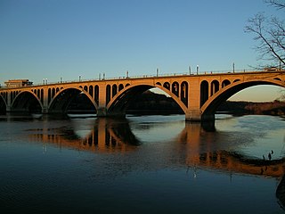
The Francis Scott Key Bridge, more commonly known as the Key Bridge, is a six-lane reinforced concrete arch bridge conveying U.S. Route 29 (US 29) traffic across the Potomac River between the Rosslyn neighborhood of Arlington County, Virginia, and the Georgetown neighborhood of Washington, D.C. Completed in 1923, it is Washington's oldest surviving road bridge across the Potomac River.

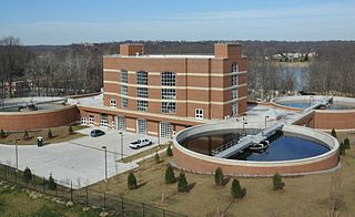
The Washington Aqueduct is an aqueduct that provides the public water supply system serving Washington, D.C., and parts of its suburbs. One of the first major aqueduct projects in the United States, the Aqueduct was commissioned by Congress in 1852, and construction began in 1853 under the supervision of Montgomery C. Meigs and the US Army Corps of Engineers. Portions of the Aqueduct went online on January 3, 1859, and the full pipeline began operating in 1864. The system is owned and operated by the Corps of Engineers and has been in continuous use ever since. It is listed as a National Historic Landmark, and the Union Arch Bridge within the system is listed as a Historic Civil Engineering Landmark.
Dalecarlia Reservoir is the primary storage basin for drinking water in Washington, D.C., fed by an underground aqueduct in turn fed by low dams which divert portions of the Potomac River near Great Falls and Little Falls. The reservoir is located between Spring Valley and the Palisades, two neighborhoods in Northwest Washington, and Brookmont, a neighborhood in Montgomery County, Maryland.

The District of Columbia Water and Sewer Authority provides drinking water, sewage collection and sewage treatment for the District of Columbia, in the United States. The utility also provides wholesale wastewater treatment services to several adjoining municipalities in Maryland and Virginia, and maintains more than 9,000 public fire hydrants in the District of Columbia. DC Water was created in 1996 when the District Government and the U.S. federal government established it as an independent authority of the District government.

East Potomac Park is a park located on a man-made island in the Potomac River in Washington, D.C., United States. The island is between the Washington Channel and the Potomac River, and on it the park lies southeast of the Jefferson Memorial and the 14th Street Bridge. Amenities in East Potomac Park include the East Potomac Park Golf Course, a miniature golf course, a public swimming pool, tennis courts, and several athletic fields. The park is a popular spot for fishing, and cyclists, walkers, inline skaters, and runners heavily use the park's roads and paths. A portion of Ohio Drive SW runs along the perimeter of the park.

The Tidal Basin is a man-made reservoir located between the Potomac River and the Washington Channel in Washington, D.C. It is part of West Potomac Park, is near the National Mall and is a focal point of the National Cherry Blossom Festival held each spring. The Jefferson Memorial, the Martin Luther King Jr. Memorial, the Franklin Delano Roosevelt Memorial, and the George Mason Memorial are situated adjacent to the Tidal Basin. The basin covers an area of about 107 acres (43 ha) and is 10 feet (3.0 m) deep.

The McMillan Reservoir is a reservoir in Washington, D.C. that supplies the majority of the city's municipal water. It was originally called the Howard University Reservoir or the Washington City Reservoir, and was completed in 1902 by the U.S. Army Corps of Engineers.

The Georgetown Reservoir is a reservoir that provides water to the District of Columbia. Part of the city’s water supply and treatment infrastructure, it is located in the Palisades neighborhood, approximately two miles downstream from the Maryland–D.C. boundary.

The Aqueduct Bridge was a bridge between Georgetown, Washington, D.C., and Rosslyn, Virginia. It was built to transport cargo-carrying boats on the Chesapeake and Ohio Canal in Georgetown across the Potomac River to the Alexandria Canal. The same eight piers supported two different bridges: a wooden canal bridge and an iron truss bridge carrying a roadway and an electric trolley line. The bridge was closed in 1923 after the construction of the nearby Key Bridge. The shuttered Aqueduct Bridge was demolished in 1933 though its arched, stone abutment on the Georgetown (north) end is still present and overseen by the National Park Service as an historic site.

The Pennsylvania Avenue Bridge conveys Pennsylvania Avenue across Rock Creek and the adjoining Rock Creek and Potomac Parkway, between the neighborhoods of Georgetown and Foggy Bottom in Northwest Washington, D.C. Pennsylvania Avenue terminates at M Street immediately west of the bridge.

Little Falls Branch, a 3.8-mile-long (6.1 km) tributary stream of the Potomac River, is located in Montgomery County, Maryland. In the 19th century, the stream was also called Powder Mill Branch. It drains portions of Bethesda, Somerset, Friendship Heights, and the District of Columbia, flows under the Chesapeake and Ohio Canal (C&O), and empties into the Potomac at Little Falls rapids, which marks the upper end of the tidal Potomac.
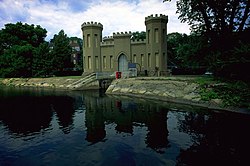
The Union Arch Bridge, also called the "Cabin John Bridge", is a historic masonry structure in Cabin John, Maryland. It was designed as part of the Washington Aqueduct. The bridge construction began in 1857 and was completed in 1864. The roadway surface was added later. The bridge was designed by Alfred Landon Rives, and built by the United States Army Corps of Engineers under the direction of Lieutenant Montgomery C. Meigs.

The Framingham Reservoir No. 1 Dam and Gatehouse is a historic water works facility in Framingham, Massachusetts. This complex is located at the end of Framingham Reservoir No. 1, which is also known as the Stearns Reservoir, off Winter Street and north of Long Avenue. Constructed from 1876 to 1878 as part of an expansion of the water supply of the city of Boston, this was designed by its first city architect George A. Clough. The historical purpose of the reservoir, which was located at the confluence of two branches of the Sudbury River, was primarily to control the river's water level, and secondarily to provide reserve supply capacity. The reservoir's reserve capacity was generally used only as a backup supply, as the reservoir's muddy bottom made it a less desirable source than reservoir No. 3 upstream. However the reservoir No. 1 system was nonetheless important due to its role in controlling the flow of the river downstream, and due to the gatehouse which controlled the water flows for all the Framingham reservoirs into the Sudbury Aqueduct. Reservoir No. 1 is no longer maintained as a reserve water source, although it is still owned by the Massachusetts Water Resources Authority, successor to the Boston Water Board which oversaw its construction. MWRA retains ownership as the gatehouse contains the connection between Reservoir No. 3 and the Sudbury Aqueudct which remain part of the emergency water systems.

The Sudbury Aqueduct is an aqueduct in Massachusetts. It runs for 16 miles (26 km) from Farm Pond at Waverly Street in Framingham to Chestnut Hill Reservoir in Boston’s Chestnut Hill neighborhood. A later built extension main runs from the Farm Pond gatehouse to the gatehouse at the Stearns Reservoir where additional mains connect to the Brackett and Foss Reservoirs Going east from Framingham, it runs through Sherborn before entering Natick. From Natick it runs east through Wellesley and Needham to the Charles River, which it crosses on the Echo Bridge into Newton. It ends at the Chestnut Hill Reservoir on the Newton side of the Newton-Boston line. The Massachusetts Water Resources Authority (MWRA) operates the aqueduct.

The Middlesex Fells Reservoirs Historic District is a historic district roughly bounded by Pond St., Woodland Rd., I-93, and MA 28 in Stoneham and Medford, Massachusetts. It encompasses a portion of the Middlesex Fells Reservation, a state park managed by the Massachusetts Department of Conservation and Recreation (DCR). The principal features of the district are three reservoirs and their associated gate houses and pumping stations, which were developed by the Metropolitan District Commission starting in the late 19th century. The district was listed on the National Register of Historic Places in 1990.

McMillan Sand Filtration Site is a twenty-five acre decommissioned water treatment plant in northwest Washington, D.C., built as part of the historic McMillan Reservoir Park. It is bound on the north by Michigan Avenue, on the east by North Capitol Street, on the south by Channing Street and on the west by McMillan Drive; which runs along the edge of the reservoir, to which it was formerly attached. Two paved courts lined by regulator houses, tower-like sand bins, sand washers and the gated entrances to the underground filter cells provided a promenade for citizens taking the air in the park before it was fenced off in WWII.

The Washington Canoe Club is a boat club on the Potomac River. It is located at 3700 K Street, Northwest, Washington, D.C., in the Georgetown neighborhood. It was established in 1904. The Canoe Club was listed in the National Register of Historic Places in on March 19, 1991.