Cathedral Peak (California)

Last updated
Cathedral Peak
File-Yosemite 58 bg 090504.jpg
Cathedral Peak
Highest point
Elevation 10,916 ft (3,327 m)  NAVD 88 [1]
Prominence 919 ft (280 m) [1]
Listing SPS Mountaineers peak [2]
Coordinates 37°50′52″N119°24′20″W / 37.8478289°N 119.4056214°W / 37.8478289; -119.4056214 [3]
Geography
Location Yosemite National Park, California, U.S.
Parent range Cathedral Range, Sierra Nevada
Topo map USGS Tenaya Lake
Geology
Age of rock Cretaceous
Mountain type Granite arête
Climbing
First ascent 1869 by John Muir [4]
Easiest route Rock climb class 4 [2]
Cathedral Peak from near Cathedral Lakes, with Eichorn Pinnacle in the foreground. The spiny crown of Cathedral Peak, Yosemite National Park, California.jpg
Cathedral Peak from near Cathedral Lakes, with Eichorn Pinnacle in the foreground.

Cathedral Peak is part of the Cathedral Range, a mountain range in the south-central portion of Yosemite National Park in eastern Mariposa and Tuolumne Counties. The range is an offshoot of the Sierra Nevada. The peak which lends its name to the range derives its name from its cathedral-shaped peak, which was formed by glacial activity: the peak remained uneroded above the glaciers in the Pleistocene.

Contents

Geography

Cathedral Peak has a subsidiary summit to the west called Eichorn Pinnacle, for Jules Eichorn, who first ascended a class 5.4 route to its summit on July 24, 1931, with Glen Dawson.

In 1869, John Muir wrote in My first summer in the Sierra:

The body of the Cathedral is nearly square, and the roof slopes are wonderfully regular and symmetrical, the ridge trending northeast and southwest. This direction has apparently been determined by structure joints in the granite. The gable on the northeast end is magnificent in size and simplicity, and at its base there is a big snow-bank protected by the shadow of the building. The front is adorned with many pinnacles and a tall spire of curious workmanship. Here too the joints in the rock are seen to have played an important part in determining their forms and size and general arrangement. The Cathedral is said to be about eleven thousand feet above the sea, but the height of the building itself above the level of the ridge it stands on is about fifteen hundred feet. A mile or so to the westward there is a handsome lake, and the glacier-polished granite about it is shining so brightly it is not easy in some places to trace the line between the rock and water, both shining alike. [5]

Cathedral Peak, looking southwest across Tuolumne Meadows. CathedralPeakCA.jpg
Cathedral Peak, looking southwest across Tuolumne Meadows.

Geology

The Cathedral Peak Granodiorite of Cathedral Peak is an intrusion into an area of older intrusive (or plutonic) and metamorphic rock in the Sierra Nevada Batholith. It is part of a grouping of intrusions called the Tuolumne Intrusive Suite. Cathedral Peak is the youngest of the rock formations in the Suite, dating to the Cretaceous Period at 83 million years ago. Its composition is mainly granodiorite with phenocrysts of microcline. [6]

Cathedral Peak was a nunatak during the Tioga glaciation of the last ice age, the peak projected above the glaciers, which carved and sharpened the peak's base while plucking away at its sides. [7] [8] [9] [10]

See also

Related Research Articles

<span class="mw-page-title-main">Tuolumne Meadows</span> Meadow in Yosemite National Park, US

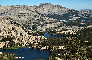
Tuolumne Meadows is a gentle, dome-studded, sub-alpine meadow area along the Tuolumne River in the eastern section of Yosemite National Park in the United States. Its approximate location is 37°52.5′N119°21′W. Its approximate elevation is 8,619 feet (2,627 m). The term Tuolumne Meadows is also often used to describe a large portion of the Yosemite high country around the meadows, especially in context of rock climbing.

<span class="mw-page-title-main">Cathedral Range</span> Mountain range in Yosemite National Park, California

The Cathedral Range is a mountain range immediately to the south of Tuolumne Meadows in Yosemite National Park. The range is an offshoot of the Sierra Nevada. The range is named after Cathedral Peak, which resembles a cathedral spire.

<span class="mw-page-title-main">Geology of the Yosemite area</span>

The exposed geology of the Yosemite area includes primarily granitic rocks with some older metamorphic rock. The first rocks were laid down in Precambrian times, when the area around Yosemite National Park was on the edge of a very young North American continent. The sediment that formed the area first settled in the waters of a shallow sea, and compressive forces from a subduction zone in the mid-Paleozoic fused the seabed rocks and sediments, appending them to the continent. Heat generated from the subduction created island arcs of volcanoes that were also thrust into the area of the park. In time, the igneous and sedimentary rocks of the area were later heavily metamorphosed.

<span class="mw-page-title-main">Mount Lyell (California)</span> Mountain in the American state of California

Mount Lyell is the highest point in Yosemite National Park, at 13,114 feet (3,997 m). It is located at the southeast end of the Cathedral Range, 1+14 miles northwest of Rodgers Peak. The peak as well as nearby Lyell Canyon is named after Charles Lyell, a well-known 19th century geologist. The peak had one of the last remaining glaciers in Yosemite, Lyell Glacier. The Lyell Glacier is currently considered to be a permanent ice field, not a living glacier. Mount Lyell divides the Tuolumne River watershed to the north, the Merced to the west, and the Rush Creek drainage in the Mono Lake Basin to the southeast.

<span class="mw-page-title-main">Geography of the Yosemite area</span>

Yosemite National Park is located in the central Sierra Nevada of California. Three wilderness areas are adjacent to Yosemite: the Ansel Adams Wilderness to the southeast, the Hoover Wilderness to the northeast, and the Emigrant Wilderness to the north.

<span class="mw-page-title-main">Jules Eichorn</span> American mountaineer, environmentalist and music teacher

Jules Marquard Eichorn was an American mountaineer, environmentalist, and music teacher.

<span class="mw-page-title-main">Cathedral Peak Granodiorite</span> Suite of intrusive rock in the Sierra Nevada

The Cathedral Peak Granodiorite (CPG) was named after its type locality, Cathedral Peak in Yosemite National Park, California. The granodiorite forms part of the Tuolumne Intrusive Suite, one of the four major intrusive suites within the Sierra Nevada. It has been assigned radiometric ages between 88 and 87 million years and therefore reached its cooling stage in the Coniacian.

<span class="mw-page-title-main">Glen Dawson (climber)</span> American mountain climber

Glen Dawson was an American rock climber, mountaineer, antiquarian bookseller, publisher and environmentalist.

<span class="mw-page-title-main">Vogelsang Pass</span> Mountain pass in Yosemite National Park

Vogelsang Pass is a mountain pass in the Cathedral Range of Yosemite National Park, at 10,680 ft (3,260 m). It lies between the cirque containing Vogelsang Lake and the valley with Lewis Creek. The pass also lies on the ridge between Fletcher Peak and Vogelsang Peak.

<span class="mw-page-title-main">Matthes Crest</span> Mountain in the American state of California

Matthes Crest is an approximately mile-long fin of rock with two summits separated by a deep notch. It is a part of the Cathedral Range, which is a mountain range in the south-central portion of Yosemite National Park. The range is part of the Sierra Nevada.

<span class="mw-page-title-main">Half Dome Granodiorite</span> Half Dome Granodiorite is granodiorite (see also granite) found in Yosemite National Park

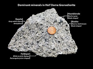
Half Dome Granodiorite is granodiorite found in a region on and near Half Dome, in Yosemite National Park, California, United States. The granodiorite forms part of the Tuolumne Intrusive Suite, one of the four major intrusive suites within the Sierra Nevada.

<span class="mw-page-title-main">El Capitan Granite</span> El Capitan Granite is a type of granite (also see granodiorite), Yosemite National Park

El Capitan Granite is a type of granite, in a large area near El Capitan, in Yosemite National Park, California, United States. The granite forms part of the Tuolumne Intrusive Suite, one of the four major intrusive suites within the Sierra Nevada.

<span class="mw-page-title-main">Kuna Crest Granodiorite</span> Kuna Crest Granodiorite, Granodiorite of Glen Aulin is a granodiorite found Yosemite National Park

Kuna Crest Granodiorite, is found, in Yosemite National Park, United States. The granodiorite forms part of the Tuolumne Intrusive Suite, one of the four major intrusive suites within the Sierra Nevada. Of the Tuolumne Intrusive Suite, it is the oldest and darkest rock.

<span class="mw-page-title-main">Sentinel granodiorite</span> Sentinel granodiorite is a type of granodiorite found Yosemite National Park


Sentinel granodiorite is a type of granodiorite found in Yosemite National Park. It is a poorly understood western "outlier" of the ~93-85-Ma Tuolumne Intrusive Suite of the Sierra Nevada batholith. It is only slightly older than the undated Yosemite Creek Granodiorite and the Kuna Crest Granodiorite.

<span class="mw-page-title-main">Tuolumne Intrusive Suite</span> One of several intrusive suites in Yosemite National Park

The Tuolumne Intrusive Suite is the youngest and most extensive of the intrusive suites of Yosemite National Park, and also comprises about 1/3 of the park's area. The Suite includes Half Dome Granodiorite, Cathedral Peak Granite, and Kuna Crest Granodiorite.

<span class="mw-page-title-main">Hiking, rock climbing, and mountain climbing around Tuolumne Meadows</span>

Hiking, rock climbing, and mountain climbing around Tuolumne Meadows in Yosemite National Park has many options.

<span class="mw-page-title-main">Tuolumne Peak</span> Tuolumne Peak is mountain peak, in Yosemite National Park, in the Tuolumne Meadows area

Tuolumne Peak is a mountain, in Yosemite National Park, in the area of Tuolumne Meadows. It is a fractured granite, twin summited peak, and is close to geographic center of the park. Tuolumne Peak is located approximately 2.5 miles (4.0 km) northeast of Mount Hoffmann via a granite ridge-line. It is climbed less often than Hoffman, probably due to a more difficult approach.

<span class="mw-page-title-main">Kuna Crest</span> Mountain range near Tuolumne Meadows, in Yosemite National Park, California

Kuna Crest is a mountain range near Tuolumne Meadows, in Yosemite National Park, California.

<span class="mw-page-title-main">Finger Peaks</span> Mountain in the state of California

Finger Peaks is a granitic mountain summit with an elevation of 11,498 feet (3,505 m) located in the Sierra Nevada mountain range, in northern California, United States. The three peaks are situated in Yosemite National Park and Tuolumne County. The landform is set immediately west of Burro Pass, 1.5 mile south of Eocene Peak, and 1.4 mile southwest of Matterhorn Peak. Topographic relief is significant as the summit rises 1,700 feet above Piute Creek in one-half mile. The first ascent of the summit was made July 19, 1931, by Jules Eichorn, Glen Dawson, and Walter Brem. This landform's toponym has been in publications since at least 1925, and was officially adopted by the U.S. Board on Geographic Names in 1932.

Johnson Granite Porphyry is found in Tuolumne Meadows, Yosemite National Park.

References

  1. 1 2 "Cathedral Peak, California". Peakbagger.com. Retrieved 2009-01-15.
  2. 1 2 "Sierra Peaks Section List" (PDF). Angeles Chapter, Sierra Club . Retrieved 2009-01-15.
  3. "Cathedral Peak". Geographic Names Information System . United States Geological Survey, United States Department of the Interior . Retrieved 2009-01-15.
  4. Farquhar, Francis P. (1926). Place Names of the High Sierra. San Francisco: Sierra Club . Retrieved 2009-01-15.
  5. Muir, John (1911). My first summer in the Sierra. Sierra Club Books. OCLC   319448481.
  6. Wahrhaftig, Clyde (2000). "Geologic Map of the Tower Peak Quadrangle, Central Sierra Nevada, California" (PDF). U.S. Geological Survey. Retrieved 2009-01-15.
  7. "Geologic Resources Inventory Report" (PDF). Yosemite National Park. 2012. Natural Resource Report NPS/NRSS/GRD/NRR—2012/560. Archived from the original (PDF) on 2017-02-12. Retrieved 2016-03-26.
  8. "Upper Cathedral Lakes". Yosemite Hikes.
  9. Huber, N. King (1987). "The Geologic Story of Yosemite National Park". The Geologic Story of Yosemite National Park. yosemite.ca.us. Retrieved 7 February 2019.
  10. Gregory, Candace (September 10, 2017). "Hiking up the Glacier Canyon Trail to Dana Plateau". Hiking up the Glacier Canyon Trail to Dana Plateau. sierranewsonline.com. Retrieved 7 February 2019.