Cay Sal

Last updated
Cay Sal
Cayo de Sal
island
Bahamas location map.svg
Cercle rouge 100%25.svg
Cay Sal (Bahamas)
Cay Sal.png
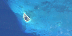
View of the island from above
Country The Bahamas
Region Bahama Banks
District Bimini
Area
  Total1.22 km2 (0.47 sq mi)
Population
  Total0
  Density0.0/km2 (0.0/sq mi)
Languages
  Official English
Time zone UTC−5 (EST)

Cay Sal (Spanish : Cayo de Sal) [1] is a small island in the Cay Sal Bank between Florida, Cuba, and the Bahamas. It is no longer inhabited.

Contents

The Bahamas have an agreement with the U.S. Coast Guard to regularly fly over Cay Sal and other islands in the bank to look for people potentially stranded there. [2] [3]

Geography

Cay Sal is the main island in the southwestern zone of the Cay Sal Bank. It is 1.6 km (1.0 mi) in length and 1.22 km2 (0.47 sq mi) in area.

The island is covered with stunted palm trees and marked by several dilapidated buildings standing on its western side. In its interior there is a large salt pond commonly replenished by heavy wind-driven seas that broach the islet along its southwest side.

History

According to Spanish navigators the island had a few natural salt pans producing good, clean salt, and its leeward side provided an excellent anchorage as well. [1]

From the 1960s to late 1970s the Royal Bahamas Defence Force kept a small outpost on Cay Sal island, which also had an airstrip. [4] Another island in the banks, Elbow Cays, has a lighthouse built in 1839 by the British. [5]

The United States Coast Guard constantly monitors Cay Sal and nearby islands for refugees from Cuba. [6] [ needs update ] Cay Sal is about thirty miles away from Cuba. [7] Refugees rescued on the island have included pregnant women and children. Refugees are reported to have employed a variety of craft including small, ill-equipped boats, in spite of the possibility of pursuit by the Cuban military. [8]

In 2023, the Coast Guard rescued a man who had been stranded on the island for 3 days. [9]

See also

Related Research Articles

This article talks about transportation in the Bahamas, a North American archipelagic state in the Atlantic Ocean.

<span class="mw-page-title-main">Abaco Islands</span> Group of islands in the Bahamas

The Abaco Islands lie in the northern Bahamas, located about 193 miles east of Miami, Florida. The main islands are Great Abaco and Little Abaco. There are several smaller barrier cays, of which the northernmost are Walker's Cay and its sister island Grand Cay. To the south, the next inhabited islands are Spanish Cay and Green Turtle Cay, with its settlement of New Plymouth, Great Guana Cay, private Scotland Cay, Man-O-War Cay, and Elbow Cay, with its settlement of Hope Town. Southernmost are Tilloo Cay and Lubbers Quarters. Another of note off Abaco's western shore is Gorda Cay, now a Disney-owned island and a cruise ship stop renamed Castaway Cay. Also in the vicinity is Moore's Island. On the Big Island of Abaco is Marsh Harbour, the Abacos' commercial hub and the Bahamas' third largest city, plus the resort area of Treasure Cay. Both have airports. A few mainland settlements of significance are Coopers Town and Fox Town in the north and Cherokee and Sandy Point in the south. Administratively, the Abaco Islands constitute seven of the 31 Local Government Districts of the Bahamas: Grand Cay, North Abaco, Green Turtle Cay, Central Abaco, South Abaco, Moore's Island, and Hope Town.

<span class="mw-page-title-main">Ragged Island, Bahamas</span> Island in Bahamas

Ragged Island is a 23 km2 (8.9 sq mi) island and district in the southern Bahamas. Ragged Island is part of the Jumentos Cays and Ragged Island Chain. The crescent-shaped chain measures over 180 km (110 mi) in length and includes cays known as Raccoon Cay, Hog Cay and Double-Breasted Cay. Island ownership is stated to have been granted to William George Lockhart some time in the 18th century. On 8 September 2017, Duncan Town took a direct hit from Hurricane Irma.

<span class="mw-page-title-main">Guanahani</span> Island in the Bahamas which Christopher Columbus landed on

Guanahaní was the Taíno name of an island in the Bahamas that was the first land in the New World sighted and visited by Christopher Columbus' first voyage, on 12 October 1492. It is a bean-shaped island that Columbus called San Salvador. Guanahaní has traditionally been identified with Watlings Island, which was officially renamed San Salvador Island in 1925 as a result, but modern scholars are divided on the accuracy of this identification and several alternative candidates in and around the southern Bahamas have been proposed as well.

<span class="mw-page-title-main">Elbow Cay</span> Eight-mile-long (13-kilometre) cay in the Abaco Islands of the Bahamas

Elbow Cay is an eight-mile-long (13-kilometre) cay in the Abaco Islands of the Bahamas. Originally populated by British loyalists fleeing the newly independent United States of America in 1785, it has survived on fishing, boat building, and salvage. Its main village of Hope Town surrounds a protected harbor with a noted red-and-white-striped one-hundred-and-twenty-foot-tall (37-metre) lighthouse built in 1863. On September 1, 2019, Elbow Cay took a direct hit from Category 5 Hurricane Dorian, with sustained winds of 185 mph (295 km/h). The lighthouse survived.

<span class="mw-page-title-main">Great Stirrup Cay</span> Island in Bahamas

Great Stirrup Cay is a 268-acre (108 ha) island that is part of the Berry Islands in the Bahamas. Norwegian Cruise Line purchased the island from the Belcher Oil Company in 1977 and developed it into a private island for their cruise ship passengers. The northern part of the island has a sandy beach surrounded by rocks with snorkeling areas. The southern part features a helicopter airfield, a large area without vegetation, and numerous concrete blocks. These are all remnants of a previous U.S. military installation and satellite tracking station. The island's lighthouse was originally constructed in 1863 by the Imperial Lighthouse Service. Great Stirrup Cay is adjacent to Little Stirrup Cay, Royal Caribbean Cruises' private island.

SLNS <i>Samudura</i> (P261) United States Coast Guard medium endurance cutter

SLNS Samudura (P621) is a Sri Lanka Navy Offshore Patrol Vessel. Originally commissioned by the United States Coast Guard in 1968 as the medium endurance cutter USCGC Courageous, she was donated to Sri Lanka in 2004 and commissioned on February 19, 2005.

<span class="mw-page-title-main">Nicholas Channel</span> Strait between Cuba and the Bahamas

Nicholas Channel is a strait off the northeastern coast of Cuba. It lies 90 miles (140 km) east of Havana. It separates Cuba from the most southwestern of the islands of the Bahamas.

<span class="mw-page-title-main">Cay Sal Bank</span> Carbonate platform in Bahama Banks, The Bahamas

Cay Sal Bank is the third largest and the westernmost of the Bahama Banks. It is located between 23º27'N - 24º10'N and 079º25'W – 080º35'W. In a geographical sense, it is separate from the Bahamas proper as it is much closer to Cuba than to the closest Bahamian island. It is separated by Santaren Channel from the Great Bahama Bank, the western rim of which is 50 km (31 mi) to the east. The Straits of Florida separate it from the United States mainland and the Florida Keys.

USCGC <i>Androscoggin</i>

USCGC Androscoggin (WHEC-68) was an Owasco-class high endurance cutter built for World War II service with the United States Coast Guard. The war ended before the ship was completed and consequently Androscoggin did not see wartime service until the Vietnam war.

<span class="mw-page-title-main">Outline of the Bahamas</span> Overview of and topical guide to The Bahamas

The following outline is provided as an overview of and topical guide to The Bahamas:

<span class="mw-page-title-main">Hurricane Fox (1952)</span> Category 4 Atlantic hurricane in 1952

Hurricane Fox was the strongest and deadliest tropical cyclone of the below average 1952 Atlantic hurricane season. The seventh tropical storm, sixth Atlantic hurricane, and the third major hurricane of the season, Fox was a small and intense Caribbean storm that developed northwest of Cartagena, Colombia, in the southern Caribbean. It moved steadily northwest, intensifying to a tropical storm on October 21. The next day, it rapidly strengthened into a hurricane and turned north passing closely to Grand Cayman, Cayman Islands. The cyclone attained peak winds of 145 mph (233 km/h) as it struck Cayo Guano del Este off the coast of Cienfuegos. Fox made landfall on Cuba at maximum intensity, producing peak gusts of 170–180 mph (270–290 km/h). It weakened over land, but it re-strengthened as it turned east over the Bahamas. On October 26, it weakened and took an erratic path, dissipating west-southwest of Bermuda on October 28.

<span class="mw-page-title-main">Old Bahama Channel</span> Strait between Cuba and the Bahamas

The Old Bahama Channel is a strait of the Caribbean region, between Cuba and the Bahamas.

<span class="mw-page-title-main">Index of the Bahamas–related articles</span>

The following is an alphabetical list of topics related to the Commonwealth of The Bahamas.

USCGC <i>Point Thatcher</i> United States Coast Guard cutter

USCGC Point Thatcher (WPB-82314) was an 82-foot (25 m) Point class cutter constructed at the Coast Guard Yard at Curtis Bay, Maryland in 1961 for use as a law enforcement and search and rescue patrol boat. Since the Coast Guard policy in 1961 was not to name cutters under 100 feet (30 m) in length, it was designated as WPB-82314 when commissioned and acquired the name Point Thatcher in January 1964 when the Coast Guard started naming all cutters longer than 65 feet (20 m). Point Thatcher was unique because it was the only cutter that was built in the class that was powered using gas turbine main drive engines.

<span class="mw-page-title-main">Long Island, Bahamas</span> Place in Long Island, Bahamas

Long Island is an island in The Bahamas that is split by the Tropic of Cancer. It is one of the Districts of the Bahamas and is known as the most scenic island in the Bahamas. Its capital is Clarence Town. The population of Long Island is 3,094 inhabitants.

<span class="mw-page-title-main">Hurricane Joaquin</span> Category 4 Atlantic hurricane in 2015

Hurricane Joaquin was a powerful tropical cyclone that devastated several districts of The Bahamas and caused damage in the Turks and Caicos Islands, parts of the Greater Antilles, and Bermuda. It was also the strongest Atlantic hurricane of non-tropical origin recorded in the satellite era. The tenth named storm, third hurricane, and second major hurricane of the 2015 Atlantic hurricane season, Joaquin evolved from a non-tropical low to become a tropical depression on September 28, well southwest of Bermuda. Tempered by unfavorable wind shear, the depression drifted southwestward. After becoming a tropical storm the next day, Joaquin underwent rapid intensification, reaching hurricane status on September 30 and Category 4 major hurricane strength on October 1. Meandering over the southern Bahamas, Joaquin's eye passed near or over several islands. On October 3, the hurricane weakened somewhat and accelerated to the northeast. Abrupt re-intensification ensued later that day, and Joaquin acquired sustained winds of 155 mph (250 km/h), just short of Category 5 strength.

USCGC <i>Isaac Mayo</i>

USCGC Isaac Mayo is a Sentinel-class cutter homeported in Key West, Florida. She is the twelfth Sentinel class to be delivered, and the sixth of six to be assigned to Key West.

<span class="mw-page-title-main">Elbow Cays</span> Cays in The Bahamas

The Elbow Cays are uninhabited cays in the Cay Sal Bank, Bahamas. It is the most Western point in the Bahamas. They are part of a reef shelf located at the northwestern end of the bank about 80 km (50 mi) off the Cuban coast and 130 km (80 mi) southeast of Key West, Florida. These cays are an excellent scuba diving spot.

References

  1. 1 2 Derrotero de las islas Antillas, de las costas Tierra-Firme, y las del Seno Mejicano, Dirección de Hidrografía, España, Madrid, Imprenta Nacional, 1837. p. 266
  2. "Man rescued from Cay Sal Bank". Archived from the original on 2015-02-21. Retrieved 2015-02-21.
  3. "Coast Guard rescues man stranded on Cay Sal". United States Coast Guard News. Retrieved 2023-08-23.
  4. Cay Sal Bank Lighthouse: A Stately Ruin
  5. Cay Sal Bank Lighthouse: A Stately Ruin
  6. Rome News-Tribune - Apr 19, 1964
  7. Rome News-Tribune - Apr 19, 1964
  8. Rome News-Tribune - Apr 19, 1964
  9. "Coast Guard rescues man stranded on Cay Sal". United States Coast Guard News. Retrieved 2023-08-24.