
Cedar Island is an island and unincorporated community in Carteret County, North Carolina, United States. [1] In 2005, the population was estimated to be 350. The ZIP Code for Cedar Island is 28520. [2]
Cedar Island is an island and unincorporated community in Carteret County, North Carolina, United States. [1] In 2005, the population was estimated to be 350. The ZIP Code for Cedar Island is 28520. [2]
Cedar Island was home to a local Native American population prior to the arrival of European settlers.
In 2019, Hurricane Dorian brought 9 feet of storm surge over the island and damaged one-third of the buildings. 28 feral horses and approximately 15 feral (or abandoned) cows were swept away. Three cows were later found on North Core Banks, having swam at least four miles, but possibly up to 40 miles after being in the water for 12-24 hours. [3] [4] [5]
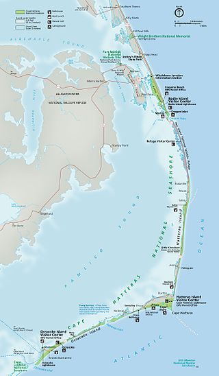
There are only two main roads within Cedar Island. Northbound NC-12 is the only way to access Cedar Island without using a ferry connection. This crosses the Monroe Gaskill Memorial Bridge. [3] [6]
Southbound NC-12 continues from the ferry terminal across Cedar Island to meet with U.S. Route 70 on the mainland, near the community of Sea Level.
The Cedar Island ferry terminal provides access to Swan Quarter and Ocracoke Island, both across the Pamlico Sound.
Many residents are fishermen, though fishing is declining in the area. The other major employer is the North Carolina Ferry System. There are three churches on the island: Methodist, Free Will Baptist, and Primitive Baptist. The Methodist and Free Will Baptist maintain regular meetings and Sunday services. There are a few local businesses.
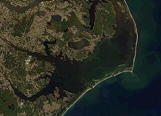
Cedar Island is about 4 miles (6.4 km) long, extending from the "Lola" village, down the bay, on the southeast end near the Core Sound and Lewis Creek, up to the Ferry Station at the north side of the island, bordering Pamlico Sound. The main village of Cedar Island, formerly known as "Roe" is located along the north central portion of the island. There is a fisherman's harbor in this area.
Cedar Island has sandy beaches backed up against stands of Juniper, Cedar and pine. More than half of Cedar Island belongs to the (Federal) Cedar Island Wildlife Refuge. [7] The refuge is open for hiking and has a headquarters and information kiosk at the south end of the island, near the end of Lola Road. There are boat ramps for public use.
The climate of Cedar Island is cooler than inland areas in the summer and warmer in the winter, and it is occasionally hit by hurricanes in the fall. Temperatures do not often fall below freezing (32°F) in the winter, nor do they often rise above 90°F in the summer.
| Climate data for Cedar Island, North Carolina (1981–2010 normals, extremes 1955–present) | |||||||||||||
|---|---|---|---|---|---|---|---|---|---|---|---|---|---|
| Month | Jan | Feb | Mar | Apr | May | Jun | Jul | Aug | Sep | Oct | Nov | Dec | Year |
| Record high °F (°C) | 86 (30) | 85 (29) | 88 (31) | 95 (35) | 98 (37) | 101 (38) | 103 (39) | 102 (39) | 98 (37) | 98 (37) | 85 (29) | 81 (27) | 103 (39) |
| Average high °F (°C) | 56.4 (13.6) | 59.4 (15.2) | 66.1 (18.9) | 74.9 (23.8) | 82.1 (27.8) | 88.8 (31.6) | 91.8 (33.2) | 89.9 (32.2) | 84.8 (29.3) | 76.5 (24.7) | 67.6 (19.8) | 59.4 (15.2) | 74.8 (23.8) |
| Daily mean °F (°C) | 45.2 (7.3) | 47.8 (8.8) | 54.1 (12.3) | 62.4 (16.9) | 70.0 (21.1) | 77.4 (25.2) | 80.6 (27.0) | 79.3 (26.3) | 74.6 (23.7) | 65.7 (18.7) | 56.5 (13.6) | 48.2 (9.0) | 63.5 (17.5) |
| Average low °F (°C) | 33.9 (1.1) | 36.3 (2.4) | 42.0 (5.6) | 49.9 (9.9) | 57.9 (14.4) | 66.0 (18.9) | 69.3 (20.7) | 68.7 (20.4) | 64.4 (18.0) | 54.9 (12.7) | 45.4 (7.4) | 37.0 (2.8) | 52.1 (11.2) |
| Record low °F (°C) | 2 (−17) | 12 (−11) | 10 (−12) | 28 (−2) | 38 (3) | 46 (8) | 51 (11) | 55 (13) | 44 (7) | 27 (−3) | 18 (−8) | 8 (−13) | 2 (−17) |
| Average precipitation inches (mm) | 4.73 (120) | 3.50 (89) | 4.49 (114) | 3.33 (85) | 4.06 (103) | 3.99 (101) | 6.35 (161) | 7.51 (191) | 6.13 (156) | 4.70 (119) | 4.00 (102) | 4.34 (110) | 57.13 (1,451) |
| Average snowfall inches (cm) | 1.1 (2.8) | 0.2 (0.51) | — | 0.0 (0.0) | 0.0 (0.0) | 0.0 (0.0) | 0.0 (0.0) | 0.0 (0.0) | 0.0 (0.0) | 0.0 (0.0) | 0.0 (0.0) | 0.6 (1.5) | 1.9 (4.8) |
| Average precipitation days (≥ 0.01 in) | 10.8 | 9.8 | 10.4 | 8.4 | 9.2 | 10.0 | 12.7 | 12.1 | 9.8 | 8.0 | 9.3 | 9.7 | 120.2 |
| Average snowy days (≥ 0.1 in) | 0.5 | 0.3 | 0.0 | 0.0 | 0.0 | 0.0 | 0.0 | 0.0 | 0.0 | 0.0 | 0.0 | 0.2 | 1.0 |
| Source: NOAA [8] [9] | |||||||||||||
35°00′30″N76°18′58″W / 35.00833°N 76.31611°W
Municipalities and communities of Carteret County, North Carolina, United States | ||
|---|---|---|
| Towns |  | |
| CDPs | ||
| Other communities | ||
| Ghost towns | ||

Hyde County is a county located in the U.S. state of North Carolina. As of the 2020 census, the population was 4,589, making it the second-least populous county in North Carolina. Its county seat is Swan Quarter. The county was created in 1705 as Wickham Precinct. It was renamed Hyde Precinct in 1712 and gained county status in 1739.

Dare County is the easternmost county in the U.S. state of North Carolina. As of the 2020 census, the population was 36,915. Its county seat is Manteo.

Carteret County is a county located in the U.S. state of North Carolina. As of the 2020 census, the population was 67,686. Its county seat is Beaufort. The county was created in 1722 as Carteret Precinct and gained county status in 1739. It was named for Sir George Carteret, one of the 17th century English Lords Proprietor, or for his descendant and heir John Carteret, 2nd Earl Granville.

Ocracoke is a census-designated place (CDP) and unincorporated town located at the southern end of Ocracoke Island, located entirely within Hyde County, North Carolina, United States. The population was 948 as of the 2010 census. In the 2020 census, the population had dropped to 797 people.
Pamlico Sound is a large estuarine lagoon in North Carolina. The largest lagoon along the North American East Coast, it extends 80 mi (130 km) long and 15 to 20 miles wide. It is part of a large, interconnected network of similar lagoons that includes Albemarle Sound, Currituck Sound, Croatan Sound, Roanoke Sound, Pamlico Sound, Bogue Sound, Back Sound, and Core Sound known collectively as the Albemarle-Pamlico sound system. With over 3,000 sq. mi. (7,800 km2) of open water the combined estuary is second only in size to 4,479 sq mi (11,600 km2) Chesapeake Bay in the United States.

Hatteras Island is a barrier island located off the North Carolina coast. Dividing the Atlantic Ocean and the Pamlico Sound, it runs parallel to the coast, forming a bend at Cape Hatteras. It is part of North Carolina's Outer Banks and includes the communities of Rodanthe, Waves, Salvo, Avon, Buxton, Frisco, and Hatteras. It contains the largest part of the Cape Hatteras National Seashore. Prior to European settlement the island was inhabited by Croatoan Native Americans.

Portsmouth was a fishing and shipping village located on Portsmouth Island on the Outer Banks in North Carolina, United States. Portsmouth Island is a tidal island connected, under most conditions, to the northern end of the North Core Banks, across Ocracoke Inlet from the village of Ocracoke. The town lies in Carteret County, was established in 1753 by the North Carolina Colonial Assembly, and abandoned in 1971. Its remains are now part of the Cape Lookout National Seashore.

Hatteras is an unincorporated village and census-designated place (CDP) in Dare County, North Carolina, United States, on the Outer Banks island of Hatteras, at its extreme southwestern tip. As of the 2010 census it had a population of 504. Immediately to the west of the village of Hatteras is Hatteras Inlet which separates Hatteras Island from the neighboring Ocracoke Island. North Carolina Highway 12 passes through the community linking it to Frisco to the east and Ocracoke to the west.

Swan Quarter is an unincorporated community and census-designated place (CDP) in Hyde County, North Carolina, United States. It is the county seat of Hyde County. As of the 2010 census, it had a population of 324.

The Outer Banks are a 200 mi (320 km) string of barrier islands and spits off the coast of North Carolina and southeastern Virginia, on the east coast of the United States. They line most of the North Carolina coastline, separating Currituck Sound, Albemarle Sound, and Pamlico Sound from the Atlantic Ocean. A major tourist destination, the Outer Banks are known for their wide expanse of open beachfront and the Cape Hatteras National Seashore. The seashore and surrounding ecosystem are important biodiversity zones, including beach grasses and shrubland that help maintain the form of the land.

North Carolina Highway 12 (NC 12) is a 148.0-mile-long (238.2 km) primary state highway in the U.S. state of North Carolina, linking the peninsulas and islands of the northern Outer Banks. Most sections of NC 12 are two lanes wide, and there are also two North Carolina Ferry System routes which maintain continuity of the route as it traverses the Outer Banks region. NC 12 is part of the Outer Banks Scenic Byway, a National Scenic Byway. The first NC 12 appeared on the 1924 North Carolina Official Map and at its greatest length ran from NC 30 in Pollocksville to NC 48 near Murfreesboro. Over time it was replaced by both U.S. Route 258 (US 258) and NC 58 and ceased to exist in 1958. The current NC 12 first appeared on the 1964 state highway map running from US 158 in Nags Head to Ocracoke. In 1976 NC 12 was extended to US 70 on the mainland and in 1987 was extended north to Corolla.
New Inlet was an inlet along the Outer Banks of North Carolina joining Pamlico Sound with the Atlantic Ocean. It had not existed since 1945 before Hurricane Irene temporarily re-opened the inlet in 2011.
The North Carolina Department of Transportation Ferry Division is a branch of NCDOT that is responsible for the operation of over two dozen ferry services that transport passengers and vehicles to several islands along the Outer Banks of North Carolina.

The effects of Hurricane Isabel in North Carolina were widespread, with the heaviest damage in Dare County. The hurricane made landfall in the Outer Banks of North Carolina on September 18. There, storm surge flooding and strong winds damaged thousands of houses. The storm surge produced a 2,000 feet (610 m) wide inlet on Hatteras Island, isolating Hatteras by road for two months. Several locations along North Carolina Highway 12 were partially washed out or covered with debris. Hurricane Isabel produced hurricane-force wind gusts across eastern North Carolina, knocking down trees and power lines. About 700,000 residents lost power due to the storm, although most outages were restored within a few days. The hurricane killed three people in the state – two due to falling trees, and the other a utility worker attempting to restore electricity. Damage in the state totaled $450 million.
Hatteras Inlet is an estuary in North Carolina, located along the Outer Banks, separating Hatteras Island and Ocracoke Island. It connects the Atlantic Ocean to the Pamlico Sound. Hatteras Inlet is located entirely within Hyde County.

Ocracoke Inlet is an estuary located in the Outer Banks, North Carolina, United States that separates Ocracoke Island and Portsmouth Island. It connects the Atlantic Ocean to the Pamlico Sound. It is the southern terminus of the Cape Hatteras National Seashore, and the northern terminus of the Cape Lookout National Seashore. The inlet is approximately two miles across, although it changes daily.
Cedar Island National Wildlife Refuge, located in Carteret County, North Carolina, is on the end of a peninsula marking the southern end of Pamlico Sound. The refuge lies five miles (8 km) east of the Atlantic Ocean and about 40 miles (64 km) northeast of Beaufort, North Carolina. Established in 1964, the refuge consists of approximately 11,000 acres (45 km2) of irregularly flooded, brackish marsh and 3,480 acres (14.1 km2) of pocosin and woodland habitat. The dominant marsh plants include black needlerush, saltmarsh cordgrass, saltmeadow hay, and saltgrass. The woodland areas are dominated by loblolly, longleaf and pond pine. Live oak is also abundant on some upland sites. The marsh and surrounding waters provide wintering habitat for thousands of ducks and nesting habitat for colonial waterbirds.

North Carolina Highway 45 (NC 45) is a primary state highway in the U.S. state of North Carolina. The highway traverses north–south, from Ocracoke to Winton.

Hurricane Dorian caused severe flooding and hurricane-force winds over parts of the coastal Carolinas during early September 2019. After stalling over The Bahamas for three days as a Category 5 hurricane, Dorian proceeded generally to the northwest, before moving along the Atlantic Coast, striking the town of Buxton, North Carolina, on September 6.