
Tower Mountain, elevation 13,558 ft (4,132 m), is a summit located northeast of Silverton, Colorado.

Cirque Mountain is a 13,686-foot-elevation (4,171-meter) mountain summit located in Ouray County of southwest Colorado, United States. It is situated six miles west of the community of Ouray, above the north side of Yankee Boy Basin, on land managed by Uncompahgre National Forest. It is part of the Sneffels Range which is a subset of the San Juan Mountains, which in turn is part of the Rocky Mountains. Cirque ranks as the 155th-highest peak in Colorado, and the ninth-highest in the Sneffels Range. It is west of the Continental Divide, 1.12 mile east of Mount Sneffels, and 0.59 mile west of Teakettle Mountain, which is the nearest higher neighbor. Topographic relief is significant as the north aspect rises 3,000 feet above Blaine Basin in one mile, and the south aspect rises over 2,000 feet above Yankee Boy Basin in less than one mile. These basins are cirques which were carved by ancient glaciers. The mountain's name has been officially adopted by the United States Board on Geographic Names.
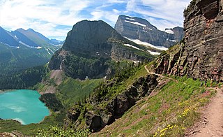
Angel Wing is a 7,430-foot (2,260-meter) elevation mountain summit located in the Lewis Range, of Glacier National Park in the U.S. state of Montana. It is situated one mile east of the Continental Divide, in Glacier County. It can be seen from the Many Glacier area, and up close from the Grinnell Glacier Trail. Topographic relief is significant as the north aspect rises nearly 2,500 feet above Grinnell Lake in one-half mile.

Haystack Butte is a 7,486-foot-elevation (2,282-meter) summit located in the Lewis Range, of Glacier National Park in the U.S. state of Montana. It is situated one mile west of the Continental Divide, in Flathead County, above the Weeping Wall on its south slope. Topographic relief is significant as the west aspect rises 3,900 feet above McDonald Creek in less than 1.5 mile. It can be seen from Logan Pass, and from Going-to-the-Sun Road which traverses the west and south slopes of the peak. The nearest higher neighbor is Mount Gould, 1.07 miles (1.72 km) to the northeast. Climbing access is via the Highline Trail. This geographical feature's descriptive name was on maps as early as 1904, and was officially adopted March 6, 1929, by the United States Board on Geographic Names
Scenic Point is a 7,522-foot-elevation (2,293-meter) mountain summit located in the Two Medicine area of Glacier National Park, in Glacier County, Montana, United States. It is situated in the Lewis Range, six miles northwest of East Glacier Park Village, and approximately seven miles east of the Continental Divide, with precipitation runoff from the mountain draining into the Two Medicine River watershed. Topographic relief is significant as the north aspect rises over 2,600 feet above Lower Two Medicine Lake in one mile. Access to the summit is via the Continental Divide National Scenic Trail which traverses the upper slopes of this mountain. The trail to Scenic Point was constructed by the Great Northern Railway, and the summit once hosted a locomotive bell, a Swiss Alps tradition. The mountain's name was officially adopted in 1929 by the United States Board on Geographic Names.

Citadel Peaks is a mountain ridge located in the Goat Haunt area of Glacier National Park, in Glacier County of the U.S. state of Montana. This arête with a row of sharp points is part of the Livingston Range, and is approximately four miles east of the Continental Divide. Neighbors include Olson Mountain, two miles (3.2 km) to the north, Mount Cleveland four miles (6.4 km) to the east, and Kootenai Peak 2.7 miles (4.3 km) to the south. Topographic relief is significant as Citadel Peaks rises over 3,800 feet above Waterton Lake in less than two miles, and 3,000 feet above Lake Janet in one mile. Precipitation runoff from the mountain drains to the south end of Waterton Lake. The first ascent of Citadel Spire, a major pinnacle on the ridge, was made in 1967 by Jerry Kanzler, Jim Kanzler, Ray Martin, and Clare Pogreba. This geographical feature's name was officially adopted in 1929 by the United States Board on Geographic Names. To the Pikuni people, Citadel Peaks is known as "Ataniawxis", meaning "The Needles".

Gable Peaks is a remote 7,700-foot (2,347-metre) double summit mountain located in Flathead County of the U.S. state of Montana.

Old Baldy is a 9,156-foot (2,791-metre) double summit mountain located in Teton County of the U.S. state of Montana.

Wolf Mountain is an 11,808-foot (3,599-metre) mountain summit located in Park County, Montana.
Sentinel Mountain is an 8,245-foot-elevation (2,513 meter) summit in Glacier County, Montana, United States.

Black Mountain is a 10,941-foot (3,335-metre) summit located in Park County, Montana, United States.

Blaze Mountain is a 10,384-foot (3,165-metre) summit located in Madison County, Montana, United States.

Beehive Peak is a 10,740-foot (3,274-metre) summit located in Madison County, Montana, United States.

Saint Paul Peak is a 7,714-foot-elevation (2,351-meter) mountain summit in Sanders County, Montana.

Rock Peak is a 7,583-foot-elevation (2,311-meter) mountain summit in Sanders County, Montana.

Engle Peak is a 7,583-foot-elevation (2,311-meter) mountain summit in Sanders County, Montana.

Elephant Peak is a 7,938-foot-elevation (2,420-meter) mountain summit located on the border shared by Lincoln and Sanders counties in Montana.

Ibex Peak is a 7,676-foot-elevation (2,340-meter) mountain summit in Sanders County, Montana.
Ojibway Peak is a 7,303-foot-elevation (2,226-meter) mountain summit located on the border shared by Lincoln and Sanders counties in Montana.

A Peak is an 8,634-foot-elevation (2,632-meter) mountain summit located on the border shared by Lincoln and Sanders counties in Montana.


