Cerro Las Tetas

Last updated

Cerro Las Tetas
Las Piedras del Collado
Cerro Las Tetas (in Salinas, PR) as seen from PR-52 NB Rest area at km 49.0 (DSC00798).jpg
Cerro Las Tetas as seen from the PR-52 northbound rest area at km 49.0.
Highest point
Elevation 2,762 ft (842 m) [1]
Prominence 761 ft (232 m)
Coordinates 18°05′36″N66°13′53″W / 18.09333°N 66.23139°W / 18.09333; -66.23139 [1]
Geography
USA Puerto Rico topographic location map.png
Red triangle with thick white border.svg
Cerro Las Tetas
Parent range Sierra de Cayey

Cerro Las Tetas, nicknamed Las Tetas de Cayey but officially Las Piedras del Collado, [2] [3] are two mountain peaks located in the municipality of Salinas, Puerto Rico, [1] north of the city of Salinas proper. Since September 1, 2000, the peaks have become part of the Las Piedras del Collado Nature Reserve and are protected by law. [3] Their height is 2,762 feet (842 m) above sea level. [1]

Contents

Source of the name

The peaks are so named for their resemblance to a woman's breasts. The word "tetas" is colloquial for "breasts" in Spanish, much like the English word "tits". [4]

Location

A common misconception is that Las Tetas are located in the municipality of Cayey. Las Tetas are actually located the municipality of Salinas, in Barrio Palmas, a barrio on the northwestern part of the municipality of Salinas. [5] They are located close to—but not in—the municipality of Cayey, thus the "de Cayey" (English "of Cayey") in its name. They are located about 500 metres (1,600 ft) southwest of the intersection of PR-1 and PR-162. Topological maps readily show this. [5] [6] [7]

Confusion regarding its location

The Las Tetas peaks are part of the "Cayey Mountain Range" (Spanish: Sierra de Cayey). [8] The La Sierra de Cayey mountain range, just like the Cordillera Central and Sierra de Luquillo mountain ranges, extends over several municipalities, not just Cayey. [9] The name of the mountain range where Las Tetas are located (Sierra de Cayey) may be a possible source of confusion regarding the location of the Las Tetas peaks themselves. [10] A little-known fact is that the town of Cayey derives its name from Sierra de Cayey, and not the other way around. [11]

Another possible source of confusion may lie on the fact that the road to reach the Las Tetas peaks starts off from within the municipality of Cayey, albeit just meters from its border with the municipality of Salinas. A third possible source of confusion about the municipality where the mountains are located may be the fact that the peaks are located closer to downtown Cayey than to downtown Salinas. [12] Cayey is also a land-locked and mostly mountainous municipality, whereas Salinas, as a municipality on the southern coastal plain, consists mostly of flatlands. This may be a fourth reason yet why many people believe Las Tetas mountain peaks are located in Cayey, and not in Salinas. Another reason yet for the confusion may be that in order to locate Las Tetas in the official USGS map, the map for the Cayey Quadrangle is used. [7]

In the mid-2000s the town of Salinas took the town of Cayey to court over the location of "Las Tetas" and won the case. The matter involved land development and the Puerto Rico Planning Board. The result was a vindication of the claim that the "Las Tetas" location as being in the municipality of Cayey was incorrect. Las Tetas, the Court agreed, are actually "Las Tetas de Salinas" for they are actually located within the municipality of Salinas, not in Cayey. [13] They have also been called Las Tetas de Salinas. [14] Even so, the name of the mountains are so embedded in Puerto Rican tradition that they continue to be called "Las Tetas de Cayey".

Viewing location

The Las Tetas peaks can be easily viewed from the rest area on Puerto Rico Highway 52, located at kilometer post 49.0 of that highway. The rest area is colocated with the Monumento al Jíbaro Puertorriqueño statue and monument, in the municipality of Salinas. The two peaks can be seen in the northwestern horizon when viewing from the rest area. [15]

Hiking, mountain climbing, and camping at Cerro Las Tetas can be arranged by local tour companies. [16]

Height

The peaks are contoured at 841 metres (2,759 ft) high. However, the western Teta is actually 20 meters higher than its eastern twin. [5]

Views

See also

Related Research Articles

<span class="mw-page-title-main">Cayey, Puerto Rico</span> Town and municipality in Puerto Rico

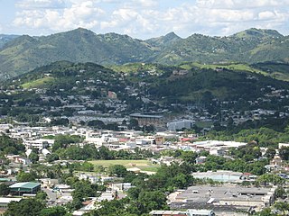
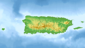
Cayey, officially Cayey de Muesas, is a mountain town and municipality in central Puerto Rico located on the Sierra de Cayey within the Central Mountain range, north of Salinas and Guayama; south of Cidra and Caguas; east of Aibonito and Salinas; and west of San Lorenzo. Cayey is spread over 21 barrios plus Cayey Pueblo. It is part of the San Juan-Caguas-Guaynabo Metropolitan Statistical Area.

<span class="mw-page-title-main">San Lorenzo, Puerto Rico</span> Town and municipality in Puerto Rico

San Lorenzo is a town and municipality of Puerto Rico located in the eastern central region, north of Patillas and Yabucoa; south of Gurabo; east of Caguas and Cayey; and west of Juncos and Las Piedras. San Lorenzo is spread over twelve barrios and San Lorenzo Pueblo. It is part of the San Juan-Caguas-Guaynabo Metropolitan Statistical Area.

<span class="mw-page-title-main">Salinas, Puerto Rico</span> Town and municipality in Puerto Rico

Salinas is a town and municipality in the southern part of Puerto Rico located in the southern coast of the island, south of Aibonito and Cayey; southeast of Coamo, east of Santa Isabel; and west of Guayama. Salinas is spread over 5 barrios and Salinas Pueblo.

<span class="mw-page-title-main">Puerto Rico Highway 52</span> Highway in Puerto Rico

Puerto Rico Highway 52 (PR-52), a major toll road in Puerto Rico, is also known as Autopista Luis A. Ferré. It was formerly called Expreso Las Américas. It runs from PR-1 in southwest Río Piedras and heads south until it intersects with highway PR-2 in Ponce. At its north end, the short PR-18 continues north from PR-52 towards San Juan. This short segment is known as Expreso Las Américas, the only segment of the route still unofficially bearing this name, since PR-18 is officially named Roberto Sánchez Vilella Expressway. The combined route of PR-18 and PR-52 runs concurrent with the unsigned Interstate Highway PRI-1. Toll stations are located in San Juan, Caguas, Salinas, Juana Díaz, and Ponce.

<span class="mw-page-title-main">Cerro de Punta</span> Highest peak in Puerto Rico

Cerro de Punta or just Cerro Punta is the highest peak in Puerto Rico, rising to 1,338 meters (4,390 ft) above sea level. The mountain is part of the Cordillera Central and is located in the municipality of Ponce.

<span class="mw-page-title-main">Cordillera Central (Puerto Rico)</span> Mountain range in Puerto Rico

Cordillera Central, is the main mountain range in Puerto Rico. The range crosses the island from west to east and divides it into its northern and southern coastal plains. The Cordillera Central runs eastward from the municipality of Maricao in the west to Aibonito in the central eastern region, and on to the Caribbean in the southeast through the Sierra de Cayey. The Central Mountain Range consists of the Cordillera Central proper and numerous subranges, foothills and ridges that extend throughout the island. Cerro de Punta is both the highest peak of the Cordillera Central and the highest point in Puerto Rico. The Sierra de Luquillo, where El Yunque is located, is sometimes included as a subrange or eastward extension of the Cordillera Central.

<span class="mw-page-title-main">Monumento al Jíbaro Puertorriqueño</span> Sculpture by Tomás Batista in Salinas, Puerto Rico

The Monumento al Jíbaro Puertorriqueño is a monument built by the Government of Puerto Rico to honor the Puerto Rican Jíbaro, located on Puerto Rico Highway 52, km 49.0, Barrio Lapa, Salinas, Puerto Rico. It was sculpted by Tomás Batista.

<i>Banara vanderbiltii</i> Species of flowering plant

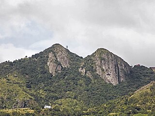
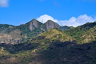
Banara vanderbiltii is a rare species of plant in the willow family known by the common name Palo de Ramón. It is originates from Puerto Rico in the hills of Rio Lajas, and the east peak of "Tetas de Cayey" mountains in Salinas, where there are fewer than 20 known individuals left in the wild. At the time it was listed as an endangered species of the United States in 1987, there were only six plants remaining.

The Ruta Panorámica, officially the Ruta Panorámica Luis Muñoz Marín, is a 167-mile (269 km) network of some 40 secondary roads which traverse the island of Puerto Rico from west to east along its Cordillera Central. Most of the route consists of three roads, PR-105, PR-143, and PR-182. The route starts in Mayagüez and ends in Maunabo. The first major segment of the route runs from Mayagüez to Maricao as Route 105, then from Adjuntas to Aibonito as Route 143, and then follows Route 182 toward Maunabo.

<span class="mw-page-title-main">Breast-shaped hill</span> Hill shaped like a human breast

A breast-shaped hill is a hill in the shape of a breast. Some such hills are named "Pap", an archaic word for the breast or nipple of a woman. Such anthropomorphic geographic features are found in different places of the world and in some cultures they were revered as the attributes of the Mother Goddess, such as the Paps of Anu, named after Anu, an important female deity of pre-Christian Ireland.

<span class="mw-page-title-main">Porta Cordillera</span> Land-locked tourism region in the central mountainous region of Puerto Rico

Porta Cordillera, or simply Central Region, is a land-locked tourism region located in the central mountainous area of Puerto Rico. Porta Cordillera was officially launched in July 2012 by the Puerto Rico Tourism Company. It consists of 16 municipalities: Aguas Buenas, Cidra, Cayey, Comerío, Aibonito, Naranjito, Barranquitas, Corozal, Orocovis, Morovis, Ciales, Jayuya, Florida, Utuado, Adjuntas and Lares.

<span class="mw-page-title-main">Sierra de Cayey</span> Mountain range in Puerto Rico

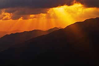
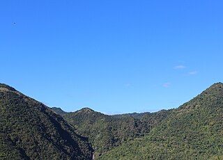
Sierra de Cayey is a mountain range in the main island of Puerto Rico. It is located in the southeast section of the island. Its elevations do not exceed 1000 m.

<span class="mw-page-title-main">Sierra de Jájome</span> Protected area of Puerto Rico

Sierra de Jájome is a mountain massif of the Sierra de Cayey located in the municipalities of Cayey, Guayama and Salinas in southeastern Puerto Rico. The mountain, often referred to as a mountain range (sierra), is protected as the Jájome Protected Natural Area. The Guayama Research Forest Area is also located on the massif. La Robleda, another protected natural area, is located nearby.

<span class="mw-page-title-main">Cerro La Santa</span> Mountain in Puerto Rico

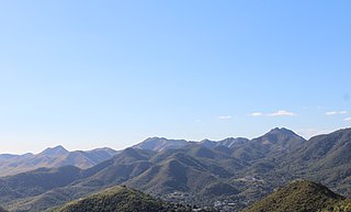
Cerro La Santa is a 2,962 feet high mountain and the highest point in the Sierra de Cayey in Puerto Rico. The peak of Cerro La Santa is located in the Carite State Forest, at a tri-point shared by the municipalities of Caguas, Cayey (Farallón) and San Lorenzo (Espino).

<span class="mw-page-title-main">Cerro Planada</span> Mountain peak in Puerto Rico

Cerro Planada is a mountain peak located in Cayey, Puerto Rico. The mountain has an elevation of 2,480 feet, making it the 10th highest peak of the Sierra de Cayey.

<span class="mw-page-title-main">Planadas-Yeyesa Nature Reserve</span> Protected nature reserve located in Puerto Rico

The Planadas-Yeyesa Nature Reserve is a protected nature reserve located in the Sierra de Cayey, in the municipality of Salinas in central Puerto Rico. The reserve is located close to the famous Cerro Las Tetas. Two of the most prominent features of the reserve are Cerro Planada, a 2,480 feet high mountain peak, and La Yeyesa, a heavily forested canyon formed by the Lapa River and other streams which feed into the Nigua River. La Yeyesa can be accessed through a lightly trafficked yet moderate trail.

<span class="mw-page-title-main">Montes Oscuros</span> Mountain range in Puerto Rico

Montes Oscuros is a small mountain range located between the Sierra de Cayey and the main Cordillera Central, on the municipalities of Coamo and Salinas in southern Puerto Rico. The mountain range and its environment are protected from urban development through a conservation easement, designated as the Montes Oscuros Scenic Easement.

<span class="mw-page-title-main">Cerro Las Piñas</span> Mountain between Caguas and Cayey, Puerto Rico

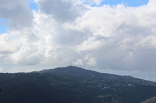
Cerro Las Piñas is a mountain of the Sierra de Cayey located in the boundary between the municipalities of Caguas and Cayey in central Puerto Rico. The summit is located at 2,425 feet above sea level, in the barrios Beatriz of Caguas, and Beatriz and Guavate of Cayey. The summit offers panoramic views of the Valley of Caguas and Cayey.

References

  1. 1 2 3 4 "Las Tetas". Geographic Names Information System . United States Geological Survey, United States Department of the Interior . Retrieved 25 January 2015.
  2. Plan de Uso de Terrenos de Puerto Rico: Perfil Regional - Region Sur. (Borrador Preliminar.) Estado Libre Asociado de Puerto Rico. Junta de Planificacion. Oficina del Plan de Uso de Terrenos. San Juan, Puerto Rico. February 2006. Page 22. Retrieved 2 December 2011.
  3. 1 2 "Salinas, su gente y sus cosas" (in Spanish). Las Piedras del Collado. 18 February 2008. Archived from the original on 24 January 2011. Retrieved 18 November 2010.
  4. Mark, Jason (18 Jan 2018). "Puerto Ricans Still Lack Power Months After Hurricane Maria". Sierra Club . Retrieved 18 Apr 2018.
  5. 1 2 3 "General Purpose Population Data, Census 2000". Maptest. Government of the Commonwealth of Puerto Rico. Archived from the original on 18 February 2010. Retrieved 24 February 2010 via Unidad de Sistemas de Información Geográfica, Área de Tecnología de Información Gubernamental, Oficina de Gerencia y Presupuesto. Gobierno de Puerto Rico.
  6. Patillas Topo Map at Lat 18.1078°N Long -66.0331°W Zoom 15 S Size. Map Styles: Map and Shaded. Trails.com. From: United States Geological Survey. Topo Map. Projection: NAD83/WGS84. Retrieved November 18, 2010.
  7. 1 2 "Salinas County, Puerto Rico, Mountain Peaks & Summits". Mountainzone.com. Archived from the original on 28 September 2012. Retrieved November 18, 2010.
  8. "Salinas". Puerto Rico Encyclopedia. Archived from the original on 22 November 2010. Retrieved 18 November 2010.
  9. "Geography of Puerto Rico". Sol Boricua. Archived from the original on 10 December 2010. Retrieved 18 November 2010.
  10. Puerto Rico Geological Formations Map. U.S. Geological Survey. Accessed November 18, 2010.
  11. Cayey...Ciudad de las Brumas. Accessed November 18, 2010.
  12. Hombres Ilustres. Archived 2016-03-04 at the Wayback Machine Manual de Informacion sobre Cayey: La mejor ciudad de Las Americas. Government of Puerto Rico. p.9. Undated. Retrieved 26 February 2014.
  13. Aibonito pide teta izquierda. Archived 2011-07-15 at the Wayback Machine Primera Hora. Alex David. May 7, 2005.
  14. Lo importante no es de quién son la Tetas, sino qué hacer con ellas. Archived 2011-07-15 at the Wayback Machine Alex David. Primera Hora. 10 May 2005.
  15. "Las 'Tetas' son del Gobierno: Las emblemáticas montañas fueron adquiridos ayer por el DRNA". El Nuevo Dia. 20 February 2009. Archived from the original on 18 September 2012. Retrieved 18 November 2010.
  16. "Las Piedras del Collado (Cerro Las Tetas)". Discover Puerto Rico. Retrieved 23 June 2020.