Related Research Articles

Taney County is a county in the southwestern portion of the U.S. state of Missouri. As of the 2020 census, the population was 56,066. Its county seat is Forsyth. It is included in the Micropolitan Statistical Area.

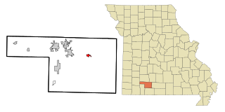
Christian County is located in the southwestern part of the U.S. state of Missouri. As of the 2020 census, its population was 88,842. Its county seat is Ozark. The county was organized in 1859 and is named after Christian County, Kentucky, which in turn is named for William Christian, a Kentucky soldier of the American Revolutionary War.

Benton County is a county in the Northwest region of the U.S. state of Arkansas. Created as Arkansas' 35th county on September 30, 1836, Benton County contains thirteen incorporated municipalities, including Bentonville, the county seat, and Rogers, the most populous city. The county was named after Thomas Hart Benton, a U.S. Senator from Missouri influential in Arkansas statehood.
Sparta is a city in north central Christian County, Missouri, United States. The population was 1,756 at the 2010 census.

Springfield is the third most populous city in the U.S. state of Missouri and the county seat of Greene County. The city's population was 169,176 at the 2020 census. It is the principal city of the Springfield metropolitan area, which had an estimated population of 487,061 in 2022 and includes the counties of Christian, Dallas, Greene, Polk, and Webster, The city sits on the Springfield Plateau of the Ozarks, which ranges from nearly-level to rolling hills. Springfield is the second-largest urban area in the Ozarks.

The Ozarks, also known as the Ozark Mountains, Ozark Highlands or Ozark Plateau, is a physiographic region in the U.S. states of Missouri, Arkansas, Oklahoma and the extreme southeastern corner of Kansas. The Ozarks cover a significant portion of northern Arkansas and most of the southern half of Missouri, extending from Interstate 40 in central Arkansas to Interstate 70 in central Missouri.

The St. Louis–San Francisco Railway, commonly known as the "Frisco", was a railroad that operated in the Midwest and South Central United States from 1876 to November 21, 1980. At the end of 1970, it operated 4,547 miles (7,318 km) of road on 6,574 miles (10,580 km) of track, not including subsidiaries Quanah, Acme and Pacific Railway and the Alabama, Tennessee and Northern Railroad; that year, it reported 12,795 million ton-miles of revenue freight and no passengers. In 1980 it was purchased by and absorbed into the Burlington Northern Railroad. Despite its name, it never came close to San Francisco.

Mark Twain National Forest (MTNF) is a U.S. National Forest located in the southern half of Missouri, composed of nine disconnected parcels. MTNF was established on September 11, 1939. It is named for author Mark Twain, a Missouri native. The MTNF covers 3,068,800 acres (12,419 km2) of which 1,506,100 acres (6,095 km2) is public owned, 78,000 acres (320 km2) of which are Wilderness, and National Scenic River area. MTNF spans 29 counties and represents 11% of all forested land in Missouri. MTNF's nine tracts are divided into six distinct ranger districts: Ava-Cassville-Willow Springs, Eleven Point, Houston-Rolla, Cedar Creek, Poplar Bluff, Potosi-Fredericktown, and the Salem. Its headquarters are in Rolla, Missouri.
Oldfield is an unincorporated community in Christian County, Missouri, United States. It is located 2.6 miles (4.2 km) southeast of Sparta at the intersection of Route 125 and Route T. Chadwick lies 3.2 miles (5.1 km) to the southeast on Route 125. The elevation is 1,381 feet. The community is part of the Springfield, Missouri Metropolitan Statistical Area.
Chestnutridge is an unincorporated community in southwestern Christian County, Missouri, United States and is located approximately fourteen miles south of Ozark and about 3.5 miles southeast of Spokane. The community is located on Chestnut Ridge, at an elevation of 1325 feet. It is on Missouri Route BB just east of Missouri Route 176 and about two miles west of U.S. Route 65.
The Old Wire Road is a historic road in Missouri and Arkansas. Several local roads are still known by this name. It followed an old Native American route, the Great Osage Trail across the Ozarks and became a road along a telegraph line from St. Louis, Missouri, to Fort Smith, Arkansas. This route was also used by the Butterfield Overland Mail. It was known simply as the "Wire Road" while the telegraph line was up, but when the line was later removed, it became known as the "Old Wire Road". In St. Louis, where the road begins at Jefferson Barracks, it is called Telegraph Road. From St. Louis to Springfield, Missouri, it became designated Route 14 which, in turn, later became U.S. Route 66 and still later Interstate 44.

The Springfield, Missouri, metropolitan area, as defined by the United States Census Bureau, is an area consisting of five counties in southwestern Missouri, anchored by the city of Springfield, the state's third largest city. Other primary population centers in the metro area include Nixa, Ozark, Republic, Bolivar, Marshfield and Willard. Currently, the city limits of Springfield reach the Nixa, and Ozark city limits at the Christian County line on US 160, and US 65 respectively, the city limits of Republic at James River Freeway on the southwest side of the city, and the Strafford city limits on Route 744 on the northeast side of the city.

Linden is an unincorporated community in northern Christian County, Missouri United States. It is located approximately 4.5 miles northwest of Sparta on Route 125, where the highway crosses the Finley Creek. The river has been dammed, creating a small lake, Lake Lindenlure, just east of Route 125.
Elk Valley is a valley in Christian County in the Ozarks of southwest Missouri.
Lawing is an extinct town in Christian County, in the U.S. state of Missouri. The community was located on Logan Ridge along the south edge of the Springfield Plateau. Missouri Route W passes through the location and Christian Center is about one mile to the north. The city of Ozark is approximately seven miles to the north-northwest.
McCracken is an unincorporated community in Christian County, in the U.S. state of Missouri. It is about 3.3 miles east of Ozark, Missouri.
Karlin is an unincorporated community in central Polk County, in the Ozarks of southwest Missouri, United States.
Bull Creek is a stream in Christian and Taney counties in the Ozarks of southern Missouri.
Swan Creek is a stream in the Ozarks of southern Missouri. It is a tributary of the White River downstream from the Lake Taneycomo dam.
Christian Center is an unincorporated community in Christian County in the Ozarks of southwest Missouri, United States.
References
- ↑ U.S. Geological Survey Geographic Names Information System: Chadwick, Missouri
- ↑ "Chadwick township, Christian County, Missouri". United States Census Bureau. Retrieved August 22, 2024.
- 1 2 Chadwick, MO, 7.5 Minute Topographic Quadrangle, USGS, 2004
- ↑ "Post Offices". Jim Forte Postal History. Archived from the original on March 6, 2016. Retrieved September 18, 2016.
- ↑ "Christian County Place Names, 1928–1945 (archived)". The State Historical Society of Missouri. Archived from the original on June 24, 2016. Retrieved September 18, 2016.
{{cite web}}: CS1 maint: bot: original URL status unknown (link) - ↑ Eaton, David Wolfe (1916). How Missouri Counties, Towns and Streams Were Named. The State Historical Society of Missouri. p. 275.
- ↑ "Pokin Around: Plans call for part of Chadwick Flyer spur line to become recreational trail". Steve Pokin, Springfield News-Leader, April 4, 2020.
- ↑ "An Early Mobile Photographic Studio" (PDF). All Aboard, The Frisco Railroad Museum, August, 1988 (accessed on CondrenRails.com). Retrieved October 14, 2020.
- ↑ "Chadwick Motorcycle and ATV Use Area". United States Department of Agriculture, Forest Service. Retrieved October 15, 2020.
36°55′48″N93°03′25″W / 36.93000°N 93.05694°W
Municipalities and communities of Christian County, Missouri, United States | ||
|---|---|---|
| Cities |  | |
| Village | ||
| Townships | ||
| CDP | ||
| Unincorporated communities | ||
| Ghost towns | ||
| Footnotes | ‡This populated place also has portions in an adjacent county or counties | |
| | This Christian County, Missouri state location article is a stub. You can help Wikipedia by expanding it. |