
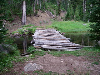
The Sawtooth National Recreation Area (SNRA) is a national recreation area in central Idaho, United States that is managed as part of Sawtooth National Forest. The recreation area, established on August 22, 1972, is managed by the U.S. Forest Service, and includes the Sawtooth, Hemingway–Boulders, and Cecil D. Andrus–White Clouds wilderness areas. Activities within the 730,864-acre (2,957.70 km2) recreation area include hiking, backpacking, White water rafting, camping, rock climbing, kayaking, mountain biking, fishing, and hunting.

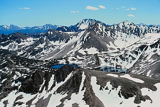
The White Cloud Mountains are part of the Rocky Mountains of the western United States, located in central Idaho, southeast of Stanley in Custer County. The range is located within the Sawtooth National Recreation Area (SNRA) and partially within the Cecil D. Andrus–White Clouds Wilderness.

Castle Peak is a mountain in the western United States, the highest peak in the White Cloud Mountains of central Idaho and the Idaho Batholith. Located in Custer County, it is the 25th highest peak in the state, and the ninth most prominent.
Baker Lake is an alpine lake in Custer County, Idaho, United States, located in the White Cloud Mountains in the Sawtooth National Recreation Area. The name is derived from the fact that the lake is adjacent to mining claims held by the Baker family for many years.
Bear Lake is an alpine lake in Custer County, Idaho, United States, located in the White Cloud Mountains in the Sawtooth National Recreation Area. The lake is accessed from Sawtooth National Forest trail 671 along Warm Springs Creek.
Boulder Lake is an alpine lake in Custer County, Idaho, United States, located in the White Cloud Mountains in the Sawtooth National Recreation Area. The lake is in the Big Boulder Lakes Basin, and is accessed from Sawtooth National Forest trails 601 and 680.
Cornice Lake is an alpine lake in Custer County, Idaho, United States, located in the White Cloud Mountains in the Sawtooth National Recreation Area. The lake is in the Four Lakes Basin and is most easily accessed from Sawtooth National Forest trail 683.
Sapphire Lake is an alpine lake in Custer County, Idaho, United States, located in the White Cloud Mountains in the Sawtooth National Recreation Area. No trails lead to the lake, but it can be most easily accessed from Sawtooth National Forest trail 601.

Shelf Lake is an alpine lake in Custer County, Idaho, United States, located in the White Cloud Mountains in the Sawtooth National Recreation Area. The lake is named for a distinct rock shelf extending around the south and west shores of the lake.
Lonesome Lake is an alpine lake in Custer County, Idaho, United States, located in the White Cloud Mountains in the Sawtooth National Recreation Area. The lake is accessed from Sawtooth National Forest trail 683.
The Big Boulder Lakes are a chain of thirteen small alpine and glacial Paternoster lakes in Custer County, Idaho, United States, located in the White Cloud Mountains in the Sawtooth National Recreation Area. The lakes are located in the upper portion of the Big Boulder Creek watershed east of D. O. Lee Peak. In addition to the lakes listed, the Big Boulder Lakes include the four small lakes that make up The Kettles. Sawtooth National Forest trail 601 along leads to the Big Boulder Lakes.
The Kettles are a chain of four small alpine glacial lakes in Custer County, Idaho, United States, located in the White Cloud Mountains in the Sawtooth National Recreation Area. The lakes are located in the upper portion of the Big Boulder Creek watershed east of D. O. Lee Peak in the uppermost portion of the Big Boulder Lakes Basin. Sawtooth National Forest trail 601 along leads to the Big Boulder Lakes.

The Four Lakes are a chain of four small glacial Paternoster lakes in Custer County, Idaho, United States, located in the White Cloud Mountains in the Sawtooth National Recreation Area. The lakes are located in the upper portion of the Little Boulder Creek watershed upstream of Quiet Lake and east of Patterson Peak. No trails lead to the Four Lakes Basin.
The Six Lakes are a chain of six alpine and glacial Paternoster lakes in Custer County, Idaho, United States, located in the White Cloud Mountains in the Sawtooth National Recreation Area. The lakes are located on the upper portion of the Fourth of July Creek watershed, a tributary of the Salmon River and the outflow of Fourth of July Lake. The Six Lakes are above Heart Lake. The lakes have not been individually named, and the three uppermost lakes are at nearly the same elevation and may form one lake when water levels are high. While no trails lead to the lakes, they are most easily accessed from Sawtooth National Forest road 205 along Fourth of July Creek. The lakes do not have official names and are listed from lowest to highest elevation.

The Born Lakes are a chain of eleven alpine and glacial Paternoster lakes in Custer County, Idaho, United States, located in the White Cloud Mountains in the Sawtooth National Recreation Area. The lakes are located on the upper portion of the Warm Springs Creek watershed, a tributary of the Salmon River. The Born Lakes surrounded by Patterson, Blackmon, and Lonesome Lake Peaks. Sawtooth National Forest trail 671 leads to the lakes. The individual lakes do have official names, and many of them have partially or nearly completely filled in with sediment.
The Champion Lakes are a chain of seven alpine and glacial Paternoster lakes in Custer County, Idaho, United States, located in the White Cloud Mountains in the Sawtooth National Recreation Area. The lakes are located on the upper portion of the Champion Creek watershed, a tributary of the Salmon River. The lakes have not been individually named, and lakes 5 and 6 are often dry. Sawtooth National Forest trail 105 leads to the lakes. In 2005 the Valley Road Forest Fire burned part of the Champion Lakes Basin.
The Garland Lakes are a chain of eight small alpine glacial lakes and several former lakes in Custer County, Idaho, United States, located in the White Cloud Mountains in the Sawtooth National Recreation Area. The lakes are located on the upper portion of the Big Casino Creek watershed, a tributary of the Salmon River. The lakes have not been individually named, and Sawtooth National Forest trails 646 and 616 lead to the lakes. The Garland Lakes are south of Rough Lake and east of the Casino Lakes.

Merriam Peak, at 10,920 feet (3,330 m) is one of the peaks of the White Cloud Mountains of Custer County, Idaho. It was named for John H. Merriam who played an instrumental role in protecting the area from being mined for molybdenum. Merriam Peak is located in the middle of the range just north of Castle Peak, the highest point in the range. The peak is located in the White Clouds roadless area of Sawtooth National Recreation Area.

D. O. Lee Peak, also known as Lee Peak, at 11,347 feet (3,459 m) above sea level, is the third-highest peak in the White Cloud Mountains of the U.S. state of Idaho. It is one of the White Cloud Peaks and the 56th-highest peak in Idaho. It was named after Challis native David Oliver Lee (1934–1982), the first United States Forest Service ranger to be assigned to the Sawtooth Wilderness.

Blackmon Peak, also known as Blackman Peak, at 10,302 feet (3,140 m) above sea level is a peak in the White Cloud Mountains of Idaho. The peak is located in Sawtooth National Recreation Area in Custer County 2.11 mi (3.40 km) from Castle Peak, its line parent. It is named for George Blackmon (b.1854), freed slave and mining pioneer.


