Chasqui I

Last updated
Chasqui I
Chasqui1.jpg
Chasqui I
Mission typeScientific
Operator National University of Engineering
COSPAR ID 1998-067ET OOjs UI icon edit-ltr-progressive.svg
SATCAT no. 40117 OOjs UI icon edit-ltr-progressive.svg
Website www.chasqui.uni.edu.pe
Spacecraft properties
Bus 1U CubeSat
Launch mass1 kilogram (2.2 lb)
Start of mission
Launch dateAugust 18, 2014 (2014-08-18)
Orbital parameters
Reference system Geocentric
Regime Low Earth
 

Chasqui I is a one-kilogram nanosatellite developed by students at Peru's National University of Engineering (UNI) based on CubeSat technology. Developed with assistance from the Russian Southwest State University (SWSU), Kursk, it was part of an educational project to acquire the experience and ability in developing satellites.

Contents

The nanosatellite was launched from the International Space Station during a spacewalk on August 18, 2014. [1] The concept satellite was equipped with two cameras—one for visible light and one for infrared—to take photos of Earth.

The name of the project refers to the chasqui , who served as messengers in the Inca Empire.

General objectives

Most of UNI's objectives in satellite technology were completed through the CubeSat nanosatellites. Plans for Chasqui I included taking pictures of the Earth, with transmission to a ground station.

Specific objectives of the project were to (1) establish contact and support other universities and institutions involved in such projects; (2) deepen the knowledge in emerging information and communications technologies; (3) lead projects within Latin America; and (4) demonstrate and validate new technologies.[ citation needed ]

The stated goals of the project were:[ citation needed ]

Project

Logo chasqui1.jpg
Chasqui I in space
Logo chasqui 1.png
Chasqui I logo

Chasqui I is a student research project nanosatellite, weighing less than 1 kg and having a volume of up to 1 Lt. It was designed to image Peruvian land using a CMOS camera that seeks to distinguish between fertile land and uncultivated areas. As a student project, Chasqui I was constructed using commercial components. It uses amateur radio frequency, making it possible to be located throughout the country. The Chasqui I students also developed a ground station that allows for remote monitoring of the satellite, as well as satellites of other universities.

Peru has large geographical diversity, which makes it very difficult to constantly monitor the situation of natural and man-made events, such as permanent snow melting, deforestation of the Amazon, the protection of habitats of endangered species, combating narco-terrorism, surveillance of borders and territorial sea, and the prediction and mitigation of natural disasters. UNI, with its project Chasqui I, are taking steps in the process of addressing problems such as crop monitoring and telecommunications areas.
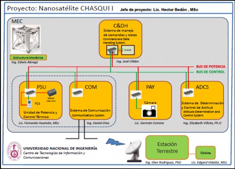
Project modules

Outline of the project development modules Nano02.jpg
Outline of the project development modules

Mechanical Structure – EMEC

Simulation of displacements in the satellite's internal frame Emec desplazamientos.png
Simulation of displacements in the satellite's internal frame

The mechanical structure (EMEC) module was responsible for reviewing the state of field, comparing existing nanosatellite designs, and manufacturing the satellite based on the standard CubeSat format.

Central Control and Information Management – CCIM

This subsystem manages and monitors information from all subsystems of Chasqui I. It contains a processor called the on-board computer (OBC), which fulfills the computing functions of all other subsystems.

Power and Thermal Control – PCT

Energy cycle of Chasqui I Pct 01.png
Energy cycle of Chasqui I

The Power subsystem is responsible for receiving, processing, storing, and distributing power to other subsystems in the satellite. The objective of this subsystem is to ensure the necessary supply of electricity.

The Thermal Control subsystem is responsible for maintaining the proper temperature of the satellite components. The most critical task of this subsystem is to maintain the batteries within their operating limits of 0 °C–20 °C.

These subsystems also manage and monitor the state of the satellite, such as temperature, voltage and current. Both subsystems, including the heaters, were designed and built at UNI.[ citation needed ]

Communication System – SICOM

This subsystem is responsible for providing a means of communication between the satellite and the ground station.[ citation needed ]

Image Acquisition System – SIMA

Block diagram of SIMA Sima 01.png
Block diagram of SIMA

This subsystem obtains photographs of the Earth using two cameras: one in the visible and the other in the near-infrared. Digital information is collected by the CCIM and then sent to the ground station (ESTER). Additionally, the module is responsible for processing digital images obtained.

System Identification and Attitude Control – SDCA

Block diagram of SDCA Mod sdca 01.jpg
Block diagram of SDCA

This subsystem maintains the nanosatellite's stabilization and orientation, adjusting the orientation when necessary. Specifically, the module[ citation needed ]

The SDCA enables Chasqui I to determine its attitude, calculate the correction required to achieve the desired orientation, and execute the necessary maneuvers using the actuators. The attitude determination system uses magnetometers, Sun sensors, and attitude determination algorithms for estimating positions and angular velocities. Using GPS and gyroscopes as sensors for determining attitude was also evaluated.[ citation needed ] The attitude control system uses electromagnetic coils and permanent magnets as actuators, forming what are known as magnetorquers. The magnetorquers are especially important for the stabilization of the nanosatellite once it leaves the deployer. The inclusion of the permanent magnet creates a system of active-passive control. The use of magnetic materials and magnetic hysteresis were also evaluated.[ citation needed ]

Ground Station – ESTER

Block diagram of ESTER Mod ester 01.jpg
Block diagram of ESTER

This ground-based subsystem consists of the facilities and wireless communication (radio) needed to communicate with the Chasqui I (and any other satellite). Its main functions are:[ citation needed ]

System Orbits – SORS

Trajectory of Chasqui I Sors 04.png
Trajectory of Chasqui I

This module aims to simulate the trajectory of Chasqui I, which is calculated solving differential equations of motion in parallel using two programs: DelPhi and MATLAB.

This simulation is accomplished by taking into consideration the following phases:[ citation needed ]

Module Integration and Testing – MIP

MIP rendering of the subsystems of Chasqui I Mip 01.png
MIP rendering of the subsystems of Chasqui I

This module was responsible for the assembly of all the satellite components such as circuit boards, cameras, batteries, antennas, sensors, and magnetorquers. Subsequent goals included optimizing surfaces, volumes, masses; finding the center of mass; planning and conducting standardized testing requirements; and performing field tests.

See also

Related Research Articles

<span class="mw-page-title-main">CubeSat</span> Miniature satellite in 10 cm cube modules

A CubeSat is a class of miniaturized satellite with a form factor of 10 cm (3.9 in) cubes. CubeSats have a mass of no more than 2 kg (4.4 lb) per unit, and often use commercial off-the-shelf (COTS) components for their electronics and structure. CubeSats are put into orbit by deployers on the International Space Station, or launched as secondary payloads on a launch vehicle. As of August 2021, more than 1,600 CubeSats have been launched.

The Space Test Program (STP) is the primary provider of spaceflight for the United States Department of Defense (DoD) space science and technology community. STP is managed by a group within the Advanced Systems and Development Directorate, a directorate of the Space and Missile Systems Center of the United States Space Force. STP provides spaceflight via the International Space Station (ISS), piggybacks, secondary payloads and dedicated launch services.

The Canadian Advanced Nanospace eXperiment (CanX) program is a Canadian CubeSat nanosatellite program operated by the University of Toronto Institute for Aerospace Studies, Space Flight Laboratory (UTIAS/SFL). The program's objectives are to involve graduate students in the process of spaceflight development, and to provide low-cost access to space for scientific research and the testing of nanoscale devices. The CanX projects include CanX-1, CanX-2, the BRIght Target Explorer (BRITE), and CanX-4&5.

The Cornell University Satellite (CUSat) is a nanosatellite developed by Cornell University that launched on 29 September 2013. It used a new algorithm called Carrier-phase Differential GPS (CDGPS) to calibrate global positioning systems to an accuracy of 3 millimeters. This technology can allow multiple spacecraft to travel in close proximity.

ITUpSAT1, short for Istanbul Technical University picoSatellite-1, is a single CubeSat built by the Faculty of Aeronautics and Astronautics at the Istanbul Technical University. It was launched on 23 September 2009 atop a PSLV-C14 satellite launch vehicle from Satish Dhawan Space Centre, Sriharikota, Andhra Pradesh in India, and became the first Turkish university satellite to orbit the Earth. It was expected to have a minimum of six-month life term, but it is still functioning for over two years. It is a picosatellite with side lengths of 10 centimetres (3.9 in) and a mass of 0.990 kilograms (2.18 lb).

A magnetorquer or magnetic torquer is a satellite system for attitude control, detumbling, and stabilization built from electromagnetic coils. The magnetorquer creates a magnetic dipole that interfaces with an ambient magnetic field, usually Earth's, so that the counter-forces produced provide useful torque.

<span class="mw-page-title-main">Radio Aurora Explorer</span>

Radio Aurora Explorer (RAX) is the first National Science Foundation sponsored CubeSat mission. The RAX mission is a joint effort between SRI International in Menlo Park, California and the University of Michigan in Ann Arbor, Michigan. The chief scientist at SRI International, Dr. Hasan Bahcivan, led his team at SRI to develop the payload while the chief engineer, Dr. James Cutler, led a team of students to develop the satellite bus in the Michigan Exploration Laboratory. There are currently two satellites in the RAX mission.

Jugnu, is an Indian technology demonstration and remote sensing CubeSat satellite which was operated by the Indian Institute of Technology Kanpur. Built under the guidance of Dr. N. S. Vyas, it is a nanosatellite which will be used to provide data for agriculture and disaster monitoring. It is a 3-kilogram (6.6 lb) spacecraft, which measures 34 centimetres (13 in) in length by 10 centimetres (3.9 in) in height and width. Its development programme cost around 25 million rupee. It has a design life of one year.

<span class="mw-page-title-main">SARAL</span> Indian Earth observation satellite

SARAL is a cooperative altimetry technology mission of Indian Space Research Organisation (ISRO) and Centre National d'Études Spatiales (CNES). SARAL performs altimetric measurements designed to study ocean circulation and sea surface elevation.

StudSat-2 is a nanosatellite under development with Studsat-2 Consortium and Visvesvaraya Technological University (VTU) for proving the concept of Inter-satellite link (ISL). The Twin-Satellites STUDSAT-2A and STUDSAT-2B weighing less than 10 kg (22 lb) are of dimensions 30×30×15 cm. The main goal of the StudSat-2 project is to develop a low-cost small satellite, capable of operating small scientific or technological payloads where real time connectivity is provided by inter-satellite links.

<span class="mw-page-title-main">LituanicaSAT-1</span>

LituanicaSAT-1 was one of the first two Lithuanian satellites. It was launched along with the second Cygnus spacecraft and 28 Flock-1 CubeSats aboard an Antares 120 carrier rocket flying from Pad 0B at the Mid-Atlantic Regional Spaceport on Wallops Island to the International Space Station. The launch was scheduled to occur in December 2013, but later was rescheduled to 9 January 2014 and occurred then. The satellite was broadcasting greetings of Lithuanian president, Mrs. Dalia Grybauskaitė. The satellite was deployed from the International Space Station via the NanoRacks CubeSat Deployer on February 28, 2014. All LituanicaSAT-1 subsystems have been turned on, tested and proved to be working properly. The mission is considered a complete success by its team of engineers. The mission ended upon the reentry and disintegration of the satellite on July 28, 2014.

<span class="mw-page-title-main">EQUiSat</span>

EQUiSat was a 1U CubeSat designed and built by Brown Space Engineering, an undergraduate student group at Brown University's School of Engineering. EQUiSat's mission was to test a battery technology that had never flown in space which powered an beacon that was designed to be visible from Earth.

<span class="mw-page-title-main">Nanoracks CubeSat Deployer</span> Device to deploy CubeSats into orbit from the International Space Station

The Nanoracks CubeSat Deployer (NRCSD) is a device to deploy CubeSats into orbit from the International Space Station (ISS).

<span class="mw-page-title-main">Swayam</span>

Swayam is a 1-U picosatellite (CubeSat) developed by the undergraduate students of College of Engineering, Pune. They have successfully completed assembly of the flight model having a size of 1-U and weight of 990 grams under the guidance of Indian Space Research Organisation (ISRO) in January 2015. The structural design of the satellite, design of its electronic and control systems as well as the manufacturing of the satellite was carried out by the students. The project was completed over a span of 8 years and more than 200 students worked on it. The Satellite was launched by ISRO on June 22, 2016, along with Cartosat-2C by Polar Satellite Launch Vehicle C-34 from the second launch pad at Satish Dhawan Space Center, Sriharikota, India. The satellite is to be placed in low Earth orbit (LEO) around Earth at a height of 515 km.

CubeSail is a proposed nanosatellite project by the Surrey Space Centre (SSC) in England. The spacecraft is to be a 3U CubeSat propelled by a 25 m²solar sail. The project is financed and technically supported by aerospace manufacturers Astrium and Surrey Satellite Technology.

<span class="mw-page-title-main">ASTERIA (spacecraft)</span> CubeSat testing technologies for the detection of exoplanets

ASTERIA was a miniaturized space telescope technology demonstration and opportunistic science mission to conduct astrophysical measurements using a CubeSat. It was designed in collaboration between the Massachusetts Institute of Technology (MIT) and NASA's Jet Propulsion Laboratory. ASTERIA was the first JPL-built CubeSat to have been successfully operated in space. Originally envisioned as a project for training early career scientists and engineers, ASTERIA's technical goal was to achieve arcsecond-level line-of-sight pointing error and highly stable focal plane temperature control. These technologies are important for precision photometry, i.e., the measurement of stellar brightness over time. Precision photometry, in turn, provides a way to study stellar activity, transiting exoplanets, and other astrophysical phenomena.

<span class="mw-page-title-main">Maya-1</span> First nanosatellite filipino spacecraft

Maya-1 was a Filipino nanosatellite. It was developed under the Philippine Scientific Earth Observation Microsatellite program (PHL-Microsat) and was jointly implemented by the University of the Philippines and the Department of Science and Technology as part of the Kyushu Institute of Technology-led multinational second Joint Global Multi-nations Birds Satellite (Birds-2). Maya-1 was the first nanosatellite of the Philippines.

<span class="mw-page-title-main">Nanosat 01</span>

The Nanosat 01, sometimes written as NanoSat-1 or NanoSat 01, was an artificial satellite developed by the Spanish Instituto Nacional de Técnica Aeroespacial (INTA) and launched the 18th of December 2004. Considered a nano satellite for its weight of less than 20 kg, its main mission was forwarding communications between far reaching points of the Earth such as Juan Carlos I Antarctic Base from mainland Spain. This was possible due to its polar orbit and altitude of 650 km above sea level. During an operational run the data obtained in the Antarctic would be uploaded to the satellite during its fly by and then, downloaded in Spain when satellite reached the Iberian Peninsula.

<span class="mw-page-title-main">OPTOS</span> Spanish nanosatellite

OPTOS was a Spanish nanosatellite designed and developed by INTA with support from the European Cooperation for Space Standardization (ECSS) as a low-cost technology demonstrator. It was launched in 2013 and had a service life of three years.

The Lume-1 is a Spanish nanosatellite developed for educational and scientific purposes by the University of Vigo in cooperation with Alén Space, the University of Porto and the French National Centre of Scientific Research. The satellite is part of the Fire-RS program in order to battle wildfires.

References

  1. "Photos: Cosmonauts Take Spacewalk to Launch Peruvian Satellite". Space.com . 18 August 2014.