Chepachet, Rhode Island

Last updated

Chepachet Village Historic District
Chepachet, Rhode Island (ca 1905).jpg
Chepachet depicted in a 1905 postcard
USA Rhode Island location map.svg
Red pog.svg
Usa edcp location map.svg
Red pog.svg
Location Glocester, Rhode Island
Built1799
NRHP reference No. 71000031 [1]
Added to NRHPMarch 31, 1971
Location of the CDP in Providence County and the state of Rhode Island Providence County Rhode Island incorporated and unincorporated areas Chepachet highlighted.svg
Location of the CDP in Providence County and the state of Rhode Island

Chepachet is a village and census-designated place (CDP) [2] in the town of Glocester in the northwestern part of the U.S. state of Rhode Island. It is centered at the intersection of U.S. Route 44 (a.k.a. Putnam Pike) and Rhode Island Route 102 (also known as Victory Highway and Chopmist Hill Road). Chepachet's ZIP code is 02814. As of the 2010 census, the CDP had a population of 1,675. [3]

Contents

History

"Chepachet" was originally inhabited by the Pequot and Nipmuc natives; the name means "where rivers meet".

Leading up to the American Revolution, the area was a hotbed for supporters of independence, and the Gloucester Light Infantry was founded in the Chepachet in 1774. During the Revolutionary War Loyalists from Newport were exiled near Chepachet, including Thomas Vernon, who recorded election celebrations in Chepachet in 1776:

This being the day for the choice of Deputies (members of the General Assembly). We are told that there is a very great resort of people of all kinds at Chepasseh, and that it is a day of great frolicking. Our landlord and his three sons are gone, having rigged themselves out in the best manner. [A] man on horseback passed by (together with many others) with a very large bag full of cakes made by Granne West (mother to the General William West) which are to be sold to the people. [4]

In 1842, Chepachet was the setting of the endgame of the Dorr Rebellion, which helped to win voting rights for non-landowners in a new state Constitution.

On November 4, 1923, horror writer H. P. Lovecraft and his fellow writer C. M. Eddy, Jr. ventured to Chepachet in search of a place known as "Dark Swamp" of which they had heard rumors. They never located it, but the region inspired at least the opening of Lovecraft's story (novelette) "The Colour Out of Space", and the setting contributed to Eddy's unfinished story "Black Noon". Chepachet is also mentioned several times in Lovecraft's story (novelette) "The Horror at Red Hook".

Since 1926, the town has hosted the Ancients and Horribles parade, an annual Fourth of July event, notable for its political statements and ribald humor.

In the 1940s, a US Navy auxiliary ship, the fleet fuel oil tanker, USS Chepachet, was named after the Chepachet River which runs through the village. The ship's bell is displayed at the seat of town government, and the ship's surviving crew had a 50th anniversary reunion in the town in 1998.

Beginning with a proclamation in 1976, May 25 is recognized as "Elephant Day". On that date in 1826, a popular elephant known as Betty the Learned Elephant from a traveling show was shot and killed while she was crossing the bridge spanning the Chepachet River. [5] A group of six "hooligans" led by Canton Smith of nearby North Scituate faced charges for the crime. [6] A commemorative plaque marks the historic location on the bridge.

Demographics

2020 census

The 2020 United States census counted 1,704 people, 744 households, and 405 families in Chepachet. The population density was 309.4 per square mile (119.4/km2). There were 778 housing units at an average density of 141.2 per square mile (54.5/km2). [7] [8] The racial makeup was 93.19% (1,588) white or European American (92.49% non-Hispanic white), 0.59% (10) black or African-American, 0.12% (2) Native American or Alaska Native, 0.35% (6) Asian, 0.0% (0) Pacific Islander or Native Hawaiian, 0.53% (9) from other races, and 5.22% (89) from two or more races. [9] Hispanic or Latino of any race was 1.88% (32) of the population. [10]

Of the 744 households, 25.1% had children under the age of 18; 46.9% were married couples living together; 25.5% had a female householder with no spouse or partner present. 31.5% of households consisted of individuals and 17.7% had someone living alone who was 65 years of age or older. [7] The average household size was 2.6 and the average family size was 3.2. [11] The percent of those with a bachelor’s degree or higher was estimated to be 22.2% of the population. [12]

17.3% of the population was under the age of 18, 6.2% from 18 to 24, 23.5% from 25 to 44, 30.0% from 45 to 64, and 22.9% who were 65 years of age or older. The median age was 47.8 years. For every 100 females, the population had 110.4 males. [7] For every 100 females ages 18 and older, there were 111.1 males. [7]

The 2016-2020 5-year American Community Survey estimates show that the median household income was $80,759 (with a margin of error of +/- $16,981) and the median family income was $67,465 (+/- $28,988). Males had a median income of $56,250 (+/- $16,409) versus $36,989 (+/- $10,754) for females. [13] The median income for those above 16 years old was $50,417 (+/- $17,529). [14] Approximately, 7.4% of families and 10.3% of the population were below the poverty line, including 17.0% of those under the age of 18 and 24.0% of those ages 65 or over. [15] [16]

Schools

The area, part of the town of Glocester, is part of the Foster-Glocester Regional School District, meaning Ponaganset High School is the only secondary school for residents of Chepachet. West Glocester Elementary, an elementary school in Chepachet, is part of the Glocester Elementary School District. The regional district is currently reviewing the Ponaganset High School & Middle School mascot, the Chieftain, as the local Native American tribe, the Nipmuc, have been asking for decades that it be changed.

Notable people

Images

See also

Related Research Articles

<span class="mw-page-title-main">Providence County, Rhode Island</span> County in Rhode Island, United States

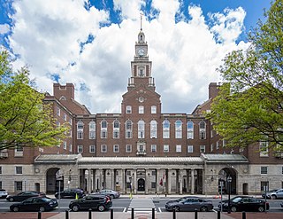
Providence County is the most populous county in the U.S. state of Rhode Island. As of the 2020 census, the county's population was 660,741, or 60.2% of the state's population. Providence County contains the city of Providence, the state capital of Rhode Island and the county's most populous city, with an estimated 190,934 residents in 2020. Providence County is included in the Providence-Warwick, RI-MA Metropolitan Statistical Area, which in turn constitutes a portion of the greater Boston-Worcester-Providence, MA-RI-NH-CT Combined Statistical Area. As of 2010, the center of population in Rhode Island is located in Providence County, in the city of Cranston.

<span class="mw-page-title-main">Melville, Rhode Island</span> CDP in Rhode Island, United States

Melville is a census-designated place (CDP) in the towns of Middletown and Portsmouth in Newport County, Rhode Island, United States. It lies along the shore of Narragansett Bay. The population of the CDP was 1,320 at the 2010 census. The CDP is named after Admiral George Wallace Melville. Past names for the area include Portsmouth Grove and Bradford.

<span class="mw-page-title-main">Newport East, Rhode Island</span> CDP in Rhode Island, United States

Newport East is a census-designated place (CDP) in the town of Middletown, Newport County, Rhode Island, United States. The CDP encompasses the portion of the urban area of the city of Newport that extends beyond the municipal boundaries. The population of the CDP was 11,769 at the 2010 census.

<span class="mw-page-title-main">Cumberland Hill, Rhode Island</span> Census-designated place in Rhode Island, United States

Cumberland Hill is a census-designated place (CDP) in the town of Cumberland, in Providence County, Rhode Island, United States. The population was 7,934 at the 2010 census.

<span class="mw-page-title-main">Glocester, Rhode Island</span> Town in Rhode Island, United States

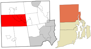
Glocester is a town in Providence County, Rhode Island, United States. The population was 9,974 as of the 2020 census. The villages of Chepachet and Harmony are in Glocester. Putnam Pike runs west through the town center of Glocester into Putnam, Connecticut.

<span class="mw-page-title-main">Greenville, Rhode Island</span> Census-designated place in Rhode Island, United States

Greenville is a village and census-designated place (CDP) in the town of Smithfield in Providence County, Rhode Island, United States. The population was 8,658 at the 2010 census. The CDP is centered on the village of Greenville but also encompasses the nearby villages of West Greenville and Spragueville, as well as the Mountaindale Reservoir and beach.

<span class="mw-page-title-main">Harrisville, Rhode Island</span> Census-designated place in Rhode Island, United States

Harrisville is a census-designated place (CDP) and village in the town of Burrillville in Providence County, Rhode Island, United States. The population was 1,605 at the 2010 census. Much of the community composes a historic district listed on the National Register of Historic Places. The village was named after nineteenth century manufacturer Andrew Harris. Previously, the village was named Rhodesville, after Captain William Rhodes, an eighteenth century privateer.

<span class="mw-page-title-main">Pascoag, Rhode Island</span> Census-designated place in Rhode Island, United States

Pascoag is a census-designated place (CDP) and village in Providence County, Rhode Island. The population was 4,577 at the 2010 census. Pascoag is one of eight villages that make up the town of Burrillville.

<span class="mw-page-title-main">Valley Falls, Rhode Island</span> Village and census-designated place in Rhode Island, US

Valley Falls is a village and census-designated place (CDP) in the town of Cumberland, Providence County, Rhode Island, United States. The population was 12,094 at the 2020 census.

<span class="mw-page-title-main">Woonsocket, Rhode Island</span> City in Rhode Island, United States

Woonsocket, is a city in Providence County, Rhode Island, United States. The population was 43,240 at the 2020 census, making it the sixth largest city in the state. Being Rhode Island's northernmost city, Woonsocket lies directly south of the Massachusetts state line and constitutes part of both the Providence metropolitan area and the larger Greater Boston Combined Statistical Area.

<span class="mw-page-title-main">Bradford, Rhode Island</span> CDP in Rhode Island, United States

Bradford is a census-designated place (CDP) and historic district in the towns of Westerly and Hopkinton in Washington County, Rhode Island, United States. The population was 1,406 at the 2010 census. The Bradford Village Historic District was listed on the National Register of Historic Places in 1996 as a 224-acre (91 ha) area including 149 contributing buildings, one other contributing site, and one other contributing structure. The CDP as defined by the United States Census Bureau is located only in Westerly.

<span class="mw-page-title-main">Hope Valley, Rhode Island</span> Census-designated place in Rhode Island, United States

Hope Valley is a village and census-designated place (CDP) in the town of Hopkinton, Rhode Island, United States. The population of the CDP was 1,612 at the 2010 census. Hope Valley is the largest village in Hopkinton, and the town's principal commercial center. While the village of Hope Valley is located in Hopkinton, its ZIP Code, 02832, extends into the neighboring town of Richmond.

<span class="mw-page-title-main">Narragansett, Rhode Island</span> Town in Rhode Island, United States

Narragansett is a town in Washington County, Rhode Island, United States. The population was 14,532 at the 2020 census. However, during the summer months the town's population more than doubles to near 34,000. The town of Narragansett occupies a narrow strip of land running along the eastern bank of the Pettaquamscutt River to the shore of Narragansett Bay. It was separated from South Kingstown in 1888 and incorporated as a town in 1901.

<span class="mw-page-title-main">Wakefield-Peacedale, Rhode Island</span> CDP in Rhode Island, United States

Wakefield-Peacedale is a census-designated place (CDP) in the town of South Kingstown in Washington County, Rhode Island, United States that includes the villages of Peace Dale and Wakefield. The population was 8,487 at the 2010 census.

<span class="mw-page-title-main">Kingston, Rhode Island</span> Census-designated place in Rhode Island, United States

Kingston is a village and a census-designated place within the town of South Kingstown in Washington County, Rhode Island, United States, and the site of the main campus of the University of Rhode Island. The population was 6,974 at the 2010 census. Much of the village center is listed on the National Register of Historic Places as Kingston Village Historic District. It was originally known as Little Rest.

<span class="mw-page-title-main">Quonochontaug, Rhode Island</span> Village in Rhode Island, United States

Quonochontaug is a village in Washington County, Rhode Island, United States. It is composed of three small beach communities, and is part of Charlestown.

<span class="mw-page-title-main">Weekapaug, Rhode Island</span> Census-designated place in Rhode Island, United States

Weekapaug is a census-designated place in southern Washington County, Rhode Island, part of the town of Westerly, Rhode Island. The population was 425 at the 2010 census.

<span class="mw-page-title-main">Harmony, Rhode Island</span> Census-designated place in Rhode Island, United States

Harmony is a village and census-designated place in Providence County, Rhode Island, in the town of Glocester, located on U.S. Route 44. As of the 2010 census, it had a population of 985.

<span class="mw-page-title-main">Foster Center, Rhode Island</span> United States historic place

Foster Center is a village in the town of Foster, Rhode Island, United States. It was listed as a census-designated place (CDP) in 2010, with a population of 355. Historic elements of the village are included in the Foster Center Historic District, which was added to the National Register of Historic Places on May 11, 1974. The district features various colonial and Greek Revival houses as well as the still functioning town building from the late 18th century.

<span class="mw-page-title-main">Misquamicut, Rhode Island</span> Census-designated place in Rhode Island, United States

Misquamicut is a census-designated place and fire district in southern Washington County, Rhode Island. It is part of the town of Westerly. The population was listed as 390 in 2010.

References

  1. "National Register Information System". National Register of Historic Places . National Park Service. January 23, 2007.
  2. U.S. Geological Survey Geographic Names Information System: Chepachet, Rhode Island
  3. "Profile of General Population and Housing Characteristics: 2010 Demographic Profile Data (DP-1): Chepachet CDP, Rhode Island". United States Census Bureau . Retrieved October 10, 2012.
  4. Thomas Vernon Diary, pg. 76–78
  5. Kent, Edna M. "Betty The Learned Elephant". Chepachet.com. Retrieved February 27, 2013.
  6. "CHEPACHET GLOCESTER, RI – Walking Tour" (PDF). Heritage Corridor Commission. p. 3. Retrieved February 27, 2013. [A]s Betty's show hit the road this time, two of the six youthful conspirators instigated by Smith, aiming from a window in the second story of a gristmill, fired on the elephant as she walked across the "rustic" span. The shots were fatal, and the six hooligans faced charges for their cruel deed
  7. 1 2 3 4 "US Census Bureau, Table DP1: PROFILE OF GENERAL POPULATION AND HOUSING CHARACTERISTICS". data.census.gov. Retrieved December 29, 2023.
  8. Bureau, US Census. "Gazetteer Files". Census.gov. Retrieved December 30, 2023.
  9. "US Census Bureau, Table P1: RACE". data.census.gov. Retrieved December 29, 2023.
  10. "US Census Bureau, Table P2: HISPANIC OR LATINO, AND NOT HISPANIC OR LATINO BY RACE". data.census.gov. Retrieved December 29, 2023.
  11. "US Census Bureau, Table S1101: HOUSEHOLDS AND FAMILIES". data.census.gov. Retrieved December 29, 2023.
  12. "US Census Bureau, Table S1501: EDUCATIONAL ATTAINMENT". data.census.gov. Retrieved December 29, 2023.
  13. "US Census Bureau, Table S1903: MEDIAN INCOME IN THE PAST 12 MONTHS (IN 2020 INFLATION-ADJUSTED DOLLARS)". data.census.gov. Retrieved December 29, 2023.
  14. "US Census Bureau, Table S2001: EARNINGS IN THE PAST 12 MONTHS (IN 2020 INFLATION-ADJUSTED DOLLARS)". data.census.gov. Retrieved December 29, 2023.
  15. "US Census Bureau, Table S1701: POVERTY STATUS IN THE PAST 12 MONTHS". data.census.gov. Retrieved December 29, 2023.
  16. "US Census Bureau, Table S1702: POVERTY STATUS IN THE PAST 12 MONTHS OF FAMILIES". data.census.gov. Retrieved December 29, 2023.
  17. Aldrich, Lewis Cass (1891). History of Franklin and Grand Isle Counties, Vermont. Syracuse, NY: D. Mason & Co. p.  223.

41°54′54″N71°40′17″W / 41.91500°N 71.67139°W / 41.91500; -71.67139