
City Island is a neighborhood in the northeastern Bronx in New York City, located on an island of the same name approximately 1.5 miles (2.4 km) long by 0.5 miles (0.80 km) wide. City Island is located at the extreme western end of Long Island Sound, south of Pelham Bay Park, and east of Eastchester Bay.
The New York City Department of Parks and Recreation, also called the Parks Department or NYC Parks, is the department of the government of New York City responsible for maintaining the city's parks system, preserving and maintaining the ecological diversity of the city's natural areas, and furnishing recreational opportunities for city's residents and visitors.

Pelham Bay Park is a municipal park located in the northeast corner of the New York City borough of the Bronx. It is, at 2,772 acres (1,122 ha), the largest public park in New York City. The park is more than three times the size of Manhattan's Central Park. The park is operated by the New York City Department of Parks and Recreation.

The Pelham Islands are a group of islands in western Long Island Sound that belonged to Thomas Pell in the 17th century. The islands, and most of the surrounding area, were purchased from the Siwanoy Indians by Pell in 1654, creating Pelham Manor. This large tract of land would eventually become the present-day Town and Village of Pelham and Pelham Manor, Town of Eastchester, cities of New Rochelle and Mount Vernon in Westchester County, and the Pelham Bay and Eastchester neighborhoods of the Bronx in New York City.
City Island Harbor is the protected body of water between City Island and Hart Island in the Bronx, New York City, open to Long Island Sound at its northern and southern extremities. It is not a true harbor, but a sound. Other minor islands in and around City Island Harbor include the Chimney Sweeps Islands, the Blauzes, and Rat Island. Green Flats Reef is exposed at low tide.
Cuban Ledge is a reef or islet composed chiefly of sand and small rocks in Eastchester Bay, the Bronx, in Long Island Sound. It is located between Rodman's Neck and Country Club in Eastchester Bay and is visible only during periods of low tide. It is a hazard to boats, and is marked with a signal tower.
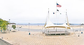
Orchard Beach is the only public beach in the New York City borough of the Bronx. The 115-acre (47 ha), 1.1-mile-long (1.8 km) beach is part of Pelham Bay Park and is situated on the western end of Long Island Sound. The beach consists of a 13-section sandy shorefront, a hexagonal-block promenade, and a central pavilion with food stores and specialty shops. The recreational facilities include two playgrounds, two picnic areas, a large parking lot, and 26 courts for basketball, volleyball, and handball. It is operated by the New York City Department of Parks and Recreation.
Rodman's Neck refers to a peninsula of land in the New York City borough of the Bronx that juts out into Long Island Sound. The southern third of the peninsula is used as a firing range by the New York City Police Department; the remaining wooded section is part of Pelham Bay Park. The north side is joined to what used to be Hunters Island and Twin Island to form Orchard Beach and a parking lot.
Hunter Island is a 166-acre (67 ha) peninsula and former island in the Bronx, New York City, United States. It is situated on the western end of Long Island Sound, along the sound's northwestern shore, and is part of Pelham Bay Park in the northeastern part of the Bronx. Hunter Island initially covered 215 acres (87 ha) and was one of the Pelham Islands, the historical name for a group of islands in western Long Island Sound that once belonged to Thomas Pell. The island is connected to another former island, Twin Island, on the northeast.

Dead Horse Bay is a small body of water off Barren Island, between the Gerritsen Inlet and Rockaway Inlet in the New York City borough of Brooklyn.

The Manhattan Waterfront Greenway is a waterfront greenway for walking or cycling, 32 miles (51 km) long, around the island of Manhattan, in New York City. The largest portions are operated by the New York City Department of Parks and Recreation. It is separated from motor traffic, and many sections also separate pedestrians from cyclists. There are three principal parts — the East, Harlem and Hudson River Greenways.

The East Bronx is the part of the New York City borough of the Bronx which lies east of the Bronx River; this roughly corresponds to the eastern half of the borough. Neighborhoods include: Baychester, Castle Hill, City Island, Co-op City, Country Club, Eastchester, Edenwald, Edgewater Park, Harding Park, Morris Park, Parkchester, Pelham Bay, Pelham Parkway, Soundview, Throggs Neck, Van Nest, Wakefield, Westchester Square, and Williamsbridge.
Westchester Creek is a tidal inlet of the East River located in the south eastern portion of the Bronx in New York City. It is 2.1 miles (3.39 km) in length. The creek formerly traveled further inland, to what is now Pelham Parkway, extending almost to Eastchester Bay and making Throggs Neck into an island during heavy storms. However, much of the route has been filled in, replaced by such structures as the New York City Subway's Westchester Yard and the Hutchinson Metro Center. Westchester Creek's present-day head is at Herbert H. Lehman High School; the remaining portion is largely inaccessible and surrounded by industrial enterprises or empty lots. Westchester Creek is traversed by the Bruckner Interchange at about its midpoint.

Jerome Park Racetrack was an American thoroughbred horse racing facility from 1866 until 1894. It was located in a part of Westchester County, New York that was annexed into the Bronx in 1874. Jerome Park Racetrack was the home of the Belmont Stakes from 1867 until 1889. Today, Jerome Park is the name of a neighborhood adjoining the Jerome Park Reservoir, Bedford Park and Norwood in the northern Bronx.
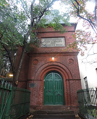
Westchester Square is a residential neighborhood geographically located in the eastern section of the New York City borough of the Bronx. Its boundaries, starting from the north and moving clockwise are: East Tremont Avenue and Silver Street, Blondell Avenue and Westchester Creek to the east, Waterbury Avenue to the south and Castle Hill Avenue to the west. The main roadways through Westchester Square are East Tremont Avenue, Westchester Avenue and Williamsbridge Road.

Fort George Amusement Park was a trolley park and amusement park that operated in the Washington Heights and Inwood neighborhoods of Upper Manhattan, New York City, in the late 19th and early 20th centuries. It occupied an area between 190th and 192nd Streets east of Amsterdam Avenue, within present-day Highbridge Park.

Rattlesnake Creek is an underground waterway in the northeast Bronx, New York City. It flowed above ground level until the mid-20th century, with a waterfall and a pond over its course. Rattlesnake Creek has since been mostly covered over, but a small portion of it is still visible in Seton Falls Park.

