Chinatown is a neighbourhood in Vancouver, British Columbia, and is Canada's largest Chinatown. Centered around Pender Street, it is surrounded by Gastown to the north, the Downtown financial and central business districts to the west, the Georgia Viaduct and the False Creek inlet to the south, the Downtown Eastside and the remnant of old Japantown to the northeast, and the residential neighbourhood of Strathcona to the southeast.

The Center City Commuter Connection (CCCC), commonly referred to as "the commuter tunnel", is a passenger railroad tunnel in Center City, Philadelphia, Pennsylvania, United States, built to connect the stub ends of the two separate regional commuter rail systems, originally operated by two rival railroad companies: the Pennsylvania Railroad and the Reading Company. All of the SEPTA Regional Rail lines except for the Cynwyd Line pass completely through the four-track tunnel, which contains two underground stations, Suburban Station and Jefferson Station, and the above-ground upper-level concourse for the east–west commuter lines serving 30th Street Station.

Interstate 395 (I-395) is an auxiliary Interstate Highway in the US state of Maryland. Known as Cal Ripken Way, the highway runs 1.98 miles (3.19 km) from I-95 north to Howard Street and Camden Street in Downtown Baltimore, where it provides access to the Inner Harbor and the Baltimore Convention Center. The Interstate also serves the Camden Yards Sports Complex, which contains M&T Bank Stadium and Oriole Park at Camden Yards, homes of the Baltimore Ravens and Baltimore Orioles, respectively. I-395 also serves as the southern terminus of Martin Luther King Jr. Boulevard, an urban arterial that provides a western bypass of Downtown Baltimore and connects I-95 with U.S. Route 40 (US 40), US 1, and I-83. The Interstate is maintained by the Maryland Transportation Authority (MDTA) and, like all Interstates, is a part of the National Highway System.

The Chinatown neighborhood in Oakland, California(Chinese: 屋崙華埠), is traditionally Chinese which reflects Oakland's diverse Chinese American, and more broadly Asian American community. It is frequently referred to as "Oakland Chinatown" in order to distinguish it from nearby San Francisco's Chinatown. It lies at an elevation of 39 feet.
Valley Boulevard is a street in Southern California, running east from Los Angeles to Pomona, where it becomes Holt Boulevard, and a continuation from Fontana to Colton. It generally parallels Interstate 10 (I-10) and State Route 60 (CA 60), and is the original alignment of U.S. Route 60 (US 60). The present north end of I-710 is at Valley Boulevard in Los Angeles, just west of Alhambra.

Neighborhoods in Spokane, Washington are officially grouped by the Spokane City Council into three main city council districts: 1, 2, and 3. Each city council district contains multiple, official neighborhoods that are recognized with a neighborhood council. Informally, neighborhoods are colloquially grouped by local geographical, geological, cultural, or historical features The list of neighborhoods below is organized based on the official designations by the City of Spokane. Unofficial neighborhoods and districts are listed within the official neighborhood in which they are located.

Downtown San Diego is the city center of San Diego, California, the eighth largest city in the United States. In 2010, the Centre City area had a population of more than 28,000. Downtown San Diego serves as the cultural and financial center and central business district of San Diego, with more than 4,000 businesses and nine districts. The downtown area is the home of the San Diego Symphony and the San Diego Opera as well as multiple theaters and several museums. The San Diego Convention Center and Petco Park, home of the San Diego Padres, are also located downtown. Downtown San Diego houses the major local headquarters of the city, county, state, and federal governments.
Downtown Spokane or Riverside is the central business district of Spokane, Washington. The Riverside neighborhood is roughly bounded by I-90 to the south, Division Street to the east, Monroe Street to the west and Boone Avenue to the north. The topography of Downtown Spokane is mostly flat except for areas downstream of the Spokane Falls which are located in a canyon; the elevation is approximately 1,900 feet (580 m) above sea level.
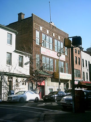
The Hip Sing Association or HSA, formerly known as the Hip Sing Tong, is a Chinese-American criminal organization/gang formed as a labor organization in New York City's Chinatown during the early 20th century. The Cantonese name "Hip Sing" translates roughly to "cooperating for success." The Hip Sing Tong, along with their rivals the Four Brothers and the On Leong Tong, would be involved in violent Tong wars for control of Chinatown during the early 1900s. During the 1930s and 1940s, the Hip Sings were involved in drug trafficking operations with the Kuomintang (KMT) and later the Office of Policy Coordination (OPC). They would later establish chapters in Chinese-American communities throughout the United States in major cities such as Chicago, Seattle and San Francisco. Recently some branches have begun to transform back into the legitimate fraternal organization they started as over a century prior.

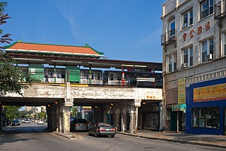
Doyers Street is a 200-foot-long (61 m) street in the Chinatown neighborhood of Manhattan in New York City. It is one block long with a sharp bend in the middle. The street runs south and then southeast from Pell Street to the intersection of Bowery, Chatham Square, and Division Street. Doyers Street contains several restaurants, barber shops, and hair stylists, as well as the Chinatown branch of the United States Postal Service. The Nom Wah Tea Parlor opened at 13 Doyers Street in 1920, and is still in operation; other longstanding business include Ting's Gift Shop at 18 Doyers which opened in 1957.

Linden Boulevard is a boulevard in New York City. Its western end is at Flatbush Avenue in Brooklyn, where Linden Boulevard travels as an eastbound-only street to Caton Avenue, where it becomes a two-way street. The boulevard stretches through both Brooklyn and Queens. This boulevard, especially the area of Cambria Heights between Springfield Boulevard and the Nassau County line represents a smaller version of shopping centers located on Jamaica Avenue and Queens Boulevard. Linden Boulevard also continues into Nassau County to Valley Stream where it turns into Central Avenue; this was one of several former names of the street in Queens.
West Argyle Street Historic District is a historic district in northern Uptown, Chicago, Illinois. It was listed on the National Register of Historic Places on June 3, 2010. The community covers an area of about 41 acres (0.17 km2); its rough boundaries are N. Glenwood Ave to the west, Winona Street to the north, Sheridan Road to the east, and Ainslie Street to the south.

Interstate 90 Business may refer to several business routes of the Interstate Highway System that connects Interstate 90 with the central business district of various cities bypassed by I-90. Each business route can be either a business loop or a business spur, depending on whether both ends connect to I-90. The business route in each community is considered a unique route. In many cases, these routes are a former section of a U.S. Route.

Chinatowns are enclaves of Chinese people outside of China. The first Chinatown in the United States was San Francisco's Chinatown in 1848, and many other Chinatowns were established in the 19th century by the Chinese diaspora on the West Coast. By 1875, Chinatowns had emerged in eastern cities such as New York City, Boston, and Philadelphia. The Chinese Exclusion Act of 1882 barred Chinese immigration to the United States, but the Magnuson Act of 1943 repealed it, and the population of Chinatowns began to rise again. In the 2010s, the downturn in the U.S. economy caused many Chinese Americans to return to China.

The U.S. city of Pittsburgh, Pennsylvania was home to a "small, but busy" Chinatown, located at the intersection of Grant Street and Boulevard of the Allies in Downtown Pittsburgh where only two Chinese restaurants remain. The On Leong Society was located there. According to the article, "... the first Chinese community in Pittsburgh developed around Wylie Avenue above Court Place," according to a 1942 newsletter of the American Service Institute of Allegheny County. The Chinatown spread to Grant Street, and then "... to Water Street and then spread out to Second and Third avenues."
The U.S. city of Baltimore, Maryland is home to a small Chinatown. Historically, Baltimore had at least two districts that were called "Chinatown" where the first one existed on the 200 block of Marion Street during the 1880s. A second and current location is at the 300 block of Park Ave., which was dominated by laundries and restaurants. The initial Chinese population came because of the transcontinental railroad, however, the Chinese population never exceeded 400 as of 1941. During segregation, Chinese children were classified as "white" and went to the white schools. Chinatown was largely gone by the First World War due to urban renewal. Although Chinatown was largely spared from the riots of the 1960s, most of the Chinese residents moved to the suburbs. As of 2009, the area still shows signs of blight and does not have a Chinese arch. As of 2017, the area has become an “immigration hub” for Ethiopian people. In 2018, a mural of a Chinese dragon and an African lion was painted to signify the past as a Chinatown and the present as an African neighborhood. A night market in September 2018 marked the first Asian celebration of the area to an area that was “long forgotten and neglected”.
Division Street is a major north–south street in Spokane, Washington, United States. It travels approximately 11 miles (18 km) through a majority of the city, albeit non-contiguously through its southern portions, extending from the South Hill to Spokane's northern border and beyond into Spokane County, where it intersects with the North Spokane Corridor.

Sprague Avenue is a major east–west street serving Spokane, Spokane Valley, and Liberty Lake, Washington, United States. It travels approximately 17 miles (27 km), extending from Downtown Spokane eastward through Spokane Valley as an arterial road, and continues on as a collector road to its eastern terminus in Liberty Lake.

Logan is a neighborhood in Spokane, Washington. It is located immediately northeast of Downtown Spokane and is home to Gonzaga University. The Spokane River runs along its eastern and southern edge. Due to its proximity to the city center, Logan is home to some of the oldest and densest areas in the city. It is known for its tree-lined streets, historic buildings and population of college students. In addition to numerous individual properties, there are two historic districts listed on the National Register of Historic Places located within Logan: the Desmet Avenue Warehouse Historic District and the Mission Avenue Historic District.

East Central is a neighborhood in Spokane, Washington. As the name suggests, it is on the east side of Spokane and centrally located. The official neighborhood is expansive and covers multiple areas considered by locals to be independent neighborhoods, such as the Sprague Union District on East Sprague Avenue, the South Perry District, the Underhill Park area and the University District on the eastern fringe of Downtown Spokane.