Related Research Articles

The Gulf of St. Lawrence is the outlet of the North American Great Lakes via the St. Lawrence River into the Atlantic Ocean. The gulf is a semi-enclosed sea, covering an area of about 226,000 square kilometres (87,000 sq mi) and containing about 34,500 cubic kilometres (8,300 cu mi) of water, at an average depth of 152 metres (500 ft).

Calais is a city in Washington County, Maine, United States. As of the 2020 census, it had a population of 3,079, making Calais the third least-populous city in Maine. The city has three Canada–US border crossings over the St. Croix River connecting to St. Stephen, New Brunswick, Canada.
Vanceboro is a town in Washington County, Maine, United States. The town was named after landowner William Vance. The main village in town is located at the eastern terminus of Maine State Route 6. Vanceboro is across the St. Croix River from St. Croix, New Brunswick, Canada, to which it is connected by the Saint Croix–Vanceboro Bridge. The crossing has a 24-hour customs station managing the border. Vanceboro is also connected to St. Croix by the Saint Croix–Vanceboro Railway Bridge which is used by the New Brunswick Southern Railway.

St. Stephen is a Canadian town in Charlotte County, New Brunswick, situated on the east bank of the St. Croix River around the intersection of New Brunswick Route 170 and the southern terminus of New Brunswick Route 3. The St. Croix River marks a section of the Canada–United States border, forming a natural border between Calais, Maine and St. Stephen. U.S. Route 1 parallels the St. Croix river for a few miles, and is accessed from St. Stephen by three cross-border bridges.

The St. Croix River is a river in northeastern North America, 71 miles (114 km) in length, that forms part of the Canada–United States border between Maine (U.S.) and New Brunswick (Canada). The river rises in the Chiputneticook Lakes and flows south and southeast, between Calais and St. Stephen. It discharges into Passamaquoddy Bay, in the Bay of Fundy.

The border between Canada and the United States is the longest international border in the world. The terrestrial boundary is 8,891 kilometers (5,525 mi) long. The land border has two sections: Canada's border with the contiguous United States to its south, and with the U.S. state of Alaska to its west. The bi-national International Boundary Commission deals with matters relating to marking and maintaining the boundary, and the International Joint Commission deals with issues concerning boundary waters. The agencies currently responsible for facilitating legal passage through the international boundary are the Canada Border Services Agency (CBSA) and U.S. Customs and Border Protection (CBP).

Machias Seal Island is an island in disputed water between the Gulf of Maine and the Bay of Fundy, about 16 km (10 mi) southeast from Cutler, Maine, and 19 km (12 mi) southwest of Grand Manan Island, New Brunswick. Sovereignty of the island is disputed by the United States and Canada. The Canadian Coast Guard continues to staff a lighthouse on the island; the first lighthouse was constructed there in 1832.
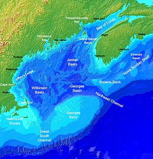
The Gulf of Maine is a large gulf of the Atlantic Ocean on the east coast of North America. It is bounded by Cape Cod at the eastern tip of Massachusetts in the southwest and by Cape Sable Island at the southern tip of Nova Scotia in the northeast. The gulf includes the entire coastlines of the U.S. states of New Hampshire and Maine, as well as Massachusetts north of Cape Cod, and the southern and western coastlines of the Canadian provinces of New Brunswick and Nova Scotia, respectively.

Passamaquoddy Bay is an inlet of the Bay of Fundy, between the U.S. state of Maine and the Canadian province of New Brunswick, at the mouth of the St. Croix River. Most of the bay lies within Canada, with its western shore bounded by Washington County, Maine. The southernmost point is formed by West Quoddy Head on the U.S. mainland in Lubec, Maine; and runs northeasterly through Campobello Island, New Brunswick, engulfing Deer Island, New Brunswick, to the New Brunswick mainland head at L'Etete, New Brunswick in Charlotte County, New Brunswick.

Chignecto Bay is an inlet of the Bay of Fundy located between the Canadian provinces of New Brunswick and Nova Scotia and separated from the waters of the Northumberland Strait by the Isthmus of Chignecto. It is a unit within the greater Gulf of Maine Watershed. Chignecto Bay forms the northeastern part of the Bay of Fundy which splits at Cape Chignecto and is delineated on the New Brunswick side by Martin Head. Chignecto bay was also the site of an unsuccessful railway and canal project of the 1880s and 1890s that would have intersected the landmass, thereby providing a transit passage between New England and Prince Edward Island. After several investigations into the feasibility of a new canal project, including most importantly by the Chignecto Canal Commission, the proposed Chignecto Canal was deemed commercially and economically unjustifiable and the project was abandoned. Some of the physical remnants of the 1880s project still continue to dot the landscape of Chignecto Bay today.
The New Brunswick Southern Railway Company Limited is a 131.7 mi (212.0 km) Canadian short line railway owned by the New Brunswick Railway Company Limited, a holding company that is part of "Irving Transportation Services", a division within the industrial conglomerate J.D. Irving Limited.
Forest City is a rural community in York County, New Brunswick, Canada.

The history of post-confederation Canada began on July 1, 1867, when the British North American colonies of Canada, New Brunswick, and Nova Scotia were united to form a single Dominion within the British Empire. Upon Confederation, the United Province of Canada was immediately split into the provinces of Ontario and Quebec. The colonies of Prince Edward Island and British Columbia joined shortly after, and Canada acquired the vast expanse of the continent controlled by the Hudson's Bay Company, which was eventually divided into new territories and provinces. Canada evolved into a fully sovereign state by 1982.

The St. Francis River is a river roughly 75 miles (120 km) long, which forms part of the Canada–United States border. The river rises in a lake of the same name located 12 miles (20 km) east of the Rivière du Loup in Quebec. The portion that forms the boundary starts at the bottom of Lake Pohenegamook at the very northernmost point of New England between Estcourt Station, Maine, and Estcourt, Quebec. The river along the international boundary flows south and then south-east through two deep, narrow lakes to its mouth on the Saint John River at St. Francis, Maine/Saint-François-de-Madawaska, New Brunswick.
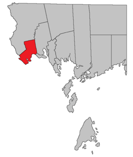
St. Croix is a rural community in York County, New Brunswick, Canada.
Spednic Lake is a mesotrophic lake in the Chiputneticook Lakes chain along the Canada–United States border between the state of Maine and the province of New Brunswick that is best known for its bass fishing. Sometimes it is viewed as the headwaters of the St. Croix River, sometimes a lake further up the chain is considered the headwaters. The international border runs through the lake. A northeastern arm of the lake, located entirely in Canada, retains the name Palfrey Lake. Prior to dam construction that expanded Spednic Lake they were separate lakes, but now they are hydrologically and ecologically a single combined lake.
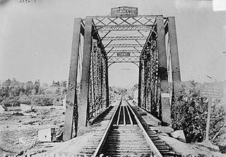
The Saint Croix–Vanceboro Railway Bridge is a 100-foot-long (30 m) railway bridge crossing the St. Croix River from St. Croix, New Brunswick, Canada, to Vanceboro, Maine, United States. A deck truss design, it is owned and operated by the New Brunswick Southern Railway.

Saint Croix is a civil parish in Charlotte County, New Brunswick, Canada, straddling Route 1 to the north of Saint Andrews, New Brunswick. It comprises two local service districts, both of which are members of the Southwest New Brunswick Service Commission (SNBSC).
Saint Stephen is a civil parish in Charlotte County, New Brunswick, Canada, located in the southwestern corner of the province. It comprises one town, two local service districts (LSDs), and part of a third LSD, all of which are members of the Southwest New Brunswick Service Commission (SNBSC).

Saint David is a civil parish in Charlotte County, New Brunswick, Canada, located northeast of St. Stephen and northwest of Saint Andrews. It comprises a single local service district (LSD), which is a member of the Southwest New Brunswick Service Commission (SNBSC).
References
- Emerson, Walter Crane (1916). The Latchstring to Maine Woods and Waters. New York: Houghton Mifflin. OCLC 2019359.
- Marble, Albert P (1885). Geography and History of Maine. Worcester, Mass: Worcester Society of Antiquity. OCLC 12959679.
Coordinates: 45°40′N67°45′W / 45.667°N 67.750°W
- ↑ Hamilton, William (1978). The Macmillan Book of Canadian Place Names. Toronto: Macmillan. p. 73. ISBN 0-7715-9754-1.