
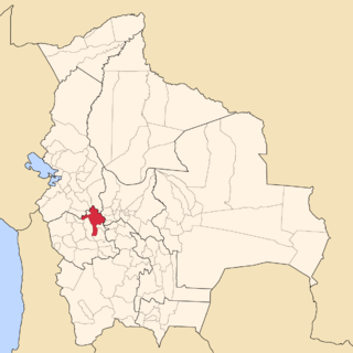
Tiwanaku is a Pre-Columbian archaeological site in western Bolivia near Lake Titicaca, about 70 kilometers from La Paz, and it is one of the largest sites in South America. Surface remains currently cover around 4 square kilometers and include decorated ceramics, monumental structures, and megalithic blocks. The site's population probably peaked around AD 800 with 10,000 to 20,000 people.

La Venta is a pre-Columbian archaeological site of the Olmec civilization located in the present-day Mexican state of Tabasco. Some of the artifacts have been moved to the museum "Parque - Museo de La Venta", which is in nearby Villahermosa, the capital of Tabasco.

Monte Albán is a large pre-Columbian archaeological site in the Santa Cruz Xoxocotlán Municipality in the southern Mexican state of Oaxaca. The site is located on a low mountainous range rising above the plain in the central section of the Valley of Oaxaca, where the latter's northern Etla, eastern Tlacolula, and southern Zimatlán and Ocotlán branches meet. The present-day state capital Oaxaca City is located approximately 9 km (6 mi) east of Monte Albán.
Pre-Columbian art refers to the visual arts of indigenous peoples of the Caribbean, North, Central, and South Americas from at least 13,000 BCE to the European conquests starting in the late 15th and early 16th centuries. The Pre-Columbian era continued for a time after these in many places, or had a transitional phase afterwards. Many types of perishable artifacts that were no doubt once very common, such as woven textiles, typically have not been preserved, but Precolumbian monumental sculpture, metalwork in gold, pottery, and painting on ceramics, walls, and rocks have survived more frequently.

Cuicuilco is an important archaeological site located on the southern shore of Lake Texcoco in the southeastern Valley of Mexico, in what is today the borough of Tlalpan in Mexico City. Some historians believe this settlement goes back to 1400 BC. Other historians believe the pyramid could be the oldest building in the Americas circa 6,500 BC.

Chalcatzingo is a Mesoamerican archaeological site in the Valley of Morelos dating from the Formative Period of Mesoamerican chronology. The site is well known for its extensive array of Olmec-style monumental art and iconography. Located in the southern portion of the Central Highlands of Mexico, Chalcatzingo is estimated to have been settled as early as 1500 BCE. The inhabitants began to produce and display Olmec-style art and architecture around 900 BCE. At its height between 700 BCE and 500 BCE, Chalcatzingo's population is estimated at between five hundred and a thousand people. By 500 BCE it had gone into decline. The climate in Morelos is generally warmer and more humid than the rest of the Highlands. The Chalcatzingo center covers roughly 100 acres (0.40 km2). Evidence indicates that this was a site of ritual significance.

Isla del Sol is an island in the southern part of Lake Titicaca. It is part of Bolivia, and specifically part of the La Paz Department. Geographically, the terrain is harsh; it is a rocky, hilly island with many eucalyptus trees. There are no motor vehicles or paved roads on the island. The main economic activity of the approximately 800 families on the island is farming, with fishing and tourism augmenting the subsistence economy. Of the several villages, Yumani and Challapampa are the largest.

San Lorenzo Tenochtitlán or San Lorenzo is the collective name for three related archaeological sites—San Lorenzo, Tenochtitlán and Potrero Nuevo—located in the southeast portion of the Mexican state of Veracruz. Along with La Venta and Tres Zapotes, it was one of the three major cities of the Olmec, and the major center of Olmec culture from 1200 BCE to 900 BCE. San Lorenzo Tenochtitlán is best known today for the colossal stone heads unearthed there, the greatest of which weigh 28 metric tons or more and are 3 metres (9.8 ft) high.
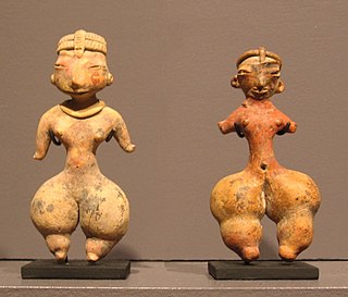
Tlatilco culture is a culture that flourished in the Valley of Mexico between the years 1250 BCE and 800 BCE, during the Mesoamerican Early Formative period. Tlatilco, Tlapacoya, and Coapexco are the major Tlatilco culture sites.

Chiapa de Corzo is an archaeological site of pre-Columbian Mesoamerica located near the small town of Chiapa de Corzo, Chiapas.

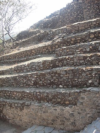
Pumapunku or Puma Punku is a 6th-century T-shaped and strategically aligned man-made terraced platform mound with a sunken court and monumental structure on top that is part of the Pumapunku complex, at the Tiwanaku Site near Tiwanacu, in western Bolivia. The Pumapunku complex is an alignment of plazas and ramps centered on the Pumapunku platform mound. Today the monumental complex on top of the platform mound lies in ruins.

The Andean civilizations were complex societies of many cultures and peoples mainly developed in the river valleys of the coastal deserts of Peru. They stretched from the Andes of southern Colombia southward down the Andes to Chile and northwest Argentina. Archaeologists believe that Andean civilizations first developed on the narrow coastal plain of the Pacific Ocean. The Caral or Norte Chico civilization of Peru is the oldest known civilization in the Americas, dating back to 3200 BCE.
San Miguel Ixtapan is an archaeological site located in the municipality of Tejupilco, in the State of Mexico.

Ixtlán del Rio is an archaeological site located in the Ixtlán del Rio municipality, on the south west region of the Nayarit State, Mexico. It is also known as "Los Toriles" and contains the only vestiges of the western cultures in Nayarit.
The Pucará culture was an archaeological culture which developed in Qullaw, along the north-western shore of Lake Titicaca. It was characterized by a hierarchy of sites made up several smaller centers and villages scattered throughout the northern basin of the Titicaca, ruled from its nucleus - the town of Pukara with an approximate extension of 6 square kilometers, constituted the first properly urban settlement in the Titicaca basin. Its sphere of influence reached as far north as the Cuzco Valley and as far south as Tiahuanaco. The culture had two phases of development within the Formative Period: the Middle Formative, and Late Formative.

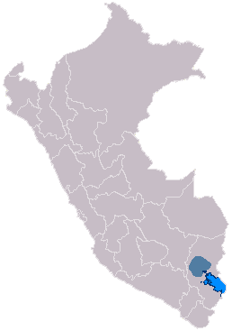
Pucará, Puno is a town in the Puno Region, Lampa Province, Pucará District, Peru. It is located to the north-west of Lake Titicaca.

The Tiwanaku Polity was a Pre-Columbian polity in western Bolivia based in the southern Lake Titicaca Basin. Tiwanaku was one of the most significant Andean civilizations. Its influence extended into present-day Peru and Chile and lasted from around 600 to 1000 AD. Its capital was the monumental city of Tiwanaku, located at the center of the polity's core area in the southern Lake Titicaca Basin. This area has clear evidence for large-scale agricultural production on raised fields that probably supported the urban population of the capital. Researchers debate whether these fields were administered by a bureaucratic state (top-down) or through a federation of communities with local autonomy. Tiwanaku was once thought to be an expansive military empire, based mostly on comparisons to the later Inca Empire. However, recent research suggests that labelling Tiwanaku as an empire or even different varieties of a state may even be misleading. Tiwanaku is missing a number of features used to define these types of polities: there is no defensive architecture at any Tiwanaku site or changes in weapon technology, there are no princely burials or other evidence of a ruling dynasty or a formal social hierarchy, no evidence of state-maintained roads or outposts, and no markets.
Sonia Alconini Mujica is a Bolivian anthropologist and archaeologist specializing in the socioeconomic and political development of early states and empires in the Andes. She has studied the dynamics of ancient imperial frontiers, and the ways in which Guarani tropical tribes expanded over these spaces. She has also conducted work in the eastern Bolivian valleys and Lake Titicaca region.

Pre-Columbian Bolivia covers the historical period between 10,000 BCE, when the Upper Andes region was first populated and 1532, when Spanish conquistadors invaded Inca empire. The Andes region of Pre-Columbian South America was dominated by the Tiwanaku civilization until about 1200, when the regional kingdoms of the Aymara emerged as the most powerful of the ethnic groups living in the densely populated region surrounding Lake Titicaca. Power struggles continued until 1450, when the Incas incorporated upper Bolivia into their growing empire. Based in present-day Peru, the Incas instituted agricultural and mining practices that rivaled those put in place many years later by European conquerors. They also established a strong military force, and centralized political power. Despite their best efforts however, the Incas never completely controlled the nomadic tribes of the Bolivian lowlands, nor did they fully assimilate the Aymara kingdoms into their society. These internal divisions doomed the Inca Empire when European conquerors arrived.
The Wankarani culture was a formative stage culture that existed from approximately 1500 BCE to 400 CE on the altiplano highlands of Bolivia's Oruro Department to the north and northeast of Lake Poopo. It is the earliest known sedentary culture in Bolivia, as after circa 1200 BCE camelid hunters of the altiplano became camelid herders and sedentary lifestyle developed. The Wankarani culture was little researched before 1970, when Carlos Ponce Sanginés defined all the mound sites in the area as belonging to one culture that predated Tiwanaku and was contemporary with the Chiripa culture.

