Chitral

Last updated

Chitral
  • ݯھیترار
  • چترال
Chitral montage.jpg
Clockwise from top:
Nickname: 
Qāshqār
Pakistan Khyber Pakhtunkhwa location map.svg
Red pog.svg
Chitral
Pakistan location map.svg
Red pog.svg
Chitral
Coordinates: 35°50′46″N71°47′09″E / 35.84611°N 71.78583°E / 35.84611; 71.78583
CountryFlag of Pakistan.svg  Pakistan
Province PK-NWFP.svg  Khyber Pakhtunkhwa
District Lower Chitral
Established1885;139 years ago (1885)
Founded byBritish government
Named for Field
Government
[1]
  Type Municipal Corporation
  Body District Government
   Mayor (Lower Chitral)Shahzada Aman Ur Rehman [2] (PTI)
Area
  Total14,850 km2 (5,730 sq mi)
Elevation
[3]
1,494 m (4,902 ft)
Population
 (2017) [4]
  Total49,780
  Density3.4/km2 (8.7/sq mi)
Demonym Chitralis
Languages
  Official Urdu [5]
  Regional Chitrali [5]
Time zone UTC+5:00 (Pakistan Standard Time)
Zip Code
17200 [6] [7]
Area code 0943
Vehicle registration CL
Website lowerchitral.kp.gov.pk

Chitral (Khowar : ݯھیترار, romanized: ćhitrār, lit. 'field') is a city situated on the Chitral River in northern area of Khyber Pakhtunkhwa. It serves as the capital of the Lower Chitral District, and was previously the capital of Chitral District, and before that the capital of Chitral princely state. The region was encompassed into West Pakistan between the years 1969 and 1972. It has a population of 49,780 per the 2017 census. [4]

Contents

History

Nothing definitive is recorded about the town’s first settlers. In the 3rd century AD, Kanishka, the Buddhist ruler of the Kushan empire, occupied Chitral. In the 4th century AD, the Chinese overran the valley. Raees rule over Chitral began in 1320 and came to an end in the 15th century. From 1571 onwards Chitral was the capital of the princely state of Chitral under the rule of the Katur Dynasty. [8]

Ancient era

Gankoreneotek Grave in Singoor. Singoor.png
Gankoreneotek Grave in Singoor.

The existence of the Gandharan Grave Culture in Chitral, [9] found in various grave sites scattered over its valleys gives an insightful knowledge of its inhabitants following the Indo-Aryan migrations, after the decline of Indus Valley civilization. [10] [11] The Gankorineotek cemetery in Singoor is home to several ancient burial sites, dating back to the Vedic period. [12] [13] [14]

The area which now forms Chitral was reportedly conquered by the Persian Achaemenids and was a part of one of their easternmost satraps. [15] In the third century CE, Kanishka, the Buddhist ruler of the Kushan empire, occupied Chitral. Under the Kushans, many Buddhist monuments were built around the area, mainly Buddhist stupas and monasteries. The Kushans also patronised Buddhist art; some of the finest examples of the image of Buddha were produced in the region under the Kushan rule. [16]

Kator era

Chitral's Shahi Mosque Shahi Mosque, Chitral.jpg
Chitral's Shahi Mosque

From 1571 to 1969, Chitral was the dominion of the Kator Dynasty. [17] [ failed verification ] The British and Sikh garrison suffered a siege by the Chitralis, possibly aided by Afghan forces, in 1895. The garrison was relieved after six weeks, and the British installed the young Shuja ul-Mulk as Mehtar ("ruler"). He ruled for the next 41 years. [18]

Accession to Pakistan

In 1947, following the division of the British colony of India, princely states were offered the choice to either remain independent or to choose one of the two new dominions. Initially, Chitral chose to remain an independent Monarchy. Later, the Mehtar of Chitral, who was a friend of Quaid E Azam Mohammad Ali Jinnah, acceded to Pakistan and thus Chitral became one of the princely states of Pakistan. Through 1969 to 1972, it was fully integrated into Pakistan as the administrative district of Chitral. [19]

Role in the First Kashmir War

Chitral played an instrumental role in the 1947–1948 first Kashmir war. Immediately after acceding to Pakistan, Mehtar Muzaffar ul-Mulk proclaimed Jihad to 'liberate' Kashmir from the Dogras. At this point, the Gilgit scouts were retreating and the Dogra forces had made gains in the Burzil pass. Under these circumstances, the Chitral scouts relieved the Gilgit scouts in Domel and Kamri sectors whilst the Chitral Bodyguard force went towards Skardu. The Chitral bodyguards under the leadership of a Chitral Prince laid one of the longest sieges in military history which ended with the fall of Skardu, the surrender of the Dogras, and the capture of Baltistan. During this time, the Chitral scouts assimilated with the Gilgit scouts and went on towards taking the Kargil pass. [20]

Geography

Chitral city City of Chitral.jpg
Chitral city

The city has an average elevation of 1,500 m (4,921 ft).

Climate

In contrast to more southerly valleys of Khyber Pakhtunkhwa, Chitral has a dry Mediterranean climate (Köppen Csa) with almost no rainfall during the very hot summers. Precipitation occurs mainly from spring thunderstorms brought about by western frontal systems. In the winter the nighttime temperature occasionally drops to −10 °C. Winter snowfall in the town can be quite heavy with an accumulation of up to 60 cm being quite common, at higher elevations snowfall can reach as high as 20 metres (70 ft)[ citation needed ].

Climate data for Chitral, Khyber Pakhtunkhwa
MonthJanFebMarAprMayJunJulAugSepOctNovDecYear
Record high °C (°F)16.9
(62.4)
21.0
(69.8)
28.0
(82.4)
34.3
(93.7)
38.3
(100.9)
42.5
(108.5)
44.4
(111.9)
42.2
(108.0)
39.8
(103.6)
34.4
(93.9)
27.0
(80.6)
20.7
(69.3)
44.4
(111.9)
Mean daily maximum °C (°F)8.8
(47.8)
9.9
(49.8)
15.1
(59.2)
22.5
(72.5)
28.2
(82.8)
34.4
(93.9)
35.9
(96.6)
34.4
(93.9)
31.1
(88.0)
25.1
(77.2)
18.7
(65.7)
11.6
(52.9)
23.0
(73.4)
Daily mean °C (°F)4.1
(39.4)
5.3
(41.5)
9.6
(49.3)
15.5
(59.9)
20.3
(68.5)
26.1
(79.0)
28.0
(82.4)
26.5
(79.7)
22.1
(71.8)
16.2
(61.2)
10.8
(51.4)
5.9
(42.6)
15.9
(60.6)
Mean daily minimum °C (°F)−0.6
(30.9)
0.6
(33.1)
4.2
(39.6)
8.5
(47.3)
12.5
(54.5)
17.8
(64.0)
20.2
(68.4)
18.7
(65.7)
13.1
(55.6)
7.2
(45.0)
2.9
(37.2)
0.2
(32.4)
8.8
(47.8)
Record low °C (°F)−11.0
(12.2)
−11.0
(12.2)
−3.7
(25.3)
0.0
(32.0)
4.4
(39.9)
8.9
(48.0)
11.1
(52.0)
10.6
(51.1)
5.6
(42.1)
1.1
(34.0)
−3.0
(26.6)
−12.2
(10.0)
−12.2
(10.0)
Average precipitation mm (inches)38.4
(1.51)
63.8
(2.51)
97.3
(3.83)
71.7
(2.82)
43.9
(1.73)
5.1
(0.20)
4.9
(0.19)
8.0
(0.31)
7.3
(0.29)
15.6
(0.61)
20.4
(0.80)
38.5
(1.52)
414.9
(16.32)
Mean monthly sunshine hours 134.0133.7150.4188.6247.0286.3285.4258.6231.0214.0182.5130.72,442.2
Source: NOAA (1971-1990) [21]

Demographics

Urdu is the official language of the city. [5] According to the 1981 census, Khowar is the main language and is spoken by 98% of the population. Kalasha is also spoken by a small population. [22]

As per the 2017 census, Chitral has a population of 49,780. [4]

Historical demographics

Religion in the town of Chitral
ReligionPopulation (1901) [23] Percentage (1901)
Islam Star and Crescent.svg 3,452
Hinduism Om.svg 2,709
Sikhism Khanda.svg 1,826
Total8,128

Educational institutions

Notable people

See also

Related Research Articles

<span class="mw-page-title-main">Baltistan</span> Region of Pakistani-administered Kashmir

Baltistan also known as Baltiyul or Little Tibet, is a mountainous region in the Pakistani-administered territory of Gilgit-Baltistan and constitutes an northern portion of the larger Kashmir region that has been the subject of a dispute between India and Pakistan since 1947. It is located near the Karakoram and borders Gilgit to the west, China's Xinjiang to the north, Indian-administered Ladakh to the southeast, and the Indian-administered Kashmir Valley to the southwest. The average altitude of the region is over 3,350 metres (10,990 ft). Baltistan is largely administered under the Baltistan Division.

<span class="mw-page-title-main">Gilgit</span> Capital city in Gilgit–Baltistan, a region administered by Pakistan

Gilgit is a city in Pakistani-administered Gilgit–Baltistan in the disputed Kashmir region. It is the capital of the Gilgit-Baltistan region. The city is located in a broad valley near the confluence of the Gilgit and the Hunza rivers. It is a major tourist destination in Pakistan, serving as a hub for trekking and mountaineering expeditions in the Karakoram mountain range.

<span class="mw-page-title-main">Chitral District</span> Former district of Khyber Pakhtunkhwa, Pakistan; 1969–2018

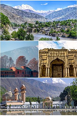
Chitral District was a district in the Malakand Division of the Pakistani province of Khyber Pakhtunkhwa, from 14 August 1947 to 2018. It was the largest district in the Khyber-Pakhtunkhwa, covering an area of 14,850 km2, before splitting into Upper and Lower Chitral Districts in 2018. It was the northernmost district of Khyber Pakhtunkhwa. It shared a border with Gilgit-Baltistan to the east and with Swat and Dir districts of Khyber Pakhtunkhwa to the south. It also shared an international border with Afghanistan to the north and west. Afghanistan's narrow strip of Wakhan Corridor separated Chitral from Tajikistan in the north.

<span class="mw-page-title-main">Gilgit Agency</span> Agency of the British Indian Empire & later Pakistan

The Gilgit Agency was an agency within the British Indian Empire. It encompassed the subsidiary states of the princely state of Jammu and Kashmir situated along the northern border. The primary objective of establishing the Gilgit Agency was to bolster and fortify these regions, particularly in the context of concerns about Russian encroachment in the area. The subsidiary states encompassed Hunza, Nagar and other states in the present day districts of Gupis-Yasin, Ghizer, Darel, Tangir and Diamer. The agency headquarters was based in the town of Gilgit, within the Gilgit tehsil of Jammu and Kashmir.

<span class="mw-page-title-main">Swat District</span> District in Khyber Pakhtunkhwa, Pakistan

Swat District, also known as the Swat Valley, is a district in the Malakand Division of Khyber Pakhtunkhwa, Pakistan. Known for its stunning natural beauty, the district is a popular tourist destination. With a population of 2,309,570 per the 2017 national census, Swat is the 15th-largest district of Khyber Pakhtunkhwa.

<span class="mw-page-title-main">Dardistan</span> Region in South Asia

Dardistan refers to a region where Dardic languages are spoken. The terms "Dardic" and "Dardistan" are not indigenous to the region, and were coined by Gottlieb Wilhelm Leitner. The legitimacy of the term has been called into question. The region also includes a number of non-Dardic peoples and languages.

<span class="mw-page-title-main">Yasin Valley</span> Valley in Gilgit Baltistan, Pakistan

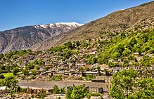
Yasin Valley is a high-altitude mountain valley nestled in the Hindu Kush mountain range, located in the northern region of the Gupis-Yasin District within the territory of Gilgit-Baltistan, Pakistan. The valley is situated approximately 148 kilometers away from the city of Gilgit, which serves as the capital of Gilgit-Baltistan. Within the valley's territory lies the Yasin Tehsil, an administrative subdivision of the region.

<span class="mw-page-title-main">Chilas</span> City administered by Pakistan in Gilgit-Baltistan

Chilas is a city in Pakistani-administered Gilgit–Baltistan in the disputed Kashmir region. It is the divisional capital of Diamer Division and is located on the Indus River. It is part of the Silk Road, connected by the Karakoram Highway and N-90 National Highway to Islamabad and Peshawar in the southwest, via Hazara and Malakand divisions of Khyber Pakhtunkhwa. To the north, Chilas connects to the cities of Tashkurgan and Kashgar in Xinjiang, China, via Gilgit, Aliabad, Sust, and the Khunjerab Pass.

<span class="mw-page-title-main">Nagarkhas</span> Place in Gilgit–Baltistan, Pakistan

Nagarkhas, also known as Oyum-Nagar, serves as the administrative center for the Nagar District in Gilgit–Baltistan region of Pakistan and is one of the main towns of the district. Located along the Nagar River, this town also held the distinction of being the capital of the erstwhile princely state of Nagar.

<span class="mw-page-title-main">Nagar Valley</span> Valley in Gilgit Baltistan, Pakistan.

Nagar Valley once a princely state, now stands as one of the ten districts within the Gilgit-Baltistan region of Pakistan. This valley is situated along the renowned Karakoram Highway, as one travels northward from the city of Gilgit. The valley is home to many high mountain peaks including Rakaposhi (7788m), Diran Peak (7265m), Golden Peak and Rush Peak.

Chitrali may refer to:

<span class="mw-page-title-main">Kho people</span> Ethnolinguistic group in Pakistan

The Kho or Chitrali people, are an Indo-Aryan ethnolinguistic group native to the Chitral District in Khyber Pakhtunkhwa and the Gupis-Yasin and Ghizer districts in Gilgit-Baltistan of Pakistan. They speak an Indo-Aryan language called Khowar.

<span class="mw-page-title-main">Gilgit-Baltistan</span> Region administered by Pakistan

Gilgit-Baltistan, formerly known as the Northern Areas, is a region administered by Pakistan as an administrative territory and consists of the northern portion of the larger Kashmir region, which has been the subject of a dispute between India and Pakistan since 1947 and between India and China since 1959. It borders Azad Kashmir to the south, the province of Khyber Pakhtunkhwa to the west, the Wakhan Corridor of Afghanistan to the north, the Xinjiang region of China to the east and northeast, and the Indian-administered union territories of Jammu and Kashmir and Ladakh to the southeast.

The Katoor dynasty was a dynasty, which along with its collateral branches ruled the sovereign, later princely state of Chitral and its neighbours in the eastern Hindu Kush region for over 450 years, from around 1570 until 1947. At the height its power under Mehtar Aman ul-Mulk the territory controlled by the dynasty extended from Asmar in the Kunar Valley to Sher Qilla in the Gilgit valley. The Mehtar of Chitral was an influential player in the power politics of the region as he acted as an intermediary between the rulers of Badakhshan, the Yousafzai pashtuns, the Maharaja of Kashmir and later the Amir of Afghanistan.

Chitral Bodyguard or informally the Mehtar's Bodyguard, was a military force under the direct command of the Mehtar of the princely state of Chitral.

The Chitral Scouts (CS), also known as Chitral Levies, originally raised in 1903 as the militia of the princely state of Chitral, is now part of the Frontier Corps Khyber Pakhtunkhwa (North) of Pakistan. They are recruited mostly from the Chitral and Kalash Valleys areas along the western borders and are led by officers from the Pakistan Army. The Frontier Corps of Khyber Pakhtunkhwa (North) falls under the control of the Ministry of the Interior. Its headquarters is at Chitral town, and it is commanded by a Colonel of the Pakistan Army.

<span class="mw-page-title-main">Lower Chitral District</span> District in Pakistan

Lower Chitral District is a district in Malakand Division of Khyber Pakhtunkhwa province in Pakistan.

<span class="mw-page-title-main">Upper Chitral District</span> District in Pakistan

Upper Chitral District (Khowar: توری ݯھیترارو ضلع)(Pashto: پورتنۍ چترال ولسوالۍ) is a district in the province of Khyber Pakhtunkhwa, Pakistan. Chitral River flows throughout the district. Upper Chitral District along with the Lower Chitral District were part of the erstwhile Chitral District which was the largest district in the Khyber-Pakhtunkhwa province of Pakistan, covering an area of 14,850 km2. Likewise, it served as the Chitral princely state that encompassed the region until its direct incorporation into the Khyber Pakhtunkhwa province of Pakistan in 14 August 1947. Upper Chitral District and Lower Chitral District were bifurcated from the erstwhile Chitral District in November, 2018.

<span class="mw-page-title-main">Chitral (princely state)</span> Former princely state of British India and Pakistan

Chitral or Chitrāl was a princely state in alliance with British India until 1947, then a princely state of Pakistan in 1972. The area of the state now forms the Upper and Lower Chitral Districts of the NWFP, Pakistan.

References

    1. "District Chitral (Upper & Lower)". Department of Local Government, Government of Khyber Pakhtunkhwa . Retrieved 18 January 2022.
    2. "LG polls: PTI sweeps elections in upper & lower Chitral". The News International newspaper). 2 April 2022. Retrieved 10 January 2023.
    3. Ahmada, Munir; Muhammadb, Dost; Mussaratb, Maria; Naseerc, Muhammad; Khand, Muhammad A.; Khanb, Abid A.; Shafi, Muhammad Izhar (2018). "Spatial variability pattern and mapping of selected soil properties in hilly areas of Hindukush range northern, Pakistan". Eurasian Journal of Soil Science. 7 (4): 355. doi: 10.18393/ejss.466424 . Retrieved 29 August 2019 via dergipark.org.tr.
    4. 1 2 3 "Khyber Pakhtūnkhwā / North-West Frontier (Pakistan): Province, Major Cities, Municipalites & Towns - Population Statistics, Maps, Charts, Weather and Web Information". Citypopulation.de. Retrieved 30 May 2022.
    5. 1 2 3 "Indo-Iranian Frontier Languages". Encyclopaedia Iranica. 15 November 2006. Retrieved 6 November 2015.
    6. Postal code
    7. "List of Postal Codes of GPOs of Chitral Pakistan Post 2023".
    8. "Chitral, a Study in Statecraft" (PDF). IUCN.
    9. Ali, Ihsan; Batt, Cathy; Coningham, Robin; Young, Ruth (1 September 2002). "New exploration in the Chitral Valley, Pakistan: an extension of the Gandharan Grave culture". Antiquity. 76 (293): 647–654. doi:10.1017/S0003598X00091055. S2CID   53462554 . Retrieved 11 March 2023 via go.gale.com.
    10. Schug, Gwen Robbins; Walimbe, Subhash R. (13 April 2016). A Companion to South Asia in the Past. John Wiley & Sons. ISBN   978-1-119-05547-1.
    11. "Mera Chitral: History of chitral". Mera Chitral. Retrieved 1 February 2020.
    12. "3 Child burial at Gankorineotek cemetery, Chitral, excavated in 2007-2008" . Retrieved 11 March 2023.
    13. Hemphill, Brian E.; Zahir, Muhammad; Ali, Ihsan (29 December 2017). "Skeletal Analysis of Gandharan Graves at Shah Mirandeh, Singoor, Chitral".
    14. "Scientists say discovery of 3,000-year-old burial site key to tracing origins of Pakistan's Chitral". Arab News PK. 15 October 2021. Retrieved 3 December 2022.
    15. Notes on Chitral. L.D. Scott. 1903.
    16. Gurdon's Report on Chitral. Gurdon. 1903.
    17. "Chitral, a Study in Statecraft" (PDF). IUCN. Retrieved 6 November 2015.
    18. Holdich, Thomas Hungerford (1911). "Chitral"  . In Chisholm, Hugh (ed.). Encyclopædia Britannica . Vol. 6 (11th ed.). Cambridge University Press. pp. 251–252.
    19. Osella, Filippo; Soares, Benjamin (2010). Islam, Politics, Anthropology. John Wiley & Sons. p. 58. ISBN   978-1-4443-2441-9.
    20. "Full text of "An Illustrated History of Chitral Scouts 1900-2015"". archive.org. Retrieved 2 February 2020.
    21. "Chitral Climate Normals 1971-1990". National Oceanic and Atmospheric Administration . Retrieved 16 January 2013.
    22. "Population Demography". Kpktribune.com. Archived from the original on 28 December 2017. Retrieved 18 November 2017.
    23. "Census of India 1901. [Vol. 17A]. Imperial tables, I-VIII, X-XV, XVII and XVIII for the Punjab, with the native states under the political control of the Punjab Government, and for the North-west Frontier Province" (PDF). 24 October 2023. JSTOR   saoa.crl.25363739.

    Bibliography

    Further reading