
Calabasas is a city in the Santa Monica Mountains region of Los Angeles County, California. The Leonis Adobe, an adobe structure in Old Town Calabasas, dates from 1844 and is one of the oldest surviving buildings in greater Los Angeles. The city was incorporated in 1991, prior to which it was an unincorporated portion of Los Angeles County. As of the 2020 census, the city's population was 23,241, up from 23,058 at the 2010 census.

Glendora is a city in the San Gabriel Valley in Los Angeles County, California, 26 miles (42 km) east of Los Angeles. As of the 2020 census, the population of Glendora was 52,558.
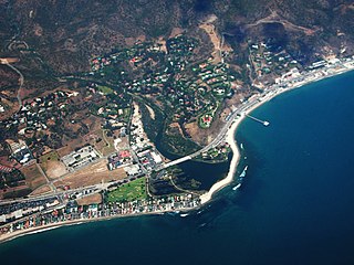
Malibu is a beach city in the Santa Monica Mountains region of Los Angeles County, California, situated about 30 miles (48 km) west of Downtown Los Angeles. It is known for its Mediterranean climate and its 21-mile (34 km) strip of the Malibu coast, incorporated in 1991 into the City of Malibu. The exclusive Malibu Colony has been historically home to Hollywood celebrities. People in the entertainment industry and other affluent residents live throughout the city, yet many residents are middle class. Most Malibu residents live from a half-mile to within a few hundred yards of Pacific Coast Highway, which traverses the city, with some residents living up to one mile away from the beach up narrow canyons. As of the 2020 census, the city population was 10,654.

Gilroy is a city in Northern California's Santa Clara County, south of Morgan Hill and north of San Benito County. Gilroy is the southernmost city in the San Francisco Bay Area, with a population of 56,766 as of the 2019 U.S. Census Projections.

Morgan Hill is a city in Santa Clara County, California, at the southern tip of Silicon Valley, in the San Francisco Bay Area. Morgan Hill is an affluent residential community, the seat of several high-tech companies, and a dining, entertainment, and recreational destination, owing to its luxury hospitality, wineries, and nature parks.
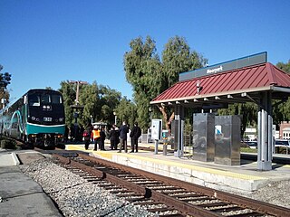
Moorpark is a city in Ventura County in Southern California. Moorpark was founded in 1900. The town grew from just over 4,000 citizens in 1980 to over 25,000 by 1990. As of 2006, Moorpark was one of the fastest-growing cities in Ventura County. The population was 34,421 at the 2010 census, up from 31,415 at the 2000 census.

West Hills is a suburban / residential community in the western San Fernando Valley region of the City of Los Angeles, California. The percentage of residents aged 35 and older is among the highest in Los Angeles County.
Porter Ranch is a suburban neighborhood in the northwest San Fernando Valley region of the City of Los Angeles, California.

Henry W. Coe State Park is a state park of California, United States, preserving a vast tract of the Diablo Range. The park is located closest to the city of Morgan Hill, and is located in both Santa Clara and Stanislaus counties. The park contains over 87,000 acres (35,000 ha), making it the largest state park in northern California, and the second-largest in the state. Managed within its boundaries is a designated wilderness area of about 22,000 acres (8,900 ha). This is officially known as the Henry W. Coe State Wilderness, but locally as the Orestimba Wilderness. The 89,164-acre (36,083 ha) park was established in 1959.

Coyote Hills Regional Park is a regional park encompassing nearly 978 acres of land and administered by the East Bay Regional Park District. The park, which was dedicated to public use in 1967, is located in Fremont, California, USA, on the southeast shore of the San Francisco Bay. The Coyote Hills themselves are a small range of hills at the edge of the bay; though not reaching any great height, they afford tremendous views of the bay, three of the trans-bay bridges, the cities of San Francisco and Oakland, the Peninsula Range of the Santa Cruz Mountains and Mount Tamalpais. In addition to the hills themselves, the park encloses a substantial area of wetlands.

The Santa Monica Mountains National Recreation Area is a United States national recreation area containing many individual parks and open space preserves, located primarily in the Santa Monica Mountains of Southern California. The SMMNRA is in the greater Los Angeles region, with two thirds of the parklands in northwest Los Angeles County, and the remaining third, including a Simi Hills extension, in southeastern Ventura County.
Santa Clarita is a city in northwestern Los Angeles County in the U.S. state of California. With a 2020 census population of 228,673, it is the third-largest city by population in Los Angeles County, the 17th-largest in California, and the 99th-largest city in the United States. It is located about 30 miles (48 km) northwest of downtown Los Angeles, and occupies 70.75 square miles (183.2 km2) of land in the Santa Clarita Valley, along the Santa Clara River. It is a notable example of a U.S. edge city, satellite city, or boomburb.

The Witch Creek Fire, also known as the Witch Fire and the Witch-Guejito–Poomacha Complex Fire, was the second-largest wildfire of the 2007 California wildfire season, and the largest one of the October 2007 California wildfires. Although the Witch Creek Fire was individually smaller than the Zaca Fire of 2007, burning 197,990 acres (801 km2) acres alone, after merging with the Poomacha and McCoy Fires, the Witch–Guejito–Poomacha Complex Fire had a total burn area of 247,800 acres (1,003 km2), surpassing the Zaca Fire to become the largest complex fire of 2007. Initially igniting in Witch Creek Canyon, near Santa Ysabel, the Witch Creek Fire rapidly spread westward, fanned by powerful Santa Ana winds, and consumed large portions of San Diego County. On October 25, the Witch Fire merged with the Poomacha Fire to the north, near Palomar Mountain, before also merging with the smaller McCoy Fire on the next day. The Witch–Poomacha Complex Fire was the second-to-last fire of the 2007 October wildfires to be extinguished, with the Poomacha Fire being contained on November 13. The last remaining fire, the Harris Fire, was fully extinguished on November 16. During its duration, 80–100 feet-high flames were reported by fire officials in the Witch Fire, and the Witch Fire exhibited the characteristics of a firestorm at its height.

Simi Valley is a city in the valley of the same name in the southeast region of Ventura County, California, United States. Simi Valley is 40 miles (65 km) from Downtown Los Angeles, making it part of the Greater Los Angeles Area. The city sits next to Thousand Oaks, Moorpark, and Chatsworth. As of the 2020 U.S. Census the population was 126,356, up from 124,243 in 2010. The city of Simi Valley is surrounded by the Santa Susana Mountains and the Simi Hills, west of the San Fernando Valley, and northeast of the Conejo Valley. It grew as a commuter bedroom community for the cities in the Los Angeles area, and the San Fernando Valley when a freeway was built over the Santa Susana Pass.
North Metro TV, also known as "NMTV", is a community and Public, educational, and government access (PEG) television station servicing the cities of Blaine, Centerville, Circle Pines, Ham Lake, Lexington, Lino Lakes, and Spring Lake Park in the Twin Cities Northern Metro area in Minnesota.

Santa Clara County, officially the County of Santa Clara, is the sixth-most populous county in the U.S. state of California, with a population of 1,936,259, as of the 2020 census. Santa Clara County and neighboring San Benito County together form the U.S. Census Bureau's San Jose-Sunnyvale-Santa Clara metropolitan statistical area, which is part of the larger San Jose-San Francisco-Oakland combined statistical area. Santa Clara is the most populous county in the San Francisco Bay Area and in Northern California. The county seat and largest city is San Jose, the 10th-most populous city in the United States, California's third-most populous city and the most populous city in the San Francisco Bay Area.

The Dennis DeBell Uvas Creek Park Preserve is a 125-acre greenbelt preserve operated by the City of Gilroy in southwest Santa Clara County, California. The Uvas Creek, which meanders through the center of the preserve, is its defining characteristic. The preserve is bordered by Uvas Creek Levee on the north, and by Christmas Hill Park on the south. A paved trail runs for approximately 2 miles along the boundary of the preserve, and can be used for jogging, hiking or bicycling.
The Bernardo Fire was a wildfire that occurred during the May 2014 San Diego County wildfire outbreak. The Bernardo fire was the second of the May 2014 wildfires in San Diego County, and the first of the swarm of wildfires that ignited in mid-May, following dry weather and Santa Ana conditions. The fire ignited in 4S Ranch in San Diego County, on May 13, near Del Norte High School, and eventually spread southward and westward, burning 1,548 acres (6 km2) of land. The Bernardo Fire was extinguished on May 17, without causing any significant property losses.

Santa Clara County Parks and Recreation Department, sometimes referred to as Santa Clara County Parks Department or Santa Clara County Parks, is a government department in Santa Clara County, California. The department manages 29 parks with a total area over 52,000 acres (21,000 ha).

The Crews Fire was a wildfire that burned east of the city of Gilroy in Santa Clara County, California in the United States. The fire started on July 5, 2020. It burned 5,513 acres (2,231 ha) and was extinguished on July 13, 2020. Burning approximately three miles east of Highway 101, the fire caused the evacuation approximately 20 homes and 70 residents. One structure was destroyed, one was damaged, and one firefighter was injured. It threatened 30 structures and farm and ranch lands in southeast Gilroy in the San Juan Valley. Mandatory evacuations were ordered on July 5, and they were lifted on July 8th.

