Chuar Butte

Last updated
Chuar Butte
Chuar Butte, east aspect.jpg
East aspect
Highest point
Elevation 6,500 ft (2,000 m) [1]
Prominence 1,513 ft (461 m) [1]
Parent peak Gunther Castle (7,199 ft) [1]
Isolation 2.95 mi (4.75 km) [1]
Coordinates 36°11′45″N111°49′29″W / 36.1958779°N 111.8248042°W / 36.1958779; -111.8248042 Coordinates: 36°11′45″N111°49′29″W / 36.1958779°N 111.8248042°W / 36.1958779; -111.8248042 [2]
Geography
USA Arizona relief location map.svg
Red triangle with thick white border.svg
Chuar Butte
Location in Arizona
Usa edcp relief location map.png
Red triangle with thick white border.svg
Chuar Butte
Chuar Butte (the United States)
Location Grand Canyon National Park
Coconino County, Arizona, US
Parent range Kaibab Plateau
Colorado Plateau
Topo map USGS Cape Solitude
Geology
Type of rock sandstone, siltstone, limestone
Climbing
Easiest route class 5.2 climbing [1]

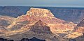
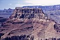
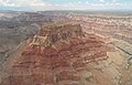
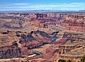
Chuar Butte is a prominent 6,500-foot-elevation (2,000-meter) summit located in the Grand Canyon, in Coconino County of northern Arizona, US. [2] It is situated 1.5 miles northwest of Cape Solitude on the canyon's East Rim, three miles southeast of Gunther Castle, and immediately west of the confluence of the Colorado River and Little Colorado River. This position also places it where Marble Canyon ends, and the Grand Canyon begins. Topographic relief is significant as it rises nearly 3,800 feet (1,200 meters) above the river in less than one mile. According to the Köppen climate classification system, Chuar Butte is located in a cold semi-arid climate zone. [3]

Contents

History

Chuar Butte was named by John Wesley Powell for Chuarrumpeak, or Chuar-ru-um-pik, a young Kaibabits tribal chief who assisted Powell and was known among early settlers as "Chuar" for short. [2] [4] [5] [6] A variant name for this butte is Chuarooum Peak. [2] This feature's name was officially adopted in 1906 by the U.S. Board on Geographic Names. [2]

Chuar Butte and adjacent Temple Butte are the historical site of wreckage from the 1956 Grand Canyon mid-air collision, in which two commercial airliners collided, resulting in the deaths of all 128 on board both planes. This disaster was a catalyst that forced the government to overhaul airline regulation and to establish the Federal Aviation Administration. The site was designated a National Historic Landmark on April 22, 2014, and is in a remote area of the canyon that is only accessible to hikers.

Geology

The top of Chuar Butte is composed of Permian Kaibab Limestone, which overlays cream-colored, cliff-forming, Permian Coconino Sandstone. [7] The sandstone, which is the third-youngest of the strata in the Grand Canyon, was deposited 265 million years ago as sand dunes. Below the Coconino Sandstone is reddish, slope-forming, Permian Hermit Formation, which in turn overlays the Pennsylvanian-Permian Supai Group. Further down are strata of Mississippian Redwall Limestone, and finally Cambrian Tonto Group at river level. The Butte Fault is on the west side of Chuar Butte. Uplift along the fault has lifted the Neoproterozoic Chuar Group 3,000 feet relative to the limestone layer, exposing mudstone of the Chuar Group. [8]

See also

Related Research Articles

<span class="mw-page-title-main">Temple Butte</span> Landform in the Grand Canyon, Arizona

Temple Butte, in the Grand Canyon, Arizona, US is a prominence below the East Rim. The butte lies on the west bank of the south-flowing Colorado River. The outfall from the Little Colorado River, draining from the Painted Desert to the east and southeast, is about 2-mi upstream.

<span class="mw-page-title-main">Zoroaster Temple</span> Landform in Coconino County, Arizona

Zoroaster Temple is a 7,123-foot-elevation (2,171-meter) summit located in the Grand Canyon, in Coconino County of Arizona, USA. It is situated 5.5 miles (8.9 km) northeast of the Yavapai Point overlook on the canyon's South Rim, from which it can be seen towering over 4,600 feet above the Colorado River and Granite Gorge. Its nearest higher neighbor is Brahma Temple, less than one mile to the north-northeast. Zoroaster Temple is named for Zoroaster, an ancient Iranian prophet. This name was used by George Wharton James and Clarence Dutton. Dutton began the tradition of naming geographical features in the Grand Canyon after mythological deities. This geographical feature's name was officially adopted in 1906 by the U.S. Board on Geographic Names.

<span class="mw-page-title-main">Brahma Temple (Grand Canyon)</span> Landform in the Grand Canyon, Arizona

Brahma Temple is a 7,551-foot-elevation summit located in the Grand Canyon, in Coconino County of Arizona, US. It is situated six miles (9.7 km) north-northeast of the Yavapai Point overlook on the canyon's South Rim, and 4.5 miles south of the North Rim's Bright Angel Point. It towers 5,000 feet above Phantom Ranch in Bright Angel Canyon. Its nearest higher neighbor is Oza Butte, four miles to the north-northwest. Other neighbors include Zoroaster Temple one mile to the south, and Deva Temple, 1.5 miles to the north. Brahma Temple is named for Brahma, the Hindu creator of the universe. This name was applied by Clarence Dutton who began the tradition of naming geographical features in the Grand Canyon after mythological deities. This geographical feature's name was officially adopted in 1906 by the U.S. Board on Geographic Names.

<span class="mw-page-title-main">Vishnu Temple (Grand Canyon)</span> Landform in the Grand Canyon, Arizona

Vishnu Temple is a 7,533-foot-elevation (2,296-meter) summit located in the Grand Canyon, in Coconino County of Arizona, US.

<span class="mw-page-title-main">Wotans Throne</span> Landform in the Grand Canyon, Arizona

Wotans Throne is a 7,721-foot-elevation (2,353-meter) summit located in the Grand Canyon, in Coconino County of Arizona, US. It is situated one mile immediately southwest of the Cape Royal overlook on the canyon's North Rim, 1.7 mile west-southwest of Freya Castle, two miles west-northwest of Vishnu Temple, and five miles east of Zoroaster Temple. It rises 5,200 feet above the Colorado River.

<span class="mw-page-title-main">Shiva Temple (Grand Canyon)</span> Landform in the Grand Canyon, Arizona

Shiva Temple is a 7,646-foot-elevation (2,331-meter) summit located in the Grand Canyon, in Coconino County of Arizona, US. It is situated six miles north of Hopi Point overlook of the canyon's South Rim, about 2.5 miles southwest of North Rim's Tiyo Point, and two miles northwest of Isis Temple, where it towers 5,200 feet above the Colorado River. Shiva Temple is named for Shiva, the Hindu deity, destroyer of the universe. This name was applied by Clarence Dutton who began the tradition of naming geographical features in the Grand Canyon after mythological deities. Dutton believed Shiva Temple was the largest, grandest, and most majestic of the Grand Canyon buttes, with a broad, level, forested top. This mountain's name was officially adopted in 1906 by the U.S. Board on Geographic Names.

<span class="mw-page-title-main">Angels Gate</span> Landform in the Grand Canyon, Arizona

Angels Gate is a 6,761-foot (2,061 m)-elevation summit located in the Grand Canyon, in Coconino County of Arizona, United States. It is situated seven miles (11 km) due north of the Grandview Point overlook on the canyon's South Rim, three miles (4.8 km) west of Vishnu Temple, and three point five miles (5.6 km) southeast of Zoroaster Temple. Topographic relief is significant as it rises over 4,200 feet (1,300 m) above the Colorado River in three miles. Angels Gate is the place in Paiute mythology where the gods would return to earth by descending from the shadow world above. George Wharton James applied the "Angel Gate" name to this geographical feature in his book, In & Around the Grand Canyon, in 1900. This feature's name was officially adopted in 1906 by the U.S. Board on Geographic Names. Angels Gate has four peaks composed of Coconino Sandstone. The main highest summit and three spires are known as "Snoopy and his Doghouse" for a resemblance to Snoopy, and the first ascent was made April 1972 by Chuck Graf and Dave Ganci. According to the Köppen climate classification system, Angels Gate is located in a cold semi-arid climate zone.

<span class="mw-page-title-main">Buddha Temple (Grand Canyon)</span> Landform in the Grand Canyon, Arizona

Buddha Temple is a 7,212-foot-elevation (2,198-meter) summit located in the Grand Canyon, in Coconino County of northern Arizona, in the Southwestern United States. It is situated 6.5 miles (10.5 km) due north of the Mather Point overlook on the canyon's South Rim, and four miles southwest of the North Rim's Bright Angel Point. Topographic relief is significant as it rises over 3,800 feet in two miles above Bright Angel Canyon to the east, and 3,000 feet in less than one mile above Haunted Canyon to the immediate west. Its neighbors include Manu Temple 1.5 miles (2.4 km) to the northeast, Isis Temple 2.3 miles to the southwest, Zoroaster Temple 3.8 miles to the southeast, and Deva Temple, 3.5 miles to the east. Buddha Temple was named by Henry Gannett, a geographer for Clarence Dutton, in following Dutton's practice of naming features in the Grand Canyon after mythological deities, in this case Buddha. This geographical feature's name was officially adopted in 1906 by the U.S. Board on Geographic Names. The first ascent of this butte was made in 1973 by Bruce Grubbs, Chauncey Parker, and Mark Brown via the Northwest Arete. According to the Köppen climate classification system, Buddha Temple is located in a Cold semi-arid climate zone.

<span class="mw-page-title-main">Coronado Butte</span> Landform in the Grand Canyon, Arizona

Coronado Butte is a 7,162-foot (2,183 m)-elevation summit located in the Grand Canyon, in Coconino County of Arizona, United States. It is situated one mile (1.6 km) west of the Moran Point overlook on the canyon's South Rim, and one mile northeast of Sinking Ship, its nearest higher neighbor. Topographic relief is significant as this butte rises 4,600 feet (1,400 m) above the Colorado River in 2.5 miles (4.0 km). Coronado Butte is named for Francisco Vázquez de Coronado (1510–1554), the explorer whose 1540 expedition was the first European sighting of the Grand Canyon, among other landmarks. This geographical feature's name was officially adopted in 1906 by the U.S. Board on Geographic Names. The first ascent was made by John Hance and tourist prior to 1900, in the 1890s. According to the Köppen climate classification system, Coronado Butte is located in a cold semi-arid climate zone.

<span class="mw-page-title-main">Apollo Temple</span> Landform in the Grand Canyon, Arizona

Apollo Temple is a 6,252-foot-elevation (1,906-meter) summit located in the Grand Canyon, in Coconino County of northern Arizona, US. It is situated four miles due east of Cape Royal on the canyon's North Rim, four miles northeast of Vishnu Temple, and a half-mile south-southeast of Venus Temple, which is the nearest higher neighbor. Topographic relief is significant as it rises over 3,600 feet above the Colorado River in less than two miles.

<span class="mw-page-title-main">Comanche Point (Grand Canyon)</span> Landform in the Grand Canyon, Arizona

Comanche Point is a 7,073-foot-elevation (2,156-meter) summit located in the Grand Canyon, in Coconino County of northern Arizona, US. Part of the Palisades of the Desert, Comanche Point is the high point on the canyon's less-visited East Rim, and is four miles north-northeast of Desert View Point, its nearest higher neighbor. Topographic relief is significant as it towers 4,400 feet above the Colorado River in 1.5 mile. Comanche Point was named in 1900 by George Wharton James for the Comanche, a Native-American nation from the Great Plains, in keeping with a practice of naming the points on the canyon's South Rim for Native American nations. This geographical feature's name was officially adopted in 1906 by the U.S. Board on Geographic Names. According to the Köppen climate classification system, Comanche Point is located in a Cold semi-arid climate zone. On September 27, 1994, the tabloid Weekly World News ran an outlandish cover story that wreckage of a 4000-year-old UFO had been found in limestone rubble near the base of Comanche Point.

<span class="mw-page-title-main">Gunther Castle</span> Landform in the Grand Canyon, Arizona

Gunther Castle is a 7,199-foot-elevation (2,194-meter) summit located in the Grand Canyon, in Coconino County of northern Arizona, US. It is situated three miles northwest of Chuar Butte, between Kwagunt Valley to the north, and Chuar Valley to the south. Topographic relief is significant as it rises nearly 4,500 feet above the Colorado River in three miles.

<span class="mw-page-title-main">Steamboat Mountain (Coconino County, Arizona)</span> Landform in the Grand Canyon, Arizona

Steamboat Mountain is a 7,410-foot-elevation (2,260-meter) summit located in the Grand Canyon, in Coconino County of northern Arizona, US. It is situated four miles northwest of Holy Grail Temple, and 2.5 miles west-southwest of Timp Point on the North Rim. George Wharton James described it as a "majestic butte", nearly encircled by Galloway and Saddle Canyons. Topographic relief is significant as it rises over 5,400 feet above the Colorado River in three miles. According to the Köppen climate classification system, Steamboat Mountain is located in a Cold semi-arid climate zone, with precipitation runoff draining west to the Colorado River via Tapeats Creek and Stone Creek. This feature's name was officially adopted in 1932 by the U.S. Board on Geographic Names.

<span class="mw-page-title-main">Jupiter Temple</span> Landform in the Grand Canyon, Arizona

Jupiter Temple is a 7,084-foot (2,159 m)-elevation summit located in the Grand Canyon, in Coconino County of northern Arizona, United States. It is situated one mile (1.6 km) southeast of Cape Final on the canyon's North Rim, one point five miles (2.4 km) north-northwest of Apollo Temple, and three miles (4.8 km) northeast of Freya Castle, which is the nearest higher peak. Topographic relief is significant as it rises 4,400 feet (1,300 m) above the Colorado River in less than four miles (6.4 km).

<span class="mw-page-title-main">Diana Temple (Grand Canyon)</span> Landform in the Grand Canyon, Arizona

Diana Temple is a 6,683-foot-elevation (2,037-meter) summit located in the Grand Canyon, in Coconino County of northern Arizona, US. It is situated nine miles northwest of Grand Canyon Village, and immediately northeast of Mescalero Point. Pollux Temple is one mile northwest, Marsh Butte one mile east-northeast, and Vesta Temple is one mile south. Topographic relief is significant as Diana Temple rises nearly 4,300 feet above the Colorado River in less than two miles. Diana Temple is named for Diana, the goddess of the hunt and the moon according to Roman mythology. Clarence Dutton began the practice of naming geographical features in the Grand Canyon after mythological deities. The U.S. Geological Survey applied the name, and this geographical feature's name was officially adopted in 1908 by the U.S. Board on Geographic Names. In the early 1900s this mesa was sometimes called "No Mans Land". According to the Köppen climate classification system, Diana Temple is located in a Cold semi-arid climate zone.

<span class="mw-page-title-main">Hancock Butte (Arizona)</span> Landform in the Grand Canyon, Arizona

Hancock Butte is a 7,683-foot-elevation summit located in the Grand Canyon, in Coconino County of northern Arizona, US. It is situated one mile south of the Point Imperial viewpoint on the canyon's North Rim, where it towers 3,700 feet above Nankoweap Canyon. Its nearest higher neighbor is Mount Hayden, one mile to the north-northeast, Kibbey Butte is one mile to the south-southwest, and Brady Peak is 1.5 mile to the southeast. Hancock Butte is named after William A. Hancock (1831–1902), a pioneer and politician of the Arizona Territory known for performing the survey work required to create the town of Phoenix and erecting the first building there in 1870. This geographical feature's name was officially adopted in 1932 by the U.S. Board on Geographic Names. According to the Köppen climate classification system, Hancock Butte is located in a Cold semi-arid climate zone.

<span class="mw-page-title-main">Butchart Butte</span> Landform in the Grand Canyon, Arizona

Butchart Butte is a 7,602-foot (2,317 m)-elevation summit located in the Grand Canyon, in Coconino County of northern Arizona, United States. It is situated on the North Rim, midway between Gunther Castle and Siegfried Pyre, and between the Chuar and Kwagunt Valleys. Topographic relief is significant as it rises 4,900 feet (1,500 m) above the Colorado River in five miles.

<span class="mw-page-title-main">Manu Temple</span> Landform in the Grand Canyon, Arizona

Manu Temple is a 7,184-foot-elevation (2,190-meter) summit located in the Grand Canyon, in Coconino County of northern Arizona, United States. It is situated one mile south of the North Rim's Widforss Point, 1.5 miles (2.4 km) northeast of parent Buddha Temple, and three miles southwest of the North Rim's Bright Angel Point. Topographic relief is significant as it rises nearly 3,600 feet in two miles above Bright Angel Canyon to the east, and 2,200 feet in less than one mile above Haunted Canyon to the immediate west. Its neighbors include Brahma Temple and Deva Temple to the east on the opposite side of Bright Angel Canyon. From the South Rim of the canyon it may be difficult to discern Manu Temple from the walls of the Kaibab Plateau one mile behind it, but when the lighting and atmosphere are favorable, this butte of great proportions can be seen clearly defined.

<span class="mw-page-title-main">Vesta Temple</span> Landform in the Grand Canyon, Arizona

Vesta Temple is a 6,299-foot-elevation (1,920-meter) summit located in the Grand Canyon, in Coconino County of northern Arizona, US. It is situated eight miles west-northwest of Grand Canyon Village, and immediately northeast of Mimbreno Point. Marsh Butte is one mile northeast, Eremita Mesa immediately southeast, and nearest higher neighbor Diana Temple is one mile north. Topographic relief is significant as Vesta Temple rises 3,900 feet above the Colorado River in 2.5 miles. Vesta Temple is named for Vesta, the goddess of the hearth, home, and family according to Roman mythology. Clarence Dutton began the practice of naming geographical features in the Grand Canyon after mythological deities. This geographical feature's name was officially adopted in 1908 by the U.S. Board on Geographic Names. According to the Köppen climate classification system, Vesta Temple is located in a Cold semi-arid climate zone.

<span class="mw-page-title-main">Sinking Ship (Grand Canyon)</span> Landform in the Grand Canyon, Arizona

Sinking Ship is a 7,344-foot (2,238 m) elevation summit located in the Grand Canyon, in Coconino County of northern Arizona, United States. This butte is situated 1.7 miles (2.7 km) southeast of the Grandview Point overlook on the canyon's South Rim, and 1.25 miles (2.01 km) southwest of Coronado Butte. Topographic relief is significant as it rises 4,800 feet (1,500 m) above the Colorado River in 4 miles (6.4 km). According to the Köppen climate classification system, Sinking Ship is located in a cold semi-arid climate zone.

References

  1. 1 2 3 4 5 "Chuar Butte – 6,500' AZ". Lists of John. Retrieved January 2, 2021.
  2. 1 2 3 4 5 "Chuar Butte". Geographic Names Information System . United States Geological Survey, United States Department of the Interior . Retrieved 2021-01-02.
  3. Peel, M. C.; Finlayson, B. L.; McMahon, T. A. (2007). "Updated world map of the Köppen−Geiger climate classification". Hydrol. Earth Syst. Sci. 11. ISSN   1027-5606.
  4. William Culp Darrah, Powell of the Colorado, 1951, Princeton University Press, page 155.
  5. Gregory McNamee, Grand Canyon Place Names, 1997, Mountaineers Publisher, ISBN   9780898865332, page 35.
  6. Powell’s Surveyors at Pipe Spring NPS.gov
  7. N.H. Darton, Story of the Grand Canyon of Arizona, 1917, page 62.
  8. William Kenneth Hamblin, Anatomy of the Grand Canyon: Panoramas of the Canyon's Geology, 2008, Grand Canyon Association Publisher, ISBN   9781934656013, page 70.