
The Financial District of Lower Manhattan, also known as FiDi, is a neighborhood located on the southern tip of Manhattan island in New York City. It is bounded by the West Side Highway on the west, Chambers Street and City Hall Park on the north, Brooklyn Bridge on the northeast, the East River to the southeast, and South Ferry and the Battery on the south.

Fishtown is a neighborhood in the River Wards section of Philadelphia, Pennsylvania, United States. Located northeast of Center City, its borders are somewhat disputed today due to many factors, but are roughly defined by the triangle created by the Delaware River, Frankford Avenue, and York Street. Some newer residents expand the area to Lehigh Avenue, while some older residents shrink the area to Norris Street. It is served by the Market–Frankford Line rapid transit subway/elevated line of the SEPTA system. Fishtown is a largely working class Irish Catholic neighborhood, but it has recently seen a large influx of young urban professionals and gentrification.

Over-the-Rhine is a neighborhood in Cincinnati, Ohio, United States. Historically, Over-the-Rhine has been a working-class neighborhood. It is among the largest, most intact urban historic districts in the United States.

Old City is a neighborhood in Center City, Philadelphia near the Delaware River waterfront. It is now best known for historic sites such as Independence Hall.
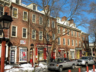
Society Hill is a historic neighborhood in Center City Philadelphia, Pennsylvania with a population of 6,215 as of the 2010 United States Census. Settled in the early 1680s, Society Hill is one of the oldest residential neighborhoods in Philadelphia. After urban decay developed between the late 19th and early 20th centuries, an urban renewal program began in the 1950s, restoring the area and its many historic buildings. Society Hill has since become one of the most expensive neighborhoods with the highest average income and second highest real estate values in Philadelphia. Society Hill's historic colonial architecture, along with planning and restoration efforts, led the American Planning Association to designate it, in 2008, as one of the great American neighborhoods and a good example of sustainable urban living.
Christiana High School (CHS) is a public high school in unincorporated New Castle County, Delaware and has a Newark postal address. It is a part of the Christiana School District. CHS serves a portion of Wilmington including the Shipley Run and West 9th Street historic districts and in the suburbs it serves parts of Brookside and Bear.

This list is intended to be a complete compilation of properties and districts listed on the National Register of Historic Places in Rensselaer County, New York, United States. Seven of the properties are further designated National Historic Landmarks.
The neighborhood of Irvington, named after Washington Irving, includes Irvington Historic District, a historic district in Indianapolis, Indiana. The historic district is a 545-acre (221 ha) area that was listed on the National Register of Historic Places in 1987. That year, the district included 2,373 contributing buildings, 5 other contributing structures, and 2 contributing sites.

The Schenley Farms Historic District, also referred to as the Schenley Farms–Oakland Civic District, is a historic district listed on the National Register of Historic Places that is located in the Oakland section of Pittsburgh, Pennsylvania, United States.

This is a list of the National Register of Historic Places listings in Dakota County, Minnesota. It is intended to be a complete list of the properties and districts on the National Register of Historic Places in Dakota County, Minnesota, United States. Dakota County is located in the southeastern part of the U.S. state of Minnesota, bounded on the northeast side by the Upper Mississippi River and on the northwest by the Minnesota River. The locations of National Register properties and districts for which the latitude and longitude coordinates are included below, may be seen in an online map.

This list is of the properties and historic districts which are designated on the National Register of Historic Places or that were formerly so designated, in Hennepin County, Minnesota; there are 186 entries as of October 2021. A significant number of these properties are a result of the establishment of Fort Snelling, the development of water power at Saint Anthony Falls, and the thriving city of Minneapolis that developed around the falls. Many historic sites outside the Minneapolis city limits are associated with pioneers who established missions, farms, and schools in areas that are now suburbs in that metropolitan area.

This is a complete list of National Register of Historic Places listings in Ramsey County, Minnesota. It is intended to be a complete list of the properties and districts on the National Register of Historic Places in Ramsey County, Minnesota, United States. The locations of National Register properties and districts for which the latitude and longitude coordinates are included below, may be seen in an online map.

This is a list of the National Register of Historic Places listings in Saint Louis County, Minnesota. It is intended to be a complete list of the properties and districts on the National Register of Historic Places in Saint Louis County, Minnesota, United States. The locations of National Register properties and districts for which the latitude and longitude coordinates are included below, may be seen in an online map.
The Central Troy Historic District is an irregularly shaped, 96-acre (39 ha) area of downtown Troy, New York, United States. It has been described as "one of the most perfectly preserved 19th-century downtowns in the [country]" with nearly 700 properties in a variety of architectural styles from the early 19th to mid-20th centuries. These include most of Russell Sage College, one of two privately owned urban parks in New York, and two National Historic Landmarks. Visitors ranging from the Duke de la Rochefoucauld to Philip Johnson have praised aspects of it. Martin Scorsese used parts of downtown Troy as a stand-in for 19th-century Manhattan in The Age of Innocence.

The Downtown Albany Historic District is a 19-block, 66.6-acre (27.0 ha) area of Albany, New York, United States, centered on the junction of State and North and South Pearl streets. It is the oldest settled area of the city, originally planned and settled in the 17th century, and the nucleus of its later development and expansion. In 1980 it was designated a historic district by the city and then listed on the National Register of Historic Places.

There are 74 properties listed on the National Register of Historic Places in Albany, New York, United States. Six are additionally designated as National Historic Landmarks (NHLs), the most of any city in the state after New York City. Another 14 are historic districts, for which 20 of the listings are also contributing properties. Two properties, both buildings, that had been listed in the past but have since been demolished have been delisted; one building that is also no longer extant remains listed.
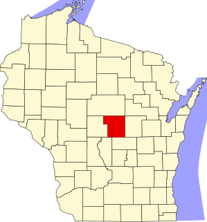
This is a list of the National Register of Historic Places listings in Portage County, Wisconsin. It is intended to provide a comprehensive listing of entries in the National Register of Historic Places that are located in Portage County, Wisconsin. The locations of National Register properties for which the latitude and longitude coordinates are included below may be seen in a map.

Delaware Avenue Historic District is a national historic district located at Wilmington, New Castle County, Delaware. It encompasses 180 contributing buildings and 1 contributing structure developed in the late-19th and early-20th centuries. The district is primarily residential and includes a variety of Victorian-era mansions and large dwellings in a variety of popular architectural styles including Italianate, Queen Anne, Colonial Revival, Classical Revival, and American Four Square The houses are detached or semi-detached and are primarily three stories in height with extensive wings to the rear. The district also includes 20th century apartment complexes. Also located in the district is the St. Stephen's Lutheran Church and the Sailors and Soldiers Monument. The separately listed Howard Pyle Studios are also located in the district.

West 9th Street Commercial Historic District is a national historic district located at Wilmington, New Castle County, Delaware. It encompasses 28 contributing buildings in a commercial area of Wilmington developed in the early 20th century. The district includes representative examples of the Italianate and Colonial Revival styles

Shipley Run Historic District is a national historic district located at Wilmington, New Castle County, Delaware. It encompasses 408 contributing buildings in a residential area located west of the Wilmington central business district. It was developed in the mid- to late-19th century and primarily consists of single-family, attached and semi-detached rowhouse dwellings. They are in a variety of popular Late Victorian architectural styles including Second Empire, Queen Anne, Italianate, and Stick style.


