The Mentawai Islands Regency are a chain of about seventy islands and islets approximately 150 kilometres off the western coast of Sumatra in Indonesia. They cover 6,033.76 km2 and had a population of 76,173 at the 2010 Census and 87,623 at the 2020 Census. Siberut at 3,838.25 square kilometres is the largest of the islands. The other major islands are Sipura, North Pagai, and South Pagai. The islands lie off the Sumatran coast, across the Mentawai Strait. The indigenous inhabitants of the islands are known as the Mentawai people. The Mentawai Islands have become a noted destination for surfing, with over 40 boats offering surf charters to international guests.

Garut Regency is a Regency in the West Java province of Indonesia. It covers an area of 3,065.19 km2 (1,186.91 mi2). Geographically, it lies between 6°57′34″ – 7°44′57″ South latitude and 107°24′34″ – 108°7′34″ East longitude. The population at the 2010 census was 2,404,121, and at the 2020 census was 2,585,607; the official estimate as at mid 2021 was 2,604,787. South Tarogong is the regency seat.

Simeulue Regency is a regency in the Aceh special region of Indonesia. It occupies the whole island of Simeulue, 150 km off the west coast of Sumatra, with an area of 1,838.09 square kilometres. It had a population of 80,674 at the 2010 census and 92,865 at the 2020 census; the official estimate as at mid 2022 was 94,876.

Cianjur Regency is a regency (kabupaten) of West Java, Indonesia. The area of the regency is 3,614.35 km2 and its population at the 2010 Census was 2,171,281; the 2020 Census produced a total of 2,477,560 and the official estimate as at mid 2022 was 2,542,793. The town of Cianjur is its capital. Northern parts of the regency form a valley, and are far more densely populated than southern regions. As such, a portion of the northern valley was briefly included in a definition of Greater Jakarta called Jabodetabekjur.
Porong is a district in Sidoarjo Regency, East Java, Indonesia. It has a population of 68,243 (2018). Located about 14 kilometres (8.7 mi) south of the regency seat, it bordered by Krembung in the west, Pasuruan Regency in the south, Tanggulangin in the north.

Bangli Regency is the one and only landlocked regency (kabupaten) of Bali, Indonesia. It covers an area of 520.81 km2 and had a population of 215,353 at the 2010 Census and 258,721 at the 2020 Census. Its regency seat is the town of Bangli.

Buleleng is a regency (kabupaten) of Bali, Indonesia. It has an area of 1,365.88 km2 and population of 624,125 at the 2010 census and 791,910 at the 2020 census. Its regency seat is at the town of Singaraja.

Belu Regency is a regency in East Nusa Tenggara province of Indonesia. Situated on the north of Timor island, it adjoins the separate nation of East Timor to the east. Established on 20 December 1958, Belu Regency has its seat (capital) in the large town of Atambua.
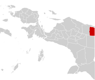
Keerom Regency is one of the regencies (kabupaten) in the Papua Province of Indonesia. It was formed from the eastern districts then within Jayapura Regency with effect from 12 November 2002. It covers an area of 9,365 km2, and had a population of 48,536 at the 2010 Census and 61,623 at the 2020 Census; the official estimate as at mid 2021 was 62,157. The regency's administrative centre is at Waris. It borders Green River Rural LLG and Amanab Rural LLG of Sandaun Province, Papua New Guinea.

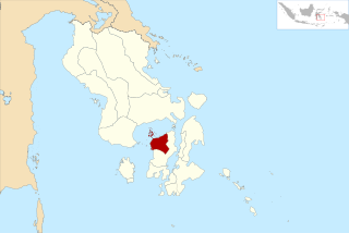
West Sumbawa Regency is a Regency (Kabupaten) of the Indonesian Province of West Nusa Tenggara. It is located on the island of Sumbawa and has an area of 1,742.27 km2. The regency was created on 18 December 2003 from what were at that time the westernmost five districts (kecamatan) of Sumbawa Regency. The population at the 2010 Census was 114,754, and at the 2020 Census was 145,798 - comprising 73,687 males and 72,111 females; the official estimate as at mid 2021 was 148,458. The capital is the town of Taliwang.
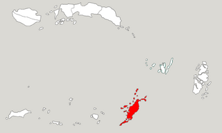
Tanimbar Islands Regency is a regency of Maluku province, Indonesia, consisting primarily of the Tanimbar Islands. The Regency covers a land area of 10,102 km2, and it had a population of 105,341 at the 2010 Census and 123,572 at the 2020 Census; the official estimate as at mid 2022 was 124,787. The principal town and administrative centre lies at Saumlaki in Tanimbar Selatan District.
Waru is a district in Sidoarjo Regency, East Java. The Purabaya bus station is located in this district.
West Muna Regency is a new regency of Southeast Sulawesi, Indonesia, established under Act No.14 of 2014, dated 23 July 2014 by separation from the Muna Regency. It covers an area of 906.28 km2, and the districts comprising it had a population of 71,632 at the 2010 Census; the 2020 Census resulted in a population of 84,590, and the official estimate as at mid 2021 was 84,777, comprising 41,888 males and 42,889 females.The administrative centre lies at Laworo.
Cipanas is a district in Lebak Regency, Banten Province, Indonesia and is the easternmost district in the regency. Cipanas is directly adjacent to Jasinga in Bogor Regency, West Java.
Subang is a district in Kuningan Regency, West Java, Indonesia.
Cipanas is a village in Cipanas, Lebak Regency, Banten, Indonesia. On 2017 the population of the village is 4.236.
The province of Southwest Papua in Indonesia is divided into regencies. The regencies are turn are divided administratively into districts, also known in Indonesian as distrik or kecamatan.