Circle of the Rhine

Last updated
Rheinkreis
Pfalz (from 1837)
Regierungsbezirk of the Kingdom of Bavaria and the Free State of Bavaria
1816–1946
Wappen Rheinpfalz.svg
Coat of arms
Capital Speyer
Area transferred
  1920Saarpfalz-Kreis to Saar Basin
History 
1 May 1816
1 May 1849
1 December 1918
 Establishment of Territory of the Saar Basin
10 January 1920
 Establishment of Rhineland-Palatinate
30 August 1946
Preceded by
Succeeded by
Flag of the Habsburg Monarchy.svg Austrian Empire
Rhineland-Palatinate Flag of Rhineland-Palatinate.svg
Saar Protectorate Flag of Saar (1947-1956).svg

The Circle of the Rhine [1] or Rhine Circle (German : Rheinkreis), sometimes the Bavarian Rheinkreis (Bayerischer Rheinkreis or Baierischer Rheinkreis), was the name given to the territory on the west bank of the Rhine from 1816 to 1837 which was one of 15 (later 8) administrative districts of the Kingdom of Bavaria. Before the French revolutionary wars (1792) most of the land had belonged to the Electoral Palatinate. At the Congress of Vienna in 1815 it was initially promised to the Austrian Empire after having been under a provisional joint Austro-Bavarian administration since 1814. However, in the Treaty of Munich (1816), Austria relinquished the territory to Bavaria.

Contents

In 1837, the Circle of the Rhine was renamed the Palatinate (Pfalz). [2] [3] It was also referred to as the Rhenish Palatinate (Rheinpfalz). [4] The territory remained Bavarian until 30 August 1946, with the exception of the area detached in 1920, which roughly corresponded to the present day Saarpfalz-Kreis . It then became part of the newly formed federal state of Rhineland-Palatinate.

Geography

Circle of the Rhine 1830 LASB K Hellwig 0836.jpg
Circle of the Rhine 1830
Speyer around 1900 in Bavarian times Speyer um 1900.jpg
Speyer around 1900 in Bavarian times
Hambach Castle, scene of the Hambach Festival in 1832 150418-Hambach-02.jpg
Hambach Castle, scene of the Hambach Festival in 1832

The Rhine Circle largely covered the same area as the present Palatinate region, which lies west of the Rhine in the south of the German state of Rhineland-Palatinate. Until 1919 it also included some territory around Homburg and Sankt Ingbert (parts of the Bezirksämter of Homburg  [ de ] and Zweibrücken  [ de ]), which was incorporated into the Territory of the Saar Basin after the end of the First World War as the districts (Landkreise) of Homburg  [ de ] and Sankt Ingbert  [ de ]. After the Second World War there were smaller losses of territory to the Saar Protectorate, especially in the area of Sankt Wendel. As part of the 1969 land reform the region designated as the Palatinate with Rhineland-Palatinate had its northern border changed somewhat; the Diocese of Speyer and the Evangelical Church of the Palatinate still exist today largely based on the historical boundaries of the Circle of the Rhine. In 1974 the two Saarland districts were dissolved and their territory largely merged into the new Saarpfalz-Kreis (Saar-Pfalz-Kreis until 1989).

History

The territory of the Rhine Circle, established in 1816, had been divided before 1792 into a total of 45 secular and ecclesiastical territories, some of which were very small. The largest were the Electoral Palatinate, the Duchy of Zweibrücken and the Prince-Bishopric of Speyer. [5] The Electoral Palatinate and the Electorate of Bavaria had had dynastic links through the House of Wittelsbach for centuries and from 1777 were ruled in a personal union under Elector Charles Theodore. The House of Palatinate-Zweibrücken was also a Wittelsbach branch.

In 1794, the Left Bank of the Rhine, including the Palatinate, was occupied by French revolutionary troops. As a result of the Treaty of Campo Formio (1797) the First French Republic annexed the region and introduced an administrative system in 1798. The subsequent Circle of the Rhine included considerable portions of the département of Mont-Tonnerre as well as smaller parts of the département of the Sarre and Bas-Rhin .

Following the defeat of Napoleon at the Battle of Leipzig in 1813 and the capture of the Left Bank of the Rhine by the Allies in January 1814, from 2 February 1814 the region was initially under the provisional authority of the General Government of the Middle Rhine, but, from 16 June that same year, it was placed under the administration of the Imperial-Royal Austrian and Royal Bavarian Joint Land Administration Commission (k. k. östreichischen und k. bairischen gemeinschaftliche Landes-Administrations-Kommission). [6]

In the main treaty agreed at the Congress of Vienna in 1815, and dated 9 June 1815, Article 51 stated that (inter alia) on the Left Bank of the Rhine the former départements of the Sarre and Mont-Tonnere, except where stated in the same treaty, were to go "with full sovereignty" and ownership rights under the overlordship of the Emperor of Austria (Herrschaft Sr. Maj. des Kaisers von Oesterreich). [7] The joint Austro-Bavarian administration was initially retained, however.

On 14 April 1816, a treaty was signed between Austria and Bavaria, in which the various territorial changes were agreed. According to Article 2 of the treaty, Emperor Francis I of Austria ceded various regions to Maximilian I of Bavaria. These included, in addition to various regions east of the Rhine, the following regions west of the Rhine: [8]

In the Département of Mont-Tonnerre (Donnerberg):
  1. the districts of Zweibrücken, Kaiserslautern and Speier; the latter with the exception of the cantons of Worms and Pfeddersheim;
  2. the canton of Kirchheim-Bolanden, in districts of Alzei.
In the SarreDépartement:
  1. the cantons of Waldmohr, Blieskastel and Kusel, the latter with the exception of several villages on the road from St. Wendel to Baumholder, which were to be compensated, by another territorial transfer, with the agreement of the assembled plenipotentiaries of the allied powers at Frankfurt.
In the Département of Bas-Rhin:
  1. the canton, town and fortress of Landau, the latter as a federal fortress in accordance with the regulations of 3 November 1815;
  2. the cantons of Bergzabern. Langenkandel and the whole part of the Département of Bas-Rhin on the left bank of the Lauter, which had been ceded in the Paris Tractat of 20 November 1815.

The effective date for these changes was stated as 1 May 1816.

In accordance with the prevailing Bavarian administrative structure, the region was given the name "Rhine Circle" (Rheinkreis) with Speyer as its capital. Of the former French administrative structure, the subdivision of the region into cantons, mayoralties and municipalities was retained.

As his first provincial governor, King Maximilian selected the Privy Councillor (Hofrat) Franz Xaver von Zwackh  [ de ], whose name is responsible for the popular Palatinate nickname for Bavarian officials, Zwockel  [ de ].

See also

Related Research Articles

<span class="mw-page-title-main">Electoral Palatinate</span> State of the Holy Roman Empire (1085–1803)

The Electoral Palatinate or the Palatinate, officially the Electorate of the Palatinate, was a constituent state of the Holy Roman Empire. The electorate had its origins under the rulership of the Counts Palatine of Lotharingia in 915; it was then restructured under the Counts Palatine of the Rhine in 1085. From 1214 until the Electoral Palatinate was merged into the Kingdom of Bavaria in 1805, the House of Wittelsbach provided the Counts Palatine or Electors. These counts palatine of the Rhine would serve as prince-electors from "time immemorial", and were noted as such in a papal letter of 1261; they were confirmed as electors by the Golden Bull of 1356.

<span class="mw-page-title-main">Palatinate (region)</span> Historical region of Germany

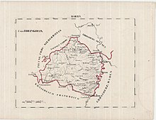
The Palatinate, or the Rhenish Palatinate (Rheinpfalz), is a historical region of Germany. Prior to World War II, it was also referred to as Rhenish Bavaria; as a state of the Holy Roman Empire, it was known as the Lower Palatinate (Unterpfalz), which designated only the western part of the Electorate of the Palatinate, as opposed to the Upper Palatinate (Oberpfalz). It occupies roughly the southernmost quarter of the German federal state of Rhineland-Palatinate (Rheinland-Pfalz), covering an area of 2,105 square miles (5,450 km2) with about 1.4 million inhabitants. Its residents are known as Palatines (Pfälzer).

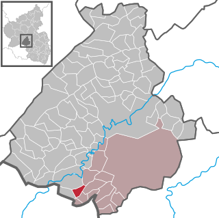
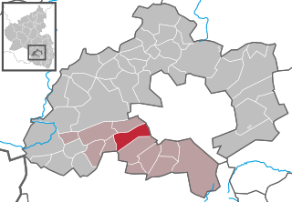
Saarpfalz (Saar-Palatinate) is a Kreis (district) in the south-east of the Saarland, Germany. Neighboring districts are Saarbrücken, Neunkirchen, Kusel, Kaiserslautern, Südwestpfalz, district-free Zweibrücken, and the French département Moselle.

<span class="mw-page-title-main">Sarre (department)</span>

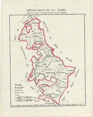
Sarre was a department in the First French Republic and First French Empire. Its territory is now part of Germany and Belgium. Named after the river Saar, it was created in 1798 in the aftermath of the Treaty of Campo Formio of 18 October 1797 which ceded the left bank of the Rhine to France.

<span class="mw-page-title-main">Homburg, Saarland</span> Town in Saarland, Germany

Homburg is a town in Saarland, Germany and the administrative seat of the Saarpfalz district. With a population of 43,029 inhabitants (2022), it is the third largest town in the state. The city offers over 30,000 workplaces. The medical department of the University of Saarland is situated here. The city is also home to the Karlsberg beer brewery. Major employers include Robert Bosch GmbH, Schaeffler Group and Michelin.

<span class="mw-page-title-main">Kingdom of Bavaria</span> 1806–1918 kingdom in Central Europe

The Kingdom of Bavaria was a German state that succeeded the former Electorate of Bavaria in 1806 and continued to exist until 1918. With the unification of Germany into the German Empire in 1871, the kingdom became a federated state of the new empire and was second in size, power, and wealth only to the leading state, the Kingdom of Prussia.

<span class="mw-page-title-main">Palatine Zweibrücken</span> Historical territory in present-day Rhineland-Palatinate, Germany

The Duchy of Palatinate-Zweibrücken was a duchy of the Holy Roman Empire with full voting rights to the Reichstag. Its capital was Zweibrücken. The reigning house, a branch of the Wittelsbach dynasty, was also the Royal House of Sweden from 1654 to 1720.

<span class="mw-page-title-main">Blieskastel</span> Town in Saarland, Germany

Blieskastel is a city in the Saarpfalz (Saar-Palatinate) district, in Saarland, Germany which is divided into villages. It is situated on the river Blies, approximately 10 kilometres southwest of Homburg (Saar), 8 km (5 mi) west of Zweibrücken, and 20 km (12 mi) east of Saarbrücken.

<span class="mw-page-title-main">Leitzweiler</span> Municipality in Rhineland-Palatinate, Germany

Leitzweiler is an Ortsgemeinde – a municipality belonging to a Verbandsgemeinde, a kind of collective municipality – in the Birkenfeld district in Rhineland-Palatinate, Germany. It belongs to the Verbandsgemeinde of Baumholder, whose seat is in the like-named town.

<span class="mw-page-title-main">Bann, Germany</span> Municipality in Rhineland-Palatinate, Germany

Bann is a municipality in the district of Kaiserslautern, in Rhineland-Palatinate, western Germany. Located in the Steinalb valley with the Palatinate Forest bordering it to the east.

<span class="mw-page-title-main">Linden, Kaiserslautern</span> Municipality in Rhineland-Palatinate, Germany

Linden is a municipality in the district of Kaiserslautern, in Rhineland-Palatinate, western Germany.

<span class="mw-page-title-main">Gries, Germany</span> Municipality in Rhineland-Palatinate, Germany

Gries is an Ortsgemeinde – a municipality belonging to a Verbandsgemeinde, a kind of collective municipality – in the Kusel district in Rhineland-Palatinate, Germany. It belongs to the Verbandsgemeinde of Oberes Glantal, whose seat is in Schönenberg-Kübelberg.

<span class="mw-page-title-main">Mannheim–Saarbrücken railway</span> Rail line in Germany

The Mannheim–Saarbrücken railway is a railway in the German states of Baden-Württemberg, Rhineland-Palatinate and the Saarland that runs through Ludwigshafen am Rhein, Neustadt an der Weinstraße, Kaiserslautern, Homburg and St. Ingbert. It is the most important railway line that runs through the Palatinate. It serves both passenger and freight transport and carries international traffic.

<span class="mw-page-title-main">Principality of Lichtenberg</span> Former state in present-day Germany

The Principality of Lichtenberg on the Nahe River was an exclave of the Duchy of Saxe-Coburg-Saalfeld from 1816 to 1826 and the Duchy of Saxe-Coburg and Gotha from 1826 to 1834, when it was sold to the Kingdom of Prussia. Today its territories lie in two States of Germany: the District of St. Wendel in Saarland and the District of Birkenfeld in Rhineland-Palatinate.

<span class="mw-page-title-main">Left Bank of the Rhine</span> Bank of the Rhine River

The Left Bank of the Rhine was the region north of Lauterbourg that is now in western Germany and was conquered during the War of the First Coalition and annexed by the First French Republic.

<span class="mw-page-title-main">Guttenberg Castle (Palatinate)</span>

Guttenberg Castle is a ruined rock castle near the French border in the German part of the Wasgau, which in turn is part of the Palatine Forest in the state of Rhineland-Palatinate.

<span class="mw-page-title-main">Palatine Higher Regional Court</span> German Higher Regional Court

The Palatine Higher Regional Court in Zweibrücken is one of two Higher Regional Courts in the German state of Rhineland-Palatinate, along with the Higher Regional Court in Koblenz.

<span class="mw-page-title-main">Treaty of Munich (1816)</span> 1816 treaty between Austria and Bavaria

The Treaty of Munich of 14 April 1816 normalized relations between the Austrian Empire and the Kingdom of Bavaria through several territorial exchanges. It was negotiated and signed at Munich, the capital of Bavaria, by the Baron de Wacquant-Geozelles on behalf of Emperor Francis I and by Counts Maximilian von Montgelas and Aloys von Rechberg on behalf of King Maximilian I.

<span class="mw-page-title-main">Ingenheim (Billigheim-Ingenheim)</span> Ortsteil of Billigheim-Ingenheim in Rhineland-Palatinate, Germany

Ingenheim is a village belonging to the municipality of Billigheim-Ingenheim in the district Südliche Weinstraße in the Rhineland-Palatinate, Germany. Up to 1969, Ingenheim had been an autonomous borough.

<span class="mw-page-title-main">Bierbach an der Blies</span> Stadtteil of Blieskastel in Saarland, Germany

Bierbach an der Blies is a part (Stadtteil) of Blieskastel, Saarland, Germany. It is part of the Bliesgau and was founded on the right river bank of the Blies. As a consequence of the territorial and administrative reform of 1974 in Saarland, Bierbach ceased to be an independent municipality and became a part of the town of Blieskastel and incorporated within the district Saarpfalz-Kreis of which Homburg is the administrative seat.

References

  1. Universal Geography: Or a Description of All Parts of the World, Vol. 5 by Conrad Malte-Brun. Retrieved 12 Aug 2014.
  2. Königl. allerhöchste Verordnung, die Eintheilung des Königreichs Bayern betreffend, dated 29 November 1837. In Regierungs-Blatt für das Königreich Bayern, 58/1837 (Online)
  3. Encyclopædia Britannica: Or, Dictionary of Arts..., Vol. 8; Vol 16 (1858). Retrieved 12 Aug 2014.
  4. Friedrich Wilhelm Hermann Wagener: Staats- und Gesellschafts-Lexikon, F. Heinicke, 1867, S. 140 (Online)
  5. Adalbert Heib: Beamtenverzeichniß und Statistik des Königlich Bayerischen Regierungs-Bezirkes der Pfalz, Speyer, Kranzbühler, 1863, pp. 58 ff (Online)
  6. F. W. A. Schlickeysen: Repertorium der Gesetze und Verordnungen für die königl. preußischen Rheinprovinzen, Trier: Leistenschneider, 1830, pp. 8 ff. (Online)
  7. Haupt-Vertrag des zu Wien versammelten Congresses der europäischen Mächte, Fürsten und freien Städte, nebst 17 besondern Verträgen, Article 51, p. 101 (digitalised)
  8. Treaty of Munich dated 14 April 1816 in G. M. Kletke: Die Staats-Verträge des Königreichs Bayern ... von 1806 bis einschließlich 1858, Regensburg, Pustet, 1860, p. 310 (Online)