Although often credited with prehistoric origin, most were erected in medieval times, and some in later centuries.[3] They are often situated close to a ford where carts could cross. According to the Dartmoor National Park, the word 'clapper' derives ultimately from an Anglo-Saxon word, cleaca, meaning 'bridging the stepping stones';[4] the Oxford English Dictionary gives the intermediate Medieval Latin form clapus, claperius, "of Gaulish origin", with an initial meaning of "a pile of stones".[note 1]
Examples
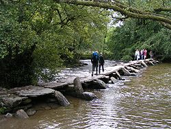
The clapper bridge at Postbridge
A fine example, the Postbridge Clapper Bridge, can be found at Postbridge, on Dartmoor. Its slabs are over 4 metres (13ft) long, 2 metres (6ft 7in) wide and weigh over 8 metric tons (7.9 long tons; 8.8 short tons) each, making the bridge passable to a small cart. It was first recorded in 1380 and was built to facilitate the transportation of Dartmoor tin by pack horses to the stannary town of Tavistock.
Clapper bridge at Wycoller, Pendle, East Lancashire
Some larger clapper bridges, such as at Dartmeet and Bellever, have collapsed – their slabs swept away by floods, or raided for building or wall construction - and have since been rebuilt. However, there are many other smaller examples in existence on Dartmoor and still in use, such as those at Teignhead Farm (close to Grey Wethers stone circles), Scorhill and across the Wallabrook stream.
While the term "clapper bridge" is typically associated with the United Kingdom, other "clapper-style" bridges exist throughout the world. One example is the Anping Bridge in China, being over two kilometres long and one in Louisburgh, County Mayo in Ireland.
Notes
↑ French and Provençal clapier developed the additional significance of a rabbit warren. (OED, s.v. "clapper".)
This page is based on this Wikipedia article Text is available under the CC BY-SA 4.0 license; additional terms may apply. Images, videos and audio are available under their respective licenses.