Clearwater River (Saskatchewan)

Last updated

Clearwater River
Clearwater River valley (from Highway 63).JPG
Clearwater River valley near Fort McMurray
Map symbol-pin.svg
Athabasca Watershed-WCanada.png
Clearwater River is at red pin
Canada Alberta relief location map - transverse mercator proj.svg
Red pog.svg
Location of the mouth of the river in Alberta
Location
CountryCanada
Provinces
Physical characteristics
Source Broach Lake
  locationSaskatchewan
  coordinates 57°43′14″N109°22′30″W / 57.72056°N 109.37500°W / 57.72056; -109.37500
Mouth Athabasca River at
  location
Fort McMurray, Alberta
  coordinates
56°44′53″N111°23′1.4″W / 56.74806°N 111.383722°W / 56.74806; -111.383722
Length295 km (183 mi)
Basin features
River system Athabasca River drainage basin
[1] [2]

The Clearwater River [3] is located in the Canadian provinces of Saskatchewan and Alberta. It rises in the northern forest region of north-western Saskatchewan and joins the Athabasca River in north-eastern Alberta. It was part of an important trade route during the fur trade era and has been designated as a Canadian Heritage River.

Contents

Course

The Clearwater River has a total length of 295 kilometres (183 mi). It flows south-eastward from its headwaters at Broach Lake and turns to the south-west from Careen Lake to the Alberta / Saskatchewan border. From there it flows westward for a distance of 108 kilometres (67 mi) to join the Athabasca River at Fort McMurray. The section of the river in Fort McMurray is referred to as the Chant.[ citation needed ]

From Broach Lake at an elevation of 460 metres (1,510 ft) above sea level, the Clearwater drops about 150 metres (490 ft) to the confluence at Fort McMurray. Its waters eventually reach the Arctic Ocean via the Athabasca and Mackenzie Rivers. [4] Tributaries of the Clearwater River include Descharme River and McLean River in Saskatchewan and the Christina River in Alberta.

Geology

A salt spring discharges into the Clearwater River in northeastern Alberta. Clearwater River Salt Spring.jpg
A salt spring discharges into the Clearwater River in northeastern Alberta.

In its upper reaches, the Clearwater River flows over the Precambrian rocks of the Canadian Shield. That section of the river is rough, characterized by rapids, small waterfalls, and a gorge. The river leaves the Shield near the Alberta border and enters the Interior Plains where it becomes meandering, with numerous sand bars and small islands. [5] There it is flanked by outcrops of the Devonian limestones, dolomite, and shales of the La Loche, Contact Rapids, Keg River, and Waterways Formations, as well as the Cretaceous oil sands of the McMurray Formation. [6] [7]

The Clearwater River is an underfit stream; that is, its present flow is insufficient to have carved its broad, steep-sided valley. Instead, its morphology may be the result of catastrophic paleoflooding that originated from Glacial Lake Agassiz during late Pleistocene time and flowed through the Clearwater and Athabasca river valleys on its way to the Arctic Ocean. [8] [9] The channel cut by that flood is known as the Clearwater Spillway. [8]

There are several salt springs and saline marshes that discharge into the Clearwater River in northeastern Alberta. The water, which comes from the underlying Devonian rock formations, is effervescent in places and smells of sulfur. [10]

History

A section of John Franklin's 1819-20 expedition map showing the Clearwater River fur trade route from Methye Portage to Fort McMurray Franklin map fur route 3751971809 c0c67ca7d3 o huge map (2).jpg
A section of John Franklin's 1819-20 expedition map showing the Clearwater River fur trade route from Methye Portage to Fort McMurray
The Clearwater River valley from Methye Portage by George Back in 1825 Back, George Portage La Loche 1825.jpg
The Clearwater River valley from Methye Portage by George Back in 1825

Rock-paintings along the upper portion of the river, shapes and symbols on rock surfaces, suggest that the area was already inhabited 5,000 years ago. Before the European colonisation, native groups of Beaver, Chipewyan, and Cree people lived in the Clearwater River area. [5]

During European exploration and the fur trade of the 18th century, the lower Clearwater River was part of an important canoe route between Hudson Bay and Montreal in the east, and the District of Athabasca in the west. The rough Precambrian upper portion of the Clearwater River was a barrier to the traders until 1778, when explorer Peter Pond crossed the Methye Portage to bypass it. Methye Portage extended between Lac La Loche and the Clearwater River, forming a 19-kilometre (12 mi) overland link on the route from Churchill, Manitoba to Athabasca, Alberta. For almost 40 years, this was the only overland connection for the fur trade in the region, and it continued in use for most of the 19th century. [5]

Fish species

The river's fish species include: walleye, yellow perch, northern pike, lake trout, Arctic grayling, lake whitefish, cisco, white sucker, longnose sucker and burbot.[ citation needed ]

Conservation

Provincial park

The province of Saskatchewan has established the Clearwater River Provincial Park, encompassing an area of 865 mi2; or 2240 km2, to protect the river's environment. [11]

Canadian Heritage Rivers System

The Saskatchewan section was granted Canadian Heritage River status because of its "unspoiled, clear-water river in a pristine" isolated "wilderness setting of spectacular beauty". [12]

Regional Aquatics Monitoring Program (RAMP)

The Regional Aquatics Monitoring Program (RAMP) uses the Clearwater River as a "baseline river system" to provide "information on the variability and characteristics of natural systems". [4] Although natural outcrops of McMurray Formation oil sands are present along the river, the "lack of significant oil sands developments" within its watershed allows it to be used as a baseline. [4]

See also

Related Research Articles

<span class="mw-page-title-main">Athabasca River</span> Canadian river in Alberta

The Athabasca River is a river in Alberta, Canada, which originates at the Columbia Icefield in Jasper National Park and flows more than 1,231 km (765 mi) before emptying into Lake Athabasca. Much of the land along its banks is protected in national and provincial parks, and the river is designated a Canadian Heritage River for its historical and cultural importance. The scenic Athabasca Falls is located about 30 km (19 mi) upstream from Jasper.

<span class="mw-page-title-main">Lake Athabasca</span> Lake in Western Canada

Lake Athabasca is in the north-west corner of Saskatchewan and the north-east corner of Alberta between 58° and 60° N in Canada. The lake is 26% in Alberta and 74% in Saskatchewan.

<span class="mw-page-title-main">Regional Municipality of Wood Buffalo</span> Municipality in Alberta, Canada

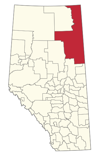
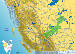
The Regional Municipality of Wood Buffalo is a specialized municipality in northeast Alberta, Canada. It is the second largest municipality in Alberta by area and is home to oil sand deposits known as the Athabasca oil sands.

<span class="mw-page-title-main">Churchill River (Hudson Bay)</span> River in Manitoba and Saskatchewan, Canada

The Churchill River is a major river in Alberta, Saskatchewan and Manitoba, Canada. From the head of the Churchill Lake it is 1,609 kilometres (1,000 mi) long. It was named after John Churchill, 1st Duke of Marlborough and governor of the Hudson's Bay Company from 1685 to 1691.

The Methye Portage or Portage La Loche in northwestern Saskatchewan was one of the most important portages in the old fur trade route across Canada. The 19 km (12 mi) portage connected the Mackenzie River basin to rivers that ran east to the Atlantic. It was reached by Peter Pond in 1778 and abandoned in 1883 when steamboats began running on the Athabasca River with links to the railroad. It ranks with Grand Portage as one of the two most important and difficult portages used during the fur trade era.

<span class="mw-page-title-main">La Loche</span> Northern village in Saskatchewan, Canada

La Loche is a village in northwest Saskatchewan. It is located at the end of Highway 155 on the eastern shore of Lac La Loche in Canada's boreal forest. La Loche had a population of 2,827 in 2016 and is within the Northern Saskatchewan Administration District.

<span class="mw-page-title-main">Northern Alberta</span> Geographic region of Alberta, Canada

Northern Alberta is a geographic region located in the Canadian province of Alberta.

<span class="mw-page-title-main">Fort McKay First Nation</span>

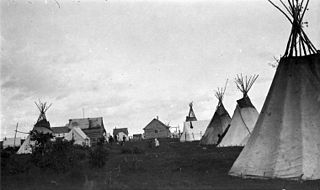
The Fort McKay First Nation (FMFN) is a First Nations government in northeast Alberta comprising five Indian reserves – Fort McKay 174, Fort McKay 174C, Fort McKay 174D, Namur Lake 174B and Namur River 174A. The FMFN, signed to Treaty 8, is affiliated with the Athabasca Tribal Council and its members are of Cree, Metis and Dene heritage. The FMFN's traditional lands include portions of the Athabasca oil sands.

The Clearwater Formation is a stratigraphic unit of Early Cretaceous (Albian) age in the Western Canada Sedimentary Basin in northeastern Alberta, Canada. It was first defined by R.G. McConnell in 1893 and takes its name from the Clearwater River near Fort McMurray.

<span class="mw-page-title-main">McMurray Formation</span> Geological formation in Alberta, Canada

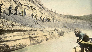
The McMurray Formation is a stratigraphic unit of Early Cretaceous age of the Western Canada Sedimentary Basin in northeastern Alberta. It takes the name from Fort McMurray and was first described from outcrops along the banks of the Athabasca River 5 kilometres (3.1 mi) north of Fort McMurray by F.H. McLearn in 1917. It is a well-studied example of fluvial to estuarine sedimentation, and it is economically important because it hosts most of the vast bitumen resources of the Athabasca Oil Sands region.

Christina Lake is an elongate lake in northern Alberta, Canada, located near Highway 881 east of Conklin, between Lac La Biche and Fort McMurray. Christina Lake and the Christina River are named to honour Christine Gordon, originally from Scotland, who was the first white woman to live permanently in the Fort McMurray area.

The Beaverhill Lake Group is a geologic unit of Middle Devonian to Late Devonian age in the Western Canada Sedimentary Basin that is present in the southwestern Northwest Territories, northeastern British Columbia and Alberta. It was named by the geological staff of Imperial Oil in 1950 for Beaverhill Lake, Alberta, based on the core from a well that they had drilled southeast of the lake, near Ryley, Alberta.

<span class="mw-page-title-main">Elk Point Group</span>

The Elk Point Group is a stratigraphic unit of Early to Middle Devonian age in the Western Canada and Williston sedimentary basins. It underlies a large area that extends from the southern boundary of the Northwest Territories in Canada to North Dakota in the United States. It has been subdivided into numerous formations, number of which host major petroleum and natural gas reservoirs.

<span class="mw-page-title-main">Cold Lake oil sands</span> Large deposit of petroleum in Alberta, Canada

The Cold Lake oil sands are a large deposit of oil sands located near Cold Lake, Alberta. Cold Lake is east of Alberta's capital, Edmonton, near Alberta's border with Saskatchewan, and a small portion of the Cold Lake field lies in Saskatchewan.

Waterways is a locality within the Regional Municipality of Wood Buffalo in northern Alberta, Canada. It is now a neighbourhood within the Fort McMurray urban service area along the west bank of the Clearwater River, south of the river's confluence with the Athabasca River.

<span class="mw-page-title-main">Clearwater River Provincial Park</span> Provincial park in Saskatchewan, Canada

Clearwater River Provincial Park is a Canadian wilderness park in the boreal forest of northern Saskatchewan. The park begins at the south end of Lloyd Lake on the Clearwater River and includes territory on both sides of the river until it reaches the Alberta border.

<span class="mw-page-title-main">Lac La Loche</span> Lake in Saskatchewan, Canada

Lac La Loche is a lake in north west Saskatchewan near the Alberta border. The lake is part of the Churchill River system that flows into the Hudson Bay. The La Loche River at the southern end flows into Peter Pond Lake which is connected to Churchill Lake.

<span class="mw-page-title-main">Christina River (Alberta)</span> River in Alberta, Canada

The Christina River is located in the Wood Buffalo region of north-eastern Alberta, Canada. The Christina is a tributary of the Clearwater River and was named to honour Christine Gordon, who was the first white women to live permanently in the Fort McMurray area.

The La Loche Formation is a geologic formation of early Middle Devonian (Eifelian) age in the Western Canada Sedimentary Basin. It is present in northeastern Alberta and northwestern Saskatchewan and was first described by A. W. Norris in 1963, who named it for a Roman Catholic Mission at Lac La Loche. Its type section is located at Contact Rapids on the Clearwater River in Saskatchewan, northwest of Lac La Loche. It is not fossiliferous.

<span class="mw-page-title-main">La Saline Natural Area</span> Nature preserve in Canada

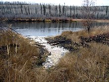
La Saline Natural Area in the boreal forest of northeastern Alberta, Canada, preserves Saline Lake, a saline oxbow lake adjacent to the Athabasca River north of Fort McMurray. The lake is an important stop for waterfowl and other birds that migrate along the Athabasca River. Large deposits of tufa have accumulated around the salt springs on the lake's southeastern shore.

References

  1. "Natural Resources Canada-Canadian Geographical Names (Clearwater River)" . Retrieved 29 August 2014.
  2. "Atlas of Canada Toporama" . Retrieved 29 August 2014.
  3. Government of Canada, Natural Resources Canada. "Place names - Clearwater River". www4.rncan.gc.ca.
  4. 1 2 3 "Clearwater River Hydrological Profile". Hydrology of the Athabasca Oil Sands Region. Regional Aquatics Monitoring Program RAMP. Retrieved 7 April 2018.
  5. 1 2 3 "Clearwater River fact sheet". Canadian Heritage Rivers System. Archived from the original on 20 June 2018. Retrieved 7 April 2018.
  6. Schneider, C.L., Grobe, M. and Hein, F.J. 2013. Outcrops of the La Loche, Contact Rapids, and Keg River formations (Elk Point Group, Devonian) on the Clearwater River, Alberta (NTS 74D/9) and Saskatchewan (NTS 74C/12). Energy Resources Conservation Board, ERCB/AGS Open File Report 2012-20, 36 p.
  7. Prior, G. J., Hathaway, B., Glombick, P.M., Pana, D.I., Banks, C.J., Hay, D.C., Schneider, C.L., Grobe, M., Elgr, R., and Weiss, J.A. (2013). "Bedrock Geology of Alberta. Alberta Geological Survey, Map 600". Archived from the original on 26 June 2016. Retrieved 20 June 2016.{{cite web}}: CS1 maint: multiple names: authors list (link)
  8. 1 2 Smith, D.G. and Fisher, T.G. 1993. Glacial Lake Agassiz: The northwestern outlet and paleoflood. Geology, vol. 21, p. 9-12.
  9. Fisher, Timothy G.; Smith, Derald G.; Andrews, John T. (2002). "Preboreal oscillation caused by a glacial Lake Agassiz flood" (PDF). Quaternary Science Reviews. 21 (2002): 873–78. Bibcode:2002QSRv...21..873F. doi:10.1016/S0277-3791(01)00148-2. Archived from the original (PDF) on 22 February 2014. Retrieved 6 April 2018.
  10. Gue, A.E. 2012. The geochemistry of saline springs in the Athabasca oil sands region and their impact on the Athabasca and Clearwater Rivers. Unpublished M.Sc. thesis, University of Calgary, Alberta, 159 p.
  11. Saskatchewan Parks Archived 2005-11-25 at the Wayback Machine - Clearwater River Park
  12. "Clearwater River designation". Canadian Heritage Rivers System. Retrieved 7 April 2018.