Clermont, Capitale-Nationale, Quebec

Last updated

Clermont
Ville de Clermont.JPG
Blason ville ca Clermont (Charlevoix-Est) (Quebec).svg
Clermont (Capitale-Nationale) Quebec location diagram.png
Location within Charlevoix-Est RCM
Canada Central Quebec location map.png
Red pog.svg
Clermont
Location in central Quebec
Coordinates: 47°41′N70°14′W / 47.683°N 70.233°W / 47.683; -70.233 [1]
CountryCanada
Province Quebec
Region Capitale-Nationale
RCM Charlevoix-Est
Settled1800
ConstitutedFebruary 16, 1935
Government
[2]
  MayorLuc Cauchon
   Federal riding Beauport—Côte-de-Beaupré—Île d'Orléans—Charlevoix
   Prov. riding Charlevoix–Côte-de-Beaupré
Area
  Total52.30 km2 (20.19 sq mi)
  Land51.53 km2 (19.90 sq mi)
Population
 (2021) [3]
  Total3,065
  Density59.5/km2 (154/sq mi)
  Pop 2016-2021
Decrease2.svg 0.6%
  Dwellings
1,490
Time zone UTC−5 (EST)
  Summer (DST) UTC−4 (EDT)
Postal code(s)
G4A
Area code(s) 418 and 581
HighwaysQc138.svg R-138
Website www.ville.clermont.qc.ca

Clermont is a ville in the Canadian province of Quebec, and the seat of government for the Charlevoix-Est Regional County Municipality. It is located on the southern banks of the Malbaie River.

Contents

History

Around 1800, the first settlers moved into the area, living primarily of agriculture. Followed by a saw and flour mill, tradeshops, and stores, a settlement grew that was then known as Chute Nairne. At the close of the century, the place attracted attention for its hydro-electric potential, and by 1900, a dam was built across the Malbaie River, supplying electricity to La Malbaie and surrounding area. [4]

In 1909, Rodolphe Forget founded the East Canada Power and Pulp Company, and wanting to profit from the phenomenal growth in the pulp and paper market, he built Chute Nairne's first paper mill in 1911. The industrial development changed the place from a rural and agricultural society to a rapidly growing urban community. [4]

Félix-Antoine Savard, famous Québécois author and at that time priest of the Parish of Saint-Étienne in La Malbaie, was also responsible for Chute Nairne. His parishioners there were upset about being left a bit to themselves and about being far away from the parish church. Savard, at the request of residents of Chute Nairne, petitioned the bishop of Chicoutimi, Charles Lamarche, to obtain permission for a new parish and church. The request was accepted on September 18, 1931, and the Parish of Saint-Philippe-de-la-Chute-Nairn was formed. [4]

On February 16, 1935, the place separated from La Malbaie and was incorporated as a municipality, officially adopting the name Clermont for the new municipality. Félix-Antoine Savard greatly admired and paid tribute to Blaise Pascal who came from Clermont-Ferrand in France. [1] [4]

In 1949, Clermont changed its status to village and in 1967 to town. [1]

Demographics

Historical Census Data - Clermont (Capitale-Nationale), Quebec [5]
YearPop.±%
1941 1,318    
1951 2,027+53.8%
1956 2,628+29.6%
1961 3,114+18.5%
1966 3,175+2.0%
1971 3,386+6.6%
1976 3,518+3.9%
1981 3,621+2.9%
1986 3,426−5.4%
1991 3,385−1.2%
1996 3,225−4.7%
2001 3,078−4.6%
2006 3,041−1.2%
2011 3,118+2.5%
2016 3,085−1.1%
2021 3,065−0.6%

In the 2021 Census of Population conducted by Statistics Canada, Clermont had a population of 3,065 living in 1,429 of its 1,490 total private dwellings, a change of

Mother tongue:

Economy

Poster evoking "The Paper Workers Union of Clermont" installed in front of a small lake at the municipal lake of Clermont, on the west bank of the Malbaie river, on the path of the bike path. Lac au parc municipal de Clermont-2018-07-20.jpg
Poster evoking "The Paper Workers Union of Clermont" installed in front of a small lake at the municipal lake of Clermont, on the west bank of the Malbaie river, on the path of the bike path.

Clermont's economy centres on the Abitibi-Bowater paper mill, formerly the Donohue mill that was founded in 1936 by the brothers Timothy and Charles Donohue and employed close to a thousand people in the 1970s. [4]

Clermont is also the end of the Charlevoix Railway and therefore is an intermodal freight transport hub primarily for wood.

Attractions

The location of the city of Clermont makes it conducive to outdoor activities of all kinds. First, the fishermen are pampered because of the presence of a salmon river; the Malbaie River. Moreover, this river is the central point of various activities including the Festival of Fishing . Other outdoor activities are also feasible such as hiking. An ice hockey arena is available for ice hockey and ice skating enthusiasts. The city of Clermont also hosts the Boomerang Charlevoix, a team of the Hockey League Beauce-Bellechasse-Frontenac.

Charlevoix impact structure

The Charlevoix impact structure in which the city of Clermont is located is a meteorite impact structure of 56 kilometres (35 mi) created 350 million years ago by the impact of a meteorite of 2 kilometres (1.2 mi) in diameter. In July and August, from Baie Saint-Paul, it is possible to participate daily in guided tours of the impact structure organized by a non-profit scientific organization. [7] These visits reveal the geology of the region, the origin of the impact structure, the human developments made possible by the impact structure and the region's diverse flora, which is also the result of the presence of the impact structure. During the rest of the year, the same visits are organized on request.

Monument Alexis Lapointe (known as "The Trotter")

Image of the Monument erected in honor of Alexis Lapointe (1860-1924) at Des Berges Municipal Park in Clermont, QC, was renowned for being one of the greatest runners of his day. Monument d'Alexis Lapointe (dit le Trotteur) au parc municipal de Clermont (Charlevoix)-2018-07-20.jpg
Image of the Monument erected in honor of Alexis Lapointe (1860-1924) at Des Berges Municipal Park in Clermont, QC, was renowned for being one of the greatest runners of his day.

The August 8, 2010, a monument of the artist Léonce Émond was inaugurated at the Des Berges City Park of Clermont, near the Malbaie River, to evoke the memory of Alexis Lapointe (known as "The Trotter") (1860-1924 ). The latter was reputed to be one of the greatest runners of his time.

Malbaie River

The bottom of the Malbaie River is rocky and generally shallow. This river is conducive for the recovery of several species of fish including salmon and ouaniche It is also conducive to the descent of its course in light craft. Riviere Malbaie a Clairmont, pres du parc municipal. Photo prise de la rive Ouest-2018-07-20.jpg
The bottom of the Malbaie River is rocky and generally shallow. This river is conducive for the recovery of several species of fish including salmon and ouaniche It is also conducive to the descent of its course in light craft.

The Malbaie River, which crosses the city of Clermont towards the South, is a great attraction for recreational tourism activities, such as salmon fishing or landlocked salmon. A bike path generally in wooded area runs along the west bank of the Malbaie River passing in particular in the municipal park Des Berges, bypassing some small bodies of water and the water treatment center, to the bridge spanning the river.

See also

Related Research Articles

<span class="mw-page-title-main">Charlevoix</span> Region of Quebec, Canada

Charlevoix is a cultural and natural region in Quebec, on the north shore of the Saint Lawrence River as well as in the Laurentian Mountains area of the Canadian Shield. This dramatic landscape includes rolling terrain, fjords, headlands, and bays; the region was designated a World Biosphere Reserve by UNESCO in 1989. Administratively, it comprises the Charlevoix and Charlevoix-Est regional county municipalities within the larger Capitale-Nationale administrative region.

<span class="mw-page-title-main">Baie-Saint-Paul</span> City in Quebec, Canada

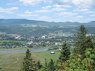
Baie-Saint-Paul is a city in the Province of Quebec, Canada, on the northern shore of the Saint Lawrence River. Baie-Saint-Paul is the seat of Charlevoix Regional County Municipality. The city is situated at the mouth of the Gouffre River. It is known for its art galleries, shops and restaurants.

<span class="mw-page-title-main">Capitale-Nationale</span> Administrative region in Quebec, Canada

Capitale-Nationale is one of the 17 administrative regions of Quebec. It is anchored by the provincial capital, Quebec City, and is largely coextensive with that city's metropolitan area. It has a land area of 18,797.45 km2. It reported a total resident population of 729,997 as of the Canada 2016 Census, with Quebec City having 73.7 percent of the total.

<span class="mw-page-title-main">La Malbaie</span> City in Quebec, Canada

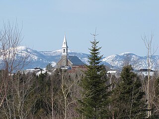
La Malbaie is a municipality in the Charlevoix-Est Regional County Municipality in the Province of Quebec, Canada, situated on the north shore of the St. Lawrence River at the mouth of the Malbaie River. It was formerly known as Murray Bay. La Malbaie is the seat of the judicial district of Charlevoix.

<span class="mw-page-title-main">Malbaie River</span> Tributary of the St. Lawrence River, MRC de Charlevoix-east (Quebec, Canada)

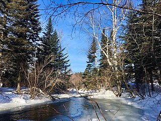
The Malbaie River in the Charlevoix region empties into the Saint Lawrence River at La Malbaie. Until 1985 the river was used to transport logs downstream. It flows through a steep valley known as Les Hautes Gorges. A sugar maple and American elm forest grows in the gorge and has remained largely undisturbed for hundreds of years.

<span class="mw-page-title-main">Félix-Antoine Savard</span>

Félix-Antoine Savard, was a Canadian priest, academic, poet, novelist and folklorist.

<span class="mw-page-title-main">Hautes-Gorges-de-la-Rivière-Malbaie National Park</span> Park in Quebec, Canada

The Hautes-Gorges-de-la-Rivière-Malbaie National Park is a provincial park in the Charlevoix region of Quebec, Canada. Centring on the Malbaie River Gorge, it is the centrepiece of the UNESCO Charlevoix biosphere reserve. Despite its name, it is not in Canada's national park system, nor administered by Parks Canada. It is administered by the Société des établissements de plein air du Québec (Sépaq). The park can be reached via a local road, 30 kilometers (19 mi) northwards from Route 138 in Saint-Aimé-des-Lacs.

<span class="mw-page-title-main">Saint-Hilarion, Quebec</span> Parish municipality in Quebec, Canada

Saint-Hilarion is a parish municipality in Charlevoix Regional County Municipality, in the administrative region of Capitale-Nationale of the province of Quebec, in Canada.

<span class="mw-page-title-main">Saint-Siméon, Capitale-Nationale, Quebec</span> Municipality in Quebec, Canada

Saint-Siméon is a municipality in the Charlevoix-Est Regional County Municipality of Quebec, Canada. Founded in 1869, it was named after Saint Simeon of Jerusalem.

<span class="mw-page-title-main">Charlevoix Railway</span> Railway in Quebec

The Charlevoix Railway is a short-line railway that operates in the Charlevoix region of Quebec Canada. From 1994 to 2009 it was a subsidiary of the Quebec Railway Corporation, a short line operator. Since April 2009 it has been owned by Train touristique de Charlevoix Inc., a Groupe Le Massif Inc. subsidiary. With a length of 144–148 kilometres (89–92 mi) it connects the city of Clermont in the Charlevoix region to a freight yard of the Canadian National Railway (CN) located in the La Cité-Limoilou borough of the city of Quebec. The railway runs along both the St. Lawrence River and the Malbaie River and consists of a single non-electrified track.

Charlevoix–Côte-de-Beaupré is a provincial electoral district in the Capitale-Nationale region of Quebec, Canada, that elects members to the National Assembly of Quebec. It consists of the entire territory of the following regional county municipalities: L'Île-d'Orléans, La Côte-de-Beaupré, Charlevoix, Charlevoix-Est. It notably includes the municipalities of La Malbaie, Boischatel, Baie-Saint-Paul, L'Ange-Gardien, Château-Richer, Beaupré, Saint-Ferréol-les-Neiges and Clermont.

<span class="mw-page-title-main">Cap-à-l'Aigle</span> Geographic area in Quebec, Canada

Cap-à-l'Aigle is an area located in the east end of La Malbaie, in Charlevoix-Est Regional County Municipality (RCM), in the administrative region of Capitale-Nationale, Quebec, Canada. Formerly constituted as a municipality, this territory was merged with the city of La Malbaie on December 1, 1999. This area has a mountain village on the banks of the St. Lawrence River.

Zec du Lac-au-Sable is a "zone d'exploitation contrôlée" (zec) located in the unorganized territory of Mont-Élie, in Charlevoix-Est Regional County Municipality, in administrative region of Capitale-Nationale, Quebec, Canada.

The Comporté River is a tributary of the Malbaie River flowing generally southward into the territory of the town of La Malbaie in the Eastern part of the Charlevoix Regional County Municipality, in Quebec, in Canada. This river has a gap in elevation of 489 m (1,604 ft). After several series of rapids, waterfalls and falls in forest area, it flows into the Malbaie River between the village of Clermont and the town of La Malbaie.

The Jacob River is a tributary of the north shore of the Malbaie River flowing generally southward successively into zec du Lac-au-Sable into the unorganized territory of Mont-Élie, in the city of La Malbaie and in the city of Clermont at the end of the course, in Charlevoix-Est Regional County Municipality, in Quebec, Canada.

<span class="mw-page-title-main">Snigole River</span> River in Quebec, Canada

The Snigole River is a tributary of the north shore of the Malbaie River flowing generally to the south, especially in the zec du Lac-au-Sable in the unorganized territory of Mont-Élie, then in the territory of Clermont at the end of the route, in the Charlevoix-Est Regional County Municipality, in Quebec, Canada.

<span class="mw-page-title-main">Port au Saumon River</span> Tributary of the St. Lawrence River, MRC Charlevoix-east (Quebec, Canada)

The Port-au-Saumon River is a tributary of the northwest shore of the St. Lawrence River, flowing into the town of La Malbaie, into the Charlevoix-Est Regional County Municipality, in the Capitale-Nationale administrative region, Quebec, Canada. The course of this river flows into the St. Lawrence River in the hamlet of Port-au-Saumon, northeast of the town of La Malbaie.

<span class="mw-page-title-main">Rivière du Gouffre</span> River in Charlevoix (Québec, Canada)

The rivière du Gouffre is a tributary of the left bank of the Saint-Laurent river, flowing into the Capitale-Nationale administrative region, Quebec (Canada). This watercourse flows through Regional County Municipality from:

The Rivière des Boudreault is a tributary of the northwest shore of the St. Lawrence River, in the municipality of Les Éboulements, in the Charlevoix Regional County Municipality, in the administrative region of Capitale-Nationale, in the province of Quebec, in Canada.

<span class="mw-page-title-main">Charlevoix Biosphere Reserve</span> UNESCO Biosphere Reserve in Quebec, Canada

The Charlevoix Biosphere Reserve is part of the Man and the Biosphere Program of the UNESCO. It is managed by the Charlevoix Biosphere Reserve Corporation.

References

  1. 1 2 3 "Clermont (Ville)" (in French). Commission de toponymie du Québec. Retrieved 2010-05-21.
  2. 1 2 Ministère des Affaires municipales, des Régions et de l'Occupation du territoire - Répertoire des municipalités: Clermont Archived 2015-12-11 at the Wayback Machine
  3. 1 2 Statistics Canada 2021 Census - Clermont census profile
  4. 1 2 3 4 5 "Informations municipales >> Historique de la ville" (in French). Ville de Clermont. Retrieved 2010-05-21.
  5. Statistics Canada: 1996, 2001, 2006, 2011 census
  6. "Population and dwelling counts: Canada, provinces and territories, and census subdivisions (municipalities), Quebec". Statistics Canada. February 9, 2022. Retrieved August 29, 2022.
  7. "Observatoire de l'Astroblème de Charlevoix". Tourisme Charlevoix. Retrieved 2021-12-31.