Cole Camp, Missouri

Last updated

Cole Camp, Missouri
Benton County Missouri Incorporated and Unincorporated areas Cole Camp Highlighted.svg
Location of Cole Camp, Missouri
Coordinates: 38°27′34″N93°12′09″W / 38.45944°N 93.20250°W / 38.45944; -93.20250
Country United States
State Missouri
County Benton
Area
[1]
  Total1.30 sq mi (3.37 km2)
  Land1.30 sq mi (3.37 km2)
  Water0.00 sq mi (0.00 km2)
Elevation
[2]
1,053 ft (321 m)
Population
 (2020)
  Total1,104
  Density847.93/sq mi (327.47/km2)
Time zone UTC-6 (Central (CST))
  Summer (DST) UTC-5 (CDT)
ZIP code
65325
Area code 660
FIPS code 29-15436 [3]
GNIS feature ID2393592 [2]

Cole Camp is a small city in Benton County, Missouri, United States. The population was 1,121 at the 2010 census.

Contents

The town is known for the annual street fair in September. It also hosts a Maifest in May, an Oktoberfest in October, and a Christbaumfest in late November; all highlight the town's German heritage.

History

Cole Camp was laid out in 1857. [4] The city most likely was named after pioneer Captain Stephen Cole. [5] The first postmaster of Cole Camp was Ezekiel Williams, Sr., appointed February 26, 1839. [6]

Cole Camp was the site of a skirmish early in the American Civil War, when the local pro-Union Home Guard company was attacked by a Missouri State Guard force on June 19, 1861. At the Battle of Cole Camp, the Home Guard were defeated with a loss of 35 men killed or wounded.

The Central Cole Camp Historic District and Augustus Sander House are listed on the National Register of Historic Places. [7]

Geography

Cole Camp is located in northeast Benton County along Missouri Route 52 approximately four miles west of US Route 65. The headwaters of Cole Camp Creek are adjacent to the west side of the community. [8]

According to the United States Census Bureau, the city has a total area of 1.30 square miles (3.37 km2), all land. [9]

Demographics

Historical population
CensusPop.Note
1900 648
1910 91040.4%
1920 889−2.3%
1930 9324.8%
1940 753−19.2%
1950 8138.0%
1960 8534.9%
1970 1,03821.7%
1980 1,022−1.5%
1990 1,0543.1%
2000 1,028−2.5%
2010 1,1219.0%
2020 1,104−1.5%
U.S. Decennial Census [10]

2010 census

As of the census [11] of 2010, there were 1,121 people, 492 households, and 286 families residing in the city. The population density was 862.3 inhabitants per square mile (332.9/km2). There were 560 housing units at an average density of 430.8 per square mile (166.3/km2). The racial makeup of the city was 98.2% White, 0.1% Native American, 0.3% Asian, 0.3% from other races, and 1.2% from two or more races. Hispanic or Latino of any race were 0.9% of the population.

There were 492 households, of which 27.0% had children under the age of 18 living with them, 45.1% were married couples living together, 10.0% had a female householder with no husband present, 3.0% had a male householder with no wife present, and 41.9% were non-families. 38.0% of all households were made up of individuals, and 26.2% had someone living alone who was 65 years of age or older. The average household size was 2.16 and the average family size was 2.85.

The median age in the city was 47.3 years. 21.6% of residents were under the age of 18; 7.1% were between the ages of 18 and 24; 18.2% were from 25 to 44; 23.5% were from 45 to 64; and 29.5% were 65 years of age or older. The gender makeup of the city was 44.7% male and 55.3% female.

2000 census

As of the census [3] of 2000, there were 1,028 people, 451 households, and 261 families residing in the city. The population density was 1,050.6 inhabitants per square mile (405.6/km2). There were 493 housing units at an average density of 503.8 per square mile (194.5/km2). The racial makeup of the city was 98.93% White, 0.10% African American, 0.10% Native American, 0.19% Asian, and 0.68% from two or more races. Hispanic or Latino of any race were 0.49% of the population.

There were 451 households, out of which 25.9% had children under the age of 18 living with them, 49.2% were married couples living together, 5.8% had a female householder with no husband present, and 42.1% were non-families. 40.8% of all households were made up of individuals, and 27.5% had someone living alone who was 65 years of age or older. The average household size was 2.16 and the average family size was 2.96.

In the city the population was spread out, with 21.9% under the age of 18, 7.9% from 18 to 24, 24.3% from 25 to 44, 17.5% from 45 to 64, and 28.4% who were 65 years of age or older. The median age was 42 years. For every 100 females, there were 80.0 males. For every 100 females age 18 and over, there were 77.7 males.

The median income for a household in the city was $26,190, and the median income for a family was $37,250. Males had a median income of $26,827 versus $22,500 for females. The per capita income for the city was $17,280. About 2.1% of families and 6.2% of the population were below the poverty line, including 0.5% of those under age 18 and 14.1% of those age 65 or over.

Education

Cole Camp R-1 School District operates one public elementary school, one middle school, and Cole Camp High School. [12] Cole Camp Methodist Pre-School and Trinity Lutheran Pre-School are private institutions. Lutheran School Association is a K-8 school in the community and the majority of those students attend Cole Camp High School. [13] As of 2022 Cole Camp High School is ranked by U.S. News and World Report as the #195 best high school in Missouri, with an enrollment of 222 students. [14]

Cole Camp has a public library, a branch of the Boonslick Regional Library. [15]

Notable people

See also

Related Research Articles

<span class="mw-page-title-main">Pettis County, Missouri</span> County in Missouri, United States

Pettis County is a county located in west central U.S. state of Missouri. As of the 2020 census, the population was 42,980. Its county seat is Sedalia. The county was organized on January 24, 1833, and named after former U.S. Representative Spencer Darwin Pettis.

<span class="mw-page-title-main">Benton County, Missouri</span> County in Missouri, United States

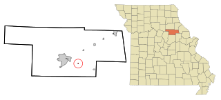
Benton County is a county located in the west central part of the U.S. state of Missouri. The population was 19,394 as of the 2020 Census. Its county seat is Warsaw. The county was organized January 3, 1835, and named for U.S. Senator Thomas Hart Benton of Missouri.

<span class="mw-page-title-main">Sulphur Springs, Benton County, Arkansas</span> City in Arkansas, United States

Sulphur Springs is a city in Benton County, Arkansas, United States. The population was 481 at the 2020 census. It is part of the Northwest Arkansas region.

<span class="mw-page-title-main">Norway, Iowa</span> City in Iowa, United States

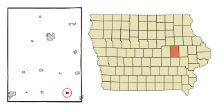
Norway is a city in Benton County, Iowa, United States. The population was 466 at the time of the 2020 census. The city is approximately 17 miles (27 km) southwest of downtown Cedar Rapids. It is part of the Cedar Rapids Metropolitan Statistical Area. Norway is the setting of the movie The Final Season.

<span class="mw-page-title-main">Benton City, Missouri</span> Village in Missouri, United States

Benton City is a village in Audrain County, Missouri, United States. The population was 104 at the 2010 census.

<span class="mw-page-title-main">Golden City, Missouri</span> City in Missouri, United States

Golden City is a city in Golden City Township, Barton County, Missouri, United States. The population was 656 at the 2020 census.

<span class="mw-page-title-main">Warsaw, Missouri</span> City in Missouri, United States

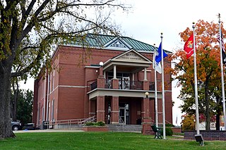
Warsaw is a city located in Benton County, Missouri, United States. The population was 2,127 at the 2010 census. Warsaw is the county seat of Benton County.

<span class="mw-page-title-main">Climax Springs, Missouri</span> Census-designated place in Missouri, United States

Climax Springs is a census-designated place and former village in Camden County, Missouri, United States. The population was 124 at the 2010 census.

<span class="mw-page-title-main">Mercer, Missouri</span> City in Missouri, United States

Mercer is a city in Mercer County, Missouri, United States. The population was 263 at the 2020 census.

<span class="mw-page-title-main">Wellsville, Missouri</span> City in Missouri, United States

Wellsville is a city in Montgomery County, Missouri, United States. The population was 998 at the 2020 census.

Stover is a city in Morgan County, Missouri, United States. The population was 1,094 at the 2010 census.

<span class="mw-page-title-main">Alton, Missouri</span> City in Missouri, United States

Alton is a city and the county seat of Oregon County, Missouri, United States. The population was 707 at the 2020 census.

<span class="mw-page-title-main">Benton, Missouri</span> City in Missouri, United States

Benton is a city in Scott County, Missouri, United States. The population was 863 at the 2010 census. It is the county seat of Scott County.

<span class="mw-page-title-main">Oran, Missouri</span> City in Missouri, United States

Oran is a city in Scott County, Missouri, United States. The population was 1,294 at the 2010 census.

<span class="mw-page-title-main">Eminence, Missouri</span> City in Missouri, United States

Eminence is a city in Shannon County, Missouri, United States. The population was 515 at the 2020 census. It is the county seat of Shannon County.

<span class="mw-page-title-main">Oakland, Missouri</span> City in Missouri, United States

Oakland is a city in St. Louis County, Missouri, United States. The population was 1,381 at the 2010 census.

<span class="mw-page-title-main">Twin Oaks, Missouri</span> Village in Missouri, United States

Twin Oaks is a 4th class city in St. Louis County, Missouri, United States. The former Village of Twin Oaks changed its status to that of a city by public election in November 2016. The population was 392 at the 2010 census.

<span class="mw-page-title-main">Russellville, Missouri</span> City in Missouri, United States

Russellville is a city in Cole County, Missouri, United States. The population was 778 at the 2020 census. It is part of the Jefferson City, Missouri Metropolitan Statistical Area.

<span class="mw-page-title-main">Montgomery City, Missouri</span> City in Missouri, United States

Montgomery City is a city in and the county seat of Montgomery County, Missouri, United States. The population was 2,811 at the 2020 census.

<span class="mw-page-title-main">Ionia, Missouri</span> Village in Missouri, United States

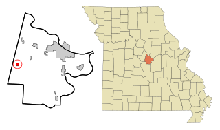
Ionia is a village in northern Benton and southern Pettis counties in the U.S. state of Missouri. The population was 88 at the 2010 census.

References

  1. "ArcGIS REST Services Directory". United States Census Bureau. Retrieved August 28, 2022.
  2. 1 2 U.S. Geological Survey Geographic Names Information System: Cole Camp, Missouri
  3. 1 2 "U.S. Census website". United States Census Bureau . Retrieved January 31, 2008.
  4. Eaton, David Wolfe (1916). How Missouri Counties, Towns and Streams Were Named. The State Historical Society of Missouri. pp.  209.
  5. "Benton County Place Names, 1928–1945 (archived)". The State Historical Society of Missouri. Archived from the original on June 24, 2016. Retrieved September 2, 2016.{{cite web}}: CS1 maint: bot: original URL status unknown (link)
  6. The National Archives, National Archives and Records Service, General Services Administration, Washington, 1973, National Archives Microfilm Publications, Microfilm Publication M841. Record of Appointment of Postmaster, 1832-September 30, 1971, Roll 70, Missouri, Adair - Clay Counties. Volume 12B, ca. 1832-44. p. 169, available at ancestry.com
  7. "National Register Information System". National Register of Historic Places . National Park Service. July 9, 2010.
  8. Missouri Atlas & Gazetteer, DeLorme, 1st ed., 1998, p.36 ISBN   0899332242
  9. "US Gazetteer files 2010". United States Census Bureau. Archived from the original on July 2, 2012. Retrieved July 8, 2012.
  10. "Census of Population and Housing". Census.gov. Retrieved June 4, 2015.
  11. "U.S. Census website". United States Census Bureau . Retrieved July 8, 2012.
  12. "Cole Camp R-I School District". GreatSchools. Retrieved March 18, 2018.
  13. "Area schools". Cole Camp Chamber of Commerce. Retrieved March 18, 2018.
  14. "Cole Camp High School in Cole Camp, MO". U.S. News and World Report. 2022. Retrieved November 20, 2022.
  15. "How do I get a library card?". Boonslick Regional Library. Retrieved March 18, 2018.