
A tram is a train that runs on tramway track on public urban streets; some include segments of segregated right-of-way. The lines or networks operated by tramcars as public transport are called tramways or simply tram/streetcar. Many recently built tramways use the contemporary term light rail. The vehicles are called streetcars or trolleys in North America and trams or tramcars elsewhere. The first two terms are often used interchangeably in the United States, with trolley being preferred in the eastern US and streetcar in Canada and the western US. In parts of the United States, internally powered buses made to resemble a streetcar are often referred to as "trolleys". To avoid further confusion with trolley buses, the American Public Transportation Association (APTA) refers to them as "trolley-replica buses". In the United States, the term tram has sometimes been used for rubber-tired trackless trains, which are unrelated to other kinds of trams.
Van Diemen's Land was the original name of the island of Tasmania during the European exploration of Australia in the 19th century. A British settlement was established in Van Diemen's Land in 1803 before it became a separate colony in 1825. Its penal colonies became notorious destinations for the transportation of convicts due to the harsh environment, isolation and reputation for being inescapable. Macquarie Harbour and Port Arthur are among the most well-known penal settlements on the island.

Port Arthur is a town and former convict settlement on the Tasman Peninsula, in Tasmania, Australia. It is located approximately 97 kilometres (60 mi) southeast of the state capital, Hobart.

Launceston is a major city in the north of Tasmania, Australia, at the junction of the North Esk and South Esk rivers where they become the Tamar River (kanamaluka). Launceston has a population of 110,472 in the significant urban area (2020). Launceston is the second most populous city in Tasmania after the state capital, Hobart, As of 2020, Launceston is the 17th largest city in Australia. Launceston is third-largest inland city and the ninth-largest non-capital city in Australia. Launceston is the most liveable regional city, and was one of the most popular regional cities to move to in Australia from 2020-21.
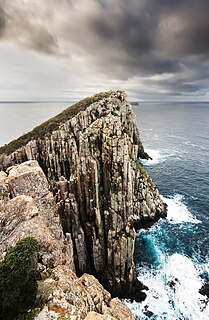
The Tasman Peninsula / Turrakana is a peninsula located in south-east Tasmania, Australia, approximately 75 km (47 mi) by the Arthur Highway, south-east of Hobart.
The history of Tasmania begins at the end of the most recent ice age when it is believed that the island was joined to the Australian mainland. Little is known of the human history of the island until the British colonisation in the 19th century.
Tasman Council is a local government body in Tasmania, situated in the south-east of the state. Tasman is classified as a rural local government area and has a population of 2,404, the region covers both the Tasman and Forestier peninsulas, with Nubeena the principal town.
Australians generally assumed in the 1850s that railways would be built by the private sector. Private companies built railways in the then colonies of Victoria, opened in 1854, and New South Wales, where the company was taken over by the government before completion in 1855, due to bankruptcy. South Australia's railways were government owned from the beginning, including a horse-drawn line opened in 1854 and a steam-powered line opened in 1856. In Victoria, the private railways were soon found not to be financially viable, and existing rail networks and their expansion were taken over by the colony. Government ownership also enabled railways to be built to promote development, even if not apparently viable in strictly financial terms. The railway systems spread from the colonial capitals, except in cases where geography dictated a choice of an alternate port.

The South Coast railway line is a commuter and goods railway line in New South Wales, Australia. Beginning at the Illawarra Junction, the line primarily services the Illawarra and South Coast regions of New South Wales, and connects Sydney and Bomaderry through Wollongong and Kiama.

The first railway in colonial South Australia was a horse-drawn tramway from the port of Goolwa on the Murray River to an ocean harbour at Port Elliot in 1854. Today the state has 1,600 mm broad gauge suburban railways in Adelaide, a number of country freight lines, as well as key 1,435 mm standard gauge links to other states.

The Forestier Peninsula is a peninsula located in south-east Tasmania, Australia, approximately 60 kilometres (37 mi) by the Arthur Highway, south-east of Hobart. The peninsula is connected to mainland Tasmania at East Bay Neck, near the town of Dunalley at its northern end. At Eaglehawk Neck, the southern end of the Forestier Peninsula is connected to the Tasman Peninsula.
The Mount Dundas – Zeehan Railway was a railway line running 7 miles (11 km) from Dundas to Zeehan on the West Coast of Tasmania. It operated from 1892 until 1932, and the rails were removed in 1940.

Taranna is a rural locality in the local government area (LGA) of Tasman in the South-east LGA region of Tasmania. The locality is about 16 kilometres (9.9 mi) north-east of the town of Nubeena. The 2016 census provides a population of 156 for the state suburb of Taranna. It is a hamlet on the Tasman Peninsula. Local points of interest include its Presbyterian church, immediately adjacent to the Federation Chocolate Factory, and a Tasmanian Devil park, "Unzoo".

The Sydney–Perth rail corridor is a 1435 mmstandard gauge railway route that runs for 4352 kilometres (2704 mi) across Australia from Sydney, New South Wales, to Perth, Western Australia. Most of the route is under the control of the Australian Rail Track Corporation.
The city of Hobart, Tasmania is served by a wide variety of transport. While the city's main form of transport is private transport on the road network, transport is also available by bus, ferry and aircraft. A suburban train service operated between Hobart and Brighton from the 1870s until 31 December 1974. There has been, however, talk in recent years of reinstating a train service in the northern suburbs.

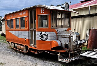
Zeehan railway station in Tasmania, was a major junction and railway yard for numerous different railway and tramway systems in western Tasmania in the town of Zeehan.
The Tasman Football Association was an Australian rules football competition in Tasmania, Australia. The association had origins back to 1902 when games were played at random. In 1919 a proper association was set up. The association went into recess during World War II but returned.

Koonya is a rural locality in the local government area (LGA) of Tasman in the South-east LGA region of Tasmania. The locality is about 18 kilometres (11 mi) north-east of the town of Nubeena. The 2016 census has a population of 134 for the state suburb of Koonya. It hosts the annual Koonya Garlic Festival, a "one-day celebration".
The Ida Bay Railway is a 7-kilometre (4.3 mi), 2 ft narrow gauge heritage railway. Located 105 kilometres (65 mi) south of Hobart, Tasmania, it is the most southerly railway in Australia.
