Coos County is a county in the U.S. state of Oregon. As of the 2010 census, the population was 63,043. The county seat is Coquille. The county was formed from the western parts of Umpqua and Jackson counties. It is named after a tribe of Native Americans who live in the region.

North Bend is a city in Coos County, Oregon, United States with a population of 9,695 as of the 2010 census. North Bend is surrounded on three sides by Coos Bay, an S-shaped water inlet and estuary where the Coos River enters Coos Bay and borders the city of Coos Bay to the south. North Bend became an incorporated city in 1903.

The Umpqua are any of several distinct groups of Native Americans that live in present-day south central Oregon in the United States.

The Coos River flows for about 5 miles (8.0 km) into Coos Bay along the Pacific coast of southwest Oregon in the United States. Formed by the confluence of its major tributaries, the South Fork Coos River and the Millicoma River, it drains an important timber-producing region of the Southern Oregon Coast Range. The course of the main stem and the major tributaries is generally westward from the coastal forests to the eastern end of Coos Bay near the city of Coos Bay.

Southwest Oregon Regional Airport, formerly North Bend Municipal Airport, is a public airport in North Bend, Coos County, Oregon. It is operated by the Coos County Airport District. OTH covers 619 acres of land.

The World is a daily newspaper in Coos Bay, Oregon, United States. From its office on Commercial Avenue in downtown Coos Bay, The World serves Oregon's South Coast, including the cities of Coos Bay, North Bend, Reedsport, Bandon, Lakeside, Coquille and Myrtle Point. The newspaper's circulation is 5,500 Monday–Thursday and 6,500 on Saturdays. It is the largest newspaper on the Oregon coast by circulation.

Charleston is an unincorporated community in Coos County, Oregon, United States. Charleston is the least populated community in Oregon's Bay Area and is Home to a large commercial fishing fleet, it is adjacent to the ocean entrance to Coos Bay. Charleston is the site of the Oregon Institute of Marine Biology and the United States Coast Guard Charleston Lifeboat Station.
The Coquille Indian Tribe is the federally recognized Native American tribe of the Coquille people
who have traditionally lived on the southern Oregon Coast.

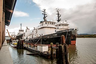
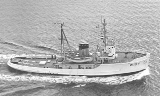
USS Coos Bay (AVP-25) was a United States Navy Barnegat-class small seaplane tender in commission from 1943 to 1946 that saw service during the latter half of World War II. After the war, she was in commission in the United States Coast Guard from 1949 to 1966 as the cutter USCGC Coos Bay (WAVP-376), later WHEC-376.

Oregon Islands National Wildlife Refuge is a U.S. National Wildlife Refuge off the southwestern Oregon Coast. It is one of six National Wildlife Refuges comprising the Oregon Coast National Wildlife Refuge Complex. The Oregon Islands provides wilderness protection to 1,853 small islands, rocks, and reefs plus two headlands, totaling 371 acres (150 ha) spanning 1,083 acres (438 ha) of Oregon's coastline from the Oregon–California border to Tillamook Head. There are sites in six of the seven coastal counties of Oregon. From north to south they are Clatsop, Tillamook, Lincoln, Lane, Coos, and Curry counties.

The history of steamboats on the Oregon Coast begins in the late 19th century. Before the development of modern road and rail networks, transportation on the coast of Oregon was largely water-borne. This article focuses on inland steamboats and similar craft operating in, from south to north on the coast: Rogue River, Coquille River, Coos Bay, Umpqua River, Siuslaw Bay, Yaquina Bay, Siletz River, and Tillamook Bay. The boats were all very small, nothing like the big sternwheelers and propeller boats that ran on the Columbia River or Puget Sound. There were many of them, however, and they came to be known as the "mosquito fleet."
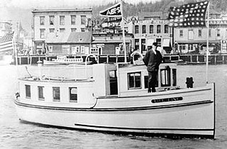
Life-Line was a Baptist missionary boat used to conduct ministry work in the Coos Bay region of southwestern Oregon, United States, from 1914 to 1923.

Green Acres is an unincorporated community in Coos County, Oregon, United States, east of Oregon Route 42 between Coos Bay and Coquille. It is near the southernmost point of the Isthmus Slough of Coos Bay.
The auxiliary ocean tug USS ATA-194 was laid down on 7 November 1944 at Orange, Texas, by the Levingston Ship Building Co.; launched 4 December 1944; and commissioned at Orange on 14 February 1945, Lieutenant (j.g.) William J. Bryan in command.
Beaver Hill is an unincorporated community in Coos County, Oregon, United States. It is about 12 miles (19 km) south of the city of Coos Bay, east of U.S. Route 101 and west of Oregon Route 42.

Southport is an unincorporated locale in Coos County, Oregon, United States. It was located along Southport Creek, near where the creek flows into Isthmus Slough, 6.5 miles (10 km) south of the city of Coos Bay, at an elevation of 30 feet. The former community is now a ghost town.
Glasgow is an unincorporated community in Coos County, Oregon, United States. For statistical purposes, the United States Census Bureau has defined Glasgow as a census-designated place (CDP). The census definition of the area may not precisely correspond to local understanding of the area with the same name. As of the 2010 census the Glasgow CDP had a population of 763. The place name for Glasgow in the Coos language is Kdet.