
The Republic of Colombia is situated largely in the north-west of South America, with some territories falling within the boundaries of Central America. It is bordered to the north-west by Panama; to the east by Brazil and Venezuela; to the south by Ecuador and Peru; and it shares maritime limits with Costa Rica, Nicaragua, Honduras, Jamaica, the Dominican Republic, and Haiti.

The geography of Bolivia includes the Eastern Andes Mountain Range which bisects Bolivia roughly from north to south. To the east of that mountain chain are lowland plains of the Amazon Basin, and to the west is the Altiplano which is a highland plateau where Lake Titicaca is located. Bolivia's geography has features similar to those of Peru which abuts Bolivia's northwest border; like Bolivia, Peru is bisected from north to south by the Eastern Andes Mountains, and these two countries share Lake Titicaca which is the highest navigable lake on Earth. Unlike Peru, however, Bolivia is one of the two landlocked countries in South America, the other being Paraguay, which is located along Bolivia's southeast border.

Huayhuash is a mountain range within the Andes of Peru, in the boundaries of the regions of Ancash, Lima and Huánuco. Since 2002 it is protected within the Cordillera Huayhuash Reserved Zone.
The Cordillera Blanca is a mountain range in Peru that is part of the larger Andes range and extends for 200 kilometres (124 mi) between 8°08' and 9°58'S and 77°00' and 77°52'W, in a northwesterly direction. It includes several peaks over 6,000 metres (19,690 ft) high and 722 individual glaciers. The highest mountain in Peru, Huascarán, at 6,768 metres (22,205 ft) high, is located there.
A cordillera is an extensive chain and/or network system of mountain ranges, such as those in the west coast of the Americas. The term is borrowed from Spanish, where the word comes from cordilla, a diminutive of cuerda ('rope').

The Cordillera de Mérida is a series of mountain ranges, or massif, in northwestern Venezuela. The Cordillera de Mérida is a northeastern extension of the Andes Mountains and the most important branch of the Venezuelan Andes. The ranges run southwest–northeast between the Venezuelan-Colombian border and the Venezuelan Coastal Ranges. The Táchira depression separates the Cordillera de Mérida from the Cordillera Oriental, which forms the Colombia-Venezuela border.
The Cordillera de Lípez is a mountain range in southern Potosí, Bolivia, and northern Argentina, part of the Andes. The range covers an area of 23,404 km2 (9,036 sq mi) and runs in a northeast–southwest direction, between the parallels 22 degrees and 23 degrees, helping to form the boundary between Bolivia and Argentina. Thus the Cordillera de Lípez is a transverse range in the Andes, between the Cordillera Oriental and the Cordillera Occidental, creating the southern boundary of the Bolivian Altiplano.

The Cordillera Oriental is the widest of the three branches of the Colombian Andes. The range extends from south to north dividing from the Colombian Massif in Huila Department to Norte de Santander Department where it splits into the Serranía del Perijá and the Cordillera de Mérida in Venezuelan Andes. The highest peak is Ritacuba Blanco at 5,410 m (17,750 ft) in the Sierra Nevada del Cocuy.

The Cordillera Oriental or Eastern Cordillera is a set of parallel mountain ranges of the Bolivian Andes, emplaced on the eastern and north eastern margin of the Andes. Large parts of Cordillera Oriental are forested and humid areas rich in agricultural and livestock products. Geologically, the Cordillera Oriental is formed by the Central Andean fold and thrust belt.
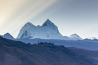
Salcantay, Salkantay or Sallqantay is the highest peak in the Vilcabamba mountain range, part of the Peruvian Andes. It is located in the Cusco Region, about 60 km (40 mi) west-northwest of the city of Cusco. It is the 38th-highest peak in the Andes and the twelfth-highest in Peru. However, as a range highpoint in deeply incised terrain, it is the second most topographically prominent peak in the country, after Huascarán.

Tuco,Tuku,Tucu or Huanaco Punta is a mountain in the Andes in South America. Its summit is 5,479 m (17,976 ft)) high and it is one of the southernmost peaks in the snow-capped Cordillera Blanca in northwestern central Peru. Tuco is located in the Ancash Region, Bolognesi Province, Aquia District and in the Recuay Province, Catac District. It is situated northeast of Caullaraju, between Challhua in the west and Pastoruri in the east.
The Cordillera Carabaya lies in the Andes of Peru. It extends between 14°00' and 14°22'S and 69°38' and 70°19'W for about 75 km. It is located in the Puno Region, Carabaya Province, between the Vilcanota mountain range in the north-west and the Apolobamba mountain range in the south-east, north and north-east of Macusani.
Allincapac,Allin Ccapac or Allin Japac is a mountain in the Andes of Peru. It is the highest peak of the Carabaya mountain range, rising up to 5,805 metres (19,045 ft). Allincapac is located in the Puno Region, Carabaya Province, Macusani District, south of Huaynaccapac, northeast of Chichicapac and north of Lake Chaupicocha.

The Huallanca mountain range (possibly from Quechua, wallanka mountain range; a cactus plant ; also called Chaupi Janca or Shicra Shicra lies in the Andes of Peru. It is located in the Ancash Region, Bolognesi Province. The Huallanca mountain range is a small range southeast of the Cordillera Blanca and north of the Huayhuash mountain range extending between 9°52' and 10°03'S and 76°58' and 77°04'W for about 19 km in a northeasterly direction.
Pucaraju or Pukaraju is a mountain in the Cordillera Blanca in the Andes of Peru, about 5,025 metres (16,486 ft) high. It is situated in the Ancash Region, Mariscal Luzuriaga Province, Lucma District, in the Pomabamba Province, Llumpa District, and in the Yungay Province, Yanama District. Pucaraju lies southeast of Taulliraju and west of the lakes named Wiqruqucha and Orgoncocha.
Raura is a mountain range located in the Andes of Peru, on the boundaries of the regions of Huánuco, Lima and Pasco. It extends between 10°21' and 10°31'S and 76°41' and 76°50'W for about 20 km. It lies a few kilometres southeast of the Huayhuash mountain range. The highest mountain in the Raura range is Yarupac which reaches an elevation of 5,685 metres (18,652 ft). The Raura mine is located on the eastern slope of the Raura range and is accessible by road. Eighteen glaciers and 245 lakes dot the Raura range.
Paccharaju is a mountain of 5,744 m (18,845 ft) of elevation in the Cordillera Blanca in the Andes of Peru. In other maps it is shown as comprising two peaks: Rocotuyo of 5,749 m (18,862 ft) and Rayococha of 5,460 m (17,913 ft). It is located between the provinces of Asunción Province and Carhuaz, in Ancash; southwest of mount Tarush Kancha, inside Huascarán National Park.

The Huaguruncho mountain range is situated in the Andes of Peru. It extends in an easterly direction between 10°29' and 10°34'S and 75°50'W and 76°01'W for about 27 km. The range is located in the Huánuco Region, in the provinces of Ambo and Pachitea, and in the Pasco Region, in the provinces of Pasco and Oxapampa.

In Peru the Cordillera Occidental is the western branch of the Andes. It bounds to the west with coastal plains or falls directly into the Pacific along cliffed coasts. To the east of Cordillera Occidental lies the Cordillera Central and the Cordillera Oriental of Peru. As with other parts of the Peruvian Andes the Cordillera Occedental bears evidence on the Andean orogeny.
