Cornucopia, Oregon

Last updated

Cornucopia
Cornucopia, Oregon (1913).jpg
Cornucopia 1913
USA Oregon location map.svg
Red pog.svg
Cornucopia
Location in Oregon
Coordinates: 45°00′30″N117°11′34″W / 45.0082°N 117.1927°W / 45.0082; -117.1927
Country United States
State Oregon
County Baker
Elevation
4,741 ft (1,445 m)
Time zone Pacific

Cornucopia is a ghost town built during the gold mining boom of the 1880s in Eastern Oregon, United States. The town was officially platted in 1886 and was a mining town with various levels of success until it was abandoned in 1942. It is now primarily a tourist attraction as a ghost town. [1] It is located east of Baker City high in the mountains of Pine Valley almost due north of Halfway, Oregon, on Oregon Route 86.

Contents

History

In 1884 a man by the name Lon Simmons discovered gold on the far east edge of Oregon. By July 1885 there were at least 500 men living in the area, forming a town that became known as Cornucopia, meaning horn of plenty. [2] The town continued to grow as it generated wealth. The primary mining companies were Last Chance, Queen of the West, Union-Companion, and the Red Jacket. [3] In 1902 the Oregon Daily Journal claimed that "the Cornucopia group of gold mines contains what is probably the largest ore body in the Pacific Northwest, if not in the United States". Around the same time there were up to 700 men working for the mining company Cornucopia Mines of Oregon, making it the sixth-largest mining operation in the United States. [2] However, the mixture of old equipment and horses being the only form of transportation greatly hindered the town's success. In the same year, for unknown reasons, the mining companies neglected to pay a collective $40,122 engineering bill. [4] This caused foreclosure proceedings and affected the mine's success until the claim was settled on February 7, 1905, allowing the mine to grow again.

There were large gold strikes in both November 1915 and towards the end of 1921, which kept the town booming. [2] Technological advances such as electricity, pneumatic drills, and the railroad expanding to be along the Snake River all occurred in early 1922. These advances combined with the late 1921 gold strike allowed a massive mill to be constructed. This mill was considered a twenty-stamp mill, meaning it had twenty giant hammers used to crush ore, and could produce 60 tons of ore each day. This crushed ore was then put through a chemical treatment that extracted the gold. [5]

However, the Wall Street Crash of 1929 caused mining to be halted and the population to drop precipitously. By 1930 the census recorded a population of only 10. By 1934 the mines were processing gold once again. By 1938 the mining company was profitable, making $100,000.00 in September (Equivalent to $1,734,212.77 in April 2017 [6] ). The mines continued to grow, and Cornucopia was responsible for 66% of the gold in Oregon in 1939. The census in 1940 recorded 352 residents and the mines were the 7th largest in the nation. [2] However, in the beginning of 1942 President Franklin D. Roosevelt closed all gold mining operations in America so that miners could focus on producing metals for war. The town was abandoned and never recovered. Over the course of its inhabitation, approximately $18 million worth of precious metals was extracted from the mines. [7]

Culture

Cornucopia's isolation required the residents to provide their own entertainment. Many people in the town learned to play instruments such as fiddle, piano, and drums. [3] Miners worked 10-hour days, while in later times mill workers worked 12 hours a day, both working seven days a week. Because of the constant work, holidays were very important to the townsfolk. The most important ones were Christmas and the Fourth of July. Labor Day was also celebrated with a town picnic which was accompanied by contests, such as tug-of-war. [3] At the peak of its existence, Cornucopia had multiple general stores, a boardinghouse, saloons, a hotel, a post office, and a school. [8]

Geography

Cornucopia is located in Baker County, north of Carson, Oregon, immediately southeast of Cornucopia Peak, and west of Snake River. The nearest City is Baker City, OR (56 mi driving South West). Cornucopia has multiple creeks within close proximity, including Pine Creek, Elk Creek, and Panter Creek with East Fork Falls as short distance north. The region is mountainous and full of fir trees. Due to Cornucopia's elevation (4,741 ft), the region receives high snowfall during the winter months. [8] Cornucopia sits on the Southern border of the Eagle Cap Wilderness in the Wallowa Mountains. The gold mines are located north-west of the town center.

Cornucopia is only accessible from the South along the Cornucopia Highway, beginning in Halfway, Oregon. The Cornucopia Highway is the main road connecting Halfway, Jimtown, and Carson, Oregon along the valley before entering Cornucopia 5.5 miles after Carson, Oregon. [9]

Climate

Climate data for Cornucopia, Oregon (351852) (based on data collected from 07/01/1909 to 10/31/1972)
MonthJanFebMarAprMayJunJulAugSepOctNovDecYear
Average precipitation inches (mm)6.73
(171)
5.36
(136)
4.52
(115)
3.19
(81)
2.62
(67)
2.27
(58)
0.65
(17)
0.92
(23)
1.56
(40)
2.87
(73)
5.94
(151)
6.55
(166)
43.2
(1,100)
Average snowfall inches (cm)70.6
(179)
46.0
(117)
27.5
(70)
10.2
(26)
1.2
(3.0)
0.2
(0.51)
0
(0)
0
(0)
0.2
(0.51)
4.7
(12)
28.7
(73)
55.5
(141)
244.8
(622.02)
Source: The Western Regional Climate Center [10]

Tourism

Cornucopia has become a tourist attraction in Oregon due to its reputation as a ghost town and due to deaths that have occurred there. In response to the growing popularity of the town, the Cornucopia Lodge was built in 2008. [3]

See also

Related Research Articles

<span class="mw-page-title-main">Victor, Colorado</span> City in Colorado, United States

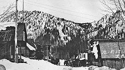
The City of Victor is a Statutory City in Teller County, Colorado, United States. Gold was discovered in Victor in the late 19th century, an omen of the future of the town. With Cripple Creek, the mining district became the second largest gold mining district in the country and realized approximately $10 billion of mined gold in 2010 dollars. It reached its peak around the turn of the century when there were about 18,000 residents in the town. Depleted ore in mines, labor strife and the exodus of miners during World War I caused a steep decline in the city's economy, from which it has never recovered. The population was 379 at the 2020 census. There is a resumed mining effort on Battle Mountain.

<span class="mw-page-title-main">Bodie, California</span> Ghost town in Mono County

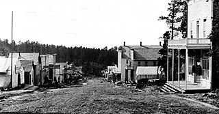
Bodie is a ghost town in the Bodie Hills east of the Sierra Nevada mountain range in Mono County, California, United States. It is about 75 miles (121 km) southeast of Lake Tahoe, and 12 mi (19 km) east-southeast of Bridgeport, at an elevation of 8,379 feet (2554 m). Bodie became a boom town in 1876 after the discovery of a profitable vein of gold; by 1879 it had established 2,000 structures with a population of roughly 8,000 people.

<span class="mw-page-title-main">Comstock Lode</span> Lode of silver ore in Virginia City, Nevada

The Comstock Lode is a lode of silver ore located under the eastern slope of Mount Davidson, a peak in the Virginia Range in Virginia City, Nevada, which was the first major discovery of silver ore in the United States and named after American miner Henry Comstock.

<span class="mw-page-title-main">Gold Point, Nevada</span> Ghost town in Nevada, United States

Gold Point, Nevada is a well-preserved historic mining town in Esmeralda County, Nevada. The community was named after the local gold-mining industry. Gold Point is the southern terminus of Nevada State Route 774. Its current population is about seven.

Eben Smith was a successful mine owner, smelting company executive, railroad executive and bank owner in Colorado in the late 19th century and early 20th century.

The Silver Valley is a region in the northwest United States, in the Coeur d'Alene Mountains in northern Idaho. It is noted for its mining heritage, dating back to the 1880s.

<span class="mw-page-title-main">Mercur, Utah</span>

Mercur is a historical hard rock mining ghost town in Tooele County, Utah, United States. In 1891, it became the site of the first successful use of the cyanide process of gold extraction in the United States, the dominant metallurgy today. Its elevation above sea level is approximately 2,042 m. The nearby Mercur Gold Mine was re-opened by Barrick Gold in 1985, with mining operations again coming to an end in 1997. The reclamation and restoration project was set to continue up to 2010.

<span class="mw-page-title-main">Burke Canyon</span> Human settlement in Idaho, United States

Burke Canyon is the canyon of the Burke-Canyon Creek, which runs through the northernmost part of Shoshone County, Idaho, U.S., within the northeastern Silver Valley. A hotbed for mining in the late-nineteenth and twentieth centuries, Burke Canyon now contains several ghost towns and remnants of former communities along Idaho State Highway 4, which runs northeast through the narrow canyon to the Montana border.

Gold mining in Colorado, a state of the United States, has been an industry since 1858. It also played a key role in the establishment of the state of Colorado.

Sterlingville was a boomtown along Sterling Creek in Jackson County, Oregon, United States, once home to the largest hydraulic mine in Oregon. It has since been abandoned and destroyed.

<span class="mw-page-title-main">Dun Glen, Nevada</span> Ghost Town in Nevada, United States

Dun Glen is a ghost town in Pershing County, Nevada, United States, 9 miles northeast of Mill City. Established in 1862, the mining camp soon became one of the largest towns in northern Nevada. By 1880, mining had declined and the town was abandoned. With a silver discovery in the area in 1908, the settlement attracted people and was re-named Chafey. Chafey was abandoned when mining operations stopped in 1913.

Ragged Top is a ghost town in Lawrence County, South Dakota, United States. While the town was once a prosperous mining town, it declined due to miners' inability to transport their ore to smelters.

<span class="mw-page-title-main">Carbonate, South Dakota</span> Town in South Dakota, United States of America

Carbonate, also known as Carbonate Camp, West Virginia, Virginia, and Carbonate City (1881-1939), is a ghost town located in Lawrence County, South Dakota, United States.

<span class="mw-page-title-main">Tinton, South Dakota</span> Ghost town in South Dakota, United States

Tinton is a ghost town in the Black Hills of Lawrence County, South Dakota, United States. It started out as a gold mining camp and later began to produce tin.

Maitland, originally called Garden City and sometimes misspelled Midland, is a ghost town in Lawrence County, South Dakota, United States. It was a mining community that boomed during the Black Hills Gold Rush, but was abandoned by about 1915.

Roubaix, formerly known as Perry or Lewisville, is an unincorporated community in Lawrence County, South Dakota, United States. It is not monitored by the U.S. Census Bureau.

The Cripple Creek Gold Rush was a period of gold production in the Cripple Creek area from the late 1800s until the early 1900s. Mining exchanges were in Cripple Creek, Colorado Springs, Pueblo and Victor. Smelting was in Gillett, Florence, and (Old) Colorado City. Mining communities sprang up quickly, but most lasted only as long as gold continued to be produced. Settlements included:

Cornucopia is an extinct town located in Elko County, Nevada. The town used to be well-known for its mining district area, which was established in 1873. Cornucopia was also known under several names, including Milltown and Kaufmanville.

<span class="mw-page-title-main">Cornucopia Peak</span> Mountain peak in Oregon, United States

Cornucopia Peak is a mountain summit located in Baker County, Oregon, US.

<span class="mw-page-title-main">Baldy Town, New Mexico</span> Mining Ghost Town

Baldy Town, New Mexico is a former mining town in the Baldy Mining District in Colfax County, New Mexico. Baldy Town was established in 1868, to service mining prospects on the East side of Baldy Mountain, notably the Aztec Mine. After Baldy Town's initial high profit boom from 1868-1870, Baldy Town suffered a series of booms and busts as investors and prospectors searched for profitable lodes. The town was originally a conglomerate of miner's homes and services in Ute Meadow. Then in 1886, Baldy Town's core was moved to a strip of services just above the Aztec Mill. The new town grew to accommodate hundreds of residents with a store, stables, saloons, boarding houses, a church, small school, and post office. In 1895, at the height of its population, Baldy Town was home to around 1,000 residents. Multiple ambitious and extensive expeditions were made from 1870-1936 to discover additional gold veins, but only a select few found substantial lodes. By 1941, Baldy Town had been deserted and a majority of its infrastructure sold. In 1963, the eastern half of Baldy Mountain, including former Baldy Town, was donated to the Boy Scouts of America by Norton Clapp. Today, Baldy Town operates as a staffed camp at Philmont Scout Ranch providing a living history program regarding mining as well as logistical support like food resupply for hikers

References

  1. Bailey, Barbara Ruth (1982). Main Street: Northeastern Oregon. Oregon Historical Society. p. 20. ISBN   0-87595-073-6.
  2. 1 2 3 4 Hall, Sharon (November 24, 2015). "Ghost Town Wednesday: Cornucopia, Oregon". digging-history.com. Retrieved March 20, 2017.
  3. 1 2 3 4 "Area History and Information". www.cornucopialodge.com. Retrieved March 20, 2017.
  4. Smith, Jim (2012). Oregon's Ghost Towns. p. 13.
  5. "Cornucopia". oregongold.net. June 17, 2011. Retrieved March 20, 2017.
  6. "CPI Inflation Calculator". bls.gov/data. Bureau of Labor Statistics . Retrieved March 28, 2021.
  7. Perry, Douglas (October 31, 2016). "Rich, even murderous, history can still be found in Oregon's ghost towns: Halloween history photos". The Oregonian . Archived from the original on August 19, 2019.
  8. 1 2 Potter, Miles F. "19". Oregon's Golden Years. Caldwell, Idaho: The Caxton Printers. ISBN   978-0-870-04254-6.
  9. "Google Maps". Google Maps. Retrieved March 22, 2017.
  10. "Cornucopia, Oregon" . Retrieved May 25, 2016.