Cow Mountain

Last updated
Cow Mountain
View over Cow Mountain.jpg
View over Cow Mountain towards Clear Lake
Highest point
Elevation 3,920 ft (1,190 m)
Prominence 1,600 ft (490 m)
Isolation 9.56 mi (15.39 km)
to  Elk Mountain
Coordinates 39°10′02″N123°03′18″W / 39.1671136°N 123.0550007°W / 39.1671136; -123.0550007 [1]
Geography
Relief map of California.png
Red triangle with thick white border.svg
Cow Mountain
Usa edcp relief location map.png
Red triangle with thick white border.svg
Cow Mountain
CountryUnited States
StateCalifornia
County Lake County
Parent range Mayacamas Mountains
Topo map Cow Mountain O39123b1 1:24,000

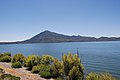
Cow Mountain is a ridge in the Mayacamas Mountains in Lake County, California, and Mendocino County, California. It is home to two large recreation areas. One is closed to off-road vehicles and the other is not. Erosion from the mountain, caused in part by human land use, contributes sediment and nutrients to Clear Lake.

Contents

Location

Cow Mountain is in the Mayacamas Mountains, part of the northern California Coast Ranges. [2] It is east of the city of Ukiah and west of the city of Lakeport. [3] It is in Lake and Mendocino counties. [4]

Cow Mountain got its name from longhorn cattle introduced around 1839 by Salvador Vallejo and later ranched by Ben Kelsey and Andrew Kelsey, which left many rogue cattle roaming the countryside. [5] When settlers arrived in the land around Clear Lake about 1853 they did not want the long horn cattle to breed with their exotic cattle bred for meat production, so began a program of shooting the long horns. Cow Mountain was one of the last refuges for the longhorns, but they had been eliminated by the 1870s by the Hurt family of Scotts Valley. [6]

Terrain

Cow Mountain is a northwest-southeast trending ridge about 7 miles (11 km) long that runs parallel to and about 1.7 miles (2.7 km) west of Cold Creek. [4] Cow Mountain is at least 3,920 feet (1,190 m) high. It has a clean prominence of 1,600 feet (490 m) and an isolation of 9.56 miles (15.39 km). The nearest higher mountain is Elk Mountain to the northeast. [2]

The southeast-plunging Ukiah-Cow Mountain Antiform (UCMA) in the hanging wall block of the Chicken Springs fault zone. This is a folded and sinuous northeast-dipping intra-Franciscan zone of thrusts that is delineated by a narrow belt of serpentinite dipping northeastward under the UCMA. [7]

Drainage

Five thousand years ago there was a massive landslide on the southern slope of Cow Mountain that filled the channel from Clear Lake to the Russian River. The lake rose, then cut a new channel through Cache Creek into the Sacramento River. [8] Cow Mountain now holds the upper reaches of the Cache Creek watershed to the east and Russian River watershed to the west. There are many year-round streams, springs and wildlife ponds. Streams in the North Cow Mountain area include Cold Creek, Howard Creek, Sulphur Creek, Mill Creek and Scotts Creek. Streams in the South Cow Mountain area include Benmore Creek, Panther Creek, Willow Creek, Lyons Valley Creek and Morrison Creek. There are many small intermittent streams and meadows. [9]

In the winter months heavy rain may cause floods and erosion, but recreational use may be a more important factor in erosion. Closure of roads and banning off-highway vehicles is thought to have significantly reduced erosion in North Cow Mountain. [9] A 1997 analysis of the South Cow Mountain trails identified some that had high potential to contribute sedimentation to Clear Lake. [10] Off-Highway Vehicle (OHV) riding in abandoned walnut orchards and creek beds has increased the rate or erosion. [11]

Environment

Climate

View from Cow Mountain after a winter storm South Cow Mountain Winter Snow (51746947963).jpg
View from Cow Mountain after a winter storm

Cow Mountain is in the Mediterranean eco-region, with wet winters and dry summers. The coldest average temperatures are 25 to 27 °F (−4 to −3 °C). Mean annual precipitation is 40 inches (1,000 mm). [12]

Vegetation

Vegetation is typical of the interior coastal mountain range. The dominant vegetation on the south and west facing slopes is chamise ( Adenostoma fasciculatum ). The more mesic northern exposures and ravines hold mixed chaparral and trees such as blue oak ( Quercus douglasii ), black oak ( Quercus kelloggii ), Douglas fir (Pseudotsuga menziesii), California nutmeg ( Torreya californica ) and California bay laurel ( Umbellularia californica ). [13] A large black oak forest covers the top and north sides of Cow Mountain. [14] There are stands of knobcone pine (Pinus attenuata) and foothill gray pine ( Pinus sabiniana ) throughout the area. [13] Non-native invasive species include yellow starthistle ( Centaurea solstitialis ), medusahead ( Taeniatherum caput-medusae ), Italian thistle ( Carduus pycnocephalus ), bull thistle ( Cirsium vulgare ), arundo ( Arundo donax ), jubata grass ( Cortaderia jubata ), scotch broom ( Cytisus scoparius ) and Harding grass ( Phalaris aquatica ). [13]

Prescribed burning of the chaparral on south facing slopes has been used to improve the habitat for deer and other wildlife by giving them access to younger and more protein-rich vegetation. [15] One estimate of the natural fire cycle in 20–40 years, while another is 35–100+ years. [16] In 1981 the Cow Mountain Fire burned about 26,000 acres (11,000 ha). [17] The headwaters of Scotts Creek on South Cow Mountain were severely burned in 2018 by the Mendocino Complex Fire, which may have increased erosion and the flow of sediments and dissolved nutrients into the Clear Lake. [18]

Tent on Cow Mountain Tent on Cow Mountain, California.jpg
Tent on Cow Mountain

The 40 acres (16 ha) Lost Valley Meadow in South Cow Mountain is an Area of Critical Environmental Concern (ACEC) with a unique assemblage of native vegetation in the Miner's Ridge watershed of the Russian River Drainage system. [19]

Fauna

Year round resident mammals include Columbian black-tail deer (Odocoileus hemionus), feral pig, western gray squirrel, brush rabbit, coyote, bobcat, cougar and raccoon. [12] The two key game species are black-tail deer and tule elk. [20] Special status species include Foothill yellow-legged frog (Rana boylii), Fisher (Martes pennati pacifica) and Western pond turtle (Emys marmorata). [12]

Bird species include wild turkey (Meleagris gallopavo), California quail (Callipepla californica), mourning dove (Zenaida macroura), California thrasher (Toxostoma redivivum), several species of woodpecker, raven, scrub jay (Aphelocoma), turkey vulture (Cathartes aura), red-tailed hawk (Buteo jamaicensis), kestrel, and various species of songbirds. [12] Migratory Birds of Conservation Concern are peregrine falcon (Falco peregrinus), prairie falcon (Falco mexicanus), burrowing owl (Athene cunicularia), long-billed curlew (Numenius americanus), rufous hummingbird (Selasphorus rufus), Lewis's woodpecker (Melanerpes lewis), olive-sided flycatcher (Contopus borealis) and Lawrence's goldfinch (Carduelis lawrencei). [21] Focal species include greater roadrunner (Geococcyx californianus), rufous-crowned sparrow (Aimophila ruficeps), sage sparrow (Amphispiza belli), and wrentit (Chamaea fasciata). [21]

Human presence

Biker in South Cow Mountain OHV Recreation Area Biker in South Cow Mountain OHV Recreation Area.jpg
Biker in South Cow Mountain OHV Recreation Area

The Cow Mountain Area was probably within the territory controlled by the Northern Pomo ethnic group. [22] The mountain probably had few residents in both the prehistoric and historic period. The Norris Trail (Nóboral-Cókadjal) ran up and over Cow Mountain from Lakeport to Ukiah, and before 1867 was one of the main routes in the area. [23] Most of the known cultural resources in the area are related to historic mining, residential and hunting activities. [24]

The Cow Mountain Management Area covers about 51,000 acres (21,000 ha) of public land. It is divided into North and South Cow Mountain. The use of weapons is limited to designated shooting areas except when hunting. [25] The recreational area is half in Lake County and half in Mendocino County. [26]

The North Cow Mountain Recreation Area covers about 26,000 acres (11,000 ha) of public land that is managed for non-motorized use. Vehicles must stay on designated routes and trails: off-highway vehicle use is not permitted. There are nearly 30 miles (48 km) of hiking, biking, and equestrian trails. Camping is allowed throughout the area, but no nearer than 300 yards (270 m) to any water source. There are two campgrounds, Mayacamas with six sites and Goat Rock with two sites. Goat Rock is only accessible by hiking or horseback. Hunting is also allowed. [3]

South Cow Mountain OHV Recreation Area covers about 23,000 acres (9,300 ha) of public land managed for off-highway vehicle use. Vehicle use is limited to 94 miles (151 km) of designated roads and trails. The area is closed during periods of precipitation, which usually occur in November. It typically opens after 72 hours with no precipitation. [27] South Cow Mountain is closed to the general public for an annual motorcycle rally. [28] Apart from erosion on the trails in South Cow Mountain, problems include vandalism, rowdiness at night, irresponsible shooters who damage signs and trees and litter the ground with shotgun shells, illegal dumping and tire burning. [11]

Notes

    1. Cow Mountain USGS.
    2. 1 2 Vitz.
    3. 1 2 North Cow Mountain Recreation Area USDI.
    4. 1 2 US Board on Geographic Names 1960, p. 17.
    5. Lundquist 2010, p. 55.
    6. Lundquist 2010, p. 56.
    7. McLaughlin et al. 2019.
    8. Witter 2017.
    9. 1 2 Ukiah Field Office 2006, p. 3-11.
    10. Lundquist 2010, p. 42.
    11. 1 2 Lundquist 2010, p. 83.
    12. 1 2 3 4 Ukiah Field Office 2016, p. 60.
    13. 1 2 3 Ukiah Field Office 2016, p. 63.
    14. Lundquist 2010, p. 50.
    15. Lundquist 2010, p. 53.
    16. Lundquist 2010, p. 70.
    17. Lundquist 2010, p. 71.
    18. Alpers.
    19. Ukiah Field Office 2016, p. 13.
    20. Ukiah Field Office 2016, p. 62.
    21. 1 2 Ukiah Field Office 2016, p. 61.
    22. Ukiah Field Office 2016, p. 51.
    23. Ukiah Field Office 2016, p. 57.
    24. Ukiah Field Office 2016, p. 58.
    25. Bureau of Land Management 2013, p. 10209.
    26. Ukiah Field Office 2016, p. 4.
    27. South Cow Mountain Recreation Area USDI.
    28. Lundquist 2010, p. 82.

    Sources

    • Alpers, Charles, Scotts Creek Nutrient Erosion Study, Lake County, California, USGS California Water Science Center, retrieved 2021-05-10
    • Bureau of Land Management (2013-02-13), "Notice of Final Supplementary Rules for Public Lands Managed by the Ukiah Field Office ...", Federal Register, 78 (30), Office of the Federal Register, National Archives and Records Service, General Services Administration, retrieved 2021-05-10
    • "Cow Mountain", Geographic Names Information System , United States Geological Survey, United States Department of the Interior , retrieved 2021-05-11
    • Lundquist, Erica (February 2010), Scotts Creek Watershed Assessment (PDF), Scotts Creek Watershed Council, retrieved 2021-05-10
    • McLaughlin, R. J.; Stanley, R. G.; Melosh, B. L.; Langenheim, V. E. (December 2019), "Neotectonic significance of Franciscan Complex bedrock structure adjacent to the Maacama Fault Zone in the Ukiah-Hopland area, northern California", American Geophysical Union, Fall Meeting 2019 (abstract), Bibcode:2019AGUFM.T23F0444M , retrieved 2021-05-10
    • North Cow Mountain Recreation Area, US Department of the Interior Bureau of Land Management, retrieved 2021-05-09
    • South Cow Mountain Recreation Area, US Department of the Interior Bureau of Land Management, retrieved 2021-05-09
    • Ukiah Field Office (2006), Resource Management Plan: Environmental Impact Statement , retrieved 2021-05-09
    • Ukiah Field Office (2016), Cow Mountain Recreation Area Implementation Plan (PDF), Bureau of Land Management, retrieved 2021-05-10
    • US Board on Geographic Names (1960), Decisions on Names in the United States, Department of the Interior, retrieved 2021-05-10
    • Vitz, John, "Cow Mountain, California", Peakbagger, retrieved 2021-05-09
    • Witter, Gene Paleno (21 January 2017), "Lake County history: The coming of man", Ukiah Daily Journal, retrieved 2021-05-10

    Related Research Articles

    <span class="mw-page-title-main">Mayacamas Mountains</span> Mountain range in northwestern California, United States

    The Mayacamas Mountains are located in northwestern California in the United States. The mountain range is part of the Northern Inner Coast Ranges, of the California Coast Ranges System.

    <span class="mw-page-title-main">Mendocino Range</span> Coastal mountain range of California, USA

    The Mendocino Range is one of several coastal mountain ranges which compose the Pacific Coast Range. This massive range of coastal mountains was formed during a period of coastal orogeny, millions of years ago. The Mendocino Range is a component of the California Coast Ranges of California. The Klamath Range is north of this region, and the Cascade Range runs to the northeast.

    <span class="mw-page-title-main">Russian River (California)</span> River in California

    The Russian River is a southward-flowing river that drains 1,485 sq mi (3,850 km2) of Sonoma and Mendocino counties in Northern California. With an annual average discharge of approximately 1,600,000 acre feet (2.0 km3), it is the second-largest river flowing through the nine-county Greater San Francisco Bay Area, with a mainstem 115 mi (185 km) long.

    <span class="mw-page-title-main">Lake Pillsbury</span> Reservoir in Lake County, California

    Lake Pillsbury is a lake in the Mendocino National Forest of Lake County, California, created from the Eel River and Hull Mountain watershed by Scott Dam. Elevation is 1,818 ft (554 m) with 65 mi (105 km) of shoreline and covering 2,003 acres (811 ha). Activities in the Lake Pillsbury Recreation Area include powerboating, fishing, swimming, sailing, picnicking, hiking and hang gliding. There are two main access roads to the lake. At the north end of the lake is a small gravel airstrip. About 400 vacation cabins including National Forest Recreational Residences ring the lake.

    <span class="mw-page-title-main">East Fork Russian River</span> River in California, United States

    East Fork Russian River is a 15 mi (24 km) long tributary of the Russian River in Mendocino County, California artificially connected to the Eel River via an interbasin diversion at the Potter Valley Project hydroelectric facility. It forms in the north of Potter Valley, flows south through this valley, then southwest through a mountain pass to Lake Mendocino, an artificial reservoir that empties into Russian River. At one time Clear Lake to the east drained through Cold Creek then along the lower part of East Fork Russian River through Coyote Valley to the Russian River proper. A few hundred years ago a massive landslide blocked this channel, and Clear Lake found a new outlet to the Sacramento River.

    <span class="mw-page-title-main">Boggs Mountain Demonstration State Forest</span> State forest in California

    Boggs Mountain Demonstration State Forest is a state forest in Lake County, California that covers the northwest of Boggs Mountain. It was founded in 1949, and came into operation in 1950 when most of the site had been clear cut. The purpose was to demonstrate good practices in restoring and managing a forest. The state forest was open for recreational use, including camping, hiking, mountain biking etc. The 2015 Valley Fire destroyed 80% of the trees. The state forest as of 2021 was replanting saplings.

    <span class="mw-page-title-main">Snow Mountain Wilderness</span> Protected wilderness area in California, United States

    The Snow Mountain Wilderness is a 60,076-acre (243.12 km2) federally designated wilderness area located 65 miles (105 km) north of Santa Rosa, California, USA in the Mendocino National Forest. The U.S. Congress passed the California Wilderness Act of 1984 which created 23 new wilderness areas including Snow Mountain. It lies within the North Coast Range of mountains.

    <span class="mw-page-title-main">Yolla Bolly–Middle Eel Wilderness</span> Protected wilderness area in California, United States

    The Yolla Bolly–Middle Eel Wilderness is a federally designated wilderness area in the Yolla Bolly Range of the southern Klamath Mountains and the Inner Northern California Coast Ranges, in Northern California.

    Smithe Redwoods State Natural Reserve is a California state park in Mendocino County. In the early 20th century, the site was purchased by Mulford Miller and W. A. S. Foster, before passing into the hands of W. S. Ware and Lester Goble in 1940. Originally a site known as Lane's Redwood Flat, the area contained cabins, a store, a post office, and a bus stop during that incarnation. In 1963, the site was proposed to be sold to a logging company, but instead entered the jurisdiction of the California Department of Parks and Recreation. The South Fork Eel River passes through the park, which contains a waterfall, as well as sites for recreation on the river and picnicking.

    <span class="mw-page-title-main">Los Guillicos Preserve</span>

    The 40-acre Los Guillicos Preserve lies in the Valley of the Moon at the foot of Hood Mountain in the Mayacamas Mountain Range. Oak woodlands of the Preserve are within the Sonoma Creek Watershed. This land was included in the 1837 Rancho Los Guilicos Mexican Land Grant. Since 2011, the Preserve has been managed by Sonoma State University's Center for Environmental Inquiry.

    <span class="mw-page-title-main">Boggs Mountain</span> Mountain in the state of California

    Boggs Mountain is a mountain the Mayacamas Mountains in Lake County, California. Part of the mountain holds the Boggs Mountain Demonstration State Forest. About 80% of the trees were burned in the September 2015 Valley Fire.

    <span class="mw-page-title-main">Kelsey Creek (Lake County)</span> Watercourse in Lake Country, California, United States

    Kelsey Creek is a watercourse in Lake County, California, United States, that feeds Clear Lake from the south. The watershed was forest-covered. In the lower parts it has been converted to farmland and for urban use. Higher up the forests have been cleared, regrown and cleared again. The northern part of the creek flows through a geothermal field that feeds power plants and hot springs. The wooded Cobb area in the higher part of the watershed holds resorts and resort communities, some dating to the 1850s.

    Cow Mountain Ridge is a ridge in Lake County, California, and Mendocino County, California. It joins Cow Mountain from the south.

    <span class="mw-page-title-main">Scotts Creek (California)</span> River in California, United States

    Scotts Creek is a stream in Lake County, California, the largest tributary of Clear Lake. It rises to the south of Cow Mountain in the Mayacamas Mountains, then flows southeast towards Clear Lake, running through the fertile Scotts Valley and the seasonal Tule Lake before joining Middle Creek and flowing into the lake via Rodman Slough.

    Mahnke Peak is a 3,652 feet (1,113 m) mountain in Mendocino County, California.

    Pyramid Ridge is a 3,520–3,560 feet (1,070–1,090 m) mountain in Mendocino County, California.

    <span class="mw-page-title-main">Cold Creek (Russian River tributary)</span> River in California, United States

    Cold Creek is a river of Mendocino County, California, a tributary of East Fork Russian River. In the past it may have connected Clear Lake to the Russian River before this route was blocked by a large landslide and Clear Lake began to drain into the Sacramento River watershed.

    <span class="mw-page-title-main">Blue Lakes (California)</span> Lakes in Lake County, California, US

    The Blue Lakes are a string of two or three lakes in Lake County, California, set in a deep canyon. At one time they seem to have been in the Russian River watershed, but a recent geological upheaval cut them off from that basin and they now drain via Scotts Creek into Clear Lake in the Sacramento River basin. In the 19th and early 20th centuries there were several resorts around the lakes. Their waters have been highly altered by human activity and most of their native fish are lost, but they have a healthy population of largemouth bass.

    <span class="mw-page-title-main">Middle Creek (Lake County, California)</span> River in California, United States

    Middle Creek is a creek that drains through Rodman Slough into Clear Lake in Lake County, California. It supplies 21% of the streamflow to Clear Lake. The watershed vegetation has been drastically modified by European settlers through sheep and cattle grazing, logging and farming in the valley floors. The creek once flowed through extensive wetlands at its mouth, but these were mainly drained to create farmland, apart from Rodman Slough on the west side. There are now projects to restore the drained land to its original condition.

    <span class="mw-page-title-main">Rivers of Lake County, California</span>

    Rivers and creeks in Lake County, California are listed below by river basin and alphabetically. Unless otherwise stated, the information is taken from the Geographic Names Information System maintained by the United States Geological Survey. Coordinates, elevations and lengths from this source are approximate.