
Pinellas County is a county located on the west central coast of the U.S. state of Florida. As of the 2020 census, the population was 959,107, which makes it the seventh-most populous county in the state. It is also the most densely populated county in Florida, with 3,491 residents per square mile. The county is part of the Tampa–St. Petersburg–Clearwater, Florida Metropolitan Statistical Area. Clearwater is the county seat. St. Petersburg is the largest city in the county, as well as the largest city in Florida that is not a county seat.

Boynton Beach is a city in Palm Beach County, Florida, United States. It is situated about 57 miles (92 km) north of Miami. The 2020 census recorded a population of 80,380. Boynton Beach is a principal city of the Miami metropolitan area, which was home to 6,138,333 people at the 2020 census. The city is named after Nathan Boynton, a Civil War major and Michigan politician who became one of the first settlers in the area in 1895. Boynton Beach is located north of Delray Beach, south of Hypoluxo and Lantana, and east of Golf, while the municipalities of Briny Breezes, Gulf Stream, Manalapan, and Ocean Ridge are situated to the east across the Intracoastal Waterway.

Lake Clarke Shores is a town in Palm Beach County, Florida, United States. The town is part of South Florida's Miami metropolitan area. The 2020 census recorded a population of 3,564.

Lake Worth Beach, previously named Lake Worth, is a city in east-central Palm Beach County, Florida, United States, located about 64 miles (103 km) north of Miami. The city's name is derived from the body of water along its eastern border known as the Lake Worth Lagoon, which was named for General William J. Worth, who led United States Army forces during the last part of the Second Seminole War. Lake Worth Beach is situated south of West Palm Beach, southeast of Lake Clarke Shores, east of Palm Springs, and north of Lantana, while a small section of the city also partitions the town of Palm Beach. The 2010 census recorded a population of 34,910, which increased to 42,219 in the 2020 census. Lake Worth Beach is within the Miami metropolitan area, which was home to an estimated 6,138,333 people in 2020.
Dunedin is a city in Pinellas County, Florida, United States. The name comes from Dùn Èideann, the Scottish Gaelic name for Edinburgh, the capital of Scotland. Dunedin is part of the Tampa-St. Petersburg-Clearwater metropolitan area and is the fifth largest city in Pinellas County. The population was 36,068 as of the 2020 census.

Palm Harbor is a census-designated place and unincorporated community in Pinellas County, Florida, United States. As of the 2016 American Community Survey, the CDP had a population of 60,236.
St. Pete Beach is a coastal city in Pinellas County, Florida. Known as a tourist destination, St. Pete Beach was formed from the towns of Pass-a-Grille, Belle Vista, St. Petersburg Beach and unincorporated Pinellas County. The population was 9,346 at the 2010 census.

The Jersey Shore is the coastal region of the U.S. state of New Jersey. Geographically, the term encompasses about 141 miles (227 km) of oceanfront bordering the Atlantic Ocean, from Perth Amboy in the north to Cape May Point in the south. The region includes Middlesex, Monmouth, Ocean, Atlantic, and Cape May counties, which are in the central and southern parts of the state. Located in the center of the Northeast Megalopolis, the northern half of the shore region is part of the New York metropolitan area, while the southern half of the shore region is part of the Philadelphia metropolitan area, also known as the Delaware Valley. The Jersey Shore hosts the highest concentration of oceanside boardwalks in the United States.
Crystal Beach is a lakefront community in Fort Erie, Ontario, Canada. As of 2016, it had a population of 8,524. It was named for the "crystal clear" water conditions present when it was founded on the northeast shore of Lake Erie, across from Buffalo.

The Emerald Coast is an unofficial name for the coastal area in the US state of Florida on the Gulf of Mexico that stretches about 100 miles (160 km) through five counties, Escambia, Santa Rosa, Okaloosa, Walton, and Bay, which include Pensacola Beach, Navarre Beach, Fort Walton Beach, Destin, and Panama City Beach. Some south Alabama communities on the coast of Baldwin County, such as Gulf Shores, Orange Beach, and Fort Morgan embrace the term as well.

State Road 30 is the mostly hidden Florida Department of Transportation designation for most of US 98 from the Florida-Alabama state line to east of Perry, Florida.

The Courtney Campbell Causeway is the northernmost bridge across Old Tampa Bay, carrying State Road 60 between Clearwater, Florida in Pinellas County and Tampa, Florida in Hillsborough County.

State Road 686 is an east–west route in Pinellas County, running from U.S. Route 19 Alternate in Largo east to an intersection with SR 687 and SR 694 in St. Petersburg, Florida. Originally, SR 686 extended further west, ending at Gulf Boulevard in Belleair Beach, next to the shores of the Gulf of Mexico.

Loxahatchee Groves is a town in Palm Beach County, Florida, United States. The town was incorporated November 1, 2006, as the 38th municipality in Palm Beach County. The first election for town council members was held on March 13, 2007. The area had been settled since 1917, although Loxahatchee Groves did not become a municipality until 2006. The town bills itself as "Florida's Last Frontier". It was incorporated primarily in order to protect the area from the encroaching urbanization of South Florida, as nearby cities continued to develop and to preserve the area's rural character. The town is part of the Miami metropolitan area. As of the 2020 US census, the town had a population of 3,355.

U.S. Highway 19 (US 19) runs about 262 miles (422 km) along Florida's west coast from an interchange with US 41 in Memphis, south of Tampa, and continues to the Georgia border north of Monticello.

U.S. Route 98 is a major east-west thoroughfare through the U.S. state of Florida. Spanning 670.959 miles (1,079.804 km), it connects Pensacola and the Alabama/Florida state line to the west with Palm Beach and the Atlantic coast in the east. It is the longest US road in Florida, as well as the longest US road in any state east of the Mississippi River.
The following is an alphabetical list of articles related to the U.S. state of Florida.

Crystal Beach Park was an amusement park in Crystal Beach, Ontario from 1888 to 1989. It was serviced by the Canadiana passenger ferry in Buffalo, making it a popular tourist destination for both Canadians and Americans.
Crystal Beach Hill is a geologically old and natural sand dune, fifty feet high and originally about two thousand feet long, parallel to the shoreline of Crystal Beach on the south-eastern shore of Lake Erie, in the town of Fort Erie, Ontario. The Hill and beach were originally a part of the Crystal Beach Park property first developed in 1888 by John E. Rebstock as a health spa, religious campground, and later amusement park that was built where a portion of the pre-historic sand dune was washed away by Rebstock's hydraulic pumps.
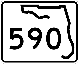
State Road 590 is an east–west commercial and commuter highway serving central Pinellas County, within Clearwater and Safety Harbor. It runs from running from Alt US 19 in Clearwater east to State Road 580 in Safety Harbor, and is a scenic route in much of Safety Harbor.
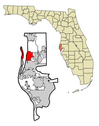
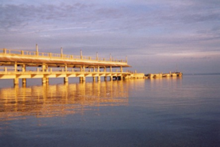
Crystal Beach Florida lies along the shore of St Joseph's Sound, just west of Palm Harbor. This beautiful little community is home to Live Oak Park and a lovely fishing pier. The Pinellas Trail runs through Crystal Beach, connecting north and south Pinellas County for bikers and those who enjoy long walks in our tropical paradise.
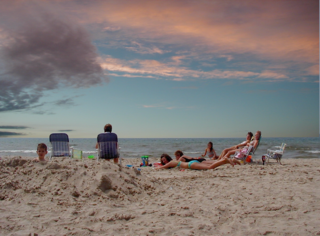
This little community is convenient to all you could possibly need, yet far enough removed from the action that you feel you are living in the Florida of the 1950s! A wonderful place to live and play in the Florida sun!


