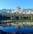
Mount Morrison is located in the Sierra Nevada, in the Sherwin Range. It rises south of Convict Lake near the town of Mammoth Lakes.

Temple Crag is a mountain peak in the Palisades group of peaks of the Sierra Nevada with an elevation of 12,982 feet (3,957 m). The peak lies east of the Sierra Crest, between Mount Gayley and Mount Alice, straddling the drainages of the North and South Forks of Big Pine Creek. The peak's north face forms the backdrop for part of the North Fork Big Pine Creek hiking trail in the John Muir Wilderness and Inyo National Forest. It is also a rock climbing destination, with its arêtes hosting the routes Venusian Blind, Moon Goddess Arete, Sun Ribbon Arete, and Dark Star.

Red and White Mountain is a remote 12,816-foot-elevation mountain summit located on the crest of the Sierra Nevada mountain range in northern California, United States. It is situated in the John Muir Wilderness on the shared boundary of Sierra National Forest with Inyo National Forest, and along the common border of Fresno County with Mono County. It is eight miles northeast of Lake Thomas A Edison, and approximately 13 miles (21 km) southeast of the community of Mammoth Lakes. The nearest higher neighbor is Red Slate Mountain, 2 miles (3.2 km) to the north-northwest.

Black Mountain is a 13,291-foot-elevation (4,051-meter) mountain summit located on the crest of the Sierra Nevada mountain range in northern California. It is situated on the common border of Fresno County with Inyo County, as well as the shared boundary of John Muir Wilderness and Kings Canyon National Park. It is 10.5 miles (16.9 km) west of the community of Independence, and 4.3 miles (6.9 km) north-northwest of parent University Peak. Black Mountain ranks as the 91st highest summit in California. Topographic relief is significant as the west aspect rises 2,750 feet above Rae Lakes in approximately one mile. The John Muir Trail traverses below the west aspect of this peak, providing an approach to the mountain. The first ascent of the summit was made in 1905 by George R. Davis, a USGS topographer. This mountain is habitat for the endangered Sierra Nevada bighorn sheep, which restricts climbing from July through December, so most ascents are made in the spring.
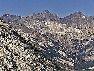
Devils Crags is a 12,424-foot-elevation (3,787-meter) mountain summit located west of the crest of the Sierra Nevada mountain range, in Fresno County of central California, United States. This jagged line of 11 pinnacles is situated at the southern end of the Black Divide in northern Kings Canyon National Park, 1.88 miles (3.03 km) south of The Citadel, and one mile southeast of Wheel Mountain, which is the nearest higher neighbor. Devils Crags ranks as the 299th highest summit in California. Topographic relief is significant as it rises 4,200 feet above Le Conte Canyon in approximately two miles. An approach to this remote peak is made possible via the John Muir Trail which passes through Le Conte Canyon, below to the east. The class 5 Northwest Arête is considered one of the classic climbing routes in the Sierra Nevada.

Mount Baldwin is a 12,614-foot-elevation (3,845-meter) mountain summit located in the Sierra Nevada mountain range in Mono County of northern California, United States. It is situated in the John Muir Wilderness on land managed by Inyo National Forest. It is four miles north of Red and White Mountain, and approximately 10.5 miles (16.9 km) southeast of the community of Mammoth Lakes. The nearest higher neighbor is Red Slate Mountain, 2 miles (3.2 km) to the south-southwest. Baldwin ranks as the 257th highest summit in California. Topographic relief is significant as the east aspect rises 3,775 feet above McGee Canyon in 1.5 mile. The first ascent of the summit was made July 2, 1928, by Norman Clyde, who is credited with 130 first ascents, most of which were in the Sierra Nevada.
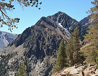
Gabbro Peak is an 11,033-foot-elevation (3,363-meter) mountain summit located in the Sierra Nevada mountain range, in Mono County of northern California, United States. The mountain is set in the Hoover Wilderness on land managed by Humboldt–Toiyabe National Forest. The peak is situated one mile outside the boundary of Yosemite National Park, approximately three miles northwest of Virginia Lakes, one-half mile north of Page Peaks, and 2.2 miles (3.5 km) west-northwest of Dunderberg Peak. Topographic relief is significant as the north aspect rises over 2,000 feet above Green Lake in one-half mile. Gabbro Peak may be climbed from East Lake, or via the Virginia Pass Trail.

Kettle Peak is a mountain with a summit elevation of 11,010 feet (3,356 m) located in the Sierra Nevada mountain range, in Mono County of northern California, United States. The summit is set in the Hoover Wilderness on land managed by Humboldt–Toiyabe National Forest, and is less than one-half mile outside the boundary of Yosemite National Park. The peak is situated approximately three miles southwest of Twin Lakes, three miles south of Victoria Peak, 2.9 miles northeast of Crown Point, and 3.1 miles northwest of Matterhorn Peak. Topographic relief is significant as the west aspect rises over 2,600 feet above Robinson Creek in one mile.
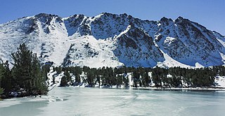
Black Mountain is an 11,797-foot-elevation (3,596 meter) summit located in the Sierra Nevada mountain range, in Mono County of northern California, United States. The mountain is set within the Hoover Wilderness, on the common boundary shared by Inyo National Forest with Humboldt–Toiyabe National Forest, and 1.5 mile outside the boundary of Yosemite National Park. The peak is situated immediately southwest above Virginia Lakes, 1.8 miles (2.9 km) northeast of line parent Excelsior Mountain, and 1.8 miles (2.9 km) south of Dunderberg Peak. Topographic relief is significant as the north aspect rises 1,500 feet above Cooney Lake in one-half mile (0.80 km), and the south aspect rises 3,600 feet above Lundy Canyon in one and a half miles (2.4 km). The first ascent of the summit was made in 1905 by George R. Davis, Albert Hale Sylvester, and Pearson Chapman, all with the United States Geological Survey.

Mount Starr, elevation 12,835 feet (3,912 m), is a mountain summit located on the crest of the Sierra Nevada mountain range in northern California, United States. It is situated in the John Muir Wilderness on the common boundary shared by Sierra National Forest with Inyo National Forest, and along the common border of Fresno County with Inyo County. It is bound on the east by Little Lakes Valley, and is 0.8 mile northeast of Mono Pass. Topographic relief is significant as the summit rises 2,300 feet above Little Lakes Valley in approximately one-half mile (0.80 km). Neighbors include Mount Abbot, three miles to the south-southwest, Mount Morgan, 2.5 miles to the southeast, and Pointless Peak is 2.5 miles to the north.

Mount Warren is a 12,327-foot-elevation (3,757 meter) summit located in the Sierra Nevada mountain range, in Mono County, California, United States. The mountain is set within the Hoover Wilderness, on land managed by Inyo National Forest. The peak is situated 1.5 miles (2.4 km) south of Gilcrest Peak, 1.8 miles (2.9 km) northwest of Lee Vining Peak, and 5 miles (8.0 km) southeast of Excelsior Mountain, which is the nearest higher neighbor. Topographic relief is significant as the summit rises 5,955 feet above Mono Lake in 4.5 miles.

Mount Crocker is a remote 12,458-foot-elevation mountain summit located on the crest of the Sierra Nevada mountain range in northern California, United States. It is situated in the John Muir Wilderness, on the boundary shared by Sierra National Forest with Inyo National Forest, and along the common border of Fresno County with Mono County. Crocker ranks as the 291st-highest summit in California. Topographic relief is significant as the north aspect rises 2,500 feet above McGee Creek in approximately one mile. It is nine miles northeast of Lake Thomas A Edison, and approximately 15 miles (24 km) southeast of the community of Mammoth Lakes.

Mount Stanford is a 12,838-foot-elevation (3,913 meter) mountain summit located on the crest of the Sierra Nevada mountain range in northern California, United States. It is situated in the John Muir Wilderness, on the boundary shared by Sierra National Forest with Inyo National Forest, and along the common border of Fresno County with Mono County. It is 10 miles northeast of Lake Thomas A Edison, and approximately 15 miles (24 km) southeast of the community of Mammoth Lakes. Topographic relief is significant as the north aspect rises 3,200 feet above McGee Creek in approximately 1.75 mile. There is another Mount Stanford in the Sierra Nevada which is named for Stanford University.

Mount Izaak Walton is a 12,077-foot-elevation (3,681 meter) mountain summit located in the Sierra Nevada mountain range in Fresno County of northern California, United States. It is situated in the John Muir Wilderness, on land managed by Sierra National Forest. Mount Izaak Walton ranks as the 404th-highest summit in California. Topographic relief is significant as the northwest aspect rises 1,800 feet above Izaak Walton Lake in approximately one mile. It is six miles northeast of Lake Thomas A Edison, and approximately 14 miles (23 km) south-southeast of the community of Mammoth Lakes. The peak is set on Silver Divide, so precipitation runoff from the north side of this mountain drains into Fish Creek which is a tributary of the San Joaquin River, and from the south slope to Mono Creek, also a tributary of the San Joaquin.

Dragon Peak is a 12,955-foot-elevation (3,949 meter) mountain summit located on the crest of the Sierra Nevada mountain range in northern California. It is situated on the common border of Fresno County with Inyo County, as well as the boundary shared by John Muir Wilderness and Kings Canyon National Park. It is 10 miles (16 km) west of the community of Independence, and 1.3 miles (2.1 km) south of Black Mountain. Dragon Peak ranks as the 161st-highest summit in California. Topographic relief is significant as the north aspect rises 1,900 feet above Dragon Lake in less than one mile. This mountain is habitat for the endangered Sierra Nevada bighorn sheep, which restricts climbing from July through December, so most ascents are made in the spring. The first ascent of the summit was made in 1920 by either Norman Clyde, or Fred Parker and J. E. Rother. The John Muir Trail traverses two miles west of this peak, providing an approach option. The mountain is so named because of the shape of its outline as seen from Rae Lakes.

Iron Mountain is an 11,149-foot-elevation (3,398 meter) summit located in the Sierra Nevada mountain range in Madera County of northern California, United States. It is situated in the Ansel Adams Wilderness, on the boundary shared by Inyo National Forest with Sierra National Forest. It is set at the south end of the Ritter Range, approximately 10 miles (16 km) west of the community of Mammoth Lakes. Devils Postpile National Monument is 4.5 miles to the east and the Minarets are three miles to the north. Precipitation runoff from the west side of this mountain drains to North Fork San Joaquin River, and from the east slope to the Middle Fork San Joaquin. Topographic relief is significant as the east aspect rises over 2,000 feet above Anona Lake in approximately one mile. There are climbing routes to the summit via the south slope and east face, and inclusion on the Sierra Peaks Section peakbagging list generates climbing interest.

Silver Peak is an 11,878-foot-elevation (3,620 meter) mountain summit located in the Sierra Nevada mountain range in Fresno County, California, United States. It is set in the John Muir Wilderness, on land managed by Sierra National Forest. Silver Peak ranks as the 455th-highest summit in California, and topographic relief is significant as the east aspect rises nearly 2,300 feet above Beetlebug Lake in approximately one mile. It is six miles (9.7 km) north of Lake Thomas A Edison, and approximately 12 miles (19 km) south of the community of Mammoth Lakes. The peak is situated on Silver Divide, two miles northwest of Graveyard Peak. The first ascent of the summit was made prior to 1937 by an unknown party. Inclusion on the Sierra Peaks Section peakbagging list generates climbing interest.
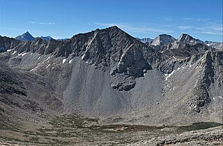
Mount Julius Caesar is a 13,213-foot-elevation mountain summit located on the crest of the Sierra Nevada mountain range in northern California, United States. It is situated in the John Muir Wilderness on the boundary that Sierra National Forest shares with Inyo National Forest, and along the common border shared by Fresno County with Inyo County. It is one mile southwest of line parent Bear Creek Spire, and 22 miles (35 km) west of the community of Bishop. Italy Pass is one-half mile immediately south of the summit, and Granite Park lies to the southeast. Mount Julius Caesar ranks as the 106th-highest summit in California. Topographic relief is significant as the summit rises 2,000 feet above Lake Italy in 0.7 miles (1.1 km).

Mount Lewis is a 12,350-foot-elevation mountain summit located along the crest of the Sierra Nevada mountain range, in Mono County of northern California, United States. It is situated in the Ansel Adams Wilderness, on land managed by Inyo National Forest. The summit lies less than one mile outside of Yosemite National Park's eastern boundary, and some of the lower western slope lies within the park. The mountain rises 1.8 miles (2.9 km) southeast of Mono Pass, 1.5 miles (2.4 km) northeast of Parker Pass, and two miles north of Parker Peak, which is the nearest higher neighbor. Topographic relief is significant as it rises over 5,200 feet above Grant Lake in four miles which makes the mountain visible from Highway 395.
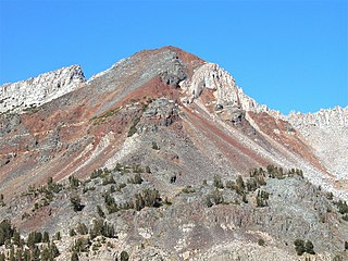
Herlihy Peak is an 11,758-foot-elevation (3,584 meter) mountain summit located in the Sierra Nevada mountain range in Mono County of northern California, United States. It is situated approximately four miles south of the community of Mammoth Lakes, in the John Muir Wilderness, on land managed by Inyo National Forest. Herlihy Peak is positioned midway between landmarks Crystal Crag and Bloody Mountain. Topographic relief is significant as the east aspect rises 2,060 feet above Valentine Lake in approximately one mile, and the west aspect rises 1,844 feet above Skelton Lake in 0.8 mile. Precipitation runoff from the peak drains to Mammoth Creek.


