Cypress Island

Last updated
Cypress Island from Rosario Strait.jpg
Cypress Island from Rosario Strait
Cypress Island locator map.svg
Cypress Island in the San Juan Islands
Geography
Location Salish Sea
Coordinates 48°34′27″N122°42′20″W / 48.57417°N 122.70556°W / 48.57417; -122.70556
Area8.6 sq mi (22 km2)
Length4.75 mi (7.64 km)
Width3.5 mi (5.6 km)
Highest elevation1,525 ft (464.8 m)
Administration
United States
State Washington
County Skagit County
Demographics
Population40 (2000)
Cypress Island from Anacortes, WA Cypress-island-washington.jpg
Cypress Island from Anacortes, WA
Map of Cypress Island Cypress Island Map.svg
Map of Cypress Island

Cypress Island is the westernmost part of Skagit County, Washington, and is about halfway between the mainland and offshore San Juan County. It is separated from Blakely Island to the west by Rosario Strait and from Guemes Island to the east by Bellingham Channel. The island has a land area of 5,500 acres (22 km2), and a population of 40 persons as of the 2000 United States Census.

Contents

The Washington Department of Natural Resources manages about 5,100 acres (21 km2) of the island and leaves the island in a natural state. Cypress is heavily forested and has a system of trails linking various parts of the island. In roughly the middle of the island is a lake of about 7 acres (28,000 m2). On the southeastern corner of the island is a sheltered bay featuring a salmon fish farm. Cypress is not served by ferry and there are no public utilities on the island.

The island is a popular destination for kayak trips due its relatively close proximity to the mainland and to the camping available at two sites on the east side.

Sheltered anchorages for boaters can be found in Eagle Harbor with public state park facilities.

Natural features

Most of the island is underlain by ultramafic rock such as serpentinite, which provides a poor balance of nutrients to soils that develop on it. The island's common soil series is Guemes very stony loam. Limited areas of fertile non-ultramafic soils occur around the island's northern end and in small pockets elsewhere. Most of these are mapped as Catla gravelly ashy sandy loam. [1]

Forests on the island are dominated by Douglas-fir. The magnesium-rich bedrock supports a considerable population of Seaside Juniper. Other common trees include shore pine, Pacific madrone and Douglas maple. Some western hemlock, western red cedar, grand fir, red alder and bigleaf maple also occur.

History

Native presence

Prior to homesteading in the early twentieth century, the island was used by the Samish tribe, which had a winter village established on nearby Guemes Island. [2] Samish fishing villages were present on Cypress until 1900. [3]

Early exploration

The first sighting of Cypress Island by Europeans was by the Spanish during the 1791 voyage of José María Narváez, who named it San Vincente. [4] The island was named again by Captain George Vancouver in early June 1792, when he mistook juniper trees for cypress trees. Vancouver reports that the Chatham, one of the vessels in his party, lost an anchor in Strawberry Bay, on the west side of the island. [5] Vancouver wrote:

The island of Cypress is principally composed of high rocky mountains and steep perpendicular cliffs which in the center of Strawberry bay fall a little back and the space between the foot of the mountains and the sea side is occupied by low marshy land through which are several small runs of most excellent water that find their way into the bay by oozing through the beach. [5]

Preservation

In 1975, the Washington Department of Natural Resources (DNR) designated 156 acres (0.63 km2) as a Natural Area Preserve, and added 56 more acres in 1978. At that time, however, most of the island remained in private hands.

Several attempts were made to develop the island. Spokane industrialist Raymond A. Hanson acquired 3,150 acres (12.7 km2) on Cypress Island in 1978 [6] and, in the 1980s proposed first a large-scale public utility development and then a five-star resort and golf-course. Small land-owners on the island, organized in a group called "Friends of Cypress Island" fought both proposals. Hanson finally sold his land to the Department of Natural Resources in 1989. [7]

This purchase along with subsequent, smaller purchases, have allowed the Natural Area Preserve to be expanded to 1,073 acres (4.34 km2), out of the 5,100 acres (21 km2) that comprise the Cypress Island Natural Resources Conservation Area.

The waters surrounding the island became a DNR Aquatic Reserve in 2007. [8] [9]

Cypress Island Panorama Small.jpg
Panorama of the San Juan Islands from Eagle Cliff on Cypress Island

See also

Related Research Articles

<span class="mw-page-title-main">Deception Pass</span> Strait between Whidbey and Fidalgo Islands on Puget Sound

Deception Pass is a strait separating Whidbey Island from Fidalgo Island, in the northwest part of the U.S. state of Washington. It connects Skagit Bay, part of Puget Sound, with the Strait of Juan de Fuca. A pair of bridges known collectively as Deception Pass Bridge cross Deception Pass. The bridges were added to the National Register of Historic Places in 1982.

<span class="mw-page-title-main">Skagit County, Washington</span> County in Washington, United States

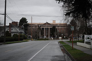
Skagit County is a county in the U.S. state of Washington. As of the 2020 census, the population was 129,523. The county seat and largest city is Mount Vernon. The county was formed in 1883 from Whatcom County and is named for the Skagit Indian tribe, which has been indigenous to the area prior to European-American settlement.

<span class="mw-page-title-main">Anacortes, Washington</span> City in Washington, United States

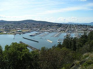
Anacortes is a city in Skagit County, Washington, United States. The name "Anacortes" is an adaptation of the name of Anne Curtis Bowman, who was the wife of early Fidalgo Island settler Amos Bowman. Anacortes' population was 17,637 at the time of the 2020 census. It is one of two principal cities of and included in the Mount Vernon-Anacortes Metropolitan Statistical Area.

<span class="mw-page-title-main">Fidalgo Island</span> Island in the Salish Sea, northwest Washington, United States

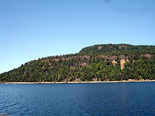
Fidalgo Island is an island in Skagit County, Washington, located about 60 mi (97 km) north of Seattle. To the east, it is separated from the mainland by the Swinomish Channel, and from Whidbey Island to the south by Deception Pass. The island is named after the Spanish explorer and cartographer Salvador Fidalgo, who explored the area in 1790.

<span class="mw-page-title-main">Guemes Island</span> Small island in the Salish Sea, northwest Washington, United States

Guemes Island is a small island in western Skagit County, Washington, United States. It is located north of Fidalgo Island and the city of Anacortes, and is accessible by private boat and by the Guemes Island ferry operated by Skagit County.

<span class="mw-page-title-main">Hornby Island</span> Island and human settlement in British Columbia, Canada

Hornby Island of British Columbia, Canada, is one of the two northernmost Gulf Islands, the other being Denman Island. It is located near Vancouver Island's Comox Valley,

The Samish are a Native American people who live in the U.S. state of Washington. They are a Central Coast Salish people. Through the years, they were assigned to reservations dominated by other Tribes, for instance, the Swinomish Indians of the Swinomish Reservation of Washington and the Tulalip Tribes of the Tulalip Reservation. They are also enrolled in the Samish Indian Nation, formerly known as the Samish Indian Tribe, which regained federal recognition in 1996.

<span class="mw-page-title-main">Padilla Bay</span> Bay in northwest Washington, United States

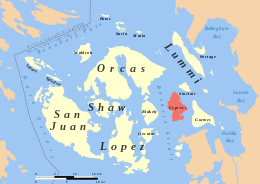
Padilla Bay is a bay located in the U.S. state of Washington, between the San Juan Islands and the mainland. Fidalgo Island and Guemes Island lie to the west of Padilla Bay. Guemes Channel, between the islands, connects Padilla Bay to Rosario Strait. Samish Island lies to the north of Padilla Bay, beyond which is Samish Bay and Bellingham Bay.

Vendovi Island is an island in the San Juan Islands of Washington State. Located in Skagit County, Washington, United States, Vendovi Island lies across Samish Bay from mainland Skagit County, between Guemes Island and Lummi Island. Vendovi Island has a land area of 220.24 acres (89.13 ha) and a population of two persons was reported as of the 2000 census. The Island was named after a Fijian High Chief Ro Veidovi who was brought to North America by the Wilkes Expedition.

<span class="mw-page-title-main">Dishman Hills</span> Mountains in Washington (state), United States

Dishman Hills Natural Resources Conservation Area is a 530-acre (210 ha) area protected by a combination of public and non-profit groups, located in Spokane County, Washington. The granite outcroppings, forming the bulk of the area, were originally formed 70 million years ago, by volcanic magma pushing up through the Earth's crust and then cooling. The protected Dishman Hills Natural Resources Conservation Area with its rugged, potholed appearance and deep gullies is a result of the Missoula Floods and represents one of the most ecologically diverse regions in Washington state, where forests, grasslands and shrublands converge and is within two ecoregions, the Okanagan and Northern Rockies ecoregions. The hills consist of small ravines, ponds, and large chunks of granite, that support an eco-system consisting mainly of ponderosa pine, as well as about 300 different flowering plants, and 73 different species of mushrooms. The area also supports wildlife, such as coyotes, marmots, white-tailed deer, pheasants, and dozens of species of butterflies. The Dishman Hills rise immediately south of the Dishman section of The City of Spokane Valley. Continuing south, out of the park, the elevation continues to rise to the Rocks of Sharon and the Iller Creek Conservation Area near the peak of Krell Hill.

<span class="mw-page-title-main">José María Narváez</span>

José María Narváez was a Spanish naval officer, explorer, and navigator notable for his work in the Gulf Islands and Lower Mainland of present-day British Columbia. In 1791, as commander of the schooner Santa Saturnina, he led the first European exploration of the Strait of Georgia, including a landing on present-day British Columbia's Sunshine Coast. He also entered Burrard Inlet, the site of present-day Vancouver, British Columbia.

The Bellingham Waterfront consists of the land along Bellingham Bay in Whatcom County, Washington, United States. It is mostly in Bellingham, Washington and other surrounding neighborhoods and cities. Various Bellingham neighborhoods are along the waterfront including is shared with Fairhaven.

<span class="mw-page-title-main">Geography of Wisconsin</span> Physical features of the state in the Midwestern United States

Wisconsin, a state in the Midwestern United States, has a vast and diverse geography famous for its landforms created by glaciers during the Wisconsin glaciation 17,000 years ago. The state can be generally divided into five geographic regions—Lake Superior Lowland, Northern Highland, Central Plain, Eastern Ridges & Lowlands, and Western Upland. The southwestern part of the state, which was not covered by glaciers during the most recent ice age, is known as the Driftless Area. The Wisconsin glaciation formed the Wisconsin Dells, Devil's Lake, and the Baraboo Range. A number of areas are protected in the state, including Devil's Lake State Park, the Apostle Islands National Lakeshore, and the Chequamegon–Nicolet National Forest.

<span class="mw-page-title-main">Puget Sound region</span> Coastal area in the U.S. state of Washington

The Puget Sound region is a coastal area of the Pacific Northwest in the U.S. state of Washington, including Puget Sound, the Puget Sound lowlands, and the surrounding region roughly west of the Cascade Range and east of the Olympic Mountains. It is characterized by a complex array of saltwater bays, islands, and peninsulas carved out by prehistoric glaciers.

<span class="mw-page-title-main">Guemes Island ferry</span> Ferry route in Skagit County, Washington, U.S.

The Guemes Island ferry, the M/V Guemes, carries passengers and vehicles across Guemes Channel between Anacortes, Washington and Guemes Island. The ferry is operated by the Skagit County Public Works Department's Ferry Division.

<span class="mw-page-title-main">Samish Indian Nation</span>

The Samish Indian Nation is a Coast Salish nation and a signatory to the Treaty of Point Elliott of 1855. Samish has a government-to-government relationship with the United States of America. The Samish are a Northern Straits branch of Central Coast Salish peoples. The Samish Nation is headquartered in Anacortes, Fidalgo Island, in Washington, north of Puget Sound.

<span class="mw-page-title-main">Swinomish Indian Tribal Community</span> Federally recognized Tribe

The Swinomish Indian Tribal Community, also known as the Swinomish Tribe, is a federally recognized Tribe located on Puget Sound in Washington, United States. They are an Indigenous people of the Pacific Northwest that includes the Central and Coast Salish peoples who lived in the Samish and Skagit River valleys, nearby coasts, and islands. The Tribe's population includes Swinomish, Lower Skagit, Upper Skagit, Kikiallus, and Samish peoples.

On August 19, 2017, a net pen at a fish farm near Cypress Island, Washington state, broke, accidentally releasing into the Pacific Ocean hundreds of thousands of non-native Atlantic salmon. The salmon farm was run by Cooke Aquaculture Pacific, LLC. According to the Washington State Department of Natural Resources, the inadequate cleaning of biofouling on the net pens containing the farmed salmon was likely the primary cause for the pen break.

<span class="mw-page-title-main">2020 Washington wildfires</span>

The 2020 Washington wildfire season officially began in March 2020. The season was a part of the 2020 Western United States wildfires. By September, wildfires had burned over 713,000 acres, 181 homes had been lost, and one death occurred as a result. The 2020 fire season saw more individual fires than in any other recorded year.

References

  1. https://casoilresource.lawr.ucdavis.edu/gmap/ Archived 2021-11-19 at the Wayback Machine SoilWeb (select Cypress Island)
  2. The Samish Tribe of Indians vs. United States Archived 2010-06-04 at the Wayback Machine , Indian Claims Commission, 1958
  3. Ruby, Robert H.; Brown, John A.; Collins, Cary (2013). A Guide to the Indian Tribes of the Pacific Northwest. University of Oklahoma Press. p. 257. ISBN   9780806189505.
  4. McDowell, Jim (1998). José Narváez: The Forgotten Explorer. Spokane, Washington: The Arthur H. Clark Company. p.  55. ISBN   0-87062-265-X.
  5. 1 2 George Vancouver (1798). A Voyage of Discovery to the North Pacific Ocean, and Round the World: In which the Coast of North-west America Has Been Carefully Examined and Accurately Surveyed : Undertaken by His Majesty's Command, Principally with a View to Ascertain the Existence of Any Navigable Communication Between the North Pacific and North Atlantic Oceans, and Performed in the Years 1790, 1791, 1792, 1793, 1794, and 1795, in the Discovery Sloop of War, and Armed Tender Chatham, Under the Command of Captain George Vancouver : in Three Volumes. G.G. and J. Robinson ... and J. Edwards. p. 297. Archived from the original on 2017-01-12. Retrieved 2016-10-07.
  6. Lonnie Rosenwald, "Spokane developer's project hits widespread opposition" [ permanent dead link ] The Spokesman-Review, Spokane, August 16, 1987
  7. Bill Deitrich, "Cypress - An Island Set Apart -- The State Finds The Best Way To Preserve Pristine Property - Buy It!" Archived 2012-09-28 at the Wayback Machine Seattle Times, July 22, 1990
  8. Cypress Island Comprehensive Management Plan Archived 2010-05-31 at the Wayback Machine , Washington Department of Natural Resources, 2007
  9. Washington State Department of Natural Resources, Cypress Island Aquatic Reserve Archived 2010-05-27 at the Wayback Machine