Dahlgren, Virginia

Last updated
Dahlgren, Virginia
King George County Virginia incorporated and unincorporated areas Dahlgren highlighted.svg
Location in King George County and the state of Virginia
Coordinates: 38°20′10″N77°3′3″W / 38.33611°N 77.05083°W / 38.33611; -77.05083 Coordinates: 38°20′10″N77°3′3″W / 38.33611°N 77.05083°W / 38.33611; -77.05083
CountryUnited States
State Virginia
County King George
Area
  Total2.80 sq mi (7.24 km2)
  Land2.69 sq mi (6.98 km2)
  Water0.10 sq mi (0.25 km2)
Elevation
20 ft (6 m)
Population
 (2010)
  Total2,653
  Density984/sq mi (380.0/km2)
Time zone UTC−5 (Eastern (EST))
  Summer (DST) UTC−4 (EDT)
ZIP codes
22448, 22485
Area code 540
FIPS code 51-21008 [1]
GNIS feature ID1465571 [2]

Dahlgren is an unincorporated community and census-designated place (CDP) in King George County, Virginia, United States. The population was 2,946 at the time of the 2020 census, [3] up from 2,653 at the 2010 census, [4] and up from 997 in 2000. [5]

Contents

History

Since 1918, Dahlgren has been the site of a U.S. naval base named for Rear Admiral John A. Dahlgren. It was first the "U.S. Naval Proving Ground" but was renamed the "U.S. Naval Weapons Laboratory" after 1950, the "Naval Surface Weapons Center" in 1974, the "Naval Surface Warfare Center" in 1987, and the "U.S. Naval Surface Warfare Center Dahlgren Division (NSWCDD)" around 1990. In 2006, it was renamed "Naval Support Activity-South Potomac (NSA-SP)", with NSWCDD becoming a tenant command of the base. The U.S. Naval Space Surveillance Systems command was located at that base, but that responsibility was transferred to the Air Force in 2004. [6] The AEGIS Training and Readiness Center is currently a tenant command at NSA-SP. The naval base lies just east of the Dahlgren CDP within its own census-designated place, Dahlgren Center.

Geography

Dahlgren is in northeastern King George County, 1 mile (1.6 km) south of and 2 miles (3 km) west of the Potomac River. It is bordered to the east by the Naval Surface Warfare Center Dahlgren Division. The Dahlgren CDP extends north to state route 635, to the west to the unincorporated community of Owens, and south to the tidal Upper Machodoc Creek, an arm of the Potomac.

U.S. Route 301 (the James Madison Parkway), runs through Dahlgren, leading northeast across the Potomac 18 miles (29 km) to La Plata, Maryland, and southwest 15 miles (24 km) to Port Royal, Virginia.

According to the United States Census Bureau, the Dahlgren CDP has a total area of 2.8 square miles (7.2 km2), of which 2.7 square miles (7.0 km2) are land and 0.10 square miles (0.25 km2), or 3.51%, are water. [4]

Demographics

As of the census [1] of 2000, there were 997 people, 456 households, and 260 families residing in the CDP. The population density was 885.2 people per square mile (340.7/km2). There were 510 housing units at an average density of 452.8/sq mi (174.3/km2). The racial makeup of the CDP was 70.31% White, 25.28% African American, 0.30% Native American, 1.50% Asian, 0.10% Pacific Islander, 0.60% from other races, and 1.91% from two or more races. Hispanic or Latino of any race were 1.71% of the population. As of the 2010 census [1] the population had more than doubled, although the makeup was largely the same, with whites edging down as a percentage from 70.31% to 61.4%, blacks up from 25.28% to 30.5%, Hispanics up from 1.71% to 4.1%, and those reporting mixed race up from 1.91% to 3.8%.

There were 456 households, out of which 24.8% had children under the age of 18 living with them, 41.2% were married couples living together, 11.0% had a female householder with no husband present, and 42.8% were non-families. 36.8% of all households were made up of individuals, and 11.4% had someone living alone who was 65 years of age or older. The average household size was 2.19 and the average family size was 2.85.

In the CDP, the population was spread out, with 23.7% under the age of 18, 7.9% from 18 to 24, 30.6% from 25 to 44, 20.9% from 45 to 64, and 17.0% who were 65 years of age or older. The median age was 37 years. For every 100 females, there were 96.6 males. For every 100 females age 18 and over, there were 95.6 males.

The median income for a household in the CDP was $49,545, and the median income for a family was $53,500. Males had a median income of $45,714 versus $21,029 for females. The per capita income for the CDP was $25,928. About 7.6% of families and 8.5% of the population were below the poverty line, including 12.7% of those under age 18 and 10.5% of those age 65 or over.

Attractions

The Dahlgren Heritage Museum is open to the public. It promotes the history, traditions, heritage, and culture of the U.S. Navy at Dahlgren, Virginia and the surrounding community. Its key holdings include a scale model of a Civil War-era Dahlgren gun, the propeller from the first radio-controlled, unmanned flight, and Norden bombsight. [7] Machodoc Creek has a full service marina. [8] The Raptor Challenge is a roadside attraction, where visitors try to locate the statues of Velociraptors along route 301. [9]

Infrastructure

The 1.7-mile-long (2.7 km), narrow two-lane Governor Harry W. Nice Memorial Bridge on U.S. Route 301 funnels interstate traffic across the wide Potomac River at Dahlgren, offering an alternative to using Interstate 95. A wider replacement bridge is scheduled for completion in 2023. Dahlgren has a growing number of small businesses along 301.

Related Research Articles

<span class="mw-page-title-main">King George County, Virginia</span> County in Virginia, United States

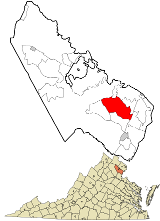
King George County is a county located in the Commonwealth of Virginia. As of the 2020 census, the population sits at 26,723. Its county seat is the town of King George.

<span class="mw-page-title-main">Warrington, Florida</span> CDP in Florida, United States

Warrington is a census-designated place (CDP) in Escambia County, Florida, United States. Warrington is located between downtown Pensacola and the state line with Alabama; it is 6 miles (10 km) away from both.

<span class="mw-page-title-main">Potomac Heights, Maryland</span> Census-designated place in Maryland, United States

Potomac Heights is a census-designated place (CDP) in Charles County, Maryland, United States. The population was 1,117 at the 2010 census. It has a volunteer fire department and numerous older rambler homes built for workers at the nearby U.S. Navy munitions plant in Indian Head.

<span class="mw-page-title-main">Potomac, Maryland</span> Census-designated place in Maryland, United States

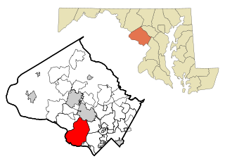
Potomac is a census-designated place (CDP) in Montgomery County, Maryland. It is named after the nearby Potomac River. Potomac is the seventh most educated small town in America, based on percentage of residents with postsecondary degrees.

<span class="mw-page-title-main">Fort Washington, Maryland</span> Census-designated place in Maryland

Fort Washington is an unincorporated area and census-designated place in Prince George's County, Maryland, United States. It borders the Potomac River, situated 20 miles south of the downtown Washington, DC. As of the 2020 census it had a population of 24,261. The Fort Washington community is located west of Maryland Route 210, with some additional area to the east of the highway.

<span class="mw-page-title-main">Melville, Rhode Island</span> CDP in Rhode Island, United States

Melville is a census-designated place (CDP) in the towns of Middletown and Portsmouth in Newport County, Rhode Island, United States. It lies along the shore of Narragansett Bay. The population of the CDP was 1,320 at the 2010 census. The CDP is named after Admiral George Wallace Melville. Past names for the area include Portsmouth Cove and Bradford.

<span class="mw-page-title-main">Belle Haven, Fairfax County, Virginia</span> Census-designated place in Virginia, United States

Belle Haven is a census-designated place (CDP) in Fairfax County, Virginia, United States. Nearby CDPs are Huntington (northwest), Groveton (southwest) and Fort Hunt (south). The population of Belle Haven was 6,518 at the 2010 census.

<span class="mw-page-title-main">Fort Hunt, Virginia</span> Census-designated place in Virginia, United States

Fort Hunt is a census-designated place (CDP) in Fairfax County, Virginia, United States. The area is named after Fort Hunt, which was built on the bank of the Potomac River in 1897 to defend Washington, D.C. from naval attack and is now a public park. The area is also notable for its high population of senior citizens and for being one of the first suburbs in wealthy Fairfax County. The population was 16,045 at the 2010 census.

<span class="mw-page-title-main">Great Falls, Virginia</span> Census-designated place in Virginia, United States

Great Falls is a census-designated place (CDP) in Fairfax County, Virginia, United States. The population as of the 2010 census was 15,427, an increase of 80.5% from the 2000 census.

<span class="mw-page-title-main">Groveton, Virginia</span> Census-designated place in Virginia, United States

Groveton is a census-designated place (CDP) in Fairfax County, Virginia, United States. The population was 14,598 at the 2010 census, down from 21,296 in 2000 due to a reduction in area. Located south of the city of Alexandria, it encompasses numerous neighborhoods including Groveton, Bucknell Manor, Stoneybrooke, and portions of Hollin Hills. Huntley Meadows Park, Fairfax County's largest park, is located in the southwest part of the CDP.

<span class="mw-page-title-main">Merrifield, Virginia</span> Census-designated place in Virginia, United States

Merrifield is a census-designated place (CDP) in Fairfax County, Virginia, United States. The population was 15,212 at the 2010 census.

<span class="mw-page-title-main">Mount Vernon, Virginia</span> Census-designated place in Virginia, United States

Mount Vernon is a census-designated place (CDP) and unincorporated community in Fairfax County, Virginia, United States. The population was 12,416 at the 2010 census. Primarily due to its historical significance and natural recreation and beauty, the Mount Vernon area receives over one million tourists each year.

<span class="mw-page-title-main">Lake Monticello, Virginia</span> Census-designated place in Virginia, United States

Lake Monticello, a private gated community, is a census-designated place (CDP) in Fluvanna County, Virginia, United States. The population was 9,920 at the 2010 census, an increase of over 44% from 2000. The community is centered on a lake of the same name, which is formed by a dam on a short tributary of the nearby Rivanna River. Lake Monticello is part of the Charlottesville Metropolitan Statistical Area. Lake Monticello was developed in the 1960s as a summer vacation home community but quickly evolved into a bedroom community of Charlottesville, and to a smaller extent of Richmond. It also has a sizable retirement age population.

<span class="mw-page-title-main">Laurel, Virginia</span> Census-designated place in Virginia, United States

Laurel is a census-designated place (CDP) in western Henrico County, Virginia. The population was 16,713 at the 2010 United States Census. It is the county seat of Henrico County.

<span class="mw-page-title-main">Fairview Beach, Virginia</span> Census-designated place in Virginia, United States

Fairview Beach is an unincorporated community and census-designated place (CDP) in King George County, Virginia, United States. The population was 391 at the 2010 census, which was up significantly from the 230 reported in 2000.

<span class="mw-page-title-main">Dale City, Virginia</span> Census-designated place in Virginia, United States

Dale City is a census-designated place (CDP) in Prince William County, Virginia, United States, located 25 miles south west of Washington, D.C. It is an annex of Woodbridge, Virginia. As of 2020, the total population was 72,088.

<span class="mw-page-title-main">Triangle, Virginia</span> Census-designated place in Virginia, United States

Triangle is a census-designated place (CDP) in Prince William County, Virginia, United States. The population was 8,188 at the 2010 census. It is bounded to the south by the Marine Corps Base Quantico, which surrounds the town of Quantico.

<span class="mw-page-title-main">Falmouth, Virginia</span> Census-designated place in Virginia, United States

Falmouth is a census-designated place (CDP) in Stafford County, Virginia, United States. Situated on the north bank of the Rappahannock River at the falls, the community is north of and opposite the city of Fredericksburg. Recognized by the U.S. Census Bureau as a census-designated place (CDP), Falmouth's population was 4,274 as of the 2010 census.

Bainbridge is a census-designated place (CDP) in Bainbridge Township, Geauga County, Ohio, United States. As of the 2010 census, the CDP had a population of 3,267.

<span class="mw-page-title-main">Naval Surface Warfare Center Dahlgren Division</span> Military unit

The United States Naval Surface Warfare Center Dahlgren Division (NSWCDD), named for Rear Admiral John A. Dahlgren, is located in King George County, Virginia, in close proximity to the largest fleet concentration area in the Navy. NSWCDD is part of the Naval Surface Warfare Centers under the Naval Sea Systems Command (NAVSEA). NSWCDD was initially established 16 October 1918 as a remote extension of Maryland's Indian Head Proving Ground used for testing naval guns. The Dahlgren site was named the Lower Station, Dahlgren Naval Proving Ground when it first opened. The location on the Potomac River was specifically chosen for the development of a long ballistic test range on the Potomac River, required for the testing of modern, high-powered munitions.

References

  1. 1 2 3 "U.S. Census website". United States Census Bureau . Retrieved 2008-01-31.
  2. "US Board on Geographic Names". United States Geological Survey. 2007-10-25. Retrieved 2008-01-31.
  3. "Explore Census Data". data.census.gov. Retrieved 2022-10-27.
  4. 1 2 "Geographic Identifiers: 2010 Census Summary File 1 (G001), Dahlgren CDP, Virginia". American FactFinder. U.S. Census Bureau. Archived from the original on February 13, 2020. Retrieved May 21, 2019.
  5. Virginia Trend Report 2: State and Complete Places (Sub-state 2010 Census Data). Archived 2012-07-11 at archive.today Missouri Census Data Center. Retrieved 2013-05-19.
  6. Wagner, Gary R. "Navy Transfers Space Surveillance Mission to Air Force". U.S. Navy. Archived from the original on 2015-01-03. Retrieved 2013-08-24.
  7. "Dahlgren Heritage Museum – Telling the Story and Reflecting the Spirit of the Navy and the Community at Dahlgren".
  8. "Machodoc Creek Marina - Marina, Boat Yard, Potomac River Fishing". Archived from the original on 2021-03-01. Retrieved 2021-03-11.
  9. "Dahlgren Raptors". www.facebook.com.