Damascus, Arkansas

Last updated

Damascus, Arkansas
Faulkner County and Van Buren County Arkansas Incorporated and Unincorporated areas Damascus Highlighted 0517290.svg
Location of Damascus in Faulkner County and Van Buren County, Arkansas.
Coordinates: 35°22′15″N92°24′30″W / 35.37083°N 92.40833°W / 35.37083; -92.40833 [1]
Country Flag of the United States.svg  United States
State Flag of Arkansas.svg  Arkansas
Counties Flag of Faulkner County, Arkansas.svg Faulkner, Van Buren
Incorporated July 15, 1966
Government
  Type Mayor-Council
Area
[2]
  Total1.86 sq mi (4.82 km2)
  Land1.86 sq mi (4.82 km2)
  Water0.00 sq mi (0.00 km2)
Elevation
[1]
696 ft (212 m)
Population
 (2020)
  Total382
  Density205.16/sq mi (79.20/km2)
Time zone UTC-6 (Central (CST))
  Summer (DST) UTC-5 (CDT)
ZIP code
72039
Area code 501
FIPS code 05-17290
GNIS ID 2406351 [1]
Website Town of Damascus

Damascus is a town in Faulkner and Van Buren counties of central Arkansas, United States. [1] [3] The population of Damascus was 382 at the 2010 census.

Contents

History

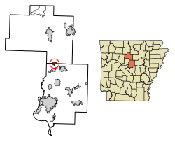
Damascus is a town located in the Ozark foothills on a plateau surrounded by clear streams along U.S. Highway 65 on the county line between Faulkner and Van Buren counties. It is most known for its proximity to the Titan II missile base that operated from 1963 until 1980, when a missile explosion killed one person and injured twenty-one. Damascus is home to three Baptist churches, a Church of Christ that was built in 1917, and a Methodist church that was built in 1947.

Damascus is also near the Gus Blass Scout Reservation, a Boy Scout Camp of 3,000 acres maintained by the Quapaw Area Council.

Broken Arrow Incident

Construction began on a Titan II missile base north of Damascus in 1961; the site became active on December 18, 1963. During routine maintenance in a Titan II silo, an Air Force repairman dropped a heavy wrench socket, which rolled off a work platform and fell toward the bottom of the silo. The socket bounced and struck the missile, causing a leak from a pressurized fuel tank. The missile complex and the surrounding area were evacuated and a team of specialists was called in from Little Rock Air Force Base, the missile's main support base. About 8 1/2 hours after the initial puncture, fuel vapors within the silo ignited and exploded. The explosion fatally injured one member of the team. Twenty-one other USAR personnel were injured. The missile's re-entry vehicle, which contained a nuclear warhead, was recovered intact. There was no radioactive contamination.

Damascus was the site of a nuclear "Broken Arrow" incident on September 18–19, 1980 when a Titan II ICBM exploded 3.3 miles (5.3 km) NNE of the town, although no radiation was spread as a result of the explosion. An extensive description of the Damascus accident can be found in Eric Schlosser’s 2013 book: Command and Control: Nuclear Weapons, the Damascus Accident, and the Illusion of Safety.

Geography

According to the United States Census Bureau, the town has a total area of 5.0 km2 (1.9 mi²), all land.

Demographics

Historical population
CensusPop.Note
1970 255
1980 30720.4%
1990 246−19.9%
2000 30624.4%
2010 38224.8%
2020 3820.0%
U.S. Decennial Census [4]

Damascus's portion within Faulkner County is in the northernmost part of the Little Rock North Little Rock Conway Metropolitan Statistical Area.

At the 2000 census there were 306 people, 137 households, and 90 families in the town. The population density was 61.2/km2 (158.3/mi²). There were 157 housing units at an average density of 31.4/km2 (81.2/mi²). The racial makeup of the town was 97.71% White, 0.98% Black or African American, 0.33% Native American, and 0.98% from two or more races. 1.31% of the population were Hispanic or Latino of any race. [5] Of the 137 households 26.3% had children under the age of 18 living with them, 53.3% were married couples living together, 7.3% had a female householder with no husband present, and 34.3% were non-families. 30.7% of households were one person and 19.0% were one person aged 65 or older. The average household size was 2.23 and the average family size was 2.81.

The age distribution was 21.2% under the age of 18, 5.9% from 18 to 24, 25.2% from 25 to 44, 21.9% from 45 to 64, and 25.8% 65 or older. The median age was 44 years. For every 100 females, there were 96.2 males. For every 100 females age 18 and over, there were 88.3 males.

The median household income was $28,977 and the median family income was $38,750. Males had a median income of $28,214 versus $16,458 for females. The per capita income for the town was $18,342. About 1.3% of families and 8.0% of the population were below the poverty line, including none of those under the age of eighteen and 22.2% of those sixty five or over.

Education

Public education for elementary and secondary school students in all parts of Damascus is available from the South Side School District. [6] [7]

Libraries

The city is served by the Faulkner-Van Buren Regional Library System, a two county library system formed in 1954. Damascus Library

Notable person

Related Research Articles

<span class="mw-page-title-main">Van Buren County, Michigan</span> County in Michigan, United States

Van Buren County is a county located in the U.S. state of Michigan. As of the 2020 Census, the population was 75,587. The county seat is Paw Paw. The county was founded in 1829 and organized in 1837.

<span class="mw-page-title-main">Van Buren County, Arkansas</span> County in Arkansas, United States

Van Buren County is a county located in the U.S. state of Arkansas. As of the 2020 census, the population was 15,796. The county seat is Clinton. The county was formed on November 11, 1833, and named for Martin Van Buren, President of the United States, who was Vice President at the time of the county's formation. Van Buren County was a dry county until November 3, 2020, as the county residents voted to make it a wet county.

<span class="mw-page-title-main">Faulkner County, Arkansas</span> County in Arkansas, United States

Faulkner County is located in the Central Arkansas region of the U.S. state of Arkansas. As of the 2020 census, the population was 123,498, making it the fifth most populous of Arkansas's 75 counties. The county seat and largest city is Conway. Faulkner County was created on April 12, 1873, one of nine counties formed during Reconstruction, and is named for Sandford C. Faulkner, better known as Sandy Faulkner, a popular figure in the state at the time.

<span class="mw-page-title-main">Crawford County, Arkansas</span> County in Arkansas, United States

Crawford County is a county located in the Ozarks region of the U.S. state of Arkansas. As of the 2020 census, the population was 60,133. The county seat and largest city is Van Buren. Crawford County was formed on October 18, 1820, from the former Lovely County and Indian Territory, and was named for William H. Crawford, the United States Secretary of War in 1815.

<span class="mw-page-title-main">Conway County, Arkansas</span> County in Arkansas, United States

Conway County is a county located in the U.S. state of Arkansas. Created as Arkansas's 11th county on October 20, 1825, Conway County has four incorporated municipalities, including Morrilton, the county seat and most populous city. The county is also the site of numerous unincorporated communities and ghost towns. The county is named for Henry Wharton Conway, a politician from a powerful political family who served as the delegate from the Arkansas Territory to the U.S. Congress from 1823 to 1827.

<span class="mw-page-title-main">Cleburne County, Arkansas</span> County in Arkansas, United States

Cleburne County is a county located in the U.S. state of Arkansas. As of the 2020 census, the population was 24,711. The county seat and most populous city is Heber Springs. The county was formed on February 20, 1883, as the last of Arkansas's 75 counties to be formed. It is named for Confederate Major-General Patrick Cleburne. Cleburne is an alcohol prohibition or dry county.

<span class="mw-page-title-main">Fairfield Bay, Arkansas</span> City in Arkansas, United States

Fairfield Bay is a city in Cleburne and Van Buren counties in the northern part of the U.S. state of Arkansas. The population was 2,108 at the 2020 census. The population in its portion in Van Buren County, which accounts for the bulk of the city limits, made the city the most populous in Van Buren County as of the 2000 census, but with a slight decline in population, lost the distinction to Clinton as of 2010.

<span class="mw-page-title-main">Dyer, Arkansas</span> City in Arkansas, United States

Dyer is a city in Crawford County, Arkansas, United States. It is part of the Fort Smith, Arkansas-Oklahoma Metropolitan Statistical Area. The population was 876 at the 2010 census.

<span class="mw-page-title-main">Van Buren, Arkansas</span> City in Arkansas, United States

Van Buren is the second-largest city in the Fort Smith, Arkansas–Oklahoma Metropolitan Statistical Area and the county seat of Crawford County, Arkansas, United States. The city is located directly northeast of Fort Smith at the Interstate 40 – Interstate 540 junction. The city was incorporated in 1845 and as of the 2020 census had a population of 23,218, ranking it as the state's 21st largest city.

<span class="mw-page-title-main">Guy, Arkansas</span> City in Arkansas, United States

Guy is a city in Faulkner County, Arkansas, United States. The population was 708 at the 2010 census, up from 202 at the 2000 census. It is part of the Central Arkansas region.

<span class="mw-page-title-main">Twin Groves, Arkansas</span> Town in Arkansas, United States

Twin Groves is a town in northwestern Faulkner County, Arkansas, United States. The name of the town comes from two neighboring communities — Solomon Grove and Zion Grove — which joined to incorporate as a town in 1991. The town's population was 335 at the 2010 census, up from 276 at the 2000 census. Twin Groves is part of the Central Arkansas region.

<span class="mw-page-title-main">London, Arkansas</span> City in Arkansas, United States

London is a city in Pope County, Arkansas, United States. The population was 1,039 at the 2010 census. It is part of the Russellville Micropolitan Statistical Area.

<span class="mw-page-title-main">Shirley, Arkansas</span> Town in Arkansas, United States

Shirley is a town in northeast Van Buren County, Arkansas, United States, along the Middle Fork of the Little Red River. A one-time railroad outpost, the community today is oriented toward agriculture and recreational activities due to the river and Greers Ferry Lake. The population was 223 at the 2010 census.

<span class="mw-page-title-main">Cantril, Iowa</span> City in Iowa, United States

Cantril is a city in Van Buren County, Iowa, United States. The population was 224 at the 2020 census.

<span class="mw-page-title-main">Farmington, Iowa</span> City in Iowa, United States

Farmington is a city in Van Buren County, Iowa, United States. The population was 579 at the time of the 2020 census.

<span class="mw-page-title-main">Van Buren, Missouri</span> City in Missouri, United States

Van Buren is a city in Carter County, Missouri, United States. It is the county seat and largest city in Carter County. Van Buren was founded in 1833 as the county seat of Ripley County and was named after then Vice President of the United States, Martin Van Buren. In 1859, Van Buren became a part of the newly created Carter County and was subsequently selected to be the county seat. The 2020 U.S. Census showed Van Buren with a population of 747.

<span class="mw-page-title-main">Antler, North Dakota</span> City in North Dakota, United States

Antler is a city in Bottineau County in the U.S. state of North Dakota. The population was 22 at the 2020 census. Antler was founded in 1905.

<span class="mw-page-title-main">Van Buren, Maine</span> Town in Maine, United States

Van Buren is a town on the Saint John River in Aroostook County, Maine, United States; located across from Saint-Leonard, New Brunswick, Canada. The population was 2,038 at the 2020 census. It is named after U.S. President Martin Van Buren.

<span class="mw-page-title-main">1980 Damascus Titan missile explosion</span> Explosion of a US ICBM in Arkansas

The Damascus Titan missile explosion was a 1980 U.S. nuclear weapons incident involving a Titan II Intercontinental Ballistic Missile (ICBM). The incident occurred on September 18–19, 1980, at Missile Complex 374-7 in rural Arkansas when a U.S. Air Force LGM-25C Titan II ICBM loaded with a 9-megaton W-53 nuclear warhead experienced a liquid fuel explosion inside its silo.

<span class="mw-page-title-main">1965 Searcy missile silo fire</span> Weapon

The 1965 Searcy missile silo fire was an uncontrolled fire inside a Titan II missile silo near Searcy, Arkansas on August 9, 1965. The fire broke out while the missile silo was being renovated and improved; the missile was installed and fueled at the time, although the nuclear warhead had been removed. Only two of the 55 workers who were inside the silo at the time survived.

References

  1. 1 2 3 4 U.S. Geological Survey Geographic Names Information System: Damascus, Arkansas
  2. "2020 U.S. Gazetteer Files". United States Census Bureau. Retrieved October 29, 2021.
  3. Local.Arkansas.gov - Damascus , retrieved September 3, 2012
  4. "Census of Population and Housing". Census.gov. Retrieved June 4, 2015.
  5. "U.S. Census website". United States Census Bureau . Retrieved January 31, 2008.
  6. "SCHOOL DISTRICT REFERENCE MAP (2010 CENSUS): Van Buren County, AR." U.S. Census Bureau. Retrieved on June 2, 2018.
  7. "SCHOOL DISTRICT REFERENCE MAP (2010 CENSUS): Faulkner County, AR" (PDF). U.S. Census Bureau . Retrieved March 17, 2021.

Further reading