Davis City, Iowa

Last updated

Davis City, Iowa
Decatur County Iowa Incorporated and Unincorporated areas Davis City Highlighted.svg
Location of Davis City, Iowa
Coordinates: 40°38′24″N93°48′45″W / 40.64000°N 93.81250°W / 40.64000; -93.81250
Country Flag of the United States.svg  United States
State Flag of Iowa.svg  Iowa
County Decatur
Area
[1]
  Total0.58 sq mi (1.50 km2)
  Land0.58 sq mi (1.50 km2)
  Water0.00 sq mi (0.00 km2)
Elevation
[2]
958 ft (292 m)
Population
 (2020)
  Total179
  Density308.09/sq mi (119.00/km2)
Time zone UTC-6 (Central (CST))
  Summer (DST) UTC-5 (CDT)
ZIP code
50065
Area code 641
FIPS code 19-19090
GNIS feature ID2394468 [2]

Davis City is a city in Decatur County, Iowa, United States. The population was 179 at the time of the 2020 census. [3]

Contents

History

Davis City was laid out in 1855. [4] It is named for William Davis, who operated a sawmill. [5] Davis City was a shipping point on the Chicago, Burlington and Quincy Railroad. [6]

Geography

Davis City is located along the Thompson River. A stream gauge station is maintained on the river in the city.

According to the United States Census Bureau, the city has a total area of 0.59 square miles (1.53 km2), all land. [7]

Demographics

Historical populations
YearPop.±%
1880 348    
1890 594+70.7%
1900 617+3.9%
1910 489−20.7%
1920 476−2.7%
1930 548+15.1%
1940 556+1.5%
1950 432−22.3%
1960 346−19.9%
1970 301−13.0%
1980 327+8.6%
1990 257−21.4%
2000 275+7.0%
2010 204−25.8%
2020 179−12.3%
Source: "U.S. Census website". United States Census Bureau . Retrieved March 29, 2020. and Iowa Data Center
Source:
U.S. Decennial Census [8] [3]
The population of Davis City, Iowa from US census data Davis CityIowaPopPlot.png
The population of Davis City, Iowa from US census data

2010 census

At the 2010 census there were 204 people in 94 households, including 53 families, in the city. The population density was 345.8 inhabitants per square mile (133.5/km2). There were 121 housing units at an average density of 205.1 per square mile (79.2/km2). The racial makup of the city was 98.0% White, 0.5% Native American, and 1.5% from two or more races. Hispanic or Latino of any race were 1.0%. [9]

Of the 94 households 21.3% had children under the age of 18 living with them, 44.7% were married couples living together, 6.4% had a female householder with no husband present, 5.3% had a male householder with no wife present, and 43.6% were non-families. 36.2% of households were one person and 17% were one person aged 65 or older. The average household size was 2.12 and the average family size was 2.72.

The median age was 52 years. 18.1% of residents were under the age of 18; 6.9% were between the ages of 18 and 24; 17.2% were from 25 to 44; 28.4% were from 45 to 64; and 29.4% were 65 or older. The gender makeup of the city was 48.5% male and 51.5% female.

2000 census

At the 2000 census there were 275 people in 109 households, including 79 families, in the city. The population density was 469.5 inhabitants per square mile (181.3/km2). There were 125 housing units at an average density of 213.4 per square mile (82.4/km2). The racial makup of the city was 98.55% White, 0.36% Native American, 0.73% from other races, and 0.36% from two or more races. Hispanic or Latino of any race were 1.45%. [10]

Of the 109 households 33.9% had children under the age of 18 living with them, 54.1% were married couples living together, 11.0% had a female householder with no husband present, and 27.5% were non-families. 24.8% of households were one person and 10.1% were one person aged 65 or older. The average household size was 2.46 and the average family size was 2.86.

The age distribution was 27.6% under the age of 18, 5.8% from 18 to 24, 25.5% from 25 to 44, 24.0% from 45 to 64, and 17.1% 65 or older. The median age was 39 years. For every 100 females, there were 99.3 males. For every 100 females age 18 and over, there were 95.1 males.

The median household income was $23,750 and the median family income was $26,875. Males had a median income of $25,750 versus $19,250 for females. The per capita income for the city was $10,091. About 25.6% of families and 28.6% of the population were below the poverty line, including 30.4% of those under the age of eighteen and 23.1% of those sixty five or over.

Education

The Central Decatur Community School District operates local area public schools. [11]

Transportation

While there is no fixed-route transit service in Davis City, intercity bus service is provided by Jefferson Lines in nearby Lamoni. [12]

Related Research Articles

<span class="mw-page-title-main">Nodaway, Iowa</span> City in Iowa, United States

Nodaway is a city in Nodaway Township, Adams County, Iowa, United States. The population was 74 at the time of the 2020 census. Nodaway was incorporated in 1900.

<span class="mw-page-title-main">Shellsburg, Iowa</span> City in Iowa, United States

Shellsburg is a city in Benton County, Iowa, United States. The population was 961 at the time of the 2020 census. It is part of the Cedar Rapids Metropolitan Statistical Area.

<span class="mw-page-title-main">Rinard, Iowa</span> City in Iowa, United States

Rinard is a city in Calhoun County, Iowa, United States. The population was 38 at the time of the 2020 census.

<span class="mw-page-title-main">Decatur City, Iowa</span> City in Iowa, United States

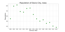
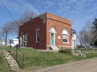
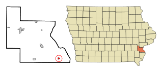
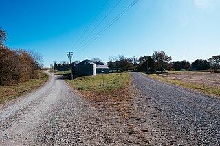
Decatur City is a city in Decatur County, Iowa, United States. The population was 175 at the time of the 2020 census.

<span class="mw-page-title-main">Grand River, Iowa</span> City in Iowa, United States

Grand River is a city in northwest Decatur County, Iowa, United States. The population was 196 at the time of the 2020 census.

<span class="mw-page-title-main">Van Wert, Iowa</span> City in Iowa, United States

Van Wert is a city in northern Decatur County, Iowa, United States. The population was 178 at the time of the 2020 census.

<span class="mw-page-title-main">Hillsboro, Iowa</span> City in Iowa, United States

Hillsboro is a city in Henry County, Iowa, United States. The population was 163 at the time of the 2020 census.

<span class="mw-page-title-main">Wyoming, Iowa</span> City in Iowa, United States

Wyoming is a city in Jones County, Iowa, United States. The population was 523 at the time of the 2020 census. It is part of the Cedar Rapids Metropolitan Statistical Area.

<span class="mw-page-title-main">Thornburg, Iowa</span> City in Iowa, United States

Thornburg is a village in Keokuk County, Iowa, United States. The population was 45 at the time of the 2020 census. Its sole enterprise is the Tri-County Community School, a public school serving grades K-12.

<span class="mw-page-title-main">Columbus City, Iowa</span> City in Iowa, United States

Columbus City is a city in western Louisa County, Iowa, United States. The population was 392 at the 2020 census. It is part of the Muscatine Micropolitan Statistical Area.

<span class="mw-page-title-main">Cotter, Iowa</span> City in Iowa, United States

Cotter is a city in western Louisa County, Iowa, United States. The population was 39 at the 2020 census. It is part of the Muscatine Micropolitan Statistical Area.

<span class="mw-page-title-main">Oakville, Iowa</span> City in Iowa, United States

Oakville is a city in southeastern Louisa County, Iowa, United States. The population was 200 at the time of the 2020 census. It is part of the Muscatine Micropolitan Statistical Area.

<span class="mw-page-title-main">Patterson, Iowa</span> City in Iowa, United States

Patterson is a city in Madison County, Iowa, United States. The population was 176 at the time of the 2020 census. It is part of the Des Moines–West Des Moines Metropolitan Statistical Area.

<span class="mw-page-title-main">Ruthven, Iowa</span> City in Iowa, United States

Ruthven is a city in Palo Alto County, Iowa, United States. The population was 725 at the time of the 2020 census.

<span class="mw-page-title-main">Maloy, Iowa</span> City in Iowa, United States

Maloy is a city in southwest Ringgold County, Iowa, United States, along the Platte River. The population was 22 at the time of the 2020 census.

<span class="mw-page-title-main">Westphalia, Iowa</span> City in Iowa, United States

Westphalia is a city in Shelby County, Iowa, United States. The population was 126 at the time of the 2020 census.

<span class="mw-page-title-main">Spring Hill, Iowa</span> City in Iowa, United States

Spring Hill is a city in Warren County, Iowa, United States. The population was 68 at the time of the 2020 census. It is part of the Des Moines–West Des Moines Metropolitan Statistical Area.

<span class="mw-page-title-main">St. Marys, Iowa</span> City in Iowa, United States

St. Marys or Saint Marys is a city in Warren County, Iowa, United States. The population was 108 at the time of the 2020 census.

<span class="mw-page-title-main">Crawfordsville, Iowa</span> City in Iowa, United States

Crawfordsville is a city in Washington County, Iowa, United States. It is part of the Iowa City, Iowa Metropolitan Statistical Area. The population was 277 at the 2020 census.

<span class="mw-page-title-main">West Chester, Iowa</span> City in Iowa, United States

West Chester is a city in Washington County, Iowa, United States. It is part of the Iowa City, Iowa Metropolitan Statistical Area. The population was 144 at the time of the 2020 census.

References

  1. "2020 U.S. Gazetteer Files". United States Census Bureau. Retrieved March 16, 2022.
  2. 1 2 U.S. Geological Survey Geographic Names Information System: Davis City, Iowa
  3. 1 2 "2020 Census State Redistricting Data". census.gov. United states Census Bureau. Retrieved August 12, 2021.
  4. Smith, Heman Conoman (1915). History of Decatur County, Iowa, and Its People, Volume 1. S. J. Clarke Publishing Company. p. 152.
  5. "Profile for Davis City, Iowa, IA". ePodunk. Retrieved February 22, 2014.
  6. Iowa Historical Record Published By the State Historical Society at Iowa City, Volumes XIII., XIV., and IV. 1897-98-99. 1899.
  7. "US Gazetteer files 2010". United States Census Bureau. Archived from the original on January 25, 2012. Retrieved May 11, 2012.
  8. "Census of Population and Housing". Census.gov. Retrieved June 4, 2015.
  9. "U.S. Census website". United States Census Bureau . Retrieved May 11, 2012.
  10. "U.S. Census website". United States Census Bureau . Retrieved January 31, 2008.
  11. "Central Decatur" (PDF). Iowa Department of Education. Retrieved July 16, 2020.
  12. "Iowa Bus Stops" . Retrieved September 28, 2023.