Middlesex County is a county located on the Middle Peninsula in the U.S. state of Virginia. As of the 2020 census, the population was 10,625. Its county seat is Saluda.

Mathews County is a county located in the U.S. state of Virginia. As of the 2020 census, the population was 8,533. Its county seat is Mathews.

Arnold, a census-designated place (CDP) in Anne Arundel County, Maryland, United States, located just outside of the state's capital, Annapolis. It is located 18.78 miles south of Baltimore, and 29.97 miles east of Washington, D.C. The population was 23,106 at the 2010 census. Neighborhoods straddle College Parkway and Maryland Route 2. Arnold is located on the scenic Broadneck Peninsula. The ZIP code is 21012. It is bordered by Severna Park to the northwest, Cape Saint Claire to the southeast, Annapolis to the southwest, and Lake Shore to the northeast.

Chesapeake Beach is a town in Calvert County, Maryland, United States. Its major attractions include the Chesapeake Beach Railway Station, the Chesapeake Beach Rail Trail, a water park, marinas, piers, and charter boat fishing. The town's population was recorded as 5,753 in the 2010 census.

Prince Frederick is an unincorporated community and census-designated place (CDP) in Calvert County, Maryland, United States. As of the 2020 census, the population of Prince Frederick was 3,226, up from 2,538 in 2010. It is the county seat of Calvert County.

Tangier is a town in Accomack County, Virginia, United States, on Tangier Island in the Chesapeake Bay. The population was 436 at the 2020 census. Since 1850, the island's landmass has been reduced by 67%. Under the mid-range sea level rise scenario, much of the remaining landmass is expected to be lost in the next 50 years and the town will likely need to be abandoned.
Tappahannock is the oldest town in Essex County, Virginia, United States. The population was 2,375 at the 2010 census, up from 2,068 at the 2000 census. Located on the Rappahannock River, Tappahannock is the county seat of Essex County. Its name comes from an Algonquian language word lappihanne, meaning "Town on the rise and fall of water" or "where the tide ebbs and flows." The Rappahannock is a tidal estuary from above this point and downriver to its mouth on Chesapeake Bay.

Irvington is a town on the Rappahannock River in Lancaster County, Virginia, United States. The population was 474 at the 2020 census. Located on a peninsula known as the Northern Neck, it has been designated a historic district.

Cape Charles is a town / municipal corporation in Northampton County, Virginia, United States. The population was 1,009 as of the 2010 Census.

The Middle Peninsula is the second of three large peninsulas on the western shore of Chesapeake Bay in Virginia. To the north the Rappahannock River separates it from the Northern Neck peninsula. To the south the York River separates it from the Virginia Peninsula. It encompasses six Virginia counties: Essex, Gloucester, King and Queen, King William, Mathews, and Middlesex. Developed for tobacco plantations in the colonial era, in the 21st century the Middle Peninsula is known for its quiet rural life, vegetable truck-farming, and fishing industry. As of the 2020 census, the Middle Peninsula was home to 92,886 people.
Stingray Point is a small community on the Chesapeake Bay near the village of Deltaville in Middlesex County, Virginia. It is located at the eastern terminus of State Route 33. It is populated by fewer than 250 full-time residents; however, during summer months that population surges as tourists and vacationers flock to Deltaville for recreation on the bay. Most of the houses on Stingray Point are cottages and weekend homes. Stingray Point is also home to Stingray Point Marina, one of the Deltaville area's many marinas.

The log canoe is a type of sailboat developed in the Chesapeake Bay region. Based on the dugout, it was the principal traditional fishing boat of the bay until superseded by the bugeye and the skipjack. However, it is most famous as a racing sailboat, and races continue to be held.

Reedville is an unincorporated community in Northumberland County in the Northern Neck region of the U.S. state of Virginia. It is located at the eastern terminus of U.S. Route 360 east of Heathsville, at the head of Cockrell's Creek on the western shore of the Chesapeake Bay.

Reedville Fishermen's Museum is located in the unincorporated town of Reedville along the western shore of the Chesapeake Bay in Northumberland County, Virginia.
Fort Howard is an unincorporated community and census-designated place in Baltimore County, Maryland, United States. The population was 303 at the 2010 census. The median age is 47.9. 52.86% are female and 47.14% are male. 58.9% are married and 41.1% are single. The average household size is 2.64.
Founded in 1886, Weems is an unincorporated community and census-designated place (CDP) in Lancaster County in the U. S. state of Virginia. It was first drawn as a CDP prior to the 2020 census.

Chesapeake Bay Interpretive Buoy System (CBIBS) is a network of observational buoys that are deployed throughout the Chesapeake Bay to observe the estuary's changing conditions and to serve as way points along the Captain John Smith Chesapeake National Historic Trail. They are maintained by the United States National Oceanic and Atmospheric Administration (NOAA). These "smart buoys" observe and record meteorological, oceanographic and water quality data which can be obtained in real-time by using mobile apps or by visiting http://buoybay.noaa.gov/. CBIBS is an operational buoy system in the Chesapeake Bay dedicated to maintaining a broad range of measurements necessary to track Bay restoration progress.
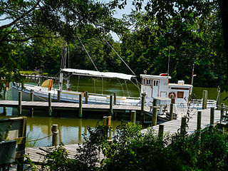
An oyster buy-boat, also known as deck boat, is an approximately 40–90 foot long wooden boat with a large open deck which serviced oyster tongers and dredgers. Similar in function to sardine carriers, buy boats circulated among the harvesters collecting their catches, then delivered their loads to a wholesaler or oyster processing house. This spared the fishermen the task and its downtime, allowing them to catch more oysters. Buy-boats also bought seed oysters, or spat, for planting in oyster beds.
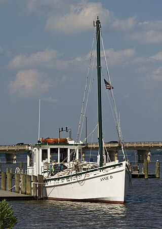
F.D. Crockett is a Poquoson-style Chesapeake Bay log-built oyster buy-boat, built in 1924 in Seaford, Virginia, by Alexander Gaines. The length of the boat is 62.8 feet (19.1 m) overall, 55.8 foot keel length, with a beam of 15.7 feet and draft of 4.6 feet. The gross tonnage is 28, net tonnage 16. The F.D. Crockett was built primarily for freight hauling and the buying and transporting of produce. She is ported at the Deltaville Maritime Museum near Deltaville, Virginia. She is on display for educational purposes and travels the Chesapeake Bay as an ambassador for the museum.
The Watermen's Museum is a museum in Yorktown, Virginia. It documents the history of Chesapeake Bay 'watermen', from pre-colonial to modern times.


