
Tierra del Fuego is an archipelago off the southernmost tip of the South American mainland, across the Strait of Magellan.
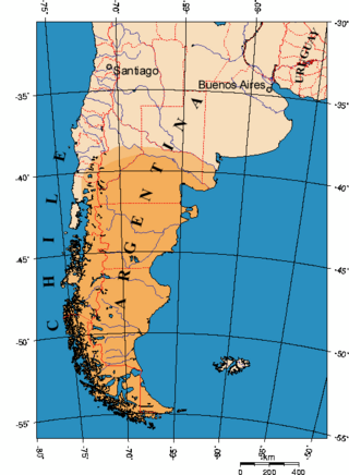
Patagonia is a geographical region that encompasses the southern end of South America, governed by Argentina and Chile. The region comprises the southern section of the Andes Mountains with lakes, fjords, temperate rainforests, and glaciers in the west and deserts, tablelands and steppes to the east. Patagonia is bounded by the Pacific Ocean on the west, the Atlantic Ocean to the east, and many bodies of water that connect them, such as the Strait of Magellan, the Beagle Channel, and the Drake Passage to the south.

The Magallanes Region, officially the Magallanes y la Antártica Chilena Region, is one of Chile's 16 first order administrative divisions. It is the southernmost, largest, and second least populated region of Chile. It comprises four provinces: Última Esperanza, Magallanes, Tierra del Fuego, and Antártica Chilena.

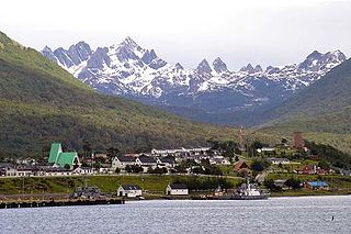
Ushuaia is the capital of Tierra del Fuego, Antártida e Islas del Atlántico Sur Province, Argentina. With a population of 82,615 and a location below the 54th parallel south latitude, Ushuaia claims the title of world's southernmost city.

Isla Grande de Tierra del Fuego also formerly Isla de Xátiva is an island near the southern tip of South America from which it is separated by the Strait of Magellan. The western portion (61.4%) of the island is in Chile, while the eastern portion is in Argentina. It forms the major landmass in an extended group of islands or archipelago also known as Tierra del Fuego.
Puerto Williams is a city, port and naval base on Navarino Island in Chile, and is also the southernmost peopled settlement in the world. It faces the Beagle Channel. It is the capital of the Chilean Antarctic Province, one of four provinces in the Magellan and Chilean Antarctica Region, and administers the communes of Chilean Antarctic Territory and Cabo de Hornos. It has a population of 2,874, including both naval personnel and civilians. Puerto Williams claims the title of world's southernmost city. The settlement was founded in 1953, and was first named Puerto Luisa. The town was later named after John Williams Wilson, a British man who founded Fuerte Bulnes, the first settlement in the Strait of Magellan. It has served primarily as a naval base for Chile. The Chilean Navy runs the Guardiamarina Zañartu Airport and hospital, as well as nearby meteorological stations. Since the late 20th century, the number of navy personnel has decreased in Puerto Williams and the civilian population has increased. In that period, tourism and support of scientific research have contributed to an increase in economic activity.

Beagle Channel is a strait in the Tierra del Fuego Archipelago, on the extreme southern tip of South America between Chile and Argentina. The channel separates the larger main island of Isla Grande de Tierra del Fuego from various smaller islands including the islands of Picton, Lennox and Nueva; Navarino; Hoste; Londonderry; and Stewart. The channel's eastern area forms part of the border between Chile and Argentina and the western area is entirely within Chile.

Nothofagus pumilio, the lenga beech, is a deciduous tree or shrub in the Nothofagaceae family that is native to the southern Andes range, in the temperate forests of Chile and Argentina to Tierra del Fuego, from 35° to 56° South latitude. This tree is in the same genus as the coihue. It regenerates easily after fires. The wood is of good quality, moderate durability, and is easy to work with. It is used in furniture, shingles and construction and sometimes as a substitute for American black cherry in the manufacturing of cabinets.

Navarino Island is a Chilean island located between Isla Grande de Tierra del Fuego, to the north, and Cape Horn, to the south. The island forms part of the Commune of Cabo de Hornos, the southernmost commune in Chile and in the world, belonging to Antártica Chilena Province in the XII Region of Magallanes and Chilean Antarctica. Its population is concentrated primarily in the communal capital, Puerto Williams, and in small settlements like Puerto Navarino, Río Guanaco and Puerto Toro. The highest point of the island is Pico Navarino at 1,195 m (3,921 ft). The island is a popular destination for fly-fishers.

Malalcahuello-Nalcas is a protected area comprising two adjoining national reserves: Malalcahuello and Nalcas. It is located in the Andes, in the Araucanía Region of Chile and bordering the Bío-Bío Region.

The Zona Austral is one of the five natural regions into which CORFO divided continental Chile in 1950 corresponding to the Chilean portion of Patagonia. It is surrounded by the Zona Sur and the Chacao Channel to the north, the Pacific Ocean and Drake's Passage to the south and west, and the Andean mountains and Argentina to the east. If excluding Chiloé Archipelago, Zona Austral covers all of Chilean Patagonia.

The Patagonian Desert, also known as the Patagonian Steppe, is the largest desert in Argentina and is the 8th largest desert in the world by area, occupying 673,000 square kilometers (260,000 mi2). It is located primarily in Argentina and is bounded by the Andes, to its west, and the Atlantic Ocean to its east, in the region of Patagonia, southern Argentina. To the north the desert grades into the Cuyo Region and the Monte. The central parts of the steppe are dominated by shrubby and herbaceous plant species albeit to the west, where precipitation is higher, bushes are replaced by grasses. Topographically the deserts consist of alternating tablelands and massifs dissected by river valleys and canyons. The more western parts of the steppe host lakes of glacial origin and grades into barren mountains or cold temperate forests along valleys.

The Patagonian chinchilla mouse is a species of rodent in the family Cricetidae. It was first described by George Robert Waterhouse in 1839. It is found in Tierra del Fuego and neighboring areas of southernmost Argentina and Chile.
The Patagonian Expedition Race is an annual endurance adventure race that takes place in the remote wilderness of Chilean Patagonia, run to help protect and raise awareness about the fragile environment in this region. Known as the 'Race to the End of the World', the 10-day event challenges co-ed international teams of four athletes in the disciplines of trekking, sea kayaking, orienteering, and mountain biking. The race takes place on a different course each year, with competitors using a map and compass to navigate through previously unknown terrain. Due to its challenging nature, it is also known as 'The Last Wild Race', and has been described as 'The World's toughest adventure race' and the ‘Dakar’ of adventure racing. The 13th edition of the race took place from 17 to 30 November 2018.

Yendegaia Bay is a bay in the Beagle Channel, in the southern coast of the Chilean part of Isla Grande de Tierra del Fuego. The bay is at the mouth of Yendegaia River and the only settlement on its shores is Caleta Ferrari.

The Martial Mountains are a mountain range in Isla Grande de Tierra del Fuego, an island of Argentina and Chile. The mountain range is located east of Cordillera Darwin, just north of Ushuaia city in Argentina, along the Beagle Channel strait.

Tierra del Fuego National Park is a national park on the Argentine part of the island of Tierra del Fuego, within Tierra del Fuego Province in the ecoregion of Patagonic Forest and Altos Andes, a part of the subantarctic forest. Established on 15 October 1960 under the Law 15.554 and expanded in 1966, it was the first shoreline national park to be established in Argentina.
The governments of Chile and Argentina are attempting to eradicate the North American beaver in the Tierra del Fuego area at the southernmost tip of South America. This non-native species was introduced in 1946 as a potential source of commercial fur trading. When the putative fur trade industry failed, the beavers became problematic and the governments agreed to intervene to wipe them out. A June 2011 NPR report stated that the beavers have caused millions of dollars in damages. According to Nature, this plan is the largest eradication project ever attempted.

The Argentina–Chile border is the longest international border of South America and the third longest in the world after the Canada–United States border and the Kazakhstan–Russia border. With a length of 5,308 kilometres (3,298 mi), it separates Argentina from Chile along the Andes and on the islands of Tierra del Fuego. However, there are some border disputes, particularly around the Southern Patagonian Ice Field. It is the largest border of the two countries, beating the Argentina–Paraguay and Chile–Bolivia, Argentina's and Chile's second largest borders, respectively.
Fueguino is a volcanic field in Chile. The southernmost volcano in the Andes, it lies on Tierra del Fuego's Cook Island and also extends over nearby Londonderry Island. The field is formed by lava domes, pyroclastic cones, and a crater lake.
