District Department of Transportation

Last updated

District Department of Transportation
DDOT.svg
Agency overview
FormedMay 2002
Preceding agency
Jurisdiction District of Columbia
Headquarters250 M Street SE, Washington, D.C. 20003
Mottod. delivers [1]
Employees1246 (fiscal 2023)
Annual budget$127.838 million (fiscal 2009) [2]
Agency executive
  • Sharon Kershbaum, Interim Director
Website ddot.dc.gov

The District Department of Transportation (DDOT, stylized as d.) is an agency of the government of the District of Columbia, in the United States, which manages and maintains publicly owned transportation infrastructure in the District of Columbia. DDOT is the lead agency with authority over the planning, design, construction, and maintenance of alleys, bridges, sidewalks, streets, street lights, and traffic signals in the District of Columbia. [3]

Contents

History

Historical documents refer to the entity now known as DDOT as the "D.C. Department of Highways" in the 1940s and 50s, [4] and later the "D.C. Department of Highways and Traffic" through the 1960s and early 70s.

In August 1975, the department merged with the Department of Motor Vehicles and the Office of the Mayor's Transportation Systems Coordinator to become the D.C. Division of Transportation, a subunit of the D.C. Department of Public Works (DPW). [5] [6] [7] The division began suffering from significant deficiencies in the 1990s, including an over-reliance on outside contractors, a lack of expertise with which to oversee contractors and ensure performance and quality work, severe understaffing, and excessive lead times for the letting and implementing of design and construction contracts. [6] These issues led to significant backlogs in maintenance and construction, and hundreds of millions of dollars in federal funds were unexpended. [6]

In response to the impending management crisis in its transportation division, in May 2002, the Council of the District of Columbia passed the District Department of Transportation Establishment Act of 2002 (D.C. Law 14-137), which separated the Division of Transportation from the Department of Public Works and created a standalone D.C. Department of Transportation (DDOT). [7] [8] A 2004 assessment indicated that the reorganization led to significant improvements in the District of Columbia's oversight of its transportation infrastructure. [7]

Operations

A DDOT snowplow in Dupont Circle, following the 2009 North American blizzard. P Street - snow removal.JPG
A DDOT snowplow in Dupont Circle, following the 2009 North American blizzard.

DDOT is led by a Director who is assisted by a Chief of Staff, Deputy Director for Operations, and Deputy Director for Resource Allocation. [9]

The most recent director was Everett Lott, who recently left DDOT. Five operational departments oversee DDOT's main functions: the Infrastructure Project Management Administration (IPMA), the Mass Transit Administration (MTA), the Transportation Policy & Planning Administration (TPPA), the Transportation Operations Administration (TOA), and the Urban Forestry Administration (UFA). [9] Four administrative offices (Communication, Information Technology, Contracting and Procurement, and Legal) provide managerial support. [9]

DDOT coordinates a number of programs with other city and regional agencies. DDOT shares street and sidewalk snow removal with the Department of Public Works, and coordinates a reduced-fare program for elementary and secondary school students with MetroBus and MetroRail. [3] Because of the heavy regional integration of the District's transportation system with other local, county, state, and federal governments, DDOT's Transportation Policy and Planning Administration coordinates policy with the Washington Metropolitan Area Transit Authority (WMATA) and the Metropolitan Washington Council of Governments' regional transportation planning and policy bodies. [10] DDOT also works closely with the District of Columbia Emergency Management Agency, Metropolitan Washington Council of Governments, the State of Maryland, the Commonwealth of Virginia, and the U.S. federal government to plan and implement the Regional Emergency Coordination Plan (which provides for emergency evacuation of the District of Columbia and surrounding areas in case of a major event, natural disaster, or military or terrorist attack). [11]

DDOT's headquarters was located at 55 M Street SE on top of the Navy Yard Metro station until April 2021. Currently DDOT's headquarters is located at 250 M Street SE.

Funding and current projects

DDOT logo on a DC Circulator bus. D-dot logo - circulator bus.jpg
DDOT logo on a DC Circulator bus.

As of 2004, all of the District's bridges and approximately 30 percent of its roads were eligible for funding from the Federal Highway Administration (FHWA). [7] The remaining roads were maintained solely with D.C. government funds. [7]

DDOT is engaged in a number of critical transportation initiatives, many of which focus on economic development in the city's poorer neighborhoods. Among DDOT's major initiatives are:

  • DC Streetcar - DDOT owns and is currently the sole financier of DC Streetcar, a surface light rail and streetcar network under construction in Washington, D.C. [12]
  • Great Streets Initiative - DDOT is a lead agency in the District of Columbia's Great Streets Initiative, which seeks to revitalize critical transportation and retail corridors throughout the city to spur economic development. [13] Current Great Streets projects include Brentwood Road NE, H Street NE, Kenilworth Avenue NE, New York Avenue, Pennsylvania Avenue SE, and South Capitol Street.
  • DC Circulator - DDOT owns the DC Circulator bus system, a downtown circulator bus system. [14] The Washington Metro manages the Circulator's operations, while a contractor (First Transit) operates the system. [14] DDOT and Metro fund the Circulator in cooperation with D.C. Surface Transit Inc. (a nonprofit conglomerate that includes the Downtown Business Improvement District, Georgetown Business Improvement District, Golden Triangle Business Improvement District, Capitol Hill Business Improvement District, Washington Convention Center Authority, and the Washington, D.C. Convention and Tourism Corporation). [14]
  • 11th Street Bridges - DDOT is replacing both spans of the 11th Street Bridges with three new bridges at a cost of $365 million. [15] The project is the biggest construction effort ever undertaken by DDOT. [16]

Statistics

The District Department of Transportation is responsible for: [10]

Directors

NameTenure
Sharon Kershbaum9/29/2023 - present
Everett Lott2/5/2021 [17] -9/29/23
Jeffrey Marootian8/11/2017 [18] -2/4/2021
Leif A. Dormsjo1/2/2015 [19] -8/10/2016
Matthew T. Brown5/2/2014 [20] -1/1/2015
Terry Bellamy1/2/2011 [21] -5/1/2014
Gabe Klein2/1/2009 [22] -1/1/2011
Frank Seales, Jr (interim)8/1/2008 [23] -1/31/2009
Emeka Monome1/2/2007 [24] -7/31/2008
Michelle L. Pourciau2/11/2006 [25] -1/1/2007
Daniel M. Tangherlini5/20/2002 [26] -2/10/2006

See also

Related Research Articles

<span class="mw-page-title-main">14th Street bridges</span> 3 bridges across the Potomac River connecting Arlington, VA and Washington, D.C., USA

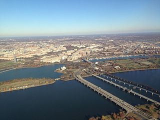
The 14th Street bridges refers to the three bridges near each other that cross the Potomac River, connecting Arlington, Virginia and Washington, D.C. Sometimes the two nearby rail bridges are included as part of the 14th Street bridge complex. A major gateway for automotive, bicycle and rail traffic, the bridge complex is named for 14th Street, which feeds automotive traffic into it on the D.C. end.

<span class="mw-page-title-main">Interstate 395 (Virginia–District of Columbia)</span> Interstate Highway in the DC area

Interstate 395 (I-395) in Washington, D.C., and Virginia is a 13.79-mile-long (22.19 km) spur route of I-95 that begins at an interchange with I-95 in Springfield and ends at an interchange with US Route 50 (US 50) in Northwest Washington, D.C. It passes underneath the National Mall near the US Capitol and ends at a junction with US 50 at New York Avenue, roughly one mile (1.6 km) north of the 3rd Street Tunnel. Despite its proximity to I-395 in Maryland, the route is unrelated and unconnected.

<span class="mw-page-title-main">Theodore Roosevelt Bridge</span> Bridge in D.C. and the Rosslyn section of Arlington, Virginia

The Theodore Roosevelt Bridge is a bridge crossing the Potomac River which connects Washington, D.C., with the Commonwealth of Virginia. The bridge crosses over Theodore Roosevelt Island, and carries Interstate 66/U.S. Route 50. The center lane in the bridge is reversible; the middle barrier is moved with a barrier transfer machine. It's operated eastbound during the morning rush hour from 6-11 am. The bridge is named in honor of Theodore Roosevelt, the 26th President of the United States.

<span class="mw-page-title-main">Interstate 695 (District of Columbia)</span> Interstate Highway in the DC area

Interstate 695 (I-695) is a two-mile-long (3.2 km) auxiliary Interstate Highway in Washington DC. It is also known as the Southeast Freeway. It travels from an interchange with I-395 south of the US Capitol building east then south across the 11th Street Bridges to an intersection with I-295 and District of Columbia Route 295 (DC 295) in Anacostia.

<span class="mw-page-title-main">New York Avenue (Washington, D.C.)</span>

New York Avenue is a diagonal avenue radiating northeast from the White House in Washington, D.C. to the border with Maryland. It is a major east–west route in the city's Northwest and Northeast quadrants and connects downtown with points east and north of the city via Cheverly, Maryland, the John Hanson Highway, the Baltimore–Washington Parkway, and eventually, Interstate 95.

<span class="mw-page-title-main">Whitney Young Memorial Bridge</span> Bridge in D.C., U.S.

The Whitney Young Memorial Bridge is a bridge that carries East Capitol Street across the Anacostia River in Washington, D.C. in the United States. Finished in 1955, it was originally called the East Capitol Street Bridge. It was renamed for civil rights activist Whitney Young in early 1974. The bridge is 1,800 feet (550 m) long, its six lanes are 82 feet (25 m) wide, and it has 15 spans resting on 14 piers.

<span class="mw-page-title-main">John Philip Sousa Bridge</span> Bridge in Washington, D.C., United States

The John Philip Sousa Bridge, also known as the Sousa Bridge and the Pennsylvania Avenue Bridge, is a continuous steel plate girder bridge that carries Pennsylvania Avenue SE across the Anacostia River in Washington, D.C., in the United States. The bridge is named for famous United States Marine Band conductor and composer John Philip Sousa, who grew up near the bridge's northwestern terminus.

<span class="mw-page-title-main">11th Street Bridges</span> Complex of three bridges across the Anacostia River in Washington, D.C.

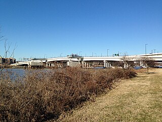
The 11th Street Bridges are a complex of three bridges across the Anacostia River in Washington, D.C., United States. The bridges convey Interstate 695 across the Anacostia to its southern terminus at Interstate 295 and DC 295. The bridges also connect the neighborhood of Anacostia with the rest of the city of Washington.

<span class="mw-page-title-main">Detroit Department of Transportation</span> Public transportation agency in Detroit, Michigan

The Detroit Department of Transportation is the primary public transportation operator serving Detroit, Michigan. In existence since 1922, DDOT is a division of the city government, headed by a director appointed by the mayor. Primarily serving Detroit and its enclaves, DDOT is supplemented by suburban service from the Suburban Mobility Authority for Regional Transportation (SMART). In 2022, the system had a ridership of 9,425,700, or about 35,800 per weekday as of the second quarter of 2023.

<span class="mw-page-title-main">DC Circulator</span> Bus system in Washington, D.C

The DC Circulator is a bus system in Washington, D.C. The District of Columbia Department of Transportation operates the service in a public–private partnership with RATP Dev.

<span class="mw-page-title-main">Barney Circle</span> Neighborhood in the United States

Barney Circle is a small residential neighborhood located between the west bank of the Anacostia River and the eastern edge of Capitol Hill in southeast Washington, D.C., in the United States. The neighborhood is characterized by its sense of community, activism, walkability, and historic feel. The neighborhood's name derives from the eponymous former traffic circle Pennsylvania Avenue SE just before it crosses the John Philip Sousa Bridge over the Anacostia. The traffic circle is named for Commodore Joshua Barney, Commander of the Chesapeake Bay Flotilla in the War of 1812.

<span class="mw-page-title-main">DC Streetcar</span> Streetcar system in Washington, D.C.

The DC Streetcar is a surface streetcar network in Washington, D.C. As of 2017, it consists of only one line: a 2.2-mile (3.5 km) segment running in mixed traffic along H Street and Benning Road in the city's Northeast quadrant.

<span class="mw-page-title-main">QLine</span> Streetcar system in Detroit, Michigan

The QLine, originally known as M-1 Rail by its developers, is a 3.3-mile-long (5.3 km) streetcar system in Detroit, Michigan, United States. Opened on May 12, 2017, it connects Downtown Detroit with Midtown and New Center, running along Woodward Avenue (M-1) for its entire route. The system is operated by M-1 Rail, a nonprofit organization.

<span class="mw-page-title-main">Transportation in metropolitan Detroit</span>

Transportation in metropolitan Detroit comprises an expansive system of roadways, multiple public transit systems, a major international airport, freight railroads, and ports. Located on the Detroit River along the Great Lakes Waterway, Detroit is a significant city in international trade, with two land crossings to Canada. Three primary Interstate highways serve the region.

<span class="mw-page-title-main">Martin Luther King Jr. Avenue</span> Street in District of Columbia, USA

Martin Luther King Jr. Avenue is a major street in the District of Columbia traversing through both the Southwest and Southeast quadrants.

<span class="mw-page-title-main">Federal-Aid Highway Act of 1968</span>

The Federal-Aid Highway Act of 1968 is legislation enacted by the United States Congress and signed into law on August 24, 1968, which expanded the Interstate Highway System by 1,500 miles (2,400 km); provided funding for new interstate, primary, and secondary roads in the United States; explicitly applied the environmental protections of the Department of Transportation Act of 1966 to federal highway projects; and applied the Davis–Bacon Act to all highway construction funded by the federal government. It established three new programs: a National Bridge Inspection Program, funding and fair housing standards for those displaced by federally funded highway construction, and a traffic operations study program.

<span class="mw-page-title-main">Three Sisters Bridge</span>

The Three Sisters Bridge was a planned bridge over the Potomac River in Washington, D.C., with piers on the Three Sisters islets. Envisioned in the 1950s and formally proposed in the 1960s, it was cancelled amid protests in the 1970s.

<span class="mw-page-title-main">Gabe Klein</span>

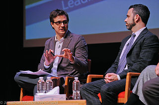
Gabe Klein is an entrepreneur, author, investor and former government official. Klein was Commissioner of the Chicago Department of Transportation (CDOT) from May 16, 2011 to December, 2013. He was appointed to this position by Mayor Rahm Emanuel when he took office on May 16, 2011. Klein was also the Director of the District of Columbia Department of Transportation (DDOT) from the end of 2008 until the end of Mayor Adrian Fenty's term, December 31, 2010. Prior, Klein was an Executive with Boston-based Zipcar. He recently authored a book titled Start-Up City: Inspiring Private and Public Entrepreneurship, Getting Projects Done, and Having Fun published by Island Press

<span class="mw-page-title-main">H Street/Benning Road Line</span> DC Streetcar line

The H Street/Benning Road Line is a currently operating line of DC Streetcar. It has eight stations and began operation on February 27, 2016. The 2.4-mile (3.9 km) line runs along H Street NE and Benning Road NE in Washington, D.C. In September 2016 service was increased from six days a week to seven, and with shorter 12-minute headways.

<span class="mw-page-title-main">Anacostia Line</span>

The Anacostia Line is a partially constructed line of the DC Streetcar, never put into service, intended to connect the Anacostia neighborhood with Joint Base Anacostia–Bolling. Construction occurred in 2009 and 2010, but was terminated before the line was complete.

References

  1. "Swoosh and Tagline". Department Branding Guidelines. District Department of Transportation. Retrieved August 10, 2016.
  2. FY 2015 Proposed Budget and Financial Plan. Volume 1: Executive Summary. 2014. Archived November 29, 2014, at the Wayback Machine
  3. 1 2 "About DDOT." District of Columbia Department of Transportation. No date. Archived January 8, 2010, at the Wayback Machine Accessed 2010-01-08
  4. "Library Record P 6025: A preliminary report on highway, parking, and related traffic problems". Historical Society of Washington, D.C. Retrieved April 29, 2019.
  5. "The D.C. Freeway Revolt and the Coming of Metro" (PDF). Federal Highway Administration . Retrieved April 29, 2019.
  6. 1 2 3 Ungar, Bernard L. Restructuring of the District of Columbia Department of Public Works' Division of Transportation. GAO-01-347R. Washington, D.C.: United States General Accounting Office, March 16, 2001. Accessed 2010-01-08
  7. 1 2 3 4 5 Goldstein, Mark L. District of Columbia's Department of Transportation's Reorganization and Use of Federal-Aid Funding. GAO-04-644R. Washington, D.C.: United States General Accounting Office, May 14, 2004. Accessed 2010-01-08
  8. Kovaleski, Serge F. "Uneven Progress Marks Williams's Busy Term." The Washington Post. September 1, 2002.
  9. 1 2 3 "Organizational Chart." District of Columbia Department of Transportation. No date. Archived December 28, 2009, at the Wayback Machine
  10. 1 2 "Transportation System Overview". District of Columbia Department of Transportation. No date. Archived December 28, 2009, at the Wayback Machine Accessed 2010-01-08
  11. "Emergency Preparedness." District of Columbia Department of Transportation. No date. Archived January 8, 2010, at the Wayback Machine Accessed 2010-01-08
  12. O'Connell, Jonathan. "Streetcar Backers Gather Ammo to Sway Skeptics." Washington Business Journal. November 27, 2009; Layton, Lyndsey. "D.C. to Study 2.7-Mile Light-Rail Line in Anacostia." Washington Post. July 4, 2003.
  13. Krouse, Sarah. "City Planners Want to Make Gateway Avenues More Attractive." Washington Business Journal. November 16, 2009.
  14. 1 2 3 O'Connell, Jonathan. "New Transit Board Would Manage Streetcars." Washington Business Journal. January 4, 2010.
  15. Thomson, Robert. "D.C. to Rebuild 11th Street Bridges over Anacostia." Washington Post. April 24, 2009; Craig, Tim. "11th Street Bridge Plans Gets Go-Ahead." Washington Post. September 22, 2009.
  16. Niedowski, Erika. "DDOT Starts Construction on 11th Street Bridge Project, Sort Of." Washington City Paper. December 29, 2009.
  17. Mayor's Order 2021-17.
  18. Mayor's Order 2017-188.
  19. Mayor's Order 2015-11.
  20. Mayor's Order 2014-93.
  21. Mayor's Order 2011-27. https://dcregs.dc.gov/Common/NoticeDetail.aspx?NoticeId=N0006273
  22. Mayor's Order 2009-23.
  23. Mayor's Order 2008-116. https://dcregs.dc.gov/Common/NoticeDetail.aspx?noticeId=N0003299
  24. Mayor's Order 2007-5.
  25. Mayor's Order 2006-22. https://dcregs.dc.gov/Common/NoticeDetail.aspx?NoticeId=N0006698
  26. Mayor's Order 2002-102.

38°55′1.9″N77°1′56.4″W / 38.917194°N 77.032333°W / 38.917194; -77.032333