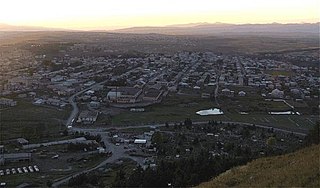
Akhalkalaki is a town in Georgia's southern region of Samtskhe–Javakheti and the administrative centre of the Akhalkalaki Municipality. Akhalkalaki lies on the edge of the Javakheti Plateau. The city is located about 29 kilometres (18 mi) from the border with Armenia. The town's recorded history goes back to the 11th century. As of the 2014 Georgian census the town had a population of 8,295, with 93.8% Armenian majority.

The history of the Jews in Armenia is one of the Jewish communities in the Caucasus region. There is evidence of Jewish settlement in the Armenian Highlands dating as early 1st century BC.
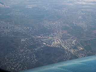
Sharur is a city in the Nakhchivan Autonomous Republic of Azerbaijan. It is the administrative centre of the Sharur District. The city is located 66 km northwest of Nakhchivan city, on the Sharur plain.
The following is a summary of censuses carried out in the Soviet Union:

The Baku Governorate, known before 1859 as the Shemakha Governorate, was a province (guberniya) of the Caucasus Viceroyalty of the Russian Empire, with its center in the booming metropolis and Caspian Sea port of Baku. Area (1897): 34,400 sq. versts, population (1897): 789,659. The Baku Governorate bordered Persia to the south, the Elizavetpol Governorate to the west, the Dagestan Oblast to the north, and the Baku gradonachalstvo to the east on the Absheron Peninsula.

The Nagorno-Karabakh Autonomous Oblast (NKAO) was an autonomous oblast within the Azerbaijan Soviet Socialist Republic that was created on July 7, 1923. Its capital was the city of Stepanakert. The leader of the oblast was the First Secretary of the Nagorno-Karabakh Autonomous Oblast Committee of the Communist Party of Azerbaijan. The majority of the population were ethnic Armenians.
The Elizavetpol Governorate, also known after 1918 as the Ganja Governorate, was a province (guberniya) of the Caucasus Viceroyalty of the Russian Empire, with its capital in Yelisavetpol. The area of the governorate stretched 38,922.43 square versts and was composed of 1,275,131 inhabitants in 1916. The Elizavetpol Governorate bordered the Erivan Governorate to the west, the Tiflis Governorate and Zakatal Okrug to the north, the Dagestan Oblast to the northeast, the Baku Governorate to the east, and Iran to the south.

The Erivan Governorate was a province (guberniya) of the Caucasus Viceroyalty of the Russian Empire, with its centеr in Erivan. Its area was 27,830 sq. kilometеrs, roughly corresponding to what is now most of central Armenia, the Iğdır Province of Turkey, and the Nakhchivan exclave of Azerbaijan. At the end of the 19th century, it bordered the Tiflis Governorate to the north, the Elizavetpol Governorate to the east, the Kars Oblast to the west, and Persia and the Ottoman Empire to the south. Mount Ararat and the fertile Ararat Valley were included in the center of the province.

The Black Sea Governorate was a province (guberniya) of the Caucasus Viceroyalty of the Russian Empire, established in 1896 on the territory of the Black Sea Okrug of the Kuban Oblast. The administrative center of the governorate was the Black Sea port of Novorossiysk. In 1905, the population of the governorate was approximately 70,000 and its area was 6,455 square versts, making it the smallest Russian governorate by both measures. The governorate ceased to exist when the Black Sea Soviet Republic was established on its territory in the spring of 1918—later the governorate was incorporated into the Kuban-Black Sea Oblast of the Russian SFSR in March 1920.

The Tiflis Governorate was a province (guberniya) of the Caucasus Viceroyalty of the Russian Empire with its administrative center in Tiflis. In 1897, it constituted 44,607 sq. kilometres in area and had a population of 1,051,032 inhabitants. The Tiflis Governorate bordered the Elizavetpol Governorate to the southeast, the Erivan Governorate to the south, the Kars Oblast to the southwest, the Batum Oblast to the west, the Kutaisi Governorate to the northwest, the Terek Oblast to the north, the Dagestan Oblast to the northeast, and after 1905, the Zakatal Okrug to the east. The governorate covered areas of central and southeastern Georgia, the partially recognised state of South Ossetia, most of the Lori Province of Armenia, small parts of northwestern Azerbaijan, and a minuscule southern part of Ingushetia within Russia.
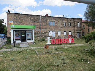
Amasia, previously known as Hamasia, is a village in the Amasia Municipality of the Shirak Province of Armenia. It is located on the right bank of the Akhuryan River.

The Elizavetpol uezd, also known as the Ganja uezd after 1918, was a county (uezd) of the Elizavetpol Governorate of the Russian Empire, and later of the Azerbaijan Democratic Republic and Azerbaijan SSR until its formal abolition in 1929. The area of the Elizavetpol uezd corresponds to the modern-day Gadabay, Shamkir, Dashkasan, Goygol, and Samukh districts of Azerbaijan.
Moscow is the most populous city in Europe and Russia, population of which is mostly made up of ethnic Russians, but it also hosts a significant population of ethnic minorities. The last census of 2021 reported 69.7% of the population was Russian.

The Kutaisi or Kutais Governorate was a province (guberniya) of the Caucasus Viceroyalty of the Russian Empire. It roughly corresponded to most of western Georgia throughout most of its existence, and most of the Artvin Province of Turkey between 1878 and 1903. Created out of part of the former Georgia-Imeretia Governorate in 1846, the governorate also included Akhaltsikhe uezd before its cession to the Tiflis Governorate in 1867. The Kutaisi Governorate bordered the Sukhumi Okrug to the northwest, the Kuban Oblast to the north, the Terek Oblast to the northeast, the Tiflis Governorate to the southeast, the Batum Oblast to the southwest, and the Black Sea to the west. The governorate was eponymously named for its administrative center, Kutais.

The Alexandropol uezd, known after 1924 as the Leninakan uezd, was a county (uezd) of the Erivan Governorate of the Caucasus Viceroyalty of the Russian Empire. The uezd bordered the governorate's Etchmiadzin and Nor Bayazet uezds to the south, the Borchaly and Akhalkalaki uezds of the Tiflis Governorate to the north, the Kazakh uezd of the Elizavetpol Governorate to the east, and the Kars Oblast to the west. The area of the uezd included most of the contemporary Shirak Province, and southern parts of the Lori Province of Armenia. The district was eponymously named for its administrative center, Aleksandropol, which at the time was a major railway hub of the Russian South Caucasus.
The census in Azerbaijan is a process of collecting, summarizing, analyzing and publishing the demographic, economic and social data of the population living in the territory of Azerbaijan. The next census in the Republic is expected to be held in 2029.
Soroksky County was an uezd, one of the subdivisions of the Bessarabia Governorate of the Russian Empire. It was situated in the northern part of the governorate. Its administrative centre was Soroca.
Accurate or reliable data for historical populations of Armenians is scarce, but various scholars and institutions have proposed estimates for different periods.

The Geokchay uezd was a county (uezd) of the Baku Governorate of the Russian Empire and then of the Azerbaijan Democratic Republic and Azerbaijan SSR until its formal abolishment in 1929. The uezd was located in the central part of the governorate, bordering the Kuba uezd to the north, the Shemakha uezd to the east, the Javad uezd to the south and the Elizavetpol Governorate to the west. The administrative center of the uezd was the city of Geokchay.

The Noyemberyan District was a raion (district) of the Armenian Soviet Socialist Republic from 1937 to 1991 and of the Republic of Armenia from 1991 to 1995. It now constitutes the northeastern part of the Tavush Province (marz) of Armenia. Its administrative center was the town of the same name.


