The Arthur Highway (A9) is a Tasmanian highway which runs from Sorell in the near south to Port Arthur in the far south-east.

Camdale is a locality and small rural community in the local government area of Burnie, in the North West region of Tasmania. It is located about 7.5 kilometres (4.7 mi) west of the town of Burnie. The Cam River forms its western boundary, Bass Strait the northern boundary, and the Bass Highway follows the northern boundary. The 2016 census determined a population of 72 for the state suburb of Camdale.
Rocky Cape is a locality and small rural community in the local government area of Circular Head, in the North West region of Tasmania. It is located about 30 kilometres (19 mi) north-west of the town of Wynyard. The Bass Highway passes through from south-east to north-west. The Rocky Cape National Park is in the north-east of the locality. The 2016 census determined a population of 206 for the state suburb of Rocky Cape.
South Burnie is a locality and suburb of Burnie in the local government area of City of Burnie, in the North West region of Tasmania. It is located about 2.5 kilometres (1.6 mi) south-east of the town of Burnie. The Bass Highway passes from south-east to north-west along the shore of Bass Strait, which forms part of the northern boundary. The Emu River forms part of the eastern boundary. The 2016 census determined a population of 331 for the state suburb of South Burnie.
Emu Heights is a locality and suburb of Burnie in the local government area of City of Burnie, in the North West region of Tasmania. It is located about 3.8 kilometres (2.4 mi) south-east of the town of Burnie. The Emu River forms the eastern boundary, and the railway tracks of the Melba line form most of the western. The 2016 census determined a population of 180 for the state suburb of Emu Heights.
Birralee is a locality and small rural settlement in the local government area of Meander Valley, in the Launceston region of Tasmania. It is located about 20 kilometres (12 mi) north of the town of Westbury. Black Sugarloaf Creek, a tributary of the Meander River, forms part of the southern boundary, and part of the eastern boundary runs parallel to Four Springs Creek. The 2016 census determined a population of 182 for the state suburb of Birralee.
Red Hills is a locality and suburb in the local government area of Meander Valley, in the Launceston region of Tasmania. It is located about 7 kilometres (4.3 mi) west of the town of Deloraine. The Meander River forms part of the south-eastern boundary, while its tributary Western Creek forms the remainder. The railway tracks of the Western line pass through the north-eastern corner of the locality, crossing the B12 route at Lemana Junction. The 2016 census determined a population of 120 for the state suburb of Red Hills.
Gawler is a locality and small rural community in the local government area of Central Coast, in the North West region of Tasmania. It is located about 8 kilometres (5.0 mi) south of the town of Ulverstone. The 2016 census determined a population of 622 for the state suburb of Gawler.
Cuprona is a locality and small rural community in the local government area of Central Coast, in the North West region of Tasmania. It is located about 15 kilometres (9.3 mi) south-east of the town of Burnie. The Blythe River forms the western boundary. The 2016 census determined a population of 120 for the state suburb of Cuprona.
Black River is a locality and small rural community in the local government area of Circular Head, in the North West region of Tasmania. It is located about 46 kilometres (29 mi) north-west of the town of Wynyard. Bass Strait forms most of the northern boundary, while the stream named “Black River” forms the western boundary. The 2016 census determined a population of 35 for the state suburb of Black River.
Mengha is a locality and small rural community in the local government area of Circular Head, in the North West region of Tasmania. It is located about 14 kilometres (8.7 mi) south-east of the town of Smithton. The Black River forms part of the eastern boundary. The 2016 census determined a population of 144 for the state suburb of Mengha.
Irishtown is a locality and small rural community in the local government area of Circular Head, in the North West region of Tasmania. It is located about 8 kilometres (5.0 mi) south-east of the town of Smithton. The 2016 census determined a population of 301 for the state suburb of Irishtown.

The River Leven is a perennial river for most of its length, located in the north-western region of Tasmania, Australia. It was named by the Van Diemen's Land Company after the River Leven in Scotland.
The Emu River is a perennial river for most of its length, located in the north-western region of Tasmania, Australia. It was named by Henry Hellyer, an early explorer who saw emu tracks in the vicinity.

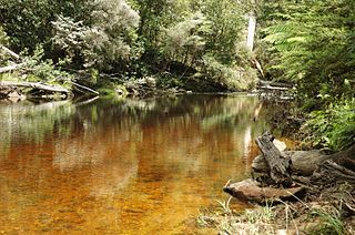
The Black River is a perennial river for most of its length, located in the north-western region of Tasmania, Australia.
Falmouth is a locality and small rural community in the local government area of Break O'Day, in the North-east region of Tasmania. It is located about 14 kilometres (8.7 mi) north-east of the town of St Marys. The Tasman Sea forms most of its eastern boundary, with the remainder being the centre line of Henderson Lagoon. The 2016 census determined a population of 102 for the state suburb of Falmouth.
Lanena is a locality and small rural community in the local government area of West Tamar, in the Western Tamar Valley region of Tasmania. It is located about 24 kilometres (15 mi) north-west of the town of Launceston. The Tamar River forms the north-eastern and eastern boundaries. The 2016 census determined a population of 320 for the state suburb of Lanena.
Loira is a locality and small rural community in the local government area of West Tamar, in the Western Tamar Valley region of Tasmania. It is located about 31 kilometres (19 mi) north-west of the town of Launceston. The Supply River forms the southern and part of the eastern boundaries. The 2016 census determined a population of 160 for the state suburb of Loira.
Gravelly Beach is a locality and small rural community in the local government area of West Tamar, in the Western Tamar Valley region of Tasmania. It is located about 28 kilometres (17 mi) north-west of the town of Launceston. The Tamar River forms the eastern boundary. The 2016 census determined a population of 567 for the state suburb of Gravelly Beach.
Deviot is a locality and small rural community in the local government area of West Tamar, in the Western Tamar Valley region of Tasmania. It is located about 35 kilometres (22 mi) north-west of the town of Launceston. The Tamar River forms the eastern and north-eastern boundaries. The 2016 census determined a population of 337 for the state suburb of Deviot.


