Dooley, Montana

Last updated

Dooley
USA Montana location map.svg
Red pog.svg
Dooley
Location of Dooley in Montana
Usa edcp location map.svg
Red pog.svg
Dooley
Dooley (the United States)
Coordinates: 48°52′52″N104°23′22″W / 48.88111°N 104.38944°W / 48.88111; -104.38944 [1]
Country United States
State Montana
County Sheridan
Established1913
Abandoned1957
Elevation
2,461 ft (750 m)

Dooley is a ghost town in northeastern Sheridan County, Montana, United States. The town was established as a station stop and one of the first four depots along the Soo Line Railroad branch line to Whitehall. [2]

Contents

History

The town began in 1912 or earlier, when the railroad was coming through and landed on the corner of W.D Dooley's property. Around 40 buildings went up at once, to become the business area. [3] It was one of the only towns not to move since the beginning of the railroad. [4] George Epler was the town cashier and the organizer of the Citizen State Bank. Guy Clerke and the Epler Brothers had two general stores in town. George Wright owned the hardware store, where they would hold different gatherings upstairs, until the theater was built. The Confectionery and the post office was owned by Peter Hegseth. The post office at Dooley operated from at least 1912 to 1957. [5] He had to rebuild them after they caught in a fire. There were two saloons in town; one was owned by Hans Nelson and the other by Jim Kings. [3]

Although the land around Dooley attracted numerous homesteaders during the first years following the railroad's completion, the region proved to be unsuited for intensive agricultural use, and by the 1920s the town was in decline. Though the railroad remains in operation, Dooley is now a ghost town. The only building that was still standing is the long-abandoned Rocky Valley Lutheran Church, which was listed on the National Register of Historic Places in 1993. [6] The church collapsed on the morning of July 8, 2019. [7]

Ted Nelson was a popular man in town and owned many of the businesses. He bought the Herman Bretzke building and started the first restaurant in Dooley. Mrs. Nelson managed the restaurant. The Racket (Variety) Store was owned by Ted. Ted also then bought and started a meat market, and had Christ Grythnes as the meat cutter. His meat market was one of the two in town. The other was caught in all three of Dooley’s fires. [3]

The first edition of the newspaper, The Dooley Sun was dated November 7, 1913. The paper was owned and edited by W.R. Vezina. The electric plant was run by Loyal Goss. He had also bought the Feed Mill from M.E. Lerbeck and Iver Johnson. The power was turned on every evening till midnight, also on Tuesdays during the day for a few hours for the women to do the washing and ironing. [3] The power would blink ten minutes before midnight to let everyone know that it would be turned off shortly. [8] The blacksmith shop was owned by Ed Campell and Newt Shaw. They did very well in their business, sharpening plowshares and keeping machinery in shape. The blacksmith shop had a few owners after the original ones moved away. There were other business around the town, some of them were short lived, while others were sold to new owners. There were two doctors in town, Dr. Sells and Dr. Cooper. There were a lot of different business in the early days of Dooley. As time went on they slowly died out. [3] [4] The town had a Commercial Club, Fire Department, a band and a baseball team. There were two barbers in town. At one time there were four different lumber yards. [4]

There were three elevators built, because of the large amount of grain that crossed the Canada–US border. Nels Markuson managed the elevators. Otto and Arthur Stadig built a big barn to board horses. They were able to care for over 100 horses. The mail was delivered from Plentywood in 1913–1914. The first postmaster of Dooley was Peter Hegseth, who ran the office out of his house. There were two other postmasters, Willard Markuson and Ambrose Schumacher. The post office was closed in June 1957, and a route was established out of Westby. Church was held in George Wrights Hall, and led by Rev. F.E. Henry. Then it was held by Fr. Hennssey. The Rocky Valley Lutheran Church was built in 1915. The Ladies Aid furnished it. The first minister was Rev. S.J. Fretheim, and his first serviced was held in P.T. Hegseth farm house. After 1945 the church had closed due to so many people leaving the area, and was sold to a local farmer.

In the fall of 1913, the school district was formed along with the school board that consisted of, Jim King, George Epler, and W.D. Dooley. For three years an old homestead shack was used as their classroom, where Miss Alice Murphy taught. In 1915 a school was built and the classes become more regular. Until 1931 the grade school children were taught in the large room, and then it was decided that a high school should be built. The new high school had its first graduating class in 1932, with six students. The high school also had their own newspaper, "The Dooley Dew," then later changed to fit the mascot to "The Eagle Eye." The high school tried to create a radio station, but due to the lack of power they never bought a license for it. Over time the families around moved away and the local children were bused to Plentywood for school. [2] [4]

Dooley suffered many different kinds of disasters. In May 1916, the west side of Main Street caught on fire, wrecking many of the businesses. Four years later the east side suffered a fire destroying many of the local businesses. Also a year before, in 1919 a smaller fire took place and wrecked a garage and two smaller businesses. In 1934 a tornado came through town, wiping out the Stadig Livery Barn. [2] The town also suffered infestations of armyworms, grasshoppers and Mormon crickets, which harmed local agriculture. [8] Some of the winters that the town faced were very severe and kept the train from passing through. The trains feared that they would freeze up or run out of fuel. [9]

Over the years people moved to the surrounding areas due to the fires and infestations. The town's population slowly dwindled and the buildings were sold or torn down. The elevators were sold to Jim Syme. [9]

See also

Notes

  1. "Dooley". Geographic Names Information System . United States Geological Survey, United States Department of the Interior.
  2. 1 2 3 Budke et al 3
  3. 1 2 3 4 5 Budke et al 1
  4. 1 2 3 4 Budke et al 2
  5. "Sheriden [sic] County Post Offices". Postalhistory.com. Retrieved March 28, 2008.
  6. "MONTANA – Sheridan County". National Register of Historic Places. Retrieved January 30, 2008.
  7. Instagram, personal correspondence 2021-08-19
  8. 1 2 Aarstad et al 69
  9. 1 2 Budke et al 4

Related Research Articles

<span class="mw-page-title-main">Sheridan County, Montana</span> County in Montana, United States

Sheridan County is a county in the U.S. state of Montana. As of the 2020 census, the population was 3,539. Its county seat is Plentywood. Its northern boundary is the Canada–United States border south of Saskatchewan.

<span class="mw-page-title-main">Calamus, Iowa</span> City in Iowa, United States

Calamus is a small town in Clinton County, Iowa, United States, located on the historical Lincoln Highway, which was the first transcontinental highway for automobiles across the U.S.. Calamus is the only town in Olive Township and had a population of 356 at the 2020 census, which was a 9.6% decrease from 2000. Calamus was named after Calamus Creek, which received its name from the great quantities of sweet flag growing in it, derived from the botanical name Acorus calamus, commonly called Sweet Flag or Calamus.

<span class="mw-page-title-main">Lake Crystal, Minnesota</span> City in Minnesota, United States

Lake Crystal is a city in Blue Earth County, Minnesota, United States, established in 1869. The population was 2,539 at the 2020 census. It is part of the Mankato-North Mankato Metropolitan Statistical Area.

<span class="mw-page-title-main">Bearcreek, Montana</span> Incorporated town in Montana, United States

Bearcreek is an incorporated town in Carbon County, Montana, United States. It is part of the Billings, Montana Metropolitan Statistical Area. The population was 91 at the 2020 census. Bearcreek uses the Mayor/Council form of government.

<span class="mw-page-title-main">Livingston, Montana</span> City in Park County, Montana, United States

Livingston is a city and county seat of Park County, Montana, United States. It is in southwestern Montana, on the Yellowstone River, north of Yellowstone National Park. As of the 2020 census, the population of the city was 8,040.

<span class="mw-page-title-main">Antelope, Montana</span> CDP in Montana, United States

Antelope is a census-designated place (CDP) in Sheridan County, Montana, United States. The population was 51 at the 2010 census.

<span class="mw-page-title-main">Plentywood, Montana</span> City in Montana, United States

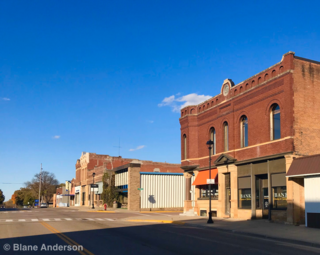
Plentywood is a city in and the county seat of Sheridan County, Montana, United States. The population was 1,669 at the 2020 census.

<span class="mw-page-title-main">Hysham, Montana</span> Town in Montana, United States

Hysham is a town in and the county seat of Treasure County, Montana, United States. The population was 276 at the 2020 census.

<span class="mw-page-title-main">Chapin, South Carolina</span> Town in South Carolina, United States

Chapin, popularly known as the "Capital of Lake Murray", is a small lake town located at the northern tip of Lexington County, South Carolina, United States. Lake Murray separates Chapin from the rest of Lexington County. The population of Chapin was 1,445 according to the 2010 census, and an estimated 1,633 in 2019.

<span class="mw-page-title-main">Elkhorn, Montana</span> Census-designated place in Montana, United States

Elkhorn is a census-designated place (CDP) in Jefferson County, Montana, United States, in the Elkhorn Mountains of the southwestern part of the state. As of the 2010 census it had a population of 10. The community is considered a ghost town, and two of its buildings are preserved as Elkhorn State Park.

<span class="mw-page-title-main">Lafleche, Saskatchewan</span> Town in Saskatchewan, Canada

Lafleche is a small town in southwest Saskatchewan, Canada in the Rural Municipality of Wood River No. 74. The community is located at the intersection of Highway 13 and Highway 58. It is 20 km south of Gravelbourg and 45 km west of Assiniboia. It is situated on the south bank of Lafleche Creek, which is a tributary of Wood River. Thomson Lake Regional Park is located 10 minutes north of town.

<span class="mw-page-title-main">Rapelje, Montana</span> Census-Designated Place in Montana, United States

Rapelje is an unincorporated community and census-Designated Place in northern Stillwater County, Montana, United States. Rapelje was named for J. M. Rapelje, general manager and vice president of the Northern Pacific Railway. Rapelje had a population of approximately 110 people as of the 2000 census. Rapelje is located 24 miles north of Columbus on Montana Secondary Highway 306.

Rockglen is a town in the Burning Hills of the Wood Mountain Uplands, in Saskatchewan, Canada. It offers various amenities including a school, community hall, public library and five parks, as well a local service industry. The municipal office of the Rural Municipality of Poplar Valley No. 12 lies within the boundaries of Rockglen, and Rockglen businesses are supported primarily by agriculture. In the Burning Hills agriculture consists of dry land farming and cattle. Rockglen is located along Highway 2 south of Assiniboia, Highway 18 west of Coronach, and Highways 2 and 18 north of Port Poplar River. Fife Lake is 9.3 kilometres (5.8 mi) to the east.

Glasston is a farming town located in Saint Thomas Township in North Dakota's Pembina County, United States. It consists of a post office, a general store, and a handful of houses. It was established in 1886 as a station along the Great Northern Railroad. Originally called Baltimore, the site was later renamed for Archibald Glass, its first postmaster. The population of the village has rarely exceeded 100 since it was established.

<span class="mw-page-title-main">Baden, St. Louis</span> Neighborhood of St. Louis in Missouri, United States

Baden is a neighborhood of St. Louis, Missouri.

<span class="mw-page-title-main">Maybutt, Alberta</span> Settlement in Alberta, Canada (est. 1890)

Maybutt, also known as "New Stirling" or "New Town", is a former locality in the County of Warner No. 5, Alberta, Canada. The community is situated 1 km north of the Village of Stirling just off the CANAMEX Corridor between Lethbridge and the Canada–US border. The community has become a bedroom community to Lethbridge, with many newer acreages being developed in the area. The footprint of Maybutt is defined by its historic boundary roads, Young St., Sunnyside Ave., Front St. & Lorne Ave, and Etzikom Ave. York St., First Ave. and Second Ave. are the only interior streets left of the original street grid of Maybutt.

Radium is an unincorporated community in section 19 of Comstock Township, Marshall County, Minnesota, United States. It was built alongside the Minneapolis, St. Paul and Sault Ste. Marie Railroad branch line built in 1905 from Thief River Falls, Minnesota, to Kenmare, North Dakota. The place was named for the element radium. Radium had its own post office from 1905 to 1984. Since 1984, Radium has been served by the post office in Warren. It is also on the Warren telephone exchange and part of the Warren-Alvarado-Oslo school district. The townsite is being slowly reclaimed for use as farmland. There is still a large grain elevator on the railroad line south of the townsite. A small Lutheran church 1+12 miles (2.4 km) south of the town antedates the coming of the railroad; Immanuel Lutheran Church (LCMS) was organized in 1897.

<span class="mw-page-title-main">Mondak, Montana</span> Ghost town in Montana, United States

Mondak is a ghost town in Roosevelt County, Montana, United States, which flourished c. 1903–1919, in large measure by selling alcohol to residents of North Dakota, then a dry state.

<span class="mw-page-title-main">Miles City, Montana</span> City in Montana, United States

Miles City is a city in and the county seat of Custer County, Montana, United States. The population was 8,354 at the 2020 census.

<span class="mw-page-title-main">Horizon, Saskatchewan</span> Unincorporated Community in Saskatchewan, Canada

Horizon, located on the south side of Channel Lake, is a hamlet in Bengough Rural Municipality No. 40, Saskatchewan, Canada. It previously held the status of village until December 31, 1973. The hamlet is located 60 km (37 mi) east of the Town of Assiniboia on highway 13.

References