
Deale is a census-designated place (CDP) in Anne Arundel County, Maryland, United States. The population was 4,945 at the 2010 census. It has a scenic view of Chesapeake Bay and is popular with boaters. Sudley was listed on the National Register of Historic Places in 1973.

Lake Shore is a census-designated place and unincorporated community in Anne Arundel County, Maryland, United States, located east of Pasadena. The population of Lake Shore was 19,477 at the 2010 census.

Mayo is a census-designated place (CDP) in Anne Arundel County, Maryland, United States. The population was 8,298 at the 2010 census. The Mayo CDP of 2010 includes all of the area that used to be counted as the Selby-on-the-Bay CDP. The beach in Mayo used to be a popular weekend resort.

Pasadena is a census-designated place (CDP) in Anne Arundel County, Maryland, United States. The population was 24,287 at the 2010 census.
Essex is an unincorporated community and census-designated place in Baltimore County, Maryland, United States. Essex has a long history dating back to 1909. The population was 39,262 at the 2010 census and is growing in population each year. The town hosts beaches, parks, wetlands, a courthouse, and a museum which was once a school, courthouse, jail, and firehouse. The town has a strip of shops known as the business district on Eastern boulevard starting from Virginia avenue to Marlyn avenue. The business district originally started from Mace avenue to Marlyn Avenue. Its largest shopping center, Middlesex, was built in 1955 which once had a department store Montgomery Ward and food fair as the anchors of the shopping center.

Lusby is an unincorporated community and census-designated place (CDP) in Calvert County, Maryland, United States. The population of the CDP was 1,835 at the 2010 census. Residents of the Chesapeake Ranch Estates and Drum Point communities also use the Lusby ZIP code designation.

Owings is a town center and census-designated place (CDP) in northern Calvert County, Maryland, United States. The population was 2,149 at the 2010 census, up from 1,325 in 2000.

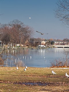
Solomons, also known as Solomons Island, is an unincorporated community and census-designated place (CDP) in Calvert County, Maryland, United States. The population was 2,368 at the 2010 census, up from 1,536 in 2000. Solomons is a popular weekend destination spot in the Baltimore–Washington metropolitan area.

Edgewood is an unincorporated community and census-designated place (CDP) in Harford County, Maryland, United States. The population was 25,562 at the 2010 census, up from 23,378 in 2000.
Choptank is an unincorporated town and census-designated place on the Eastern Shore of Maryland, in Caroline County, Maryland, United States. As of the 2010 census it had a population of 129.
The Chesapeake Ranch Estates (CRE), also known locally as the Ranch Club, is located in Lusby, Maryland, United States, in southern Calvert County. CRE was founded in 1958 and is governed by a homeowners' association, which is officially called the "Property Owner's Association of the Chesapeake Ranch Estates" (POACRE). Today, CRE is composed of over 4,000 homes. The community is counted as a census-designated place for population statistics, with a residential population of 10,519 as of the 2010 census. At the 2000 census, the area was part of the Chesapeake Ranch Estates-Drum Point CDP.
Romancoke is a census-designated place on Queen Anne's in Maryland, United States, located at the southern terminus of Maryland Route 8. Romancoke was changed from an unincorporated community to a census-designated place for the 2020 Census listing a population of 1,855. The name "Romancoke" comes from the Algonquian word for "circling of the water." William Claiborne, who founded Kent Island, also had a plantation in Virginia named Romancoke.
Little Orleans is an unincorporated community and census-designated place (CDP) in Allegany County, Maryland, United States. As of the 2010 census it had a population of 42.

Spring Gap is an unincorporated community and census-designated place (CDP) in Allegany County, Maryland, United States. As of the 2010 census it had a population of 55.

Galesville is an unincorporated town and census-designated place (CDP) in Anne Arundel County, Maryland, United States. As of the 2010 census, it had a population of 685.
Queen Anne in Prince George's County, Maryland, United States, is a former seaport on the Patuxent River. It was delineated as a CDP for the 2010 census, at which time it had a population of 1,280. Per the 2020 census, the population was 1,405.

Taylors Island is an unincorporated community and census-designated place in Dorchester County, Maryland, United States, in the state's Eastern Shore region. The population was 173 at the 2010 census. It is known for hunting, crabbing and fishing. Ridgeton Farm was listed on the National Register of Historic Places in 1977. Bethlehem Methodist Episcopal Church and Grace Episcopal Church Complex were listed in 1979.

Madison is an unincorporated community and census-designated place (CDP) in Dorchester County, Maryland, United States. The population was 204 at the 2010 census.
Georgetown is an unincorporated community and census-designated place in western Kent County, Maryland, United States.Per the 2020 census, the population was 117. It should not be confused with the community of the same name 22 miles (35 km) to the northeast on the Kent/Cecil County border.
Chesapeake Landing is a census designated place in Kent County, Maryland, United States. Per the 2020 Census, the population was 472.

