
The Lewis and Clark Expedition, also known as the Corps of Discovery Expedition, was the United States expedition to cross the newly acquired western portion of the country after the Louisiana Purchase. The Corps of Discovery was a select group of U.S. Army and civilian volunteers under the command of Captain Meriwether Lewis and his close friend Second Lieutenant William Clark. Clark, along with 30 others, set out from Camp Dubois, Illinois, on May 14, 1804, met Lewis and ten other members of the group in St. Charles, Missouri, then went up the Missouri River. The expedition crossed the Continental Divide of the Americas near the Lemhi Pass, eventually coming to the Columbia River, and the Pacific Ocean in 1805. The return voyage began on March 23, 1806, at Fort Clatsop, Oregon, ending six months later on September 23 of that year.

The Louisiana Purchase was the acquisition of the territory of Louisiana by the United States from the French First Republic in 1803. This consisted of most of the land in the Mississippi River's drainage basin west of the river. In return for fifteen million dollars, or approximately eighteen dollars per square mile, the United States nominally acquired a total of 828,000 sq mi in Middle America. However, France only controlled a small fraction of this area, most of which was inhabited by Native Americans; effectively, for the majority of the area, the United States bought the preemptive right to obtain Indian lands by treaty or by conquest, to the exclusion of other colonial powers.
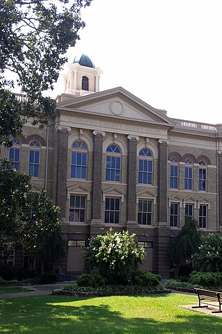
Garland County is located in the U.S. state of Arkansas. As of the 2020 census, the population was 100,180. The county seat is Hot Springs.

Bradley County is a county located in the U.S. state of Arkansas. As of the 2020 census, the population was 10,545. The county seat is Warren. It is Arkansas's 43rd county, formed on December 18, 1840, and named for Captain Hugh Bradley, who fought in the War of 1812.

Rockport is a city in Hot Spring County in the U.S. state of Arkansas. As of the 2010 census, the population of Rockport was 755, down from 792 in 2000.

Camden is a city in and the county seat of Ouachita County in the south-central part of the U.S. state of Arkansas. The city is located about 100 miles south of Little Rock. Situated on bluffs overlooking the Ouachita River, the city developed because of the river.

The Territory of Louisiana or Louisiana Territory was an organized incorporated territory of the United States that existed from July 4, 1805, until June 4, 1812, when it was renamed the Missouri Territory. The territory was formed out of the District of Louisiana, which consisted of the portion of the Louisiana Purchase north of the 33rd parallel.

The Red River, or sometimes the Red River of the South to differentiate it from the Red River in the north of the continent, is a major river in the Southern United States. It was named for its reddish water color from passing through red-bed country in its watershed. It is known as the Red River of the South to distinguish it from the Red River of the North, which flows between Minnesota and North Dakota into the Canadian province of Manitoba. Although once a tributary of the Mississippi River, the Red River is now a tributary of the Atchafalaya River, a distributary of the Mississippi that flows separately into the Gulf of Mexico. This confluence is connected to the Mississippi River by the Old River Control Structure.
Zebulon Montgomery Pike was an American brigadier general and explorer for whom Pikes Peak in Colorado is named. As a U.S. Army officer he led two expeditions through the Louisiana Purchase territory, first in 1805–1806 to reconnoiter the upper northern reaches of the Mississippi River, and then in 1806–1807 to explore the southwest to the fringes of the northern Spanish-colonial settlements of New Mexico and Texas. Pike's expeditions coincided with other Jeffersonian expeditions, including the Lewis and Clark Expedition and the Red River Expedition in 1806.
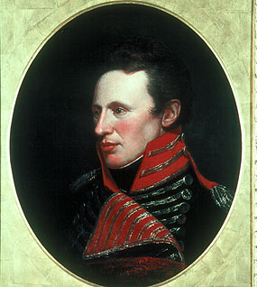
The Pike Expedition was a military party sent out by President Thomas Jefferson and authorized by the United States government to explore the south and west of the recent Louisiana Purchase. Roughly contemporaneous with the Lewis and Clark Expedition, it was led by United States Army Lieutenant Zebulon Pike, Jr. who was promoted to captain during the trip. It was the first official American effort to explore the western Great Plains and the Rocky Mountains in present-day Colorado. Pike contacted several Native American tribes during his travels and informed them that the U.S. now claimed their territory. The expedition documented the United States' discovery of Tava which was later renamed Pikes Peak in honor of Pike. After splitting up his men, Pike led the larger contingent to find the headwaters of the Red River. A smaller group returned safely to the U.S. Army fort in St. Louis, Missouri before winter set in.

The Ouachita Mountains, simply referred to as the Ouachitas, are a mountain range in western Arkansas and southeastern Oklahoma. They are formed by a thick succession of highly deformed Paleozoic strata constituting the Ouachita Fold and Thrust Belt, one of the important orogenic belts of North America. The Ouachitas continue in the subsurface to the northeast, where they make a poorly understood connection with the Appalachians and to the southwest, where they join with the Marathon uplift area of West Texas. Together with the Ozark Plateaus, the Ouachitas form the U.S. Interior Highlands. The highest natural point is Mount Magazine at 2,753 feet (839 m).

The Ouachita River is a 605-mile-long (974 km) river that runs south and east through the U.S. states of Arkansas and Louisiana, joining the Tensas River to form the Black River near Jonesville, Louisiana. It is the 25th-longest river in the United States.

The Corps of Discovery was a specially established unit of the United States Army which formed the nucleus of the Lewis and Clark Expedition that took place between May 1804 and September 1806. The Corps was led jointly by Captain Meriwether Lewis and Second Lieutenant William Clark. Commissioned by President Thomas Jefferson, the Corps' objectives were scientific and commercial – to study the area's plants, animal life, and geography, and to learn how the Louisiana Purchase could be exploited economically. Aside from its military composition, the Corps' additional personnel included scouts, boatmen, and civilians.

The Territory of Orleans or Orleans Territory was an organized incorporated territory of the United States that existed from October 1, 1804, until April 30, 1812, when it was admitted to the Union as the State of Louisiana.
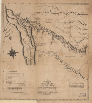
The Red River Expedition, also known as the Freeman–Custis Expedition, Freeman Red River Expedition, Sparks Expedition, and officially Exploring Expedition of Red River, was one of the first civilian scientific expeditions to explore the Southwestern United States. The 1806 expedition was ordered to find the headwaters of the Red River from the Mississippi River as a possible trading route to Santa Fe, which was then under Spanish colonial control in New Mexico; to contact Native American peoples for trading purposes; to collect data on flora, fauna, and topography, and map the country and river; and to assess the land for settlement. The Spanish officials intercepted the expedition 615 miles upriver, in what is now northeastern Texas, and turned it back before the party had achieved all of its goals.

William Dunbar (1749–1810) was a Scottish-American merchant, plantation owner, naturalist, astronomer and explorer.

The geography of Arkansas varies widely. The state is covered by mountains, river valleys, forests, lakes, and bayous in addition to the cities of Arkansas. Hot Springs National Park features bubbling springs of hot water, formerly sought across the country for their healing properties. Crowley's Ridge is a geological anomaly rising above the surrounding lowlands of the Mississippi embayment.
Events from the year 1805 in the United States.

José Joaquín de Ferrer y Cafranga was a Spanish Basque astronomer.

The early history of the Arkansas Valley in Colorado began in the 1600s and to the early 1800s when explorers, hunters, trappers, and traders of European descent came to the region. Prior to that, Colorado was home to prehistoric people, including Paleo-Indians, Ancestral Puebloans, and Late prehistoric Native Americans.
